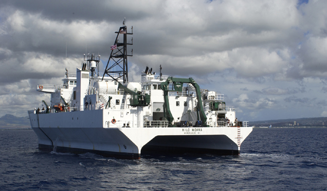
While in transit from Hawaii to Guam, the research vessel Kilo Moana detected the February 2012 Chilean tsunami. (Photo courtesy of University of Hawaii, School of Ocean and Earth Science and Technology)
From SOEST
Commercial ships travel across most of the globe and could provide better warnings for potentially deadly tsunamis, according to a study published May 5 by scientists at the University of Hawaii – Manoa (UHM) and the National Oceanic and Atmospheric Administration's Pacific Tsunami Warning Center. (see AGU)
James Foster, lead author and Assistant Researcher at the UH School of Ocean and Earth Science and Technology (SOEST), and colleagues were able to detect and measure the properties of the tsunami generated by the magnitude 8.8 earthquake in Maule, Chile (February 2010), even though, out in the open ocean, the wave was only about 4 inches (9.4 cm) high.
The UH research vessel Kilo Moana was on its way from Hawaii to Guam at the time of the tsunami, and was equipped with geodetic GPS system recording data as the tsunami passed by.

Position of R/V Kilo Moana during 2010 Chile tsunami
Careful analysis of this data showed that the researchers were able to detect changes in the sea-surface height very similar to the Pacific Tsunami Warning Center predictions.
This finding came as a surprise because tsunamis have such small amplitudes in the deep water, in contrast to their size when they reach the coastline, that it seemed unlikely that the tsunami would be detected using GPS unless the ship was very close to the source and the tsunami was very big.
"Our discovery indicates that the vast fleet of commercial ships traveling the ocean each day could become a network of accurate tsunami sensors," Foster said.
Although the initial warning for a tsunami is based on seismic data from the earthquake, the details about whether a tsunami was actually generated, how big it is, and where the energy is directed are currently provided by tide gauges and deep ocean pressure sensors (DART system).
This is the information that is needed to accurately predict how big the tsunami will be for specific locations, and whether or not an evacuation, and the associated cost, is necessary.
Tide gauges are restricted to land and therefore are sparsely distributed, while the DART systems are very expensive and hard to maintain.
Consequently, during the 2010 Chilean earthquake, the DART sensor closest to Hawaii was out of order. In fact, nearly 30% of that network was down at the time.
Commercial shipping lines, however, run all around the Pacific basin and provide great coverage globally around tsunamigenic regions (areas of the Earth that produced tsunamis).
"If we could equip some fraction of the shipping fleet with high-accuracy GPS and satellite communications, we could construct a dense, low-cost tsunami sensing network that would improve our detection and predictions of tsunamis -- saving lives and money," Foster commented.
Foster and co-authors estimate that this sort of ship-based system would have been able to detect the 2004 Indian Ocean tsunami within an hour, potentially save thousands of lives.
"There are so many ships out there that if you've got enough of them instrumented with the GPS systems there is always going to be some ships in the neighborhood of the region that produces the tsunami," said Foster.
Much more advanced than a handheld GPS, the unit on a ship would include a round antenna to help measure and transmit even the slightest wave height changes from a tsunami that would likely go unnoticed in the open ocean.
The difference being measured in length of time.
"An open ocean swell has a period of maybe 15 seconds, 20 seconds. A tsunami takes maybe 20 minutes, half an hour to pass," said Foster.
At $15,000 to $20,000 per unit, the GPS is cheaper than the current deep ocean buoys that provide tsunami data.

GPS
Tsunami Meter utilizes floating buoy as observation instrument, in
which Real-Time Kinematic GPS antenna is attached on the top of the buoy
body
The challenge will be getting the commercial shipping lines to jump on board to create a mobile tsunami detection system.
Foster and fellow SOEST researchers plan to deploy a demonstration system which will stream GPS data from one or two ships, thus generating accurate real-time heights and confirming that this approach can achieve the accuracy needed for tsunami detection.
As a bonus, the same processing system will generate data that meteorologists can use to improve weather forecasts.
Links :
- CBC : Researchers use GPS data to speed up tsunami warnings
- Natural Hazards & Earth System Sciences : GPS water level measurements for Indonesia’s Tsunami Early Warning System / Near real-time GPS applications for tsunami early warning systems
- BBC : GPS network is quick quake sensor
No comments:
Post a Comment