
Situation 24/01/2012 08:00 UTC

>>> geolocalization with the Marine GeoGarage <<<

The Archipelago of the Azores is
composed of nine volcanic islands situated in the North Atlantic Ocean,
and is located about 1,500 km (930 mi) west of Lisbon.
The
islands, and their Exclusive Economic Zone, form the Autonomous Region
of the Azores, one of the two autonomous regions of Portugal.

"Açores Insulae" ("Ilhas dos Açores"), Luís Teixeira, c. 1584.
The discovery and settlement of the Azores archipelago, much like the islands of Madeira, is one of the more controversial aspects of the Portuguese Age of Discovery.
In addition to many theories, myths and stories written about the Azores
there have been various Genovese and Catalan maps produced since 1351
that identified islands in the Atlantic.
Some chroniclers note that sailors knew of the islands, and visited them during return voyages from the Canary Islands (about 1340–1345), during the reign of King Afonso IV.
In "A History of the Azores" by Thomas Ashe written in 1813 the author identified a Fleming, Joshua Vander Berg of Bruges, who made land in the archipelago during a storm on his way to Lisbon.
Ashe then claimed that the Portuguese explored the area and claimed it for Portugal shortly after.
Other stories note the discovery of the first islands (São Miguel Island, Santa Maria Island and Terceira Island) were made by sailors in the service of Henry the Navigator, although there are few written documents to support the claims.
Supporting
the official history of the islands are latter day writings, based on
oral tradition, that appeared in the first half of the 15th century.
Legends and myths also developed during pre-official history to include myths about Prester John, the "Ilhas Afortunadas" (the Fortunate Isles), the "Ilhas Azuis" (the Blue Islands), the "Ilhas Cassiterides"
(the islands of Tin and Silver) or "Ilhas de Sete Cidades" (the islands
of the Seven Cities), all noting the knowledge of undiscovered lands in
the middle of the Atlantic.
Officially, the first islands were "discovered" in the 15th century (in 1431) by Gonçalo Velho Cabral a Captain in the service of Infante D. Henrique, though credit is also given to the explorer Diogo de Silves (in 1427).
Although it is commonly said that the archipelago received its name for the goshawk (Açor
in Portuguese) due to its being a common bird at the time of discovery,
it is unlikely that the bird nested or hunted in the islands.
Some people, however, insist that the name is derived from birds, pointing to a local subspecies of the buzzard (Buteo buteo) as the animal the first explorers erroneously identified as goshawks.
These islands have naturally evolved into three recognizable groups located within the Azores Platform and they are:
- The Eastern Group (Grupo Oriental) of São Miguel, Santa Maria and Formigas Islets
- The Central Group (Grupo Central) of Terceira, Graciosa, São Jorge, Pico and Faial
- The Western Group (Grupo Ocidental) of Flores and Corvo.
In addition, several sub-surface reefs (particularly the Dollabarat on the fringe of the Formigas), banks (specifically the Princess Alice Bank and D. João de Castro Bank, as well as many hydrothermal vents and sea-mounts
are monitored by the regional authorities, owing to the complex
geotectonic and socioeconomic significance within the economic exclusion
zone of the archipelago.

The Azores has had a long history of water transport to overcome distances and establish inter-community contacts and trade.
Consequently, the shipbuilding industry developed in many islands, from small fishing boats, to whaling sloops to larger passenger services.
Passenger traffic to the main islands (São Miguel, Santa Maria, Terceira and Faial) began in the 17th century.

The Azores High (also known as North Atlantic (Subtropical) High/Anticyclone or for short, NASH, the Bermuda-Azores High, or the Bermuda High/Anticyclone in the United States) is a large subtropical semi-permanent centre of high atmospheric pressure typically found south of the Azores in the Atlantic Ocean, at the Horse latitudes.
It forms one pole of the North Atlantic oscillation, the other being the Icelandic Low.
The system influences the weather and climatic patterns of vast areas of North Africa and Europe, and to a lesser extent, eastern North America.
The aridity of the Sahara Desert and Mediterranean Basin is due to the subsidence of air in the system.
In summer, the central pressure hovers around 1024 mbar (hPa).
When it moves north towards the Iberian Peninsula it causes ridging to develop for short periods across northern France, Benelux, Germany and southeastern United Kingdom.
This brings hot and dry weather to these areas normally affected by prevailing westerlies.
The Azores High is known more commonly as the Bermuda High because of the strong westward ridging that develops near Bermuda, usually after the summer solstice.
This can contribute to intense heat waves in the eastern United States and, spotty drought.
Before the onset of winter, the High moves south of the Azores, allowing low pressure systems to invade the Iberian Peninsula and the Mediterranean.

A long tradition in Horta (Faial island) is to paint a remembrance of your ship.
The Azores has had a long history of water transport to overcome distances and establish inter-community contacts and trade.
Consequently, the shipbuilding industry developed in many islands, from small fishing boats, to whaling sloops to larger passenger services.
Passenger traffic to the main islands (São Miguel, Santa Maria, Terceira and Faial) began in the 17th century.
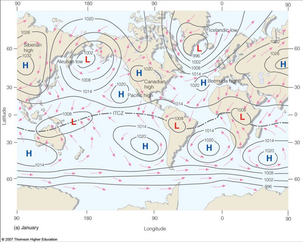
Observed average surface pressure and winds during January
with semi-permanent pressure areas for Bermuda-Azores High
The Azores High (also known as North Atlantic (Subtropical) High/Anticyclone or for short, NASH, the Bermuda-Azores High, or the Bermuda High/Anticyclone in the United States) is a large subtropical semi-permanent centre of high atmospheric pressure typically found south of the Azores in the Atlantic Ocean, at the Horse latitudes.
It forms one pole of the North Atlantic oscillation, the other being the Icelandic Low.
The system influences the weather and climatic patterns of vast areas of North Africa and Europe, and to a lesser extent, eastern North America.
The aridity of the Sahara Desert and Mediterranean Basin is due to the subsidence of air in the system.
In summer, the central pressure hovers around 1024 mbar (hPa).
When it moves north towards the Iberian Peninsula it causes ridging to develop for short periods across northern France, Benelux, Germany and southeastern United Kingdom.
This brings hot and dry weather to these areas normally affected by prevailing westerlies.
The Azores High is known more commonly as the Bermuda High because of the strong westward ridging that develops near Bermuda, usually after the summer solstice.
This can contribute to intense heat waves in the eastern United States and, spotty drought.
Before the onset of winter, the High moves south of the Azores, allowing low pressure systems to invade the Iberian Peninsula and the Mediterranean.
No comments:
Post a Comment