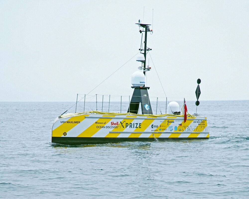
The Maxlimer on its return from the Atlantic.
Photographer: Rich Edwards, Enp Media
Photographer: Rich Edwards, Enp Media
From Bloomberg by Amy Thomson
A comprehensive atlas would help find minerals needed for electric cars and mobile phones.
On July 24 a 40-foot-long boat called Maxlimer set out from the port of Plymouth on the southern coast of England, steering southwest out of the English Channel into the open ocean.
The unmanned vessel, guided by pilots at a computer onshore, carries sonar that sends out an average of 10,000 sound pulses per hour to chart the topography of the ocean floor.
The goal of the boat’s three-week journey was to put together for the first time a detailed map of about 600 square miles of Europe’s continental shelf, the place where the ocean floor plunges from a few hundred feet beneath the surface to several thousand.
As the Maxlimer’s sonar pings bounced off the seabed, scientists around the world took turns listening for alarms indicating gales, approaching ships, or problems with the vessel’s sensors.
The Maxlimer, whose bullet-shaped hull looks like a submarine that’s just surfaced, had never spent this long a time in such a harsh environment, and researchers fretted a storm might hobble it, says Neil Tinmouth, 37, chief operating officer of Sea-Kit International Ltd., the company that builds the £1.3 million ($1.7 million) boats.
“We wanted to push the limits,” he says, “to do operations in open oceans where you don’t know what you’re going to encounter.”
Sea-Kit is at the forefront of accelerating efforts to map the ocean floor, a terrain that’s less understood than the surfaces of the moon or Mars.
Only 20% of the seabed has been mapped, and an atlas would boost efforts to find everything from minerals used in electric cars and mobile phones to new species.
The Seabed 2030 project worked with Sea-Kit on the voyage, getting data for its mission to map the ocean floor in the next decade and ultimately make the data freely available.
The initiative comes as the United Nations’ International Seabed Authority drafts a framework to allow deep-ocean mining, which may come into effect next year.
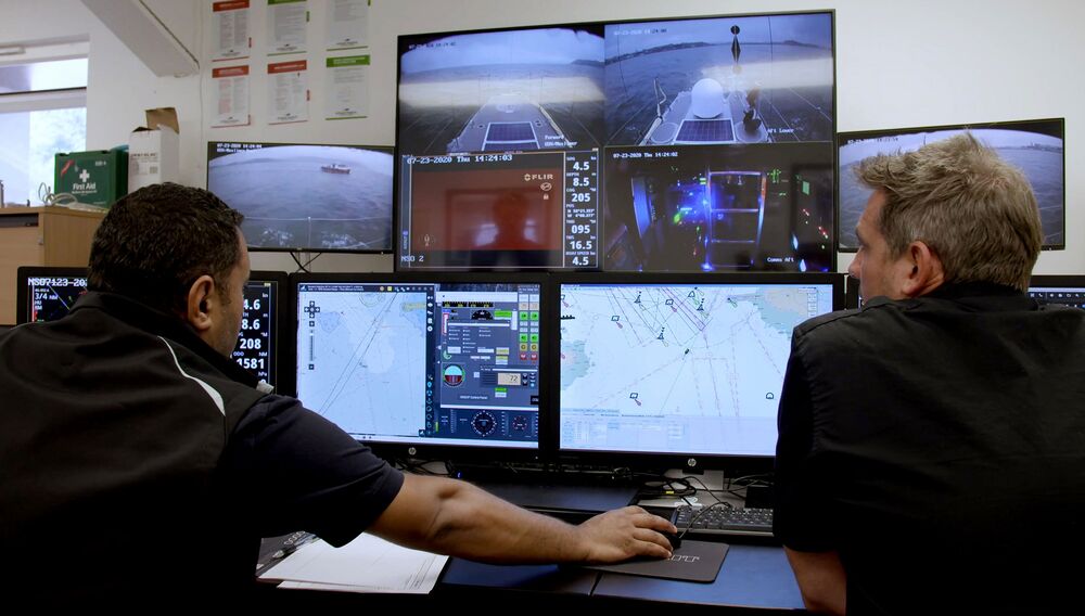
The Remote Operations Centre at Sea-Kit’s base in Tollesbury, England.
The Sea-Kit team is remotely controlling and monitoring the Maxlimer at sea.
Photographer: Rich Edwards, Enp Media
The Sea-Kit team is remotely controlling and monitoring the Maxlimer at sea.
Photographer: Rich Edwards, Enp Media
The ISA is grappling with how to fairly distribute wealth from international waters and protect the poorly understood ecosystems of the deep ocean.
“The law of the sea was written on the idea that if you use something that belongs to everybody, it’s equally shared,” says Marzia Rovere, a marine geologist at the Institute of Marine Sciences in Bologna, Italy, who’s been working on the UN framework.
“How to do this—it’s still a matter of debate.”
For centuries, sailors have sought to measure the ocean’s depth as a way to gauge the approaching shore and gain a better understanding of the topography.
Until the early 20th century, the technology was simple: a weight and a long rope.
The Challenger expedition in the 1870s used such sounding lines for a four-year trip that sought to map the seabed and catalog creatures in various parts of the ocean; it discovered the Mariana Trench, home to what’s now called the Challenger Deep, at more than 35,000 feet the deepest known part of the ocean.
After the Titanic sank in 1912, explorers proposed using sound waves to find its hull in the North Atlantic, accelerating the development of sonar, the most common technique used today.
Using the Sea-Kit Maxlimer, GEBCO-NF, a 14-nation team let by Rochelle Wigley and Yulia Zarayskaya, last year won the Ocean Discovery XPrize, netting $4 million in the competition aimed at nurturing technologies for mapping the seabed.
Other groups submitted ideas such as deploying multiple robots to map an area quickly, dropping retrievable pods from drones, and using lasers to determine the shape of the terrain.
The XPrize judges said a key differentiator for Sea-Kit was the way it tapped cloud technology to process data and create a detailed map in a tight, 48-hour window.
Corporations are also starting to study the ocean’s depths.
Ocean Infinity, based in Austin, does surveys for the oil industry with robots that can map terrain 20,000 feet below the surface.
International Business Machines Corp. is working with marine researcher Promare to build the Mayflower Autonomous Ship, which next year will attempt an Atlantic crossing guided by artificial intelligence.
Fugro NV, a Dutch company that also serves energy producers, has been developing similar mapping technologies—and this year it bought two of Sea-Kit’s boats and invested in the company.
Teledyne Caris and researchers this summer analyzed the 1.5 billion data points the Maxlimer gathered.
Schools of fish, temperature changes, and the drop-off of an underwater canyon can muddy the information coming back from the sonar; until recently, sorting through those anomalies to build an accurate map took an hour of computer time for every hour spent collecting data.
AI has cut that to less than 10 minutes.
Those are the kinds of advances needed to reach the goal of mapping the entire ocean, says Jyotika Virmani, who was executive director of the XPrize.
With that information in hand—and available to the public, as envisioned by Seabed 2030—scientists will better understand, say, where a tsunami might hit, how much sea levels might rise because of climate change, and potential shifts in ocean currents as temperatures climb.
“It works to everyone’s advantage to get this information out,” says Virmani, who now runs the Schmidt Ocean Institute, established by former Google head Eric Schmidt.
“Once we know what’s there in its entirety, we can really truly start to figure out what’s what on this planet.”
Links :
- GeoGarage blog : One-fifth of Earth's ocean floor is now mapped / Mappers look to chart world's ocean floor by 2030 / An ambitious project aims to map the entire ocean floor. It ... / Earth's final frontier: the global race to map the entire ocean floor / Robots ahoy! Mapping Earth's surface / Underwater drones nearly triple data from the ocean floor / Ocean floor to be mapped by 2030 / Teams autonomously mapping the depths ...
- TheNextWeb : MIT’s new autonomous boat ruled Amsterdam’s canals for 3 hours
- Martime Executive : Techno Pilgrims
No comments:
Post a Comment