Tuesday, December 7, 2010

Open Boat Orchestra, music created by sailing


OBO (Open Boat Orchestra) Generation 1 playing a file from the Artemis IMOCA 60 during the Sevenstar Round Britain Race July 2010.
The venue on this occasion was Richard's Tinley's work bench at Tinley Marine Electronics in Lymington.
Shot by film-maker Richard Gooderick with sound recorded by Mark Ty-Wharton.

From Lia Ditton website

What if a state-of-the-art race boat could be transformed into a live, digital orchestra?
What sounds would be created from the force of wind and water on its sail and keel, and by even the smallest of adjustments of its skipper?
How would this music change over the course of an oceanic race?
And what if this soundtrack could be heard and mixed live by audiences around the globe?
These questions form the basis for Open Boat Orchestra or
OBO, the latest project from 30 year-old British artist and professional sailor Lia Ditton: using real-time data from a sail boat to create a unique experience in sound.

The idea originated in 2003 while Lia Ditton was watching the America’s Cup live on TV:
‘When the boat tacked, the bow moved through the wind so quickly and with such precision that the jib went flunk. The second sound was grrrhhhr. The main wasn’t being trimmed. It was trimmed: one single action, one sound bite!’ She recalls. Inspired by this and other sounds coming from the boat, the idea has since evolved into a full-blown project: translating one of the world’s most dynamic ocean races into the universal language of music.

Open Boat Orchestra (OBO) will play out on the international stage of the
Transat Jacques Vabre race which begins in November 2011.
The experimental edge to OBO lies in the unpredictability of how the boat will ‘play.’
In this respect, every stage of the race will become as much a work of music as an adventure under sail, subject to the forces of nature.

“We can’t entirely predict what the angle of the wind versus the speed of a boat through the water as it crashes off a wave will sound like; how one variable could audibly relate to a sequence of others. There could be periods of time, for example, especially in a rough North Atlantic where the music is loud and vivacious, while in the relative calm of the South Atlantic the music is wonderfully andante! What excites me as a sailor is that we might be able to optimize a boat’s performance beyond what it is possible to see and feel, by listening into the music as it is being created.”

How it works ?

Neither the sails nor anything else onboard will make an actual sound.
The sounds will instead be created digitally, using data streamed in real-time from the marine electronic instruments (
NMEA0183 output).
However, the data generated by the boat, also does not produce sine waves or audible sound.
The data streams are what control an ensemble of pre-selected instrumental sounds.
The boat moving through the water is thus the
synthesizer.

Defining exactly how many data elements are preferred to work with, what kind of function they should perform and then building the mechanics of how the data will control sound, patterns, tempo, key, etc. is the challenge.

The note, pitch and sound range of each source of monitored data will also be assigned, so that when all the different elements of the data stream ‘play’ together, they sound harmonic.
Each ‘instrument’ could be paired with a speed variable – boatspeed, SOG, or windspeed to determine volume, for example.

The music of OBO will be a blend of World influences.
As the boat races non-stop around the world, the sounds assigned to the load cell instruments will change according to a GPS trigger.
Down the Atlantic past Brazil, for example, OBO music will draw in the sounds of instruments native to Brazil; when the boat sails into the longitude of Africa, African instrumental sounds and rhythms will be brought into the orchestra.

What are we expecting to see as OBO completes its voyage?
We anticipate stronger winds and rougher seas to generate more extreme data readings and therefore more dynamic music, while in calmer seas the audio should be calmer and much softer.

Will fine-tuning the boat according to its music, also optimize the boat’s sailing performance?

“What excites me as a sailor, is that we might be able to optimize the boat’s racing performance beyond what it is possible to see and feel, by listening into the music as it is being created. We should be able to hear if there is too much backstay or head-stay tension, for example and so be able to trim the boat accordingly.” Lia Ditton.

Links :

Monday, December 6, 2010

NZ Linz update in the Marine GeoGarage


6 charts have been updated in the Marine GeoGarage (Linz october update published November 9, 2010) :

  • NZ 46 : Cook Strait
  • NZ 76 : Western Approaches to Foveaux
  • NZ 865 : Approaches to Apia
  • NZ 4633 : Wellington Harbour
  • NZ 6821 : Bluff Harbour and Entrance : Port of Bluff
  • NZ 8655 : Apia Harbour
Today NZ Linz charts (178 charts / 340 including sub-charts) are displayed in the Marine GeoGarage.

Note : LINZ produces official nautical charts to aid safe navigation in New Zealand waters and certain areas of Antarctica and the South-West Pacific.
Using charts safely involves keeping them up-to-date using Notices to Mariners

Brazil DHN update in the Marine GeoGarage


8 charts have been updated on the Marine GeoGarage (10-11-25 DHN update) in the set of 226 charts :

  • 200 : DA ILHA DE MARACÁ À ILHA DO MACHADINHO
  • 201 : BARRA NORTE DO RIO AMAZONAS
  • 210 : PROXIMIDADES DA BARRA NORTE DO RIO AMAZONAS
  • 220 : DA BARRA NORTE AO PORTO DE SANTANA
  • 2100 : DE MOSTARDAS AO RIO GRANDE
  • 2101 : PORTO DO RIO GRANDE
  • 2110 : PROXIMIDADES DO PORTO DE RIO GRANDE
  • 2112 : DE RIO GRANDE A FEITORIA

Canada CHS update in the Marine GeoGarage


28 charts
have been updated for Canada (CHS update published November 30, 2010) :

1431 : CANAL DE BEAUHARNOIS - LAC SAINT-LOUIS TO SAINT FRANCOIS
1510A : LAC DES DEUX MONTAGNES
1510B : LAC DES DEUX MONTAGNES
1550 : BRITANNIA BAY TO CHATS FALLS
1552B : CHUTE DU GRAND CALUMET TO LAC COULONGE
2235 : CAPE HURD TO LONELY ISLAND
2251 : MELDRUM BAY TO ST. JOSEPH ISLAND
2282 : OWEN SOUND TO CABOT HEAD
2283A : OWEN SOUND TO GIANTS TOMB ISLAND
2283B : SOUTHERN GEORGIAN BAY - INSETS OF CHART 2283
3441 : HARO STRAIT BOUNDARY PASS AND SATELLITE CHANNEL
3462 : JUAN DE FUCA STRAIT TO STRAIT OF GEORGIA
3742 : OTTER PASSAGE TO McKAY REACH
3743 : DOUGLAS CHANNEL
3802 : DIXON ENTRANCE
4023 : NORTHUMBERLAND STRAIT
4141A : SAINT JOHN TO EVANDALE
4141B : GRAND BAY TO EVANDALE INCLUDING BELLEISLE BAY
4381 : MAHONE BAY
4406 : TRYON SHOALS TO CAPE EGMONT
4425 : HARBOURS ON THE NORTH SHORE
4447 : POMQUET AND TRACADIE HARBOURS
4448 : PORT HOOD
4462 : ST. GEORGE'S BAY
4523 : LIITLE BAY ARM AND APPROACHES
4585 : GREEN HEAD TO LITTLE BAY ISLAND
4905 : CAPE TORMENTINE TO WEST POINT
4950 : ILES DE LA MADELEINE
6267 : GRINDSTONE POINT TO BERENS RIVER
7736 : SIMPSON STRAIT
7777 : CORONATION GULF WESTERN PORTION

So 692 charts (779 including sub-charts) are available in the Canada CHS layer. (see coverage)

Note : don't forget to visit 'Notices to Mariners' published monthly and available from the Canadian Coast Guard both online or through a free hardcopy subscription service.
This essential publication provides the latest information on changes to the aids to navigation system, as well as updates from CHS regarding CHS charts and publications.

USA NOAA update in the Marine GeoGarage


13 charts
have been updated in the Marine GeoGarage (NOAA update 11/30/2010)

50 : NORTH PACIFIC OCEAN EASTERN PART
11326 : GALVESTON BAY
11480 : CHARLESTON LIGHT TO CAPE CANAVERAL
11486 : ST AUGUSTINE LIGHT TO PONCE DE LEON INLET
11502 : DOBOY SOUND TO FERNANDINA
12214 : CAPE MAY TO FENWICK ISLAND
12327 : NEW YORK HARBOR
12332 : RARITAN RIVER RARITAN BAY TO NEW BRUNSWICK
16710 : ORCA BAY AND INLET CHANNEL ISLANDS TO CORDOVA
18456 : OLYMPIA HARBOR AND BUDD INLET
18764 : SAN CLEMENTE ISLAND PYRAMID COVE AND APPROACHES
18765 : APPROACHES TO SAN DIEGO BAY
19004 : HAWAIIAN ISLANDS

Today
1019 NOAA raster charts (2932 including sub-charts) are included in the Marine GeoGarage viewer.

Note : NOAA updates their nautical charts with corrections published in:
- U.S. Coast Guard Local Notices to Mariners (
LNMs),
- National Geospatial-Intelligence Agency Notices to Mariners (
NMs), and
- Canadian Coast Guard Notices to Mariners (
CNMs)
While information provided by this Web site is intended to provide updated nautical charts, it must not be used as a substitute for the United States Coast Guard, National Geospatial-Intelligence Agency, or Canadian Coast Guard Notice to Mariner publications

Please visit the
NOAA's chart update service for more info.

Climate change: Met Office halves 'worst case' sea level prediction


Global inundation analysis model (Credit : CReSIS)

From TheTelegraph

The
Met Office has halved its "worst case" prediction for rising sea levels, in the latest instance of scientists being caught out for overstating the possible consequences of global warming.

Previously scientists had said oceans could rise by up to 13ft (4m) threatening cities like Shanghai, London and New York by 2100.
But it has been revised so that now the worse case scenario is just over 6ft 6in (2m).

This is still unlikely, but would mean the Maldives in the Indian Ocean and Tuvalu in the Pacific could be lost forever.
The most likely sea level rise this century remains between 8 and 23 inches (20-60cm), causing devastation in small island states and low lying countries like Bangladesh.

The report also found that the Atlantic
Conveyor belt is not slowing down as much as previously thought.
The circulation of currents, also known as the Gulf Stream, keeps Britain warm and it was feared that if it slows down suddenly it could cause a ‘second ice age’.

The scenario was used in the
Day After Tomorrow film and has even been blamed for the recent cold snaps, but it appears it is unlikely to affect Britain this century.
The revisions will be pounced on by sceptics as evidence that the Met Office has exaggerated climate change, especially after the debacle over last year's washout "barbecue summer"

However
Vicky Pope, head of climate change advice, pointed out that overall the report found that most global warming predictions are the same or worse than previously thought.
“The evidence of the dangerous impacts of climate change is now clearer than ever,” she said.
The report looked at all the recent peer-reviewed papers on climate change on behalf of the UK Government.

The idea was to reassess the threats since the last major study on global warming was carried out by the United Nations science body, the Intergovernmental Panel on Climate Change (
IPCC), in 2007.

It found that the melting of the Arctic is happening faster than thought, with ice free summers expected by the middle of this century.
Also deforestation could speed up as droughts in the Amazon cause massive forest fires.
It found that other dangerous ‘feed backs’ such as the methane released by thawing permafrost or wetlands is more likely as more evidence emerges.

“In most cases our new understanding has reinforced the last major study in 2007 – the degree of impact is about the same. In some cases our understanding leads us to conclude that the risks are greater,” added Dr Pope.

The report was launched at the
UN Cancun Climate Change talks to highlight the threat of global warming.
More than 190 countries are gathered in the luxury resort in Mexico to decide the best way to stop global warming.

However the talks are at a deadlock at the moment as countries are failing to decide the best way to cut emissions.
Countries remain at loggerheads over whether to continue the
Kyoto Protocol, which is the only existing agreement on global warming, or start again with a new legal treaty.

Chris Huhne, the Energy and Climate Change Secretary, is flying out to try and find a middle ground.
He insisted the talks are on track to an eventual legal treaty to stop global warming.
“The mood has been cautiously positive. People are talking. The show is on the road,” he said.
“But it is not enough. If we are to meet our objectives and lay the groundwork for a binding deal, week two must bring more urgency, more compromise, and more commitment.”

Links :
  • DailyMail : Alarmist Doomsday warning of rising seas 'was wrong', says Met Office study
  • TheIndependent : Rising sea level threatens 'hundreds' of Caribbean resorts, says UN report
  • TheGuardian : Don't consign us to history, plead island states at Cancún
  • NYTimes : As glaciers melt, science seeks data on rising seas

Sunday, December 5, 2010

“No fish left behind” approach leaves Earth with nowhere left to fish


Meet Rupert Howes.
Influenced by conservationists like David Attenborough, Rupert Howes was determined to make the world more sustainable.
His financial training and experience with nonprofit organizations convinced him "we must work with the grain of the market to shift our economic system to a more sustainable footing" to create a world that operates within ecological limits.
As CEO of Marine Stewardship Council (MSC), he focuses on reversing the decline in global fish stocks through MSC's marine certification and eco-labeling programs.

From University of British Columbia

A new study finds that Earth has run out of room to expand fisheries

The Earth has run out of room to expand fisheries, according to a new study led by
University of British Columbia researchers that charts the systematic expansion of industrialized fisheries.

In collaboration with the
National Geographic Society and published today in the online journal PLoS ONE, the study is the first to measure the spatial expansion of global fisheries.
It reveals that fisheries expanded at a rate of one million sq. kilometres per year from the 1950s to the end of the 1970s.
The rate of expansion more than tripled in the 1980s and early 1990s – to roughly the size of Brazil’s Amazon rain forest every year.

Between 1950 and 2005, the spatial expansion of fisheries started from the coastal waters off the North Atlantic and Northwest Pacific, reached into the high seas and southward into the Southern Hemisphere at a rate of almost one degree latitude per year.
It was accompanied by a nearly five-fold increase in catch, from 19 million tonnes in 1950, to a peak of 90 million tonnes in the late 1980s, and dropping to 87 million tonnes in 2005, according to the study.

“The decline of spatial expansion since the mid-1990s is not a reflection of successful conservation efforts but rather an indication that we’ve simply run out of room to expand fisheries,” says
Wilf Swartz, a PhD student at UBC Fisheries Centre and lead author of the study.

Meanwhile, less than 0.1 per cent of the world’s oceans are designated as marine reserves that are closed to fishing.

“If people in Japan, Europe, and North America find themselves wondering how the markets are still filled with seafood, it’s in part because spatial expansion and trade makes up for overfishing and ‘fishing down the food chain’ in local waters,” says Swartz.

“While many people still view fisheries as a romantic, localized activity pursued by rugged individuals, the reality is that for decades now, numerous fisheries are corporate operations that take a mostly no-fish-left-behind approach to our oceans until there’s nowhere left to go,” says
Daniel Pauly, co-author and principal investigator of the Sea Around Us Project at UBC Fisheries Centre.

The researchers used a newly created measurement for the ecological footprint of fisheries that allows them to determine the combined impact of all marine fisheries and their rate of expansion.
Known as
SeafoodPrint, it quantifies the amount of “primary production” – the microscopic organisms and plants at the bottom of the marine food chain – required to produce any given amount of fish.

“This method allows us to truly gauge the impact of catching all types of fish, from large predators such as bluefin tuna to small fish such as sardines and anchovies,” says Pauly. “Because not all fish are created equal and neither is their impact on the sustainability of our ocean.”

“The era of great expansion has come to an end, and maintaining the current supply of wild fish sustainably is not possible,” says co-author and National Geographic Ocean Fellow
Enric Sala. “The sooner we come to grips with it – similar to how society has recognized the effects of climate change – the sooner we can stop the downward spiral by creating stricter fisheries regulations and more marine reserves.”

Links :

Saturday, December 4, 2010

Submarine cables : how the net connected the world

In 1998, just a handful of countries had extensive internet usage.
Today, nearly two billion people have web access via
submarine communication cables
Click on : http://www.bbc.co.uk/news/technology-11864350
Then move the slider below to see how the cable network has spread and internet use has expanded
.

From TheAtlantic

The Internet is where we live our digital lives. But it's also a physical network of cables that span the globe.

We've clearly come a long, long way since the
first trans-Atlantic telegraph cable, which was laid in 1858 between the United States and Great Britain.
Last week, we were lucky enough to have
Hal Wallace, the electricity curator at the National Museum of American History walk us through the story of that very first submarine line.

The line was the brainchild of the financier
Cyrus Field.
He had a stunningly simple plan. Take one British warship and one American frigate, load them up with cable, and navigate them towards each other.
There was nothing fancy about the cable laying process: they just paid out the cable over the back and let it sink into the depths.
When the British and American vessels met up, they spliced the cable together and were in business. You can see the apparatus
here, thanks to Atlantic-Cable's sleuthing.

Map of the 1858 trans-Atlantic cable route


Sadly, the first cable didn't last long.
After three weeks, it stopped working and was never reconnected.
"The operators didn't realize how to work a cable like this," Wallace said. "The signal was very weak, so the answer was, 'More Power Scotty' and they fried the cable."
By the time they laid the more permanent telegraph lines in the 1860s, operators had learned their lesson.


There's a fascinating coda to the story, too.
Contemporary interest in the submarine cable was huge.
In fact, there was a short-lived frenzy after the connection was initially made.
Field, ever the entrepreneur, entered into a deal with Tiffany's to sell chunks of the cable as souvenirs.
So, what you're looking at the top of this post is a Tiffany's branded chunk of submarine cable.
It even came with a certificate of authenticity from Field himself.
The moral of the story? Don't let anyone tell you that technological enthusiasm is something new.
Links :

Friday, December 3, 2010

Oceans failing the acid test, U.N. says


Rob Dunbar hunts for data on our climate from 12,000 years ago, finding clues inside ancient seabeds and corals.
His work is vital in setting baselines for fixing our current climate -- and, scarily, in tracking the rise of deadly ocean acidification.


From CNN

The chemistry of the world's oceans is changing at a rate not seen for 65 million years, with far-reaching implications for marine biodiversity and food security, according to a new United Nations study released Thursday.

"
Environmental Consequences of Ocean Acidification," published by the U.N. Environmental Program (UNEP)," warns that some sea organisms including coral and shellfish will find it increasingly difficult to survive, as acidification shrinks the minerals needed to form their skeletons.

Lead author of the report
Carol Turley, from the UK's Plymouth Marine Laboratory said in a statement: "We are seeing an overall negative impact from ocean acidification directly on organisms and on some key ecosystems that help provide food for billions. We need to start thinking about the risk to food security." (video)

Tropical reefs provide shelter and food for around a quarter of all known marine fish species, according to the U.N. report, while over one billion people rely on fish as a key source of protein.
Ocean acidification is yet another red flag being raised, carrying planetary health warnings about the uncontrolled growth in greenhouse gas emissions

Increasing acidification is likely to affect the growth and structural integrity of coral reef, the study says, and coupled with ocean warming could limit the habitats of crabs, mussels and other shellfish with knock-on effects up and down the food chain.

The report, unveiled during the latest round of U.N. climate talks in Cancun, Mexico, says that around a quarter of the world's CO2 emissions are currently being absorbed by the oceans, where they are turned into carbonic acid.

Overall, pH levels in seas and oceans worldwide have fallen by an average of 30 percent since the Industrial Revolution. The report predicts that by the end of this century ocean acidity will have increased 150 percent, if emissions continue to rise at the current rate.

But scientists say there may well be winners and losers as acidification doesn't affect all sea creatures in the same way.
Adult lobsters, for example, may increase their shell-building as pH levels fall, as might brittle stars -- a close relation of the starfish -- but at the cost of muscle formation.
"The ability, or inability, to build calcium-based skeletons may not be the only impact of acidification on the health and viability of an organism: brittle stars perhaps being a case in point," Turley said in a statement.

"It is clearly not enough to look at a species. Scientists will need to study all parts of the life-cycle to see whether certain forms are more or less vulnerable."

Scientists are more certain about the fate of photosynthetic organisms such as seagrasses, saying they are likely to benefit from rising acidification and that some creatures will simply adapt to the changing chemistry of the oceans.

The authors identify a range of measures which policymakers need to consider to stop pH levels falling further, including "rapid and substantial cuts" to CO2 emissions as well as assessing the vulnerability of communities which rely on marine resources.

"Ocean acidification is yet another red flag being raised, carrying planetary health warnings about the uncontrolled growth in greenhouse gas emissions. It is a new and emerging piece in the scientific jigsaw puzzle, but one that is triggering rising concern,"
Achim Steiner, UNEP executive director, said in a statement.

Links :
  • TheTelegraph : Cancun climate summit, Britain's salmon at risk from ocean acidification
  • Reuters : Ocean acidification may threaten food security
  • AFP : UN report highlights ocean acidification
  • Wired : Ocean acidification gives young fish a death wish
  • Blog GeoGarage : Ocean acidification, the other CO2 issue

Thursday, December 2, 2010

Watson ready on Antarctic whale defense campaign to confront the hunt


From TheJapanTimes

Sea Shepherd antiwhaling activist Paul Watson said Friday his group is prepared for this year's campaign against Japanese whaling near Antarctica and he rejects the conclusions of New Zealand's investigation into a collision at sea earlier this year.

Speaking in Sydney, Watson, founder of the Sea Shepherd Conservation Society, said this season's antiwhaling campaign, dubbed "
Operation No Compromise," is already on.

"We're better equipped now than ever before. Every year the Japanese whaling fleet gets weaker (and) we get stronger," he said, insisting his group's upcoming campaign will fare better than last year's.


'Gojira' Ocean Adventurer replacing former 'Ady Gil'

Watson said the new fast interceptor vessel Ocean Adventurer, currently in Fremantle, Western Australia, will join the former Norwegian harpoon vessel Bob Barker in Hobart, Tasmania, along with the flagship vessel Steve Irwin, which is currently en route to the southern city, the closest point to the Southern Ocean.

All three vessels, with about 80 crew members, will set sail on Dec. 2 to confront the Japanese whalers in Antarctic waters, he said, adding that he expects the Japanese fleet to leave Japan any day now and arrive in Antarctic waters around Dec. 18.

Watson said he believes the whalers will be more assertive this coming season.

"Australia and New Zealand have virtually given the green light to (Japan to) be more aggressive by doing nothing," he said in regard to an incident last January in which the whaling vessel
Shonan Maru No. 2 chopped off the bow of Sea Shepherd's New Zealand-registered speedboat the Ady Gil, which later sank.

Watson also said he disagrees with the findings contained in New Zealand maritime authorities' investigation report released Wednesday, in which both parties were blamed for the collision. "I think New Zealand is trying to sit on the fence here and keep everybody happy by saying both people are at fault," he said.

"The report admits the Ady Gil had the right of way, it admits the Shonan Maru was the overtaking vessel, it admits the Shonan Maru should have avoided the collision and it admits the Shonan Maru deliberately turned into the Ady Gil — and then it says they are only 50 percent responsible for the collision, which seems very strange for me," he said.


The report also found that the 16-ton Ady Gil failed to maintain an effective lookout and failed to respond appropriately once the collision risk was apparent, choosing instead to maintain course and speed.

Watson said that even though the incident was perhaps the most documented collision in maritime history, the investigation can hardly be called conclusive in the absence of the Japanese government's cooperation and that of the Shonan Maru No. 2 captain.

When asked whether special steps will be taken by Sea Shepherd to prevent a similar incident, he merely said, "We're prepared for them to be more aggressive, we're prepared to disrupt their operations as efficiently as we can."

Currently doing fundraising work in Australia before heading to Hobart to board the Steve Irwin, Watson believes his group is on the right track.

"Over the past five years, we've cut their profits, we're speaking the language they understand, they're $200 million in debt on subsidy loans to the Japanese government and we've saved over 2,000 whales from being killed, so I think we're having an impact."

Links :
  • BBC : whaling collision 'fault of both sides'
  • CSMonitor : Japan's 'scientific' whaling season delayed, Sea Shepherd claims responsibility

Wednesday, December 1, 2010

A world redrawn : when America showed up on a map, it was the universe that got transformed

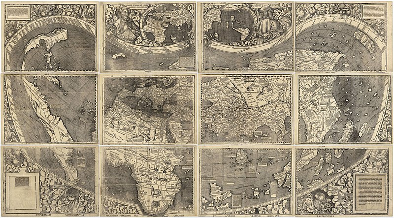
Universalis Cosmographia, the Waldseemüller wall map dated 1507,
depicts the Americas, Africa, Europe, Asia, and the Pacific Ocean separating Asia from the Americas
(full resolution)

From BostonGlobe

NEARLY FIVE CENTURIES ago, the Polish astronomer Nicholas Copernicus went public with one of the most important arguments ever made in the history of ideas.
The earth did not sit immobile at the center of the universe, he wrote.
It revolved around the sun.

It was the mother of all paradigm shifts, dismantling a model of the universe that had been dogma since antiquity.
When he published his theory, in “On the Revolutions of the Heavenly Spheres” (1543), Copernicus provided a wealth of data on the movements of celestial bodies in support of his case. But what’s often overlooked is that he began his argument from the ground up, by focusing not on the heavens but the earth.
In particular, he began with a geographical revelation, prompted by something he had recently come across on a new map.

Known today as the Waldseemüller map of 1507, it was the first to depict the lands discovered by Columbus and other early explorers as part of a vast and previously unknown continent.
Earlier maps had shown the new discoveries only vaguely, as a still-to-be-determined part of Asia, but this new map boldly located them far out in the western ocean, on the other side of the globe from the known world, extending deep into the southern hemisphere.
And it gave this place a memorable new name: America.

The story of how a map of the world helped Copernicus to rethink the universe is rarely told. But the connection tells us something important about how great ideas are born.
To understand it, we need to recall that medieval scholars didn’t consider geography and astronomy to be distinct disciplines.
Instead, they considered them parts of a single field called cosmography - the study of the known world and its place in the cosmos.
One of the field’s guiding principles went something like this: Looking down, we see up; looking up, we see down.
By carefully studying the earth, cosmographers believed they could learn about the heavens, and by carefully studying the heavens they believed they could learn about the earth.
Copernicus himself was a cosmographer, and shared this view.

We remember Copernicus as one of the first great thinkers of the modern scientific era, but he inhabited a profoundly medieval thought-world - a world in which astrology and alchemy commanded as much attention as geography and astronomy.
For all its obvious and sometimes laughable shortcomings, the medieval approach to learning was far more integrated than our own, and it allowed Copernicus to think on a truly grand scale.
From a cosmic vantage point he looked down, at a map, and what he saw made the skies open up.

WHEN CHRISTOPHER COLUMBUS first sailed west from Spain in 1492 in search of the Indies, nobody worried that he would sail off the edge of the earth.
Medieval Europeans knew full well that the world was a sphere, and that if you sailed far enough to the west you would arrive in the east.

In that sense, they understood the shape of the world.
But when they set their sights beyond the earth, they still relied on a 2,500-year-old model of the universe, one that scholastics during the Middle Ages had made fundamental to Christian theology.
According to teachings that dated to Aristotle, the cosmos as a whole consisted of a set of concentric spheres.
At the center was the earth, a solid ball of land.
Surrounding the earth, successively, were spheres of water, air, and fire; then individual spheres for the moon, the sun, and the planets; and finally, at the outer limits, a single sphere studded with stars, beyond which lay a realm of pure abstraction, or God.
Each of these celestial spheres rotated around the earth at its own pace.

This model did a serviceable job of explaining the apparent motions of the heavens, but it had a fundamental problem.
If the cosmos did indeed consist of a set of spheres with the earth at its center, then why wasn’t the earth completely submerged in the sphere of water that surrounded it?
Why was there any exposed land at all?

European scholars in the late Middle Ages devised a way of explaining this problem away.
The earth, they suggested, bobbed slightly off-center in the sphere of water, “like an apple in a basin,” as one writer put it in 1484.
How had this happened? God had simply made it so. The Book of Genesis told the story: “And God said, Let the waters under the heaven be gathered together unto one place, and let the dry land appear.”
In practical terms, scholars explained, what God had done in working this miracle was to push the sphere of the earth to one side of the sphere of the water, exposing part of it to the air and creating the contiguous lands that would come to be known as Asia, Europe, and Africa.

Copernicus knew the theory of the off-center earth well from his student days.
But he didn’t buy it.
Mathematically, geometrically, logically - it just didn’t make sense to him.
Anybody could see that the earth’s landmass didn’t gradually and uniformly mount upward from the sea toward a high point somewhere in the middle of the known world, as this model suggested it should.
“Furthermore,” he wrote in the geographical section with which he opened On the Revolutions, “the depth of the abyss would never stop increasing from the shore of the ocean outward, so that no island or reef or any form of land would be encountered by sailors on the longer voyages.”

But Copernicus went on to add that he had recently come across even more compelling evidence against this theory.
And this evidence can only have come from the Waldseemüller map.

The map was the work of Martin Waldseemüller, a German humanist based in the town of Saint-Die, in the mountains of eastern France.
It was this obscure figure, now almost completely forgotten, who first mapped the world roughly as we know it today.

Waldseemüller’s map was huge, measuring 4½ feet by 8 feet.
Probably no printed map had ever been larger.
Waldseemüller would later claim that he printed 1,000 copies of the map, but only one survives today, discovered by accident in a German castle in 1901, and bought in 2003 by the Library of Congress for $10 million, the highest price ever paid publicly for a historical document.

Copies of the map seem to have circulated widely in the early 16th century.
In the years immediately after 1507, it reached a number of German university towns, where professors probably used it as a classroom prop.
By 1512, it had made it to Poland, where Jan de Stobnicza, a professor of philosophy at the University of Krakow, published his own partial copy.

Nobody who saw the map could miss what dominated its left side.
Rising majestically out of the western ocean, extending deep into the southern hemisphere, was a huge new continent.
And printed across the region we now know as Brazil was a strange new name: America.

Waldseemüller and his colleague Matthias Ringmann wrote a companion volume to the map, in which they explained the nature and location of this new continent, and why they had named it America.
Europeans, they wrote, had long divided the world into three parts: Asia, Europe, and Africa.
But recent developments, most notably voyages made by the Italian merchant Amerigo Vespucci, meant that this old picture of the world had to be updated.
“A fourth part [of the world],” they wrote, “has been discovered by Amerigo Vespucci … Since both Asia and Africa received their names from women, I do not see why anyone should rightly prevent this from being called…America, after its discoverer, Americus.”

Why Vespucci and not Columbus?
Columbus had restricted his explorations to the Caribbean, which, he insisted until his dying day, corresponded to a region already visible on maps of the Far East.
Vespucci, on the other hand, had done something much more dramatic.
He had sailed south, following the coastlines of the New World far below the equator into a part of the world never mapped before.

Waldseemüller decided to make his map after reading letters by Vespucci and seeing sailors’ charts containing sketches of the newly discovered coasts.
It was the southness, not the westness, of the New World that made him, like other Europeans, feel that something remarkable had been discovered across the Atlantic.

The logical thing for Waldseemüller to do would have been to depict these new coasts as a part of Asia, or at least as nothing more than terra incognita.
But instead he decided that what Vespucci had discovered had to be an entirely new continent.

At the time Copernicus came across the Waldseemüller map, he had already begun to look for evidence that would support his new theory of the cosmos.
And when he saw America on the map, he knew he had found what he was looking for.
The location of this new continent, he realized, disproved the theory of the off-center earth.

If the earth really did bulge out of one side of the sphere of water, he reasoned, then the ocean had to get deeper and deeper the farther one sailed away from the shores of the known world. Land, in other words, could not protrude from opposite sides of the sphere of water.
And yet that’s exactly what Copernicus saw happening on the Waldseemüller map.
Here was a giant southern continent far off in the western ocean, located diametrically opposite to the known world.

There was only one way to explain this oddity, Copernicus decided: The watery sphere must not exist at all. The earth and its oceans had to be one, and in that single globe there had to be much more earth than water.

Quite suddenly, at its very core, the old model of the cosmos was falling apart.
If the theory of an off-center earth was directly at odds with geographical reality, as the Waldseemüller map showed it to be, then the time had come, it seemed to Copernicus, to think about the cosmos from an entirely different perspective.

Perhaps it was not the heavens that were in motion, but the earth.

COPERNICUS DIDN’T MENTION the Waldseemüller map by name in On the Revolutions, but several different strands of evidence strongly suggest that he saw the map and used it to develop his theory of the cosmos.

In the preface to On the Revolutions, he mentioned having begun the book long before its 1543 publication, and having kept some version of it buried among his papers for “the fourth period of nine years.”
The phrase is convoluted, but the math is simple.
Four periods of nine years is 36 years, and 36 years before 1543 is 1507 - the year the Waldseemüller map appeared in print.
It’s easy to see how Copernicus could have had access to the map, too; he was in Poland during that period, visiting and corresponding with colleagues at the University of Krakow, where the map appeared no later than 1512.
Most convincing of all, however, is that in the opening section of On the Revolutions he describes the earth using language that corresponds directly to what appears on the Waldseemüller map.
His description of America, in particular, corresponds so precisely, in language and cartographical detail, that no other source appears possible.

As a cosmographer steeped in medieval ideas, Copernicus found his way easily to the idea that studying the makeup of the earth might help him discern the makeup of the universe.
Today scientific learning is vastly more specialized, and few thinkers dare leap so boldly between the tiny to the cosmic; there are just too many disciplinary borders to cross along the way.
But precisely that kind of leap is what gives rise to great discoveries, which almost never can be contained within any one discipline.
One only has to think of Einstein for an illustration of this lesson.
What helped him develop his grand theory of relativity - as the historian of science Peter Galison has explained in fascinating detail in “Einstein’s Clocks, Poincaré’s Maps” - was the time he spent early in his life as a patent clerk, studying the problem of how to synchronize clocks.

Martin Waldseemüller and Matthias Ringmann both died decades before Copernicus published On the Revolutions, and never in their wildest dreams did they imagine that by putting America on the map they would help usher in an entirely new theory of the universe.
But nevertheless they recognized that they had created something revolutionary.
They even made a special plea on their map.
“This one request we have to make,” they wrote, “that those who are inexperienced and unacquainted with cosmography shall not condemn all this before they have learned what will surely be clearer to them later on.”

Links :