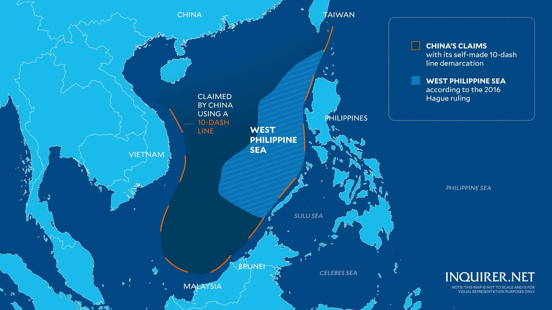
The Philippines will release soon a new map that will include the West Philippine Sea within its jurisdiction, the National Mapping and Resource Information Authority (Namria) said Friday.

A new Philippine map that includes the West Philippine Sea (WPS) as part of its jurisdiction will be released soon, the National Mapping and Resource Information Authority (Namria)
This map is not to scale and is for visual representation purposes only.
Graphics by: Samuel Yap / INQUIRER.net
This map is not to scale and is for visual representation purposes only.
Graphics by: Samuel Yap / INQUIRER.net
Speaking during a press conference in Malacañang, Namria Administrator Peter Tiangco said the map will be published after the implementing rules and regulations (IRR) for the newly signed Republic Act (RA) 12064, or the Philippine Maritime Zones Act, is released.
"We already have the maps prepared. We are just waiting for the implementing rules and regulations in order for us to modify or revise the maps we have prepared accordingly until its final publication," Tiangco said.
Asked to compare the new map with that one issued by China in August 2023, which incorporates Taiwan and most of the West Philippine Sea, Tiangco said: "The big difference here is that our map has a legal basis supported by existing laws."
Earlier on Friday, President Ferdinand Marcos Jr. signed the Philippine Maritime Zones Act that aims to declare the country's maritime zones in accordance with the standards set by the United Nations Convention on the Law of the Sea (Unclos).

The Maritime Zones Law uses the archipelagic baselines under the 2009 Philippine Baselines Law as the basis upon which the country's maritime zones are measured.
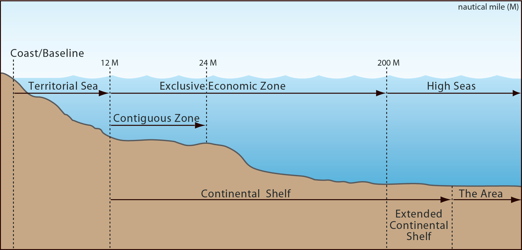
Apart from identifying the Philippine internal waters, the law also defines the archipelagic waters, full entitlement of a 12 nautical miles territorial sea, declaration of a 24 nautical miles contiguous zone from the baselines, and the 200 nautical miles exclusive economic zone and continental shelf where the Philippines can exercise sovereign rights and jurisdiction.
Apart from identifying the Philippine internal waters, the law also defines the archipelagic waters, full entitlement of a 12 nautical miles territorial sea, declaration of a 24 nautical miles contiguous zone from the baselines, and the 200 nautical miles exclusive economic zone and continental shelf where the Philippines can exercise sovereign rights and jurisdiction.

During the same press briefing, Sen. Francis Tolentino said the signing of the Philippine Maritime Zones Act was an enforcement of the 2016 arbitral ruling that invalidated China's massive claims in the South China Sea.
Tolentino, who sponsored the measure in the Senate, also expressed elation over the enactment of the law as well as the Philippine Archipelagic Sea Lanes Act.
He said the newly inked law would also mean "legislating the West Philippine Sea."
Philippines EEZ in the GeoGarage platform

NAMRIA including outer limits of the Extended Continental Shelf in the Benham Rise Region
Links :
- AP : Philippine president angers China with new laws to demarcate South China Sea territories
- Reuters : China opposes new Philippine maritime law, vows to protect South China Sea 'sovereignty'
- The Inquirer : PH affirms maritime zones, angering China
- ABC news : Philippine president signs new laws to secure sea territory, clashing with China
- OneNews : Marcos Signs Laws Asserting Philippines’ Maritime Rights, Sovereignty
- PNA : NMC to take ‘coherent, cohesive’ approach in maritime concerns
- Maritime Executive : China Angered by the Philippines' New Maritime Laws / Indonesia's New Leader Accidentally Boosts China's Maritime Claims
- SlideShare : The South China Sea West Philippine Dispute Justice Antonio T. Carpio Philippine Social Science Center / Carpio, Aquino regime disseminated spurious EEZ maps / Lopez Museum Historical Facts and Historical Lies in the West Philippine Sea (Updated)
- Shadow1 expedition : The Philippine Territorial Boundaries
- Newsweek : China's new map cclaims territory disputed bu US Ally
- Philstar : Philippines accuses China of illegally mapping claims to Scarborough Shoal
- GeoGarage blog : Ancient maps and the rise of a nation / The Philippine maritime zones


AMTI CSIS : The influence of the Philippine Archipealagic Sea Lanes Act on navigation rights
ReplyDeleteAMTI CSIS : The influence of the Philippine archipelagic sea lanes on navigation rights
ReplyDeleteEuroAsia Review : Strengthening Sovereignty: Indonesia, Malaysia, And The Philippines’ United Front In South China Sea – Analysis
ReplyDelete