 Geography
of Ancient World (Puranic Dwipas) as described in Puranas.
Geography
of Ancient World (Puranic Dwipas) as described in Puranas.Jambu Dwipa is one of the seven Dwipa’s i.e.
Jambu Dwipa, Kusa Dwipa, Plaksa Dwipa, Puskara Dwipa, Salmali Dwipa, Kraunca Dwipa, Saka Dwipa as depicted in the above map; Source: The Geography of Puran By: S.M.
Ali, FNI
From GeoSpatialWorld by Dr Vipul Singh
The study of trade winds, monsoons, and cyclones piqued the curiosity of many explorers in the eighteenth and nineteenth centuries.
However, they were still apprehensive about the unexpected weather shift in the midst of the ocean.
The marine cartography and nautical charts have helped humans comprehend the oceans and weather in several ways.
In the seventeenth century, ocean currents had a significant impact on South America’s colonisation.
To sail to their colonies in South America, Spanish and Portuguese navigators kept meticulous charts and maps.
The use of a compass and nautical charts transformed trips.
Some Spanish naval commanders learned how to use the wind’s force for marine navigation in the sixteenth century, even though they didn’t fully know how it worked.
These early Spanish and Portuguese expeditions immensely aided British navigators, who were very active in the Indian Ocean.
They also began maintaining wind records on their expeditions from the early seventeenth century.
The commanders of the ships started keeping a note of the trade wind direction, which was crucial for sailing, in the ship’s logbook.
However, monsoon winds continued to be the least understood winds, and for a very long period, their origin and nature were unknown.
In the latter half of the seventeenth century, as maritime trade between Europe and the Indian Ocean increased, navigators began to develop a better understanding of the monsoon.
Matthew Fontaine Maury, an American navigator, developed techniques to identify the prevalent wind patterns in 1855.
Using observation charts from more than a hundred ships in the Indian Ocean, Maurey was eventually able to produce the monsoon and trade wind map of the Indian Ocean at the request of the East India Company.
The Company believed that by developing wind and monsoon charts, the British fleet’s trip distance would be reduced, bringing down the cost of cargo shipping.
By the final decade of the eighteenth century, the British East India Company had already built observatories in the coastal regions of Madras, Bombay, and Calcutta.
Realizing that India has a climate significantly different from their own, they started making and documenting amateur meteorological observations.
A meteorological register that allowed for the daily recording of observations was created by Goldingham in 1793.
At all of the major observatories, including Madras, Bombay, Calcutta, Shimla, and Trivandrum, hourly meteorological observation started in 1848.
Even if these observatories were designed to explain the weather patterns in India, the colonial authority may have been more interested in solving the enigma of storms in the Indian Ocean, where much of its commercial activity depended.
The first ocean storms were noted by Henry Piddington in the Indian Ocean in 1839, and he was able to connect them to the name cyclone, which he invented after being inspired by a Greek word that meant snake coils.
In response to his observations of the ocean storms between 1839 and 1851, he wrote Sailor’s Handbook of Storms.
However, one of the difficulties during those years was finding skilled individuals to record the data.
The government didn’t start giving instructions to train two troops from each station until after 1856, but most of the time the work was handed to medical personnel who weren’t aware of the need for timeliness and accuracy of observations.
As a result, up until the middle of the nineteenth century, no modelling or forecasting could be done using meteorological information.
Due to the numerous tropical cyclones, the Bengal coast has historically been the most susceptible area in the Indian Ocean.
They often occur in October and November and bring extremely high winds, heavy rain, and storm surges that cause flooding and damage to standing crops in the eastern states of India.
Most often, they caused enormous harm to crop fields, moored ships, property, and the lives of people and animals.
The years 1831-85 saw some of the most severe storms ever recorded in nineteenth-century British chronicles.
Among these, the storm in 1864 wreaked immense destruction.
Both those moored at the coastlines and those in motion suffered damage.
Therefore, the British colonial scientists in India were eager to provide seasonal weather forecasts that may assist in the justification and expansion of the British empire.
In order to send out early warnings about impending storms, weather forecasting became crucial.
India provided a perfect natural laboratory for meteorology for meteorologists like Henry Blanford since it was more unpredictable than other places than the regularity of atmospheric and meteorological events.
Various navigators’ reports on the winds from throughout the world revealed that some regions of the oceans have consistent winds, named as trade winds.
The navigators discovered that if they put their ships in the normal trade winds’ courses, they could easily travel.
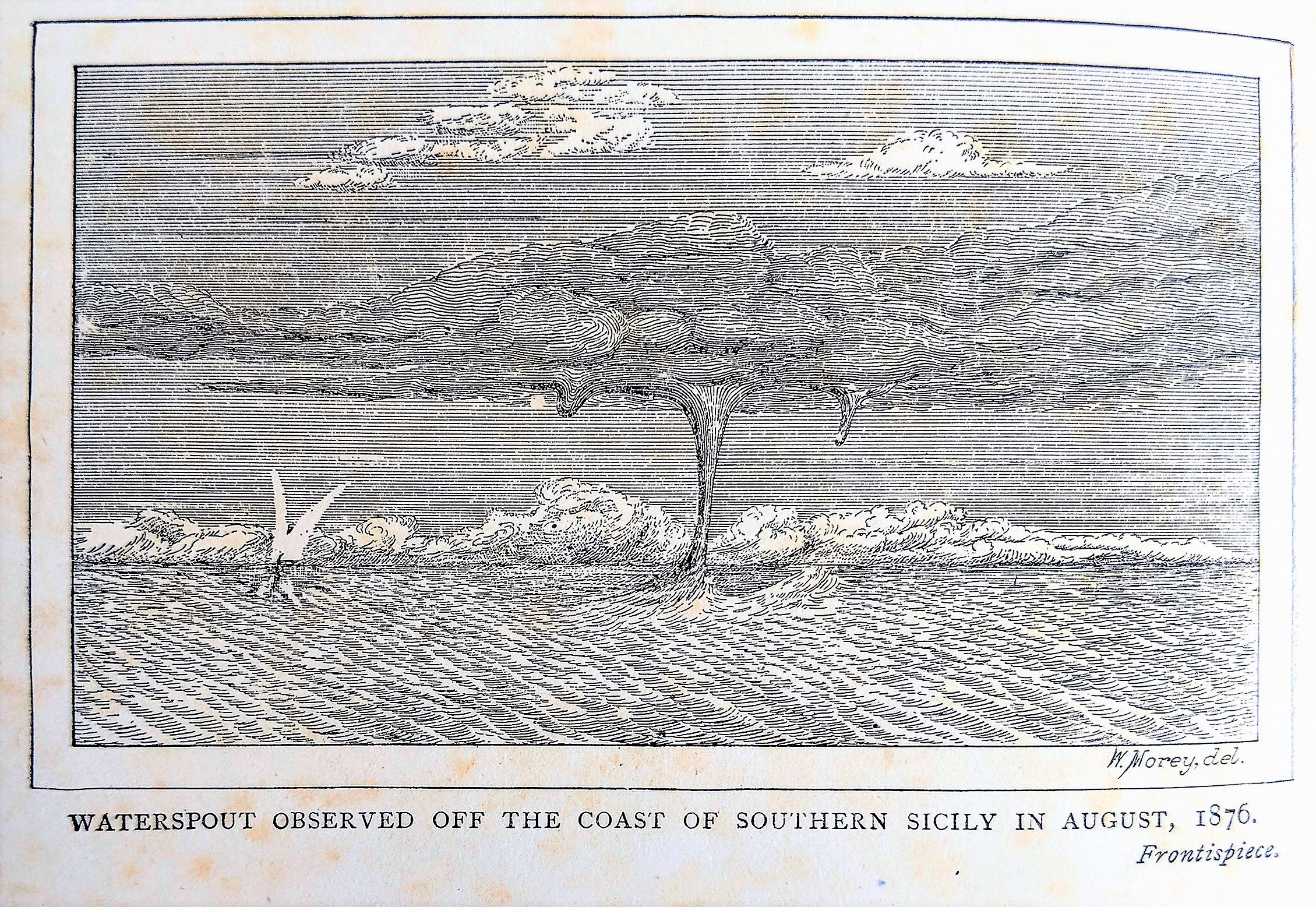
source : Rare books
William Ferrel, an American, developed a hypothesis of trade winds in 1859 after reading several observational data from various regions of the world.
Ferrel’s hypothesis quickly spread around Europe, but it received little attention.
Until his 1889 book A Popular Treatise on the Winds offered a fresh perspective on trade wind issues.
Ferrel also provided a thorough explanation of the factors that lead to tropical cyclones that form near the equator in the North Atlantic Ocean, the Arabian Sea, and the Bay of Bengal.
Ferrel concluded that tropical cyclones that form over the Indian Ocean above the equator and migrate over to the coastal regions of Bengal are more likely to affect the Bay of Bengal.
Prior to Ferrel’s explanation, Henry F. Blanford had created a table of Bay of Bengal cyclones based on the records that were accessible up until 1876.
He noticed that the trade winds from the northern and southern hemispheres congregate during October-November.
Because the two trade winds had distinct moisture contents and air temperatures, a severe low-pressure system developed that quickly intensified into a cyclone.
The Bengal Hurkaru, which is an account of the Bengal Cyclone of 1864, stated that because telegraph line construction was still ongoing at the time, Calcutta was unable to get enough warning to make adequate preparations.
Blanford came to the conclusion that the bulk of the cyclones formed in a line parallel to and immediately to the west of the Andaman and Nicobar Islands based on the data collected by the meteorological stations and observatories of Calcutta and Madras.

Prepared By: Col Rennell Map of Hindoostan, Map of India, 1788;
Source: Survey Of India
The ships’ logs of days before October 5, 1864, when the storm really slammed the Calcutta coast, provided him the information.
Atmospheric pressure and wind speed were once monitored by seagoing ships.
They saw that the southerly wind began blowing in the Bay of Bengal on October 1st, four days prior to the storm making landfall, and that it progressively shifted its path to the north.
Information on wind pressure and humidity was gathered from observatories at Kandy, Madras, Calcutta, and Agra.
They also noted that a stormy current entered the Andamans from the southwest, expanded gradually, changed its path to the southeast, and then returned to its original course on October 1 with heavy rain.
The rapid changes in air pressure and wind direction were also noted in the records of ships sailing in the Bay of Bengal.
It was also observed that the Bay of Bengal cyclone primarily happens when the monsoon is shifting.
The majority of these take place near the end of the southwest monsoon in October and November rather than at its start.
The storms that originate in the north of the Bay of Bengal often move toward the northwest, those that originate close to the Andaman islands typically go toward the northwest, and those that originate in the south of the Bay typically move toward the west.
However, this understanding of the cyclone courses would only have been helpful if it had been possible to warn India’s coastal communities.
Blanford’s observation-based model proved to be very useful during those years.
He had deduced that the barometer was lower than usual and that the cyclone was usually preceded by a strong, stormy, wet wind coming from the southwest of their site of origin.
Additionally, he advised that warnings should be sent to the interiors of Bengal if the wind was blowing from the southeast and moving to the northeast with a dropping barometer.
He also requested the establishment of setting up meteorological telegraph stations in Ceylon and Port Blair, and their connection to stations in northeastern Bengal.
Despite having access to a tremendous amount of data and a big number of weather stations and sensors giving the inputs, meteorology is still by its very nature probabilistic.
Due to data gaps, it is still not regarded as a precise science, particularly when it comes to gathering data from the huge seas, which make up 70% of the Earth.
The ability to perform real-time forecasting has been made possible by meteorologists feeding computer data every minute.
They input these data into models to comprehend how nature behaves.
However, due to the gaps, there is still some unpredictability and uncertainty, which is why meteorologists utilise probabilities when making forecasts.
Two centuries ago, the availability of data was not at this level due to technological and meteorological station restrictions.
However, meteorologists could still create models based on observations in the nineteenth century by collecting statistical data using inexpensive instruments like thermometers, anemometers, and barometers.
Links :
No comments:
Post a Comment