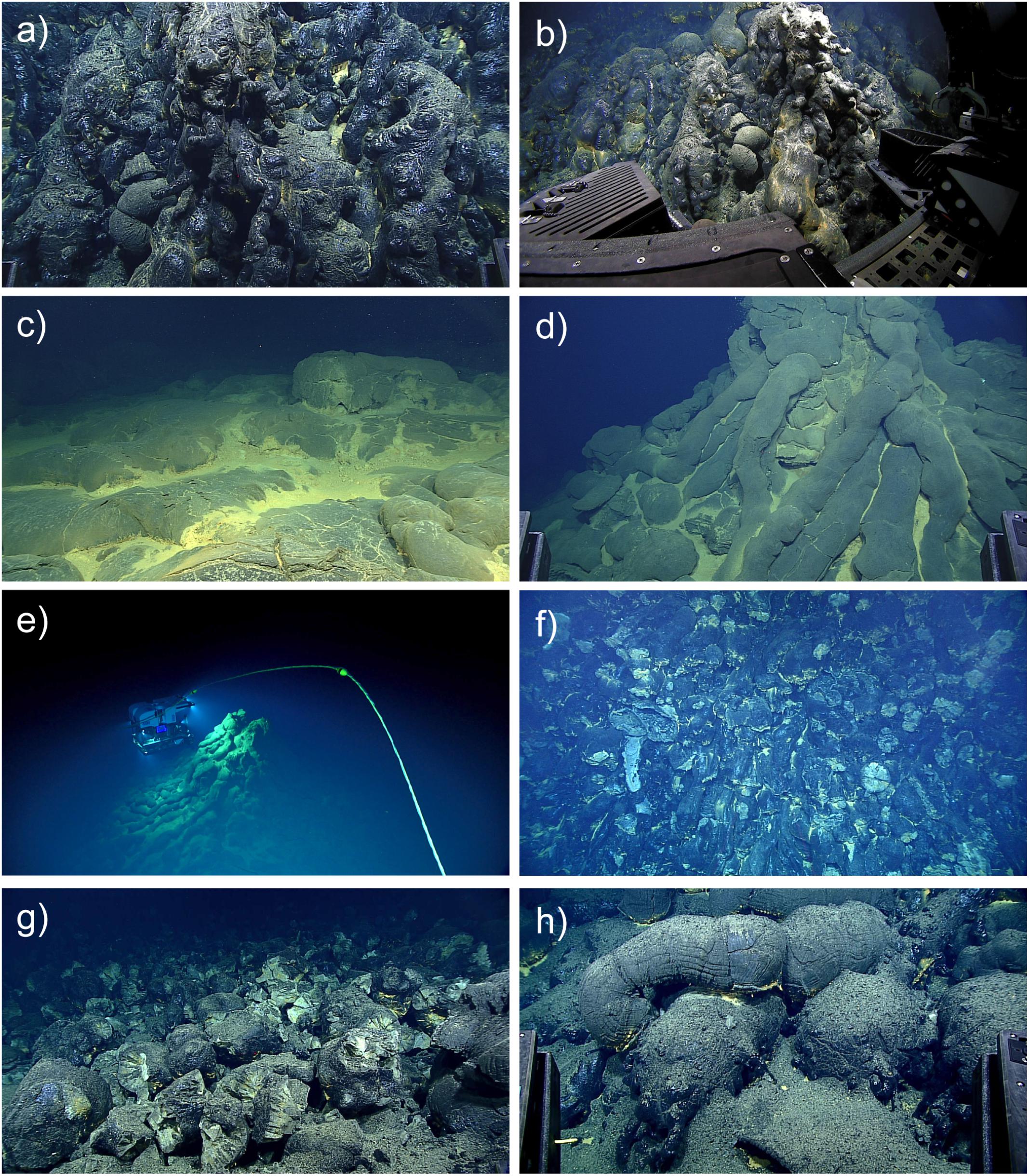
Various images made by the Deep Discoverer, a remote operated vehicle, showing lava deposits made by the eruption, including pillow tubes, glass and other formations.
Images from ROV Deep Discoverer dive EX1605L1-09 on 29–30 April 2016, which crossed the northern-most and thickest of the 2013–2015 lava flows.
Numbers in parentheses are time of photo in GMT and horizontal scale.
(a)Pillow lavas with extremely glassy finger-like buds (03:41:31, 2 m).
(b) ROV set up to sample a glassy pillow bud (03:49:32, 4 m).
(c) Broader lobes on top of one of the pillow mounds with hydrothermal sediment (00:03:48, 5 m).
(d) Conical eruptive center at the top of a mound with radiating pillow tubes and hydrothermal sediment (02:43:00, 6 m).
(e) View of ROV illuminating a conical eruptive center (02:40:20, 20 m).
(f) Nearly vertical cliff with intact and truncated pillows (01:12:11, 10 m).
(g) Primary pillow talus at base of cliff (01:06:06, 3 m).
(h)Fragmental deposit on top of pillows beyond the talus apron (01:03:14, 2 m).
Credit Chadwick WW Jr. et al
Close to the Mariana Trench and nearly three miles below sea level, scientists found evidence of an underwater eruption that was only months old.
In 2015, an international team of researchers sent robotic submersibles beneath the waves north of Guam.
They had set out to study an area south and west of the Mariana Trench — the deepest groove in Earth’s oceans — and an arc of volcanoes, hoping to spy hidden hydrothermal vents.
Localization with the GeoGarage platform (NGA chart)
Instead, they discovered a spectacular glassy labyrinth, nearly three miles below sea level.
It was recently cooled lava, the product of the deepest underwater volcanic eruption ever recorded by scientists.
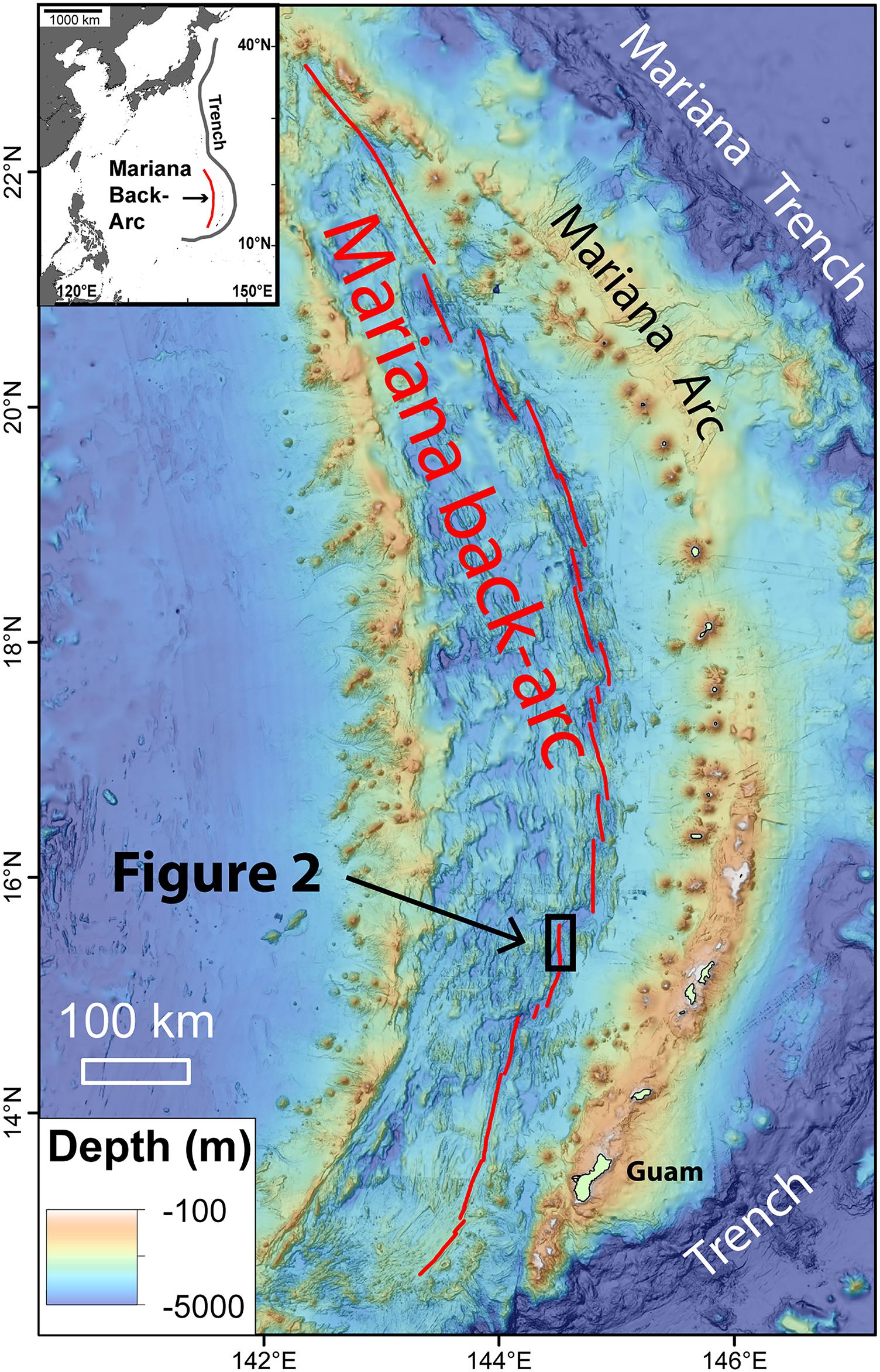
Regional map showing location of the study area on the 15.5°N segment of the Mariana back-arc. Black box shows area of Figure 2.
Inset map shows the location of the Mariana back-arc relative to the western Pacific trenches, with Japan to the north and the Philippines to the west.
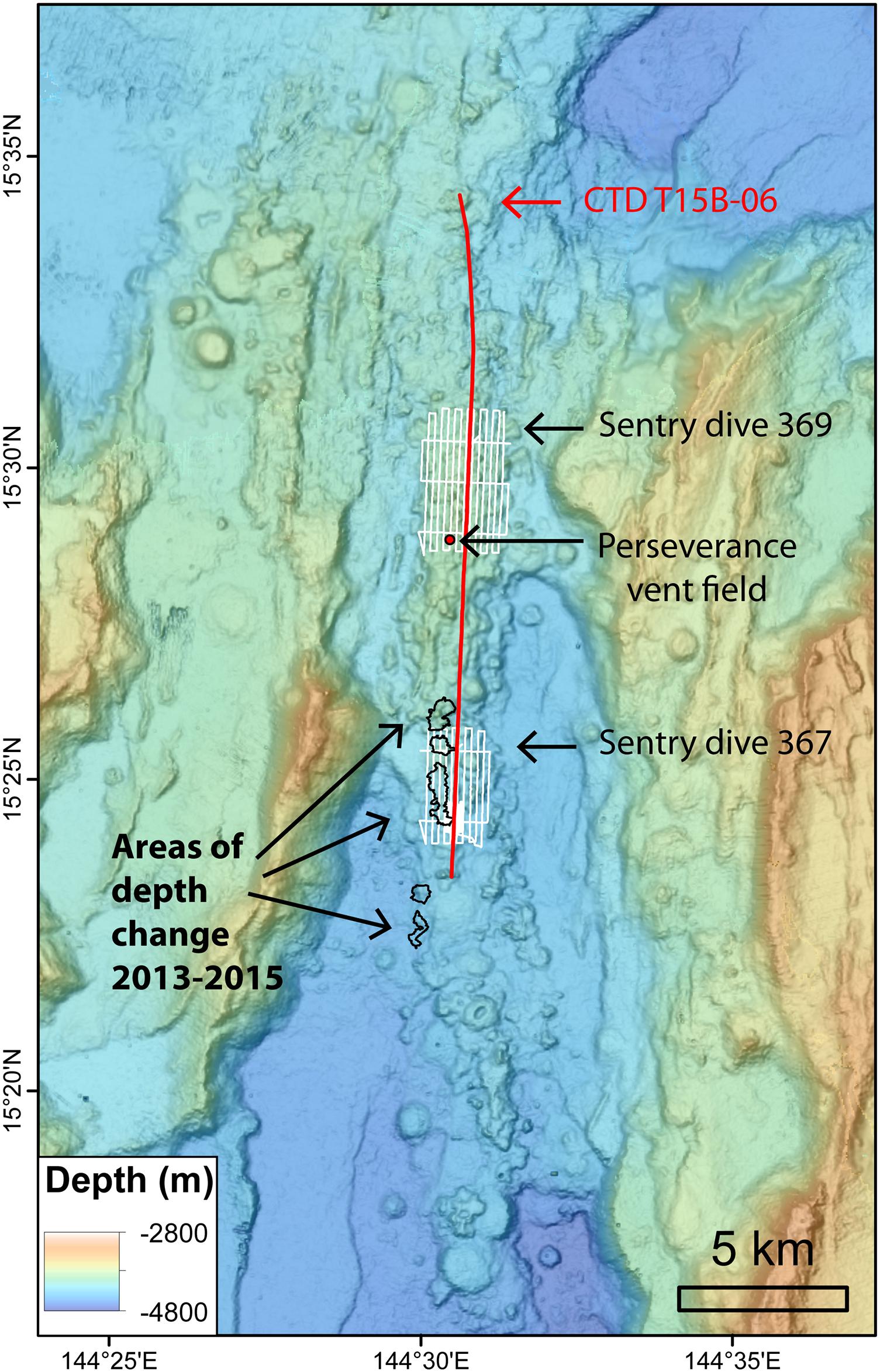
Bathymetric map of the 15.5°N segment of the Mariana back-arc showing the location of CTD tow T15B-06 (red line; data shown in Figure 3), AUV Sentry dives 369 and 367 (white lines; the latter shown in Figure 4), and areas of depth change between bathymetric surveys in 2013 and 2015 (black outlines; data shown in Figure 6). Red dot shows location of Perseverance vent field.
The identification of deep-sea eruptions happens very rarely, said Bill Chadwick, a seafloor geologist at the NOAA Pacific Marine Environmental Laboratory in Oregon and lead author of the new study, and discovering one “is an opportunity to learn about a fundamental Earth process that we know little about.”
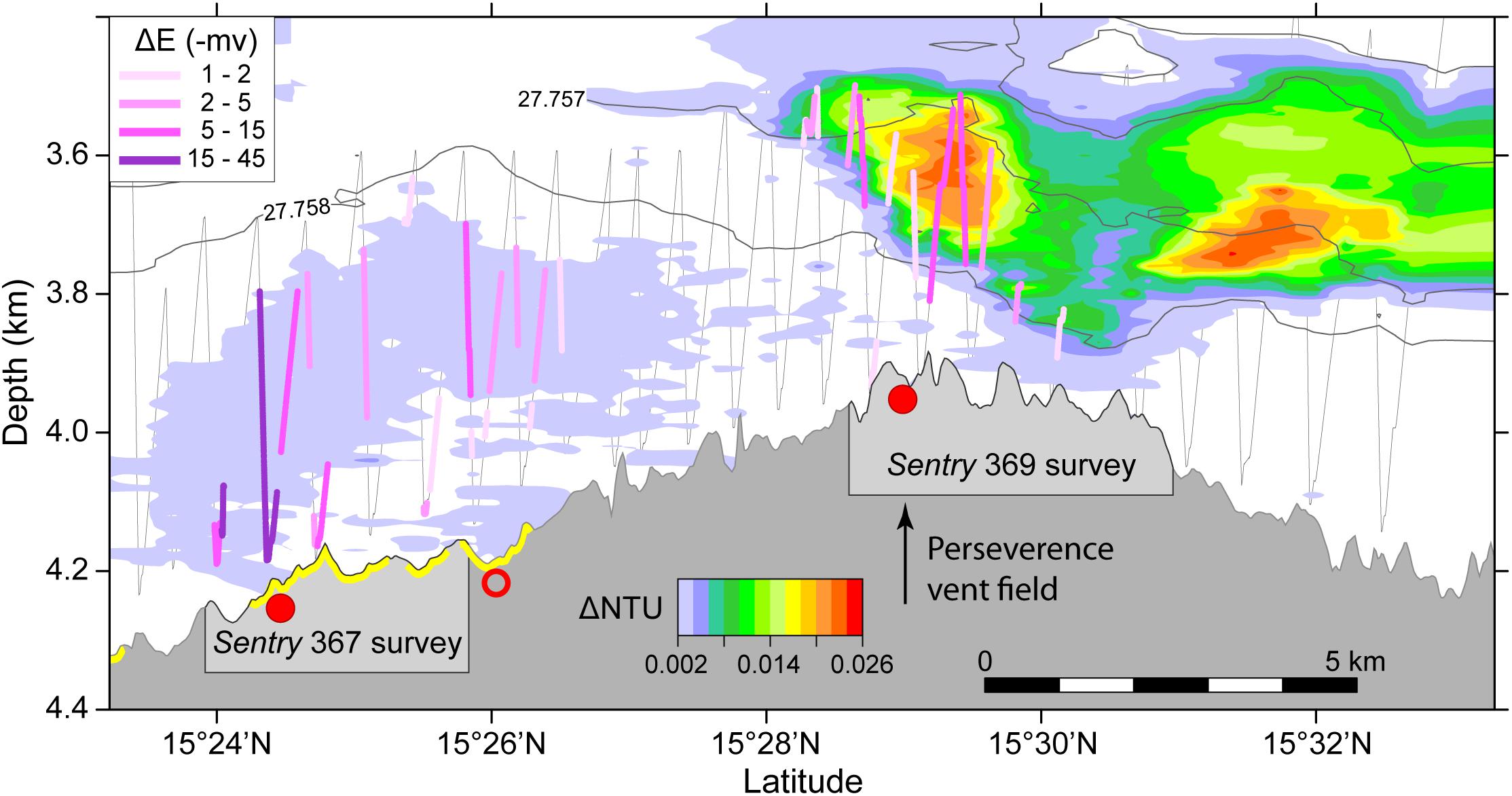
Depth cross-section along the axis of the 15.5°N segment of the Mariana back-arc showing data from CTD tow T15B-06 (from Baker et al., 2017).
Gray is seafloor profile.
Colors above seafloor show turbid particle plumes as ΔNTU anomalies.
Colored lines along CTD tow path (gray zigzag lines) show ΔE anomalies in millivolts from ORP sensor (see inset for scale).
Red dots are confirmed (solid) or inferred (open) hydrothermal sites from Baker et al. (2017).
Yellow highlight on the bathymetry profile indicates extent of new lava flows.
Note relatively high ΔE but low ΔNTU anomalies over new lava flows, and high ΔNTU and lower ΔE anomalies over northern-most hydrothermal site, at the Perseverance vent field with black-smoker chimneys.
The finding wasn’t just notable for its extraordinary depth.
The extremely young age of the lava deposit offers scientists a window into the very beginnings of what happens when a volcanic outburst occurs beneath the seas.
So often, they just see an epilogue.
“Much of what we know about underwater eruptions, their hydrothermal systems and the biological communities that grow on them is gained from studying old, even ancient, volcanic systems,” said Rebecca Williams, a volcanologist at the University of Hull in England, who wasn’t involved in the research.
Okeanos Explorer Video Bite: probing newly discovered hydrothermal vent (01/05/2016)
Commonwealth of the Northern Mariana Islands and the Marianas Trench Marine National Monument ROV Deep Discoverer takes a hydrothermal vent's temperature.
Commonwealth of the Northern Mariana Islands and the Marianas Trench Marine National Monument ROV Deep Discoverer takes a hydrothermal vent's temperature.
Around 80 percent of Earth’s eruptions take place within the oceans.
But their depth and remoteness makes finding these near-ubiquitous events difficult.
Before 1990, not a single submarine eruption had been detected.
Today, even with better instrumentation and exploration, only 40 or so have been found.
It doesn’t help that we barely know what the seafloor itself looks like.
Samuel Mitchell, a doctoral student researching underwater eruptions at the University of Hawaii at Mānoa, and who was not involved in the study, said: “We actually have better maps of the entire surfaces of the moon and Mars in comparison to our own seafloor.”
The deepest-known undersea volcano has been discovered in the western Pacific Ocean.
Credit: Oregon State University
Robotic submersibles are helping to close this information gap.
Dr. Chadwick’s team made the initial discovery using an autonomous vehicle named Sentry, which was built by the Woods Hole Oceanographic Institution.
Back in 2015, it was perusing the seafloor near where the Pacific tectonic plate is sinking beneath the Philippine Sea plate.
To the east, there’s the Mariana Trench and an arc of about 60 underwater volcanic monuments, also called seamounts.
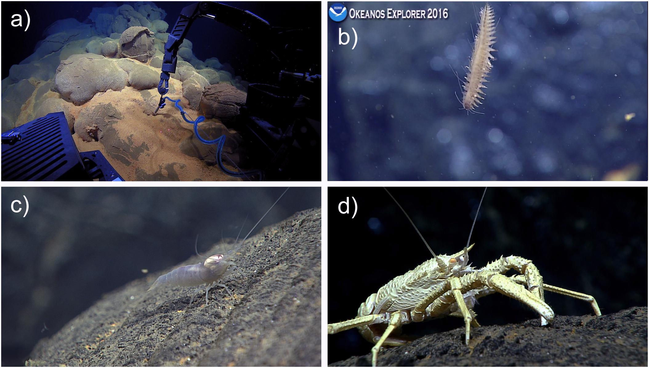
Images made by the Deep Discoverer show, clockwise from top left, a
robotic arm measuring temperature near a sea vent, a bristle worm, a
squat lobster and a shrimp.
Credit Photographs by Bill Chadwick et al
To the west of this arc, the seafloor is slowly spreading.
Here, in what is known as the Mariana back-arc, additional volcanic activity is possible — and this is where Sentry spotted the prolific lava flows.
Old lava flows were expected here, but what the researchers detected is the first known new eruption in the back-arc region.
That makes this discovery enormously serendipitous, as eruptions here are only expected every few hundred years or so.
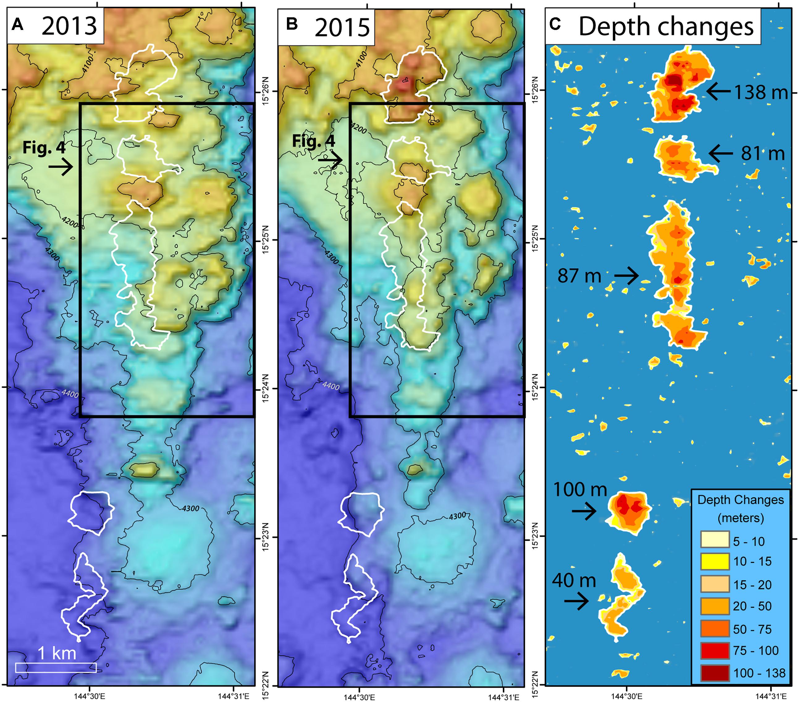
Depth changes between ship-based multibeam bathymetric surveys (numbered 1–5 from north to south in Table 1).
(A) Pre-eruption bathymetry collected in February 2013 by R/V Melville (MV1302a; EM122 sonar). (B) Post-eruption bathymetry collected in December 2015 by R/V Falkor (FK151121; EM302 sonar). (C) Depth differences between the two surveys showing 5 areas of significant depth change (outlined in white; color scale at lower right).
Numbers indicate maximum depth change within each area.
Black boxes show area of Figure 4.
After small sections of the dark, shiny lava flows were spotted by Sentry’s onboard cameras, bathymetric scans of the area from the researchers’ ship confirmed they are about 4.5 miles long and up to 450 feet thick.
Produced by the rapid quenching of lava, the individual protuberances form a surreal collection of glass.
Countless bulbous mounds and pillows protruding from the streams are adorned with narrow tubes, which the study authors compare to drips of wax on the outside of a candle.
In 2015, sediment had yet to cover the flows, and hydrothermal vents were present.
By 2016, the vents had quieted as the flow continued to cool.
Speedy, mobile creatures like shrimp and squat lobsters had moved in.
The surface was not yet hospitable for slower colonizers like sponges and anemones.
Underwater volcanic eruptions and magma flows on the sea floor have been seen for the first time ever thanks to video captured by NOAA in 2009.
James Williams talks to the lead scientist on the project to learn the story behind the explosive images.
Both the lava’s cooling rate and the incomplete invasion of life indicated the eruption likely took place only months before the team stumbled across it.
That youthfulness matters — these fresh rocks provide relatively unaltered insights into the chemical alchemy that produced them.
It is also an opportunity to watch diverse communities of living things emerge and change as the hydrothermal system first springs up and then declines.
“The closer in time we are to an event like this, I think the more we can learn about its impacts on deep-sea ecosystems and the chemistry of the oceans,” Dr. Chadwick said.
Links :
- Oregon Univ : Researchers discover deepest known underwater volcanic eruption
- ScienceAlert : We Have Found The Deepest Known Volcanic Eruption - A Field of Glass Under The Sea


No comments:
Post a Comment