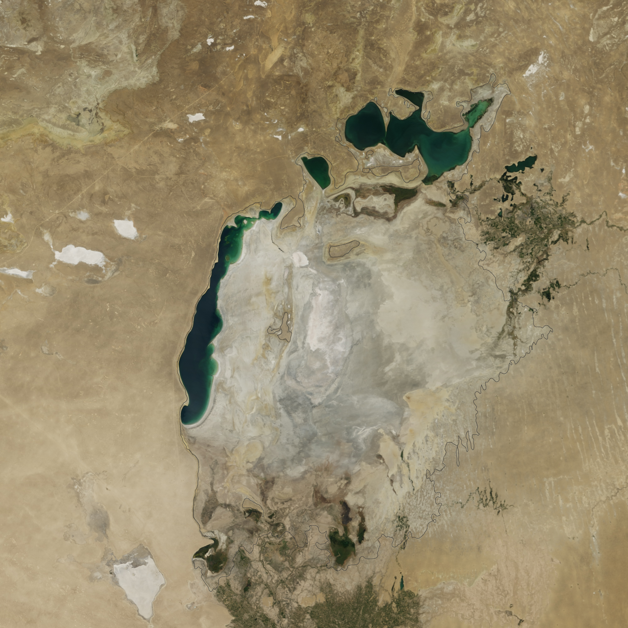
acquired August 19, 2014
Satellite images from NASA show that over the last 14 years, one of the world's largest inland bodies of water, the Aral Sea in Central Asia, has almost completely dried up and disappeared.
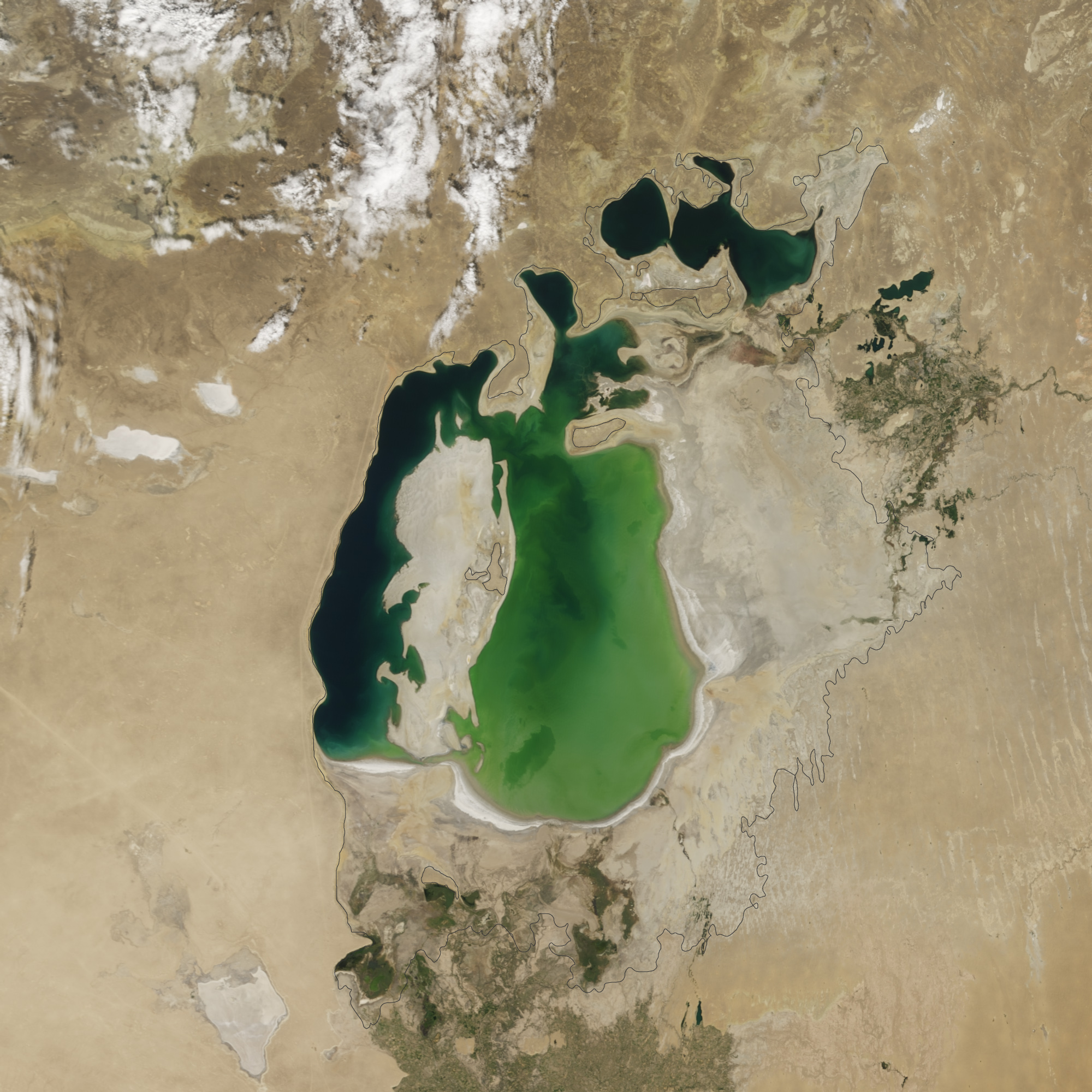
 acquired August 25, 2000

Satellite images from NASA show that over the last 14 years, one of the world's largest inland bodies of water, the Aral Sea in Central Asia, has almost completely dried up and disappeared.
NASA Earth Observatory image by Jesse Allen, using data from the Level 1 and Atmospheres Active Distribution System (LAADS).
Caption by Kathryn Hansen.
Instrument(s): Terra - MODIS
From NASA
Summer 2014 marked another milestone for the Aral Sea, the once-extensive lake
in Central Asia that has been shrinking markedly since the 1960s.
For
the first time in modern history, the eastern basin of the South Aral
Sea has completely dried.
This image pair from the Moderate Resolution Imaging
Spectroradiometer (MODIS) on NASA's Terra satellite shows the sea
without its eastern lobe on August 19, 2014 (top).
Substantial changes
are apparent when compared to an image from August 25, 2000 (bottom),
and again when compared to the approximate location of the shoreline in
1960 (black outline).
"This is the first time the eastern basin has completely dried in
modern times," said Philip Micklin, a geographer emeritus from Western
Michigan University and an Aral Sea expert.
"And it is likely the first
time it has completely dried in 600 years, since Medieval desiccation
associated with diversion of Amu Darya to the Caspian Sea."
The Aral Sea circa 1856
In the 1950s and 1960s, the government of the former Soviet Union
diverted the Amu Darya and the Syr Darya—the region's two major
rivers—to irrigate farmland.
The diversion began the lake's gradual
retreat.
By the start of the Terra series in 2000, the lake had already
separated into the North (Small) Aral Sea in Kazakhstan and the South
(Large) Aral Sea in Uzbekistan.
The South Aral had further split into
western and eastern lobes.

The changes are dramatically documented in a series of images from the Moderate Resolution Imaging Spectroradiometer (MODIS) on NASA's Terra satellite.
By 2000, when this sequence of satellite photos begins, a large portion of the sea had already been drained.
By 2000, when this sequence of satellite photos begins, a large portion of the sea had already been drained.
Instead of a single large body of water, there were now two smaller ones: the Northern and Southern Aral Seas.
The Southern Aral Sea shrunk further into two lobes connected by narrow channels at the top and bottom.
In ensuing years, the lobes get smaller and smaller.
In ensuing years, the lobes get smaller and smaller.
A drought from 2005 to 2009 accelerated the changes, NASA says.
Also in 2005, Kazakhstan completed a dam project aimed at shoring up water supplies in the Northern Aral Sea at the expense of the southern portion.
The most recent photo, from August 2014, shows just a thin sliver of water remaining on its western edge.
The eastern lobe of the South Aral nearly dried in 2009 and then saw a
huge rebound in 2010.
Water levels continued to fluctuate annually in
alternately dry and wet years.
According to Micklin, the desiccation in 2014 occurred because there
has been less rain and snow in the watershed that starts in the distant
Pamir Mountains; this has greatly reduced water flow on the Amu Darya.
In addition, huge amounts of river water continue to be withdrawn for
irrigation.
The Kok-Aral Dam
across the Berg Strait—a channel that connects the northern Aral Sea
with the southern part—played some role, but has not been a major factor
this year, he said.
"This part of the Aral Sea is showing major year-to-year variations
that are dependent on flow of Amu Darya," Micklin said.
"I would expect
this pattern to continue for some time."
Links :
- NASA Earth Observatory (2012, February 24) The Aral Sea, Before the Streams Ran Dry. Accessed September 25, 2014.
- NASA Earth Observatory (2006, April 11) Aral Sea Expansion. Accessed September 25, 2014.
- NASA Earth Observatory (2000, August 25) World of Change: Shrinking Aral Sea. Accessed September 25, 2014.
- Micklin, P. (2010, September) The past, present, and future Aral Sea.Lakes & Reservoirs: Research & Management, 15 (3), 193. Accessed September 25, 2014.
- GeoGarage blog : Stranded trawlers of the Aral Sea / Fickle Aral Sea sees some recovery
- Daily Mail : Watch one of the world's biggest seas disappear: Nasa releases series of Aral Sea satellite images showing it drying up
RT : Aral Sea: How one of world's largest lakes turned into ship cemetery
ReplyDeleteBBC : Waiting for the sea
ReplyDelete