Monday, April 12, 2021

France & misc. (SHOM) layer update in the GeoGarage platform

 203 nautical raster charts updated

The rice of the sea: how a tiny grain could change the way humanity eats


Chef Ángel León found eelgrass seeds have 50% more protein than rice – and the plant stores carbon far faster than a rainforest.
Photograph: Álvaro Fernández Prieto/Aponiente

From The Guardian by Ashifa Kassam

Ángel León made his name serving innovative seafood.
But then he discovered something in the seagrass that could transform our understanding of the sea itself – as a vast garden

Growing up in southern Spain, Ángel León paid little attention to the meadows of seagrass that fringed the turquoise waters near his home, their slender blades grazing him as he swam in the Bay of Cádiz.

It was only decades later – as he was fast becoming known as one of the country’s most innovative chefs – that he noticed something he had missed in previous encounters with Zostera marina: a clutch of tiny green grains clinging to the base of the eelgrass.

His culinary instincts, honed over years in the kitchen of his restaurant Aponiente, kicked in.
Could this marine grain be edible?

Lab tests hinted at its tremendous potential: gluten-free, high in omega-6 and -9 fatty acids, and contains 50% more protein than rice per grain, according to Aponiente’s research.
And all of it growing without freshwater or fertiliser.

The find has set the chef, whose restaurant won its third Michelin star in 2017, on a mission to recast the common eelgrass as a potential superfood, albeit one whose singular lifecycle could have far-reaching consequences. 
“In a world that is three-quarters water, it could fundamentally transform how we see oceans,” says León. 
“This could be the beginning of a new concept of understanding the sea as a garden.”

It’s a sweeping statement that would raise eyebrows from anyone else. 
But León, known across Spain as el Chef del Mar (the chef of the sea), has long pushed the boundaries of seafood, fashioning chorizos out of discarded fish parts and serving sea-grown versions of tomatoes and pears at his restaurant near the Bay of Cádiz.

 
The tiny grains within the eelgrass.
The plant is capable of capturing carbon 35 times faster than tropical rainforests.
Photograph: Álvaro Fernández Prieto/Aponiente

“When I started Aponiente 12 years ago, my goal was to open a restaurant that served everything that has no value in the sea,” he says. 
“The first years were awful because nobody understood why I was serving customers produce that nobody wanted.”

Still, he pushed forward with his “cuisine of the unknown seas”.
His efforts to bring little-known marine species to the fore were recognised in 2010 with his first Michelin star.
By the time the restaurant earned its third star, León had become a fixture on Spain’s gastronomy scene: a trailblazing chef determined to redefine how we treat the sea.

What León and his team refer to as “marine grain” expands on this, in one of his most ambitious projects to date.
After stumbling across the grain in 2017, León began looking for any mention of Zostera marina being used as food.
He finally found an article from 1973 in the journal Science on how it was an important part of the diet of the Seri, an Indigenous people living on the Gulf of California in Sonora, Mexico, and the only known case of a grain from the sea being used as a human food source.

Next came the question of whether the perennial plant could be cultivated.
In the Bay of Cádiz, the once-abundant plant had been reduced to an area of just four sq metres, echoing a decline seen around the world as seagrass meadows reel from increased human activity along coastlines and steadily rising water temperatures.

Working with a team at the University of Cádiz and researchers from the regional government, a pilot project was launched to adapt three small areas across a third of a hectare (0.75 acres) of salt marshes into what León calls a “marine garden”.

It was not until 18 months later – after the plants had produced grains – that León steeled himself for the ultimate test, said Juan Martín, Aponiente’s environmental manager.

Salt marshes near Cádiz were used to create a ‘marine garden’ where the eelgrass seeds could be sown. Photograph: Álvaro Fernández Prieto/Aponiente

“Ángel came to me, his tone very serious, and said: ‘Juan, I would like to have some grains because I have no idea how it tastes. Imagine if it doesn’t taste good,’” says Martín. 
“It’s incredible. He threw himself into it blindly, invested his own money, and he had never even tried this marine grain.”

León put the grain through a battery of recipes, grinding it to make flour for bread and pasta and steeping it in flavours to mimic Spain’s classic rice dishes.
“It’s interesting. When you eat it with the husk, similar to brown rice, it has a hint of the sea at the end,” says León. 
“But without the husk, you don’t taste the sea.”
He found that the grain absorbed flavour well, taking two minutes longer to cook than rice and softening if overcooked.

In the marine garden, León and his team were watching as the plant lived up to its reputation as an architect of ecosystems: transforming the abandoned salt marsh into a flourishing habitat teeming with life, from seahorses to scallops.

The plant’s impact could stretch much further.
Capable of capturing carbon 35 times faster than tropical rainforests and described by the WWF as an “incredible tool” in fighting the climate crisis, seagrass absorbs 10% of the ocean’s carbon annually despite covering just 0.2% of the seabed.

News of what León and his team were up to soon began making waves around the world. 
“When I first heard of it, I was going ‘Wow, this is very interesting,’” says Robert Orth, a professor at the Virginia Institute of Marine Science, who has spent more than six decades studying seagrass. 
“I don’t know of anyone that has attempted to do what this chef has done.”

We’ve opened a window. 
It's a new way to feed ourselves

According to Orth, seagrass has been used as insulation for houses, roofing material and even for packing seafood, but never cultivated as food. 
It is an initiative riddled with challenges. 
Wild seagrass meadows have been dying off at an alarming rate in recent decades, while few researchers have managed to successfully transplant and grow seagrass, he says.

In southern Spain, however, the team’s first marine garden suggests potential average harvests could be about 3.5 tonnes a hectare. 
While the yield is about a third of what one could achieve with rice, León points to the potential for low-cost and environmentally friendly cultivation. 
“If nature gifts you with 3,500kg without doing anything – no antibiotics, no fertiliser, just seawater and movement – then we have a project that suggests one can cultivate marine grain.”
 
A pilot project was successful in cultivating seagrass and obtaining grains that Ángel León then tried in different recipes. 
Photograph: www.mapdigital.es

The push is now on to scale up the project, adapting as much as five hectares of salt marshes into areas for cultivating eelgrass.
Every success is carefully tracked, in hopes of better understanding the conditions – from water temperature to salinity – that the plant needs to thrive.

While it is likely to be years before the grain becomes a staple at Aponiente, León’s voice rises with excitement as he considers the transformative possibility of Zostera marina’s minuscule, long-overlooked grain – and its reliance on only seawater for irrigation. 
“In the end, it’s like everything,” he says.
“If you respect the areas in the sea where this grain is being grown, it would ensure humans take care of it. It means humans would defend it.”

He and his team envision a global reach for their project, paving the way for people to harness the plant’s potential to boost aquatic ecosystems, feed populations and fight the climate crisis. 
“We’ve opened a window,” says León. 
“I believe it’s a new way to feed ourselves.”

Links :

Sunday, April 11, 2021

Dancing with danger

 
Surfer Kipp Caddy has spent the last 10 years chasing a dream.
Early in 2020, right before the world went a little crazy, Kipp caught what some of the local guys are calling "One of, if not the craziest wave ever made at Shipsterns Bluff."
Cinematographer Chris Bryan was in the perfect position to capture the moment at 1,000 frames per second.
A wave of a life time and the spectacular results are now being shown for the first time.

Saturday, April 10, 2021

Friday, April 9, 2021

Satellite images show huge Russian military buildup in the Arctic


From CNN by Nick Paton Walsh

Russia is amassing unprecedented military might in the Arctic and testing its newest weapons in a region freshly ice-free due to the climate emergency, in a bid to secure its northern coast and open up a key shipping route from Asia to Europe.
Weapons experts and Western officials have expressed particular concern about one Russian 'super-weapon,' the Poseidon 2M39 torpedo.
Development of the torpedo is moving fast with Russian President Vladimir Putin requesting an update on a "key stage" of the tests in February from his defense minister Sergei Shoigu, with further tests planned this year, according to multiple reports in state media.


Images show build up of Russia's military presence in the Arctic 04:15
 
This unmanned stealth torpedo is powered by a nuclear reactor and intended by Russian designers to sneak past coastal defenses -- like those of the US -- on the sea floor.

The device is intended to deliver a warhead of multiple megatons, according to Russian officials, causing radioactive waves that would render swathes of the target coastline uninhabitable for decades.

In November, Christopher A Ford, then assistant secretary of state for International Security and Non-Proliferation, said the Poseidon is designed to "inundate U.S.coastal cities with radioactive tsunamis."


An "onyx" anti-ship cruise missile launched by the Northern Fleet in Alexandra Land, near an Arctic "trefoil" base.
Credit: Russian Ministry of Defense

Experts agree that the weapon is "very real" and already coming to fruition.
The head of Norwegian intelligence, Vice Admiral Nils Andreas Stensønes, told CNN that his agency has assessed the Poseidon as "part of the new type of nuclear deterrent weapons.
And it is in a testing phase.
But it's a strategic system and it's aimed at targets ...
and has an influence far beyond the region in which they test it currently." Stensønes declined to give details on the torpedo's testing progress so far.
 
USSR polar location map, 1951

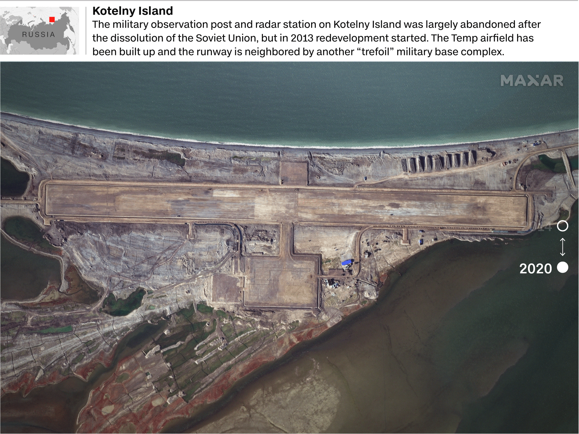
Satellite images provided to CNN by space technology company Maxar detail a stark and continuous build-up of Russian military bases and hardware on the country's Arctic coastline, together with underground storage facilities likely for the Poseidon and other new high-tech weapons.
The Russian hardware in the High North area includes bombers and MiG31BM jets, and new radar systems close to the coast of Alaska.
The Russian build-up has been matched by NATO and US troop and equipment movements.
American B-1 Lancer bombers stationed in Norway's Ørland air base have recently completed missions in the eastern Barents Sea, for example.
The US military's stealth Seawolf submarine was acknowledged by US officials in August as being in the area.
A senior State Department official told CNN: "There's clearly a military challenge from the Russians in the Arctic," including their refitting of old Cold War bases and build-up of new facilities on the Kola Peninsula near the city of Murmansk.
"That has implications for the United States and its allies, not least because it creates the capacity to project power up to the North Atlantic," the official said.
Correction: A previous version of this graphic displayed an image from 2016 instead of 2020.
This has been fixed.

Source: Satellite image ©2021 Maxar Technologies, Center for Strategic and International Studies (CSIS).
Graphic: Henrik Pettersson, CNN

The satellite images show the slow and methodical strengthening of airfields and "trefoil" bases -- with a shamrock-like design, daubed in the red, white and blue of the Russian flag -- at several locations along Russia's Arctic coast over the past five years.
The bases are inside Russian territory and part of a legitimate defense of its borders and coastline.
US officials have voiced concern, however, that the forces might be used to establish de facto control over areas of the Arctic that are further afield, and soon to be ice-free.
"Russia is refurbishing Soviet-era airfields and radar installations, constructing new ports and search-and-rescue centers, and building up its fleet of nuclear- and conventionally-powered icebreakers," Lt.
Col. Thomas Campbell, a Pentagon spokesman, told CNN.


The 50 Let Pobedy (50 years of victory) icebreaker moving through the Arctic ice, said to be in January this year, in a first transit of the eastern seas in deep winter.
Credit: Rosatom State Nuclear Energy Corporation
 
"It is also expanding its network of air and coastal defense missile systems, thus strengthening its anti-access and area-denial capabilities over key portions of the Arctic," he added.
Campbell also noted the recent creation of a Quick Reaction Alert force at two Arctic airfields -- Rogachevo and Anadyr -- and the trial of one at Nagurskoye airfield last year.
Satellite imagery from March 16 shows probable MiG31BMs at Nagurskoye for what is thought to be the first time, bringing a new capability of Russian stealth air power to the far north.
High-tech weapons are also being regularly tested in the Arctic area, according to Russian officials quoted in state media and Western officials.
Campbell added that in November, Russia claimed the successful test of the 'Tsirkon' anti-ship hypersonic cruise missile.

The Tsirkon and the Poseidon are part of a new generation of weapons pledged by Putin in 2018 as strategic game changers in a fast-changing world.
At the time US officials scorned the new weapons as technically far-fetched and improbable, yet they appear to be nearing fruition.
The Norwegian intelligence chief Stensønes told CNN the Tsirkon as a "new technology, with hypersonic speeds, which makes it hard to defend against."
On Thursday, Russian state news agency TASS cited a source in the military industrial complex as saying there had been another successful test of the Tsirkon from the Admiral Gorshkov warship, saying all four test rockets had hit their target, and that another more advanced level of tests would begin in May or June.
The climate emergency has removed many of Russia's natural defenses to its north, such as walls of sheet ice, at an unanticipated rate.
"The melt is moving faster than scientists predicted or thought possible several years ago," said the senior State Department official.
"It's going to be a dramatic transformation in the decades ahead in terms of physical access."

Source: Satellite image ©2021 Maxar Technologies, Center for Strategic and International Studies (CSIS).
Graphic: Henrik Pettersson, CNN

US officials also expressed concern at Moscow's apparent bid to influence the "Northern Sea Route" -- a shipping lane that runs from between Norway and Alaska, along Russia's northern coast, across to the North Atlantic.
The 'NSR' potentially halves the time it currently takes shipping containers to reach Europe from Asia via the Suez Canal.
Russia's Rosatom state nuclear company released elaborately produced drone video this February of the 'Christophe de Margerie' tanker completing an eastern route across the Arctic in winter for the first time, accompanied by the '50 Let Pobedy' nuclear icebreaker for its journey in three of the six Arctic seas.
Campbell said Russia sought to exploit the NSR as a "major international shipping lane," yet voiced concern at the rules Moscow was seeking to impose on vessels using the route.
"Russian laws governing NSR transits exceed Russia's authority under international law," the Pentagon spokesman said.

"They require any vessel transiting the NSR through international waters to have a Russian pilot onboard to guide the vessel.
Russia is also attempting to require foreign vessels to obtain permission before entering the NSR."
The senior State Department official added: "The Russian assertions about the Northern Sea Route is most certainly an effort to lay down some rules of the road, get some de facto acquiescence on the part of the international community, and then claim this is the way things are supposed to work."


Elizabeth Buchanan, lecturer of Strategic Studies at Deakin University, Australia, said that "basic geography affords Russia the NSR which is increasingly seeing thinner ice for more of the year making it commercially viable to use as a transport artery.
This might yet transform global shipping, and with it the movements of 90+% of all goods globally."
The State Department official believes the Russians are mostly interested in exporting hydrocarbons -- essential to the country's economy -- along the route, but also in the resources being uncovered by the fast melt.
The flexing of their military muscles in the north -- key to Moscow's nuclear defense strategy, and also mostly on Russian coastal territory -- could be a bid to impose their writ on the wider area, the official said.

"When the Russians are testing weapons, jamming GPS signals, closing off airspace or sea space for exercises, or flying bombers over the Arctic along the airspace of allies and partners, they are always trying to send a message," the official added.

Russia insists motives are peaceful and economic

Russia's foreign ministry declined to comment, yet Moscow has long maintained its goals in the Arctic are economic and peaceful.

A March 2020 document by Kremlin policymakers presented Russia's key goals in an area behind 20% of its exports and 10% of its GDP.
The strategy focuses on ensuring Russia's territorial integrity and regional peace.
It also expresses the need to guarantee high living standards and economic growth in the region, as well as developing a resource base and the NSR as "a globally competitive national transport corridor."
Putin regularly extols the importance of Russia's technological superiority in the Arctic.
In November, during the unveiling of a new icebreaker in St. Petersburg, the Russian President said: "It is well-known that we have a unique icebreaker fleet that holds a leading position in the development and study of Arctic territories.
We must reaffirm this superiority constantly, every day."
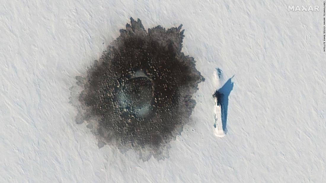
Putin said of a submarine exercise last week in which three submarines surfaced at the same time in the polar ice: "The Arctic expedition ... has no analogues in the Soviet and the modern history of Russia."
Among these new weapons is the Poseidon 2M39.
The plans for this torpedo were initially revealed in an apparently purposeful brandishing of a document discussing its capabilities by a Russian general in 2015.
It was subsequently partially dismissed by analysts as a 'paper tiger' weapon, meant to terrify with its apocalyptic destructive powers that appear to slip around current treaty requirements, but not to be successfully deployed.


A Russian Delta IV submarine photographed on top of ice near Alexandra Island on March 27, during an exercise, with a likely hole blown in the ice to its left from underwater demolition.
 
Yet a series of developments in the Arctic -- including, according to Russian media reports, the testing of up to three Russian submarines designed to carry the stealth weapon, which has been suggested to be 20 meters long -- have now led analysts to consider the project real and active.

Russia's state news agency, RIA Novosti, cited a "source" on Monday saying that tests for the Belgorod submarine, especially developed to be armed with the Poseidon torpedo, would be completed in September.
Manash Pratim Boruah, a submarine expert at Jane's Fighting Ships, said: "The reality of the weapon is clear.
You can absolutely see development around the torpedo, which is happening.
There is a very good probability that the Poseidon will be tested, and then there is a danger of it polluting a lot.
Even without a warhead, but definitely with just a nuclear reactor inside."
Boruah said some of the specifications for the torpedo leaked by the Russians were optimistic and doubted it could reach a speed of 100 knots (around 115 miles per hour) with a 100MW nuclear reactor.
He added that at such a speed, it would probably be detected quite easily as it would create a large acoustic signature.
"Even if you tone it down from the speculation, it is still quite dangerous," he said.
 
Source: Satellite image ©2021 Maxar Technologies, Center for Strategic and International Studies (CSIS).
Graphic: Henrik Pettersson, CNN
 
Boruah added that the construction of storage bays for the Poseidon, probably around Olenya Guba on the Kola Peninsula, were meant to be complete next year.
He also expressed concerns about the Tsirkon hyper-sonic missile that Russia says it has tested twice already, which at speeds of 6 to 7 Mach would "definitely cause a lot of damage without a particularly having big warhead itself."
Katarzyna Zysk, professor of international relations at the state-run Norwegian Institute for Defence Studies, said the Poseidon was "getting quite real," given the level of infrastructure development and testing of submarines to carry the torpedo.

"It is absolutely a project that will be used to scare, as a negotiation card in the future, perhaps in arms control talks," Zysk said.
"But in order to do so, it has to be credible.
This seems to be real."
Stensønes also raised the concern that testing such nuclear weapons could have serious environmental consequences.
"We are ecologically worried.
This is not only a theoretical thing: in fact, we have seen serious accidents in the last few years," he said, referring to the testing of the Burevestnik missile which was reported to have caused a fatal nuclear accident in 2019.
"The potential of a nuclear contamination is absolutely there."
 
Links :

Thursday, April 8, 2021

USS Johnston: Sub dives to deepest-known shipwreck

World’s deepest-known shipwreck finally seen.
 
From BBC by Rebecca Morelle

The USS Johnston has been relocated, surveyed and filmed at a depth of 6,456m in the Philippine Sea

A submersible has dived to the world’s deepest-known shipwreck.

The vessel reached the USS Johnston, which lies 6.5km (4 miles) beneath the waves in the Philippine Sea in the Pacific Ocean.

Explorers spent several hours surveying and filming the wreck over a series of dives.

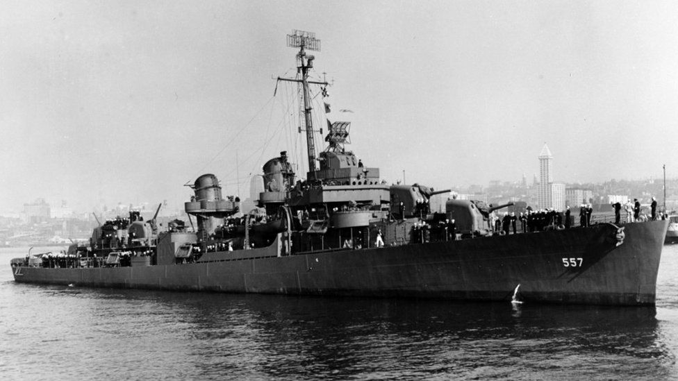
The 115m-long US Navy destroyer sank during the Battle off Samar in 1944 after a fierce battle with a large fleet of Japanese warships.

Victor Vescovo, who led the expedition and piloted the sub, said: “The wreck is so deep so there's very little oxygen down there, and while there is a little bit of contamination from marine life, it's remarkably well intact except for the damage it took from the furious fight.”

 
The destroyer was in good condition apart from the damage it sustained from the battle

The remains of the USS Johnston were first discovered in 2019, and parts of the destroyer were filmed with a remotely operated vehicle (ROV).

But a large part of the wreckage lay deeper than the ROV was able to reach, so for this expedition a submersible called the DSV Limiting Factor was deployed.

Only 141 of the USS Johnston's 327 crew survived the battle
The vessel has a 9cm-thick (3.5in) titanium pressure hull that two people can fit inside, and it is able to descend to any depth.
Previously it has explored the deepest place in the ocean, the Mariana Trench, which lies almost 11km down, as well as the Titanic.

It took several dives to relocate the wreck of the USS Johnston, but then Victor Vescovo, along with engineer Shane Eigler on one dive and naval historian Parks Stephenson on another, were able to spend time surveying and filming the destroyer.


Samar island, Philippines with the GeoGarage platform (NGA nuatical raster chart)
 
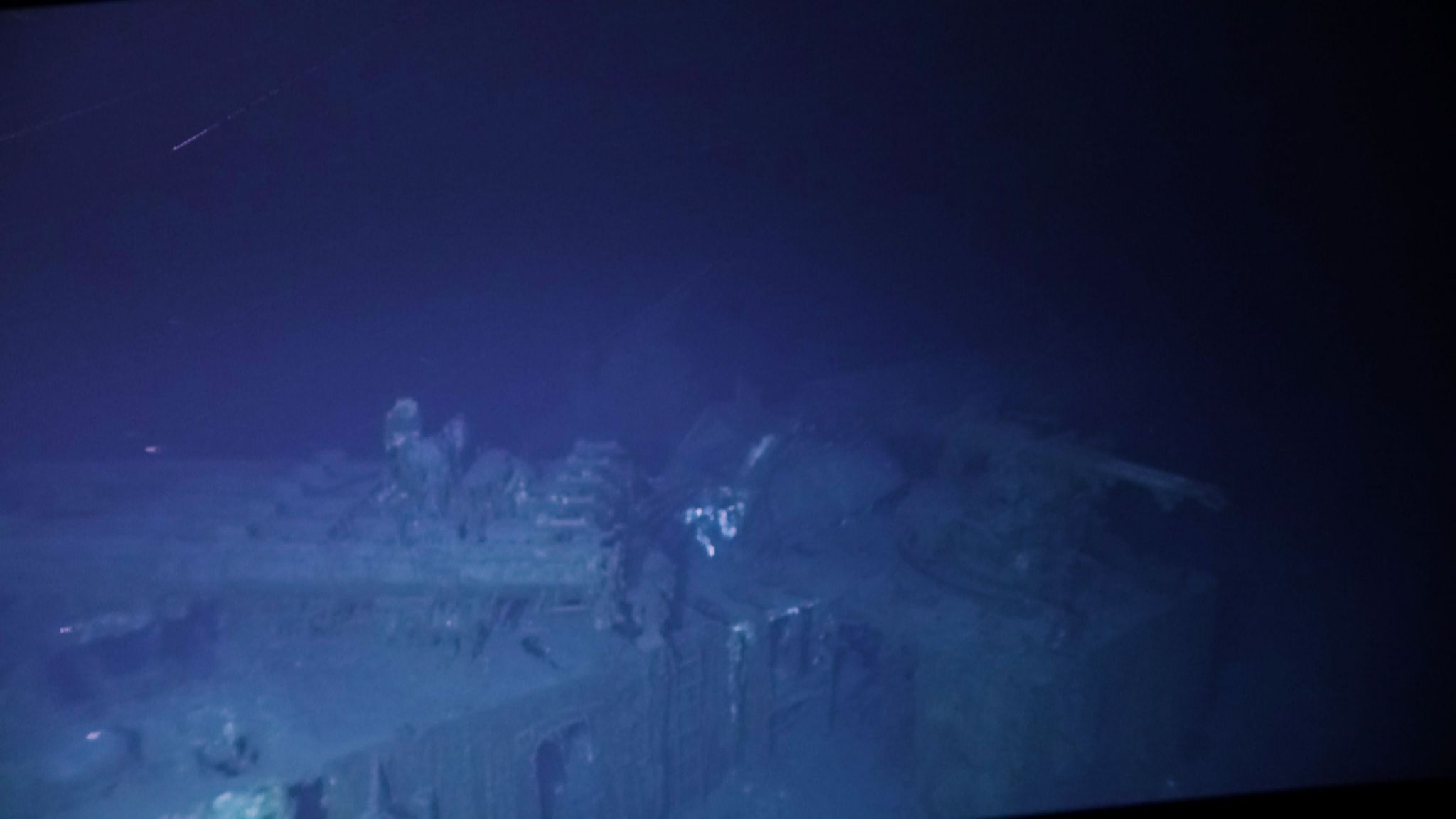
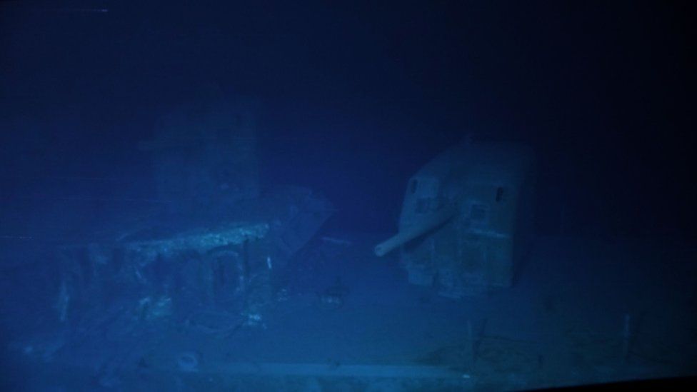
Mr Vescovo said that the hull number – 557 – was clearly visible on both sides of its bow, and two full gun turrets were also intact.
“The gun turrets are right where they're supposed to be, they're even pointing in the correct direction that we believe that they should have been, as they were continuing to fire until the ship went down,” he explained.
“And we saw the twin torpedo racks in the middle of the ship that were completely empty because they shot all the torpedoes at the Japanese.”

Image copyright Victor Vescovo /Caladan Oceanic
The team saw two forward gun mounts during the dive

The team is now working with naval historians in the hope of shedding more light on the World War Two battle.

The relatively small USS Johnston was heavily outnumbered by the Japanese fleet, which included Japan’s largest battleship, but was awarded for its courage under heavy fire
Of the crew of 327, only 141 survived the battle.
No human remains or clothing were found during the expedition, and the team laid wreaths before and after the dives.

 
Links :

With swarms of ships, Beijing tightens Its grip on South China Sea

A satellite photo of Whitsun Reef on March 23.
At one point in March, 220 Chinese ships were reported to be anchored around the reef.
Credit...Maxar Technologies

From NYTimes by Steven Lee Myers and Jason Gutierrez

After building artificial islands, China is using large fleets of ostensibly civilian boats to press other countries’ vessels out of disputed waters.


The Chinese ships settled in like unwanted guests who wouldn’t leave.

As the days passed, more appeared.
They were simply fishing boats, China said, though they did not appear to be fishing.
Dozens even lashed themselves together in neat rows, seeking shelter, it was claimed, from storms that never came.

Not long ago, China asserted its claims on the South China Sea by building and fortifying artificial islands in waters also claimed by Vietnam, the Philippines and Malaysia.
Its strategy now is to reinforce those outposts by swarming the disputed waters with vessels, effectively defying the other countries to expel them.

The goal is to accomplish by overwhelming presence what it has been unable to do through diplomacy or international law.
And to an extent, it appears to be working.

“Beijing pretty clearly thinks that if it uses enough coercion and pressure over a long enough period of time, it will squeeze the Southeast Asians out,” said Greg Poling, the director of the Asia Maritime Transparency Initiative at the Center for Strategic and International Studies in Washington, which tracks developments in the South China Sea.
“It’s insidious.”
China’s actions reflect the country’s growing confidence under its leader, Xi Jinping.
They could test the Biden administration, as well as Beijing’s neighbors in the South China Sea, who are increasingly dependent on China’s strong economy and supply of Covid-19 vaccines.

The latest incident has unfolded in recent weeks around Whitsun Reef, a boomerang-shaped feature that emerges above water only at low tide.
At one point in March, 220 Chinese ships were reported to be anchored around the reef, prompting protests from Vietnam and the Philippines, which both have claims there, and from the United States.

Chinese vessels anchored March 27 at Whitsun Reef, a boomerang-shaped feature that emerges above water only at low tide.
Credit...Philippine Coast Guard

The Philippine defense secretary, Delfin Lorenzana, called their presence “a clear provocation.” Vietnam’s foreign ministry accusedChina of violating the country’s sovereignty and demanded that the ships leave.

By this past week, some had left but many remained, according to satellite photographs taken by Maxar Technologies, a company based in Colorado.
Others moved to another reef only a few miles away, while a new swarm of 45 Chinese ships was spotted 100 miles northeast at another island controlled by the Philippines, Thitu, according to the satellite photos and Philippine officials.

“The Chinese ambassador has a lot of explaining to do,” Mr. Lorenzana said in a statement on Saturday.

The buildup has inflamed tensions in a region that, along with Taiwan, threatens to become another flash point in the intensifying confrontation between China and the United States.

Although the United States has not taken a position on disputes in the South China Sea, it has criticized China’s aggressive tactics there, including the militarization of its bases.
For years, the United States has sent Navy warships on routine patrols to challenge China’s asserted right to restrict any military activity there — three times just since President Biden took office in January.

Secretary of State Antony J. Blinken expressed support for the Philippines over the presence of the Chinese vessels.
“We will always stand by our allies and stand up for the rules-based international order,” he wrote on Twitter.

The buildup has highlighted the further erosion of the Philippines’ control of the disputed waters, which could become a problem for the country’s president, Rodrigo Duterte.

The country’s defense department dispatched two aircraft and one ship to Whitsun Reef to document the buildup but did not otherwise intervene.
It is not known whether Vietnamese forces responded.

A satellite image over Whitsun Reef on March 23.
Credit...Maxar Technologies

A satellite image over Whitsun Reef on March 28.
Credit...Maxar Technologies

Critics say China’s disregard for the Philippine claims reflects the failure of Mr.
Duterte’s efforts to cozy up to the Communist Party leadership in Beijing.

“People need to hear from the commander in chief himself, a coward to China but a bully to his own people,” said Mr. Duterte’s staunchest political opponent, Senator Leila de Lima.
Mr. Duterte has not publicly addressed the matter, though his spokesman suggested that quiet efforts to defuse the situation were underway.

China has brushed off the protests.
A spokeswoman for the foreign ministry, Hua Chunying, said that Chinese fishermen “have been fishing in the waters near the reef all along.”
Officials in the Philippines and experts said there was no evidence of that.

Whitsun Reef is part of an atoll known as Union Banks, about 175 nautical miles from Palawan, a Philippine island.
The Philippines, China and Vietnam each claim that the atoll lies within their country’s exclusive economic zones, but only China and Vietnam have established a regular physical presence there, giving each a secure, if not legal, advantage in asserting control.

Vietnam has occupied four islets in the atoll since the 1970s, while China has built two outposts on previously submerged reefs as part of its program, underway since 2014, to dredge up seven artificial islands.
Two of the outposts — Grierson Reef, occupied by Vietnam, and Hughes Reef, occupied by China — are less than three nautical miles apart.

Filipino fishermen in 2016 near Scarborough Shoal, a reef that China and the Philippines both claim.
Credit...Sergey Ponomarev for The New York Times

An international tribunal convened under the United Nations Convention on the Law of the Sea ruled in 2016 that China’s expansive claim to almost all of the South China Sea had no legal basis, though it stopped short of dividing the territory among its various claimants.
China has based its claims on a “nine-dash line” drawn on maps before the establishment of the People’s Republic of China in 1949.

A Philippine patrol first reported the large number of ships at Whitsun Reef on March 7.
According to Mr. Poling, satellite photographs have shown a regular, though smaller, Chinese presence over the past year at the reef.

By March 29, 45 ships remained at Whitsun, according to a statement on Wednesday by the National Task Force-West Philippines Sea, an agency that reports to the Philippine president’s office.
The task force counted 254 ships as well as four Chinese warships that day in the Spratlys, an archipelago of more than 100 islands, cays and other outcroppings between the Philippines and Vietnam.

The task force said the 254 ships were not fishing vessels, as Beijing claimed, but part of China’s maritime militia, an ostensibly civilian force that has become an integral instrument of China’s new maritime strategy.
Many of these boats, while unarmed, are operated by reservists or others who carry out the orders of the Coast Guard and People’s Liberation Army.

“They may be doing illicit activities at night and their lingering (swarming) presence may cause irreparable damage to the marine environment,” the task force’s statement said.

Aboard a U.S. Navy reconnaissance plane in 2018 as it observed the buildup of islands by China in the South China Sea.
Credit... Adam Dean for The New York Times

The presence of so many Chinese ships is meant to intimidate.
“By having them there, and spreading them out across these expanses of water around the reefs the others occupy, or around oil and gas fields or fishing grounds, you are steadily pushing the Filipinos and the Vietnamese out,” Mr. Poling said.

“If you’re a Filipino fisherman, you’re always getting harassed by these guys,” he said.
“They’re always maneuvering a little too close, blowing horns at you.
At some point you just give up and stop fishing there.”

Patrols and statements aside, Mr. Duterte’s government does not seem eager to confront China.
His spokesman, Harry Roque, echoed the Chinese claims that the ships were merely sheltering temporarily.

“We hope the weather clears up,” he said, “and in the spirit of friendship we are hoping that their vessels will leave the area.”

The Philippines has become increasingly dependent on Chinese trade and, as it fights the pandemic, largess.

On Monday, the first batch of Covid-19 vaccines arrived in Manila from China with great fanfare.
As many as four million doses are scheduled to arrive by May, some of them donations.
China’s ambassador, Huang Xilian, attended the vaccines’ arrival and later met with Mr. Duterte.

“China is encroaching on our maritime zone, but softening it by sending us vaccines,” said Antonio Carpio, an outspoken retired Supreme Court justice who is expert in the maritime dispute.
“It’s part of their P.R.
effort to soften the blow, but we should not fall for that.”

Links :

Wednesday, April 7, 2021

A nautical tradition fades with transition from printed to electronic charts


Robert Zaremba holds an original French nautical map of Cape Cod dating to 1757 next to a NOAA map from 1986 showing Chatham before the North Beach break at the Maps of Antiquity shop in Chatham.

From Cape Cod Times by Doug Fraser

When Michael Campbell first traveled on trans-Atlantic merchant vessels in the 1980s, they still used tools similar to those on board Columbus’ ship to find the angle of sun, moon and stars and calculate the ship’s position when it was out to sea beyond the range of the radar used for coastal navigation.

At 56, Campbell doesn’t consider himself an ancient mariner, but the cadets he takes on training cruises are more comfortable with the computer screens on the ship’s bridge than the sextant, the spanner or the chart room maps.

Freshman cadet Dylan Lydell, of Jamestown, N.Y., works on a NOAA paper chart as part of a navigation lesson on the bridge simulator at Massachusetts Maritime Academy.
NOAA is beginning the process of phasing out printed nautical charts in favor of electronic chart displays, such as the one to Lyndell's right.


“Every ship I was on prior to coming to the Massachusetts Maritime Academy used a combination of paper and electronics,” Campbell said.
“We’d put our position down on paper charts and keep them up to date.”

But he knows the next generation of cadets will likely not traverse the campus with a rolled-up chart under their arm, or plot a course at sea with a spanner and pencil lines on a chart table.

“In the future, we’ll get to where those paper charts go away,” Campbell said.

That future begins this August when the National Oceanographic and Atmospheric Administration quietly turns the page on a 170-year history of printing nautical charts.
New York Bay and harbor (Coast Survey 1845)
 
The U.S. Coast Survey, now NOAA’s Office of Coast Survey, has been researching and printing charts since 1834.
 
Lake Tahoe with the GeoGarage platform (NOAA raster chart)
NOAA will begin to implement its sunset plan for paper nautical charts this month, starting w/ the current paper chart 18665, Lake Tahoe.
 
After August, NOAA’s electronic navigational chart will be the only NOAA nautical chart of the area.
 
Lake Tahoe’s paper chart No. 18665 the first to go

When NOAA retires Lake Tahoe’s paper chart No. 18665, it will be the first in a planned phase-out of their entire library of 1,000 paper nautical charts by 2025.

“It’s going to (fade away),” said James Deal, an instructor at New England Maritime for 25 years.
The Hyannis-based school offers maritime instruction and Coast Guard captain's license courses.

It’s part of an international movement away from the charts that have been guiding mariners since 13th Century Mediterranean seafarers committed so-called "sailing instructions" and geographical renderings to stretched calfskin, with lines between ports that corresponded to wind and compass direction.

In 2016, the U.S. Coast Guard allowed commercial ships to use electronic charting systems instead of paper charts in U.S. waters.
By 2018, the International Maritime Organization required that most commercial vessels on international trips use electronic maps and navigation systems.

“Do I feel nostalgic? Absolutely, but I understand the value of technology and the safety and economy it brings,” Deal said.
 
Coast Survey made a few early chart-coloring efforts.
In this 1867 chart, increased clarity of details came at a twelve-cent cost increase

Sales of paper charts on the decline

The decision is driven by twin realities.
Merchant ships like the Ever Given, which got stuck in the Suez Canal recently, have gotten progressively bigger and require much more sophisticated and up-to-date information to navigate in areas where their margin of safety has correspondingly shrunk.

And the general boating public now relies almost exclusively on electronics.

“While most people are aware that keeping paper charts on board is a really good idea, I would guess that the vast majority of boaters don’t,” said Scott Zeien, owner of the Kingman Yacht Center in Cataumet.
The yacht center sells very few paper charts or chart books, he said.

NOAA data shows that electronic chart sales have doubled in the past decade to where over 900,000 were bought in the U.S. in 2019 and 2020, while paper chart sales were cut in half from just over 200,000 in 2010 to around 100,000 last year.

Paper charts can still be ordered through private map printing services, although NOAA will no longer update the traditional charts, only the maps printed from electronic ones.
But overall, fewer and fewer people will use them.

“Electronics have made it so easy," Zeien said.
"I keep a chart on my boat, but have I looked at it twice in the last five years? Probably not.”

But maps and the information they provide have power, said Robert Zaremba, co-owner of the Chatham store Maps of Antiquity.
They were the first things pirates grabbed when they boarded a vessel because the maps opened up harbors and trade routes to sailors who might otherwise have little local knowledge.

“If you can’t envision another part of the world without going there, you don’t have any power,” Zaremba said.

He likes the idea of maps that would correlate data he’d find useful, such as the areas where drunk drivers are most often stopped or cancer hotspots.
Modern electronic mapping does just that, with overlayed layers of information available at the push of a button.

Modern merchant vessels and cruise ships almost have too much flooding the electronic screens on their bridge, and even less need for paper maps, explained David Mackey, who chairs the Marine Transportation department at Massachusetts Maritime Academy.

They use what is known as an Electronic Chart Display and Information System (ECDIS).
Computer-driven, it melds GPS information with radar, depth finders, automated ship identification beacons, known hazards, navigational aids such as buoys and lighthouses and other navigational information onto one screen.
Coastal changes and new hazards can be updated quickly without having to wait for printing.

“ECDIS has so much data on so many pages with sub-pages and sub-menus, that mariners are required to take courses in general ECDIS training,” Mackey said.

There's so much data, the successful navigator needs to find the right mix so that the screen is useful, not cluttered.
It's no longer possible to walk onto a ship’s bridge with just paper chart navigation skills, he said.

“Every device has its time to be important,” Zaremba said.

His business is selling maps and charts, but it’s purely nostalgic.
“They are not using them on their hikes or on their boats.
People are framing them and putting them up on their walls,” he said.

But the past still has its place, experts say.
“There is value in knowing the feeling and mechanics of fixing a ship’s position,” Deal said.

Deal joined the Coast Guard at 18 and spent 30 years on active duty and in the reserves.
Satellite navigation was still in its infancy and celestial navigation and paper charts were an everyday routine.
“You can stare at a computer screen, but you have to fully interpret and comprehend what the system is telling you,” he saidl.
“A commercial airliner can fly itself, but a pilot needs to understand why the plane flies because there’s always a worst-case scenario that can occur.”


 S102 Demonstrator showing a piloting scenario near Farsund in Norway.
The demonstrator is created by Kongsberg Digital, and is based on Kongsberg Digital's Cogs library for 3D visualization.
 
That’s why the Coast Guard still requires, for now, that those seeking licenses know how to use a paper chart.
Even though the systems are supposed to have backups, computers crash and electronics fail.
When you get into trouble, you have to know where you are and how to get to where you need to be.

Mackey, who is 63, teaches electronic navigation at the maritime academy, but can appreciate the reams of yellow legal paper he went through using spherical trigonometry to calculate a fuel- and time-saving Great Circle Route across the Atlantic.

He also knows the value of having eyes on the water, noting landmarks and the seamarks.
It all feeds into a knowledge base that can help future mariners truth-test the information they are getting from computer programs.

“They are far better than I am at manipulating (the ECDIS),” he said.
But he brings what he calls the “essence of navigation.”
“How do you not just rely on what it’s spitting out,” Mackey said.

Links :

Tuesday, April 6, 2021

Mapping the world’s key maritime choke points

 
From Visual Capitalist by Carmen Ang

Maritime transport is an essential part of international trade—approximately 80% of global merchandise is shipped via sea.

Because of its importance, commercial shipping relies on strategic trade routes to move goods efficiently.

These waterways are used by thousands of vessels a year—but it’s not always smooth sailing. In fact, there are certain points along these routes that pose a risk to the whole system.

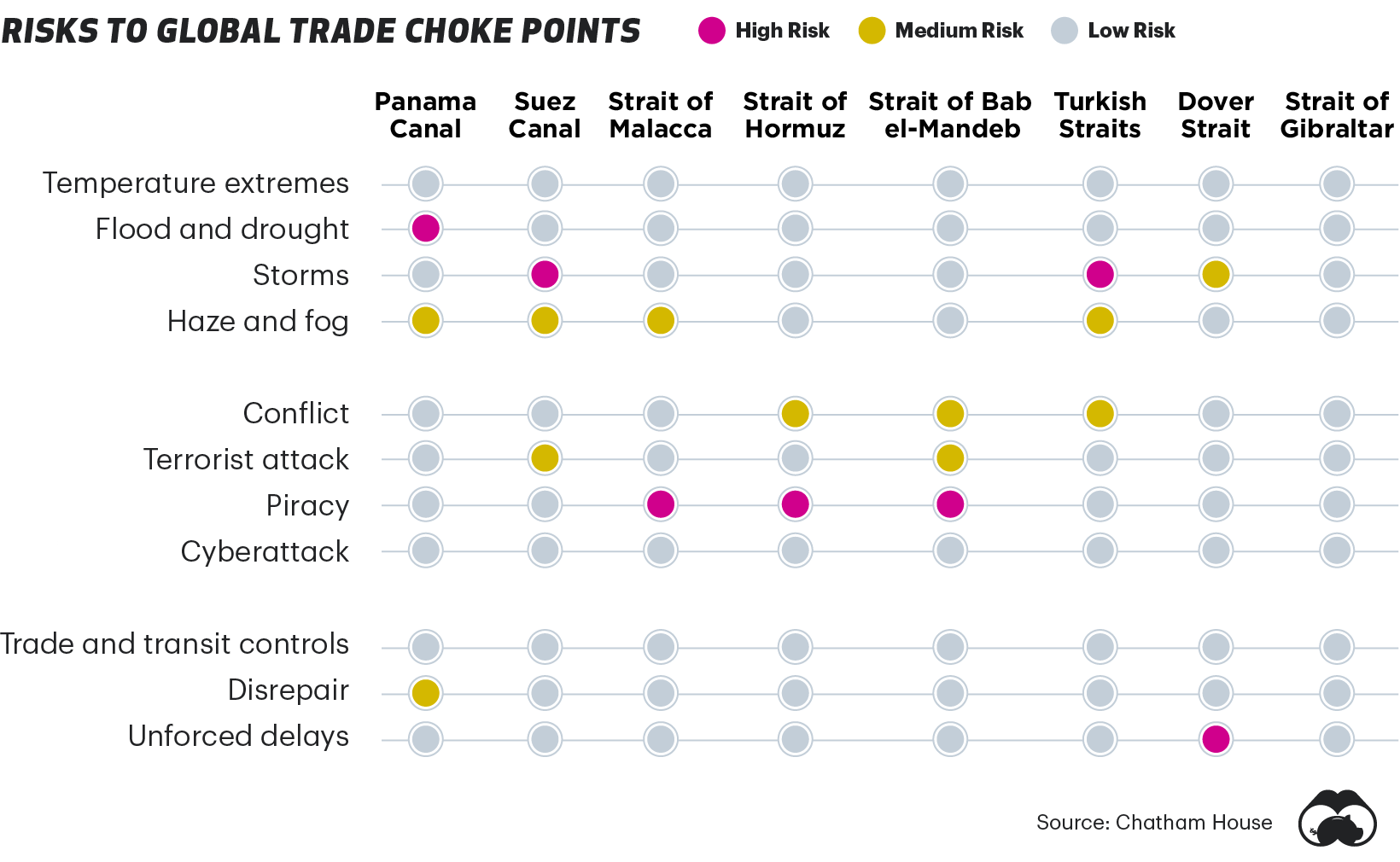
Here’s a look at the world’s most vulnerable maritime bottlenecks—also known as choke points—as identified by GIS.

What’s a Choke Point?
 
Choke points are strategic, narrow passages that connect two larger areas to one another.
When it comes to maritime trade, these are typically straits or canals that see high volumes of traffic because of their optimal location.

Despite their convenience, these vital points pose several risks:
  • Structural risks: As demonstrated in the recent Suez Canal blockage, ships can crash along the shore of a canal if the passage is too narrow, causing traffic jams that can last for days.
  • Geopolitical risks: Because of their high traffic, choke points are particularly vulnerable to blockades or deliberate disruptions during times of political unrest.
The type and degree of risk varies, depending on location.
Here’s a look at some of the biggest threats, at eight of the world’s major choke points.


Because of their high risk, alternatives for some of these key routes have been proposed in the past—for instance, in 2013 Nicaraguan Congress approved a $40 billion dollar project proposalto build a canal that was meant to rival the Panama Canal.

As of today, it has yet to materialize. 

A Closer Look: Key Maritime Choke Points
 
Despite their vulnerabilities, these choke points remain critical waterways that facilitate international trade.
Below, we dive into a few of the key areas to provide some context on just how important they are to global trade. 

The Panama Canal
 
The Panama Canal is a lock-type canal that provides a shortcut for ships traveling between the Pacific and Atlantic oceans. Ships sailing between the east and west coasts of the U.S. save over 8,000 nautical miles by using the canal—which roughly shortens their trip by 21 days.

In 2019, 252 million long tons of goods were transported through the Panama Canal, which generated over $2.6 billion in tolls.
 
The Suez Canal
 
The Suez Canal is an Egyptian waterway that connects Europe to Asia.
Without this route, ships would need to sail around Africa, which would add approximately seven days to their trips.
In 2019, nearly 19,000 vessels, and 1 billion tons of cargo, traveled through the Suez Canal.

In an effort to mitigate risk, the Egyptian government embarked on a major expansion project for the canal back in 2015.
But, given the recent blockage caused by a Taiwanese container ship, it’s clear that the waterway is still vulnerable to obstruction. 
 
The Strait of Malacca

At its smallest point, the Strait of Malacca is approximately 1.5 nautical miles, making it one of the world’s narrowest choke points.
Despite its size, it’s one of Asia’s most critical waterways, since it provides a critical connection between China, India, and Southeast Asia.
This choke point creates a risky situation for the 130,000 or so ships that visit the Port of Singapore each year.
The area is also known to have problems with piracy—in 2019, there were 30 piracy incidents, according to private information group ReCAAP ISC. 

The Strait of Hormuz
 
Controlled by Iran, the Strait of Hormuz links the Persian Gulf to the Gulf of Oman, ultimately draining into the Arabian Sea.
It’s a primary vein for the world’s oil supply, transporting approximately 21 million barrels per day.
Historically, it’s also been a site of regional conflict.
For instance, tankers and commercial ships were attacked in that area during the Iran-Iraq war in the 1980s.

The Bab el-Mandeb Strait
 
The Bab el-Mandeb Strait is another primary waterway for the world’s oil and natural gas.
Nestled between Africa and the Middle East, the critical route connects the Mediterranean Sea (via the Suez Canal) to the Indian Ocean.
Like the Strait of Malacca, it’s well known as a high-risk area for pirate attacks.
In May 2020, a UK chemical tanker was attacked off the coast of Yemen–the ninth pirate attack in the area that year.
Due to the strategic nature of the region, there is a strong military presence in nearby Djibouti, including China’s first ever foreign military base.