On the 77th anniversary of the attack on Pearl Harbor:
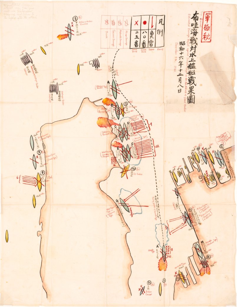
Japanese Commander Mitsuo Fuchida’s after-action damage assessment map of the 1941 attack, which was presented to Emperor Hirohito
LOC
On December 26, 1941, Japanese Vice Admiral Chuichi Nagumo, Commander Mitsuo Fuchida and Lieutenant Commander Shigekazu Shimazaki waited in the hallways of the Imperial Palace in Tokyo.
“Shortly after 1000 on December 26 Fuchida stood face-to-face with the man to whom he had dedicated his life. Later he admitted that leading the Pearl Harbor attack was much easier than telling the Emperor about it. With trembling fingers he spread out the large map of Oahu which he had prepared for the occasion…
His Majesty examined closely the pictures and damage charts with which Fuchida illustrated his briefing.
Japanese map of Pearl Harbor that was found in a captured midget sub after the attack
On December 26, 1941, Japanese Vice Admiral Chuichi Nagumo, Commander Mitsuo Fuchida and Lieutenant Commander Shigekazu Shimazaki waited in the hallways of the Imperial Palace in Tokyo.
This trio had just returned from one of the defining moments of the Imperial Navy: attacking the base of the U.S. Pacific Fleet at Pearl Harbor. Nagumo was the commander of the First Air Fleet, the force of six aircraft carriers (Akagi, Kaga, Sōryū, Hiryū, Shōkaku, and Zuikaku) that had launched the attack. Fuchida had led the first wave of aircraft from his Nakajima B5N2 Type 97 carrier attack plane (later known to Allied forces as a “Kate”) off the aircraft carrier Akagi. and signaled the famous “Tora Tora Tora”. Shimazaki had been the leader of the second wave, flying in a Nakajima B5N2 off the carrier Zuikaku.
Nagumo, Fuchida, Shimazaki and the majority of the Pearl Harbor attack force had returned to the Imperial Navy’s anchorage at Hashirajima, near Kure, on December 23 (The aircraft carriers Sōryūand Hiryū and some supporting warships had been detached to assist in the capture of Wake Island).
At Hashirajima the men were received by host of admirers and congratulators, including Admirals Isoroku Yamamoto (Commander in Chief of the Combined Fleet) and Osami Nagano (Chief of the Naval General Staff).
Amid celebrations aboard the aircraft carrier Akagi, Nagano told Nagumo, Fuchida and Shimazaki that Emperor Hirohito wanted to hear about the attack directly from them. Shimazaki and Fuchida compared their notes with the observations of other pilots and photographs from the attack to create a concise report of damage caused to U.S. installations on Oahu.
Fuchida would brief Emperor Hirohito about the attacks against naval vessels, while Shimazaki would describe attacks on airfields and other installations.
This map was drawn by Fuchida himself for the meeting and was later given to renowned Pearl Harbor researcher Gordon Prange (Fuchida also provided the English translations).
This map was drawn by Fuchida himself for the meeting and was later given to renowned Pearl Harbor researcher Gordon Prange (Fuchida also provided the English translations).
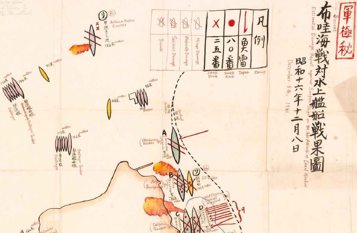
The map presents a surprisingly accurate depiction of U.S. ships present at Pearl Harbor during the attack (See [this map] (http://www.navsource.org/Naval/helpers/pearlmap.jpg) for a comparison). Most ships are also identified as belonging to a specific warship class, with also surprisingly accurate results.
Long red arrows represent suspected torpedo hits on ships, red dots represent hits from 800 kilogram bombs and small “x”s mark hits by 250 kilogram bombs.
A key to represent the assumed damage of each ship is also visible at top.
A description of the December 26 meeting appears in Gordon Prange’s phenomenal book At Dawn We Slept.
Here are some excerpts:
“Shortly after 1000 on December 26 Fuchida stood face-to-face with the man to whom he had dedicated his life. Later he admitted that leading the Pearl Harbor attack was much easier than telling the Emperor about it. With trembling fingers he spread out the large map of Oahu which he had prepared for the occasion…
His Majesty examined closely the pictures and damage charts with which Fuchida illustrated his briefing.
The Emperor asked a number of pertinent questions: On what basis were the damage estimates compiled?
How accurate did Fuchida consider them?
Were any civilian planes shot down?
Were any hospital ships in the harbor?
What was the initial reaction of the Americans?
Were any Japanese planes shot down because they could not make it back to the carriers?
Fuchida’s replies were equally crisp and to the point.
Fuchida’s replies were equally crisp and to the point.
Both Emperor and airman became so interested that time slipped by until Fuchida’s allotted fifteen minutes had more than doubled.
Shimazaki next took his turn, stammering out a brief description of the damage done to Oahu’s airfields, only too happy to take no more than his scheduled ten minutes.
…Fuchida knew he would never forget this day when he had been under the same roof with his Emperor, heard him speak, and spoken to him—the highest honor to which any Japanese could aspire. Yet a certain strain had hung over the interview.
…Fuchida knew he would never forget this day when he had been under the same roof with his Emperor, heard him speak, and spoken to him—the highest honor to which any Japanese could aspire. Yet a certain strain had hung over the interview.
His Majesty had displayed the interest of a naval man in a great naval operation, the concern on fa decent man for noncombatants, the instinct of a family man to share an experience with his wife.
But he had shown no sign of exultation.”
Japanese map of Pearl Harbor that was found in a captured midget sub after the attack
77 years ago the Empire of Japan attacked the US Pacific Fleet at Pearl Harbor.
by Brenda Lewis & Rupert Matthews
This map and aerial photo show the catastrophic damage to Battleship Row.source : National Geographic
NOAA map 19366 with the GeoGarage platform
Links :
- National Geographic : Excerpt: Rare World War II maps reveal Japan's Pearl Harbor strategy / Remember Pearl Harbor
- Britannica : Pearl Harbor attack
- Interactive Map of 1941 Pearl Harbor Attack
- Atlantic Sentinel : The Rise and Fall of Japan’s Empire in Maps
- LOC : Portion of H.O. chart #1800


LOC : Through the enemy's eyes
ReplyDelete