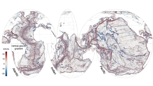
A satellite-mounted instrument has in just one year produced higher-resolution imagery of the global seafloor than that from comparable systems over the past 30 years.
The
Surface Water and Ocean Topography (SWOT) satellite-mounted instrument
package is revolutionizing several areas of oceanography.
Scripps
Institution of Oceanography at UC San Diego researchers Yao Yu and David
Sandwell with colleague Gerald Dibarboure reveal sharper images of the
seafloor made from only one year's worth of data collected from SWOT
flyovers.
For the other 75%, the only information comes, indirectly, from satellite altimeters that measure the detailed shape of the sea surface.
This shape provides information about the variations in gravity from undersea topography, so altimeter data provide most of the seafloor topography shown in common map programs such as Google Earth.

The parallel ridges of abyssal hills, as seen by the Surface Water and Ocean Topography satellite, extend out from the flanks of a seafloor spreading center (black lines) in the Indian Ocean.
-Yao Yu-
Satellite communication devices
Yao Yu, a postdoctoral researcher at Scripps Institution of Oceanography at UC San Diego, and colleagues revealed the results produced by the Surface Water and Ocean Topography (SWOT) radar altimeter in a study published Dec 13 in the journal Science.
The team used SWOT data to transform what may have resembled blurry blobs into discernible seamounts, ridges and troughs.
They compared SWOT data to 30 years' worth of data from traditional altimetry that only measured in one dimension rather than in the swaths that SWOT measures.
"In this gravity map made from merely one year of SWOT data, we can see individual abyssal hills, along with thousands of small uncharted seamounts and previously hidden tectonic structures buried underneath sediments and ice," said Yu.
"This map will help us to answer some fundamental questions in tectonics and deep ocean mixing."
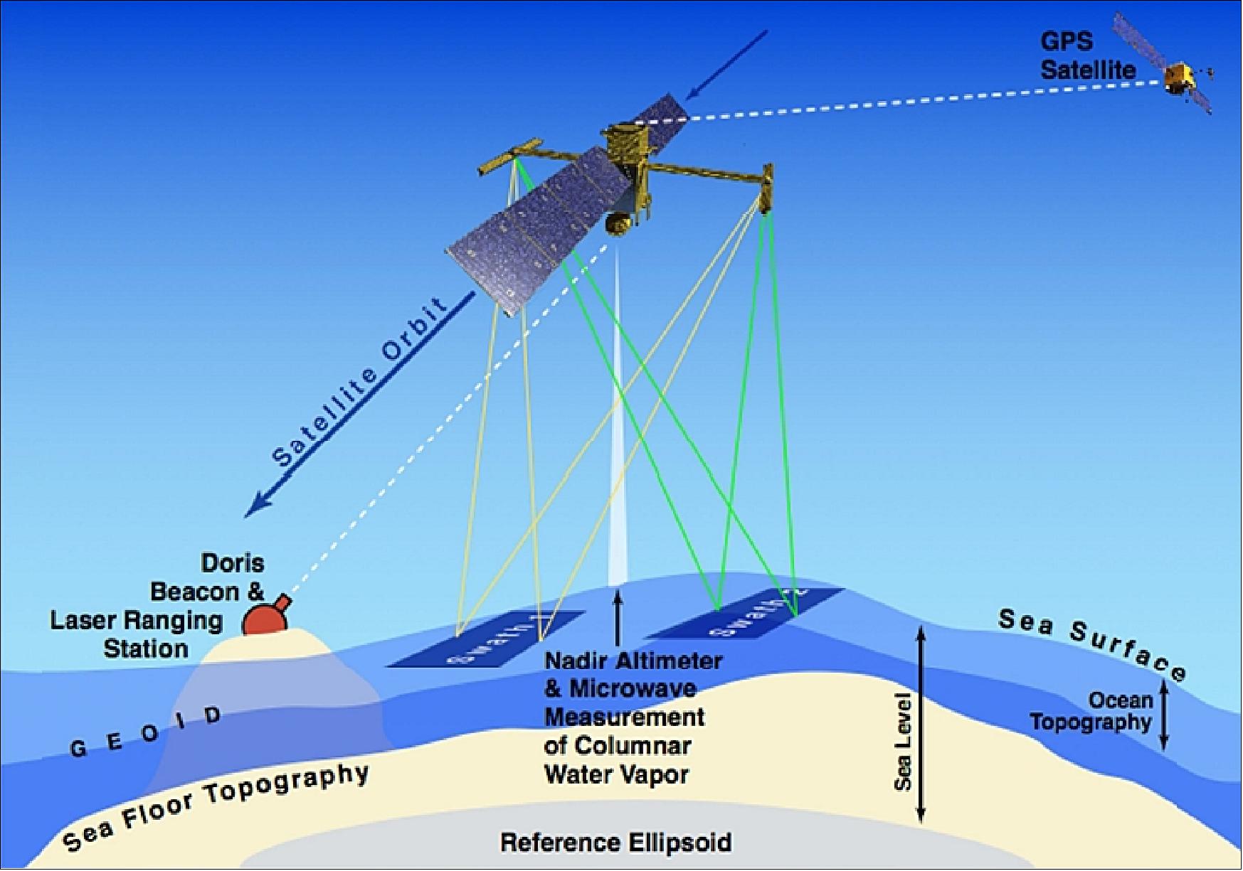
A multipurpose instrument package, SWOT can also resolve subtle nuances of ocean circulation by measuring the topography of the ocean surface, which is ever-changing.
Those data show what gravity's pull is like across given swaths of ocean, revealing phenomena such as internal waves the way a medical imaging device can view internal organs of the body.

The SWOT measurement concept (image credit: NASA)
The instrument-packed satellite, launched on Dec. 16, 2022, is a joint endeavor by NASA's Jet Propulsion Laboratory ( JPL) and its French counterpart CNES (Centre National D'Etudes Spatiales), with contributions by the Canadian and UK Space Agencies.
Scripps Oceanography joined six other research institutions leading ocean campaigns based on SWOT data.
Scripps Oceanography joined six other research institutions leading ocean campaigns based on SWOT data.
Co-authors of the study include geophysicist David Sandwell from Scripps Oceanography and Gerald Dibarboure from the Centre National d'Etudes Spatiales in Toulouse, France.
The ultimate resolution of marine gravity from SWOT will provide sharpness to the level of at least eight kilometers (five miles).
That is still not as detailed as the 200-meter (650-foot) scale resolution obtained from ship-mounted instruments but will cover the three-quarters of the seafloor not mapped by ships.
"We haven't reached the plateau yet," said Yu.
"With more data accumulated we will be able to study changes in the marine gravity field, such as from undersea volcano eruptions."
Sandwell, already the originator of most Google Earth seafloor imagery, is now leading a global effort with the Technical University of Denmark and the U.S. National Geospatial Intelligence Agency, the Naval Research Laboratory, NOAA, and the French agency Collecte Localisation Satellites to make an improved global seafloor map using SWOT marine gravity combined with all publicly available ship soundings.
Links :
- Research Report:Abyssal marine tectonics from the SWOT mission
- Science : Thousands of previously unknown mountains and hills spotted in best-yet seafloor map
- LiveScience : Satellites reveal stunningly detailed maps of Earth's seafloors
- Scripps : Swot sharpens seafloor focus
- Oceanographic : Nasa unveils hidden volcanoes in 'unprecedented' view of seafloor
- ePortal : SWOT (Surface Water Ocean Topography)

No comments:
Post a Comment