Thursday, May 31, 2018

Amid ice melt, new shipping lanes are drawn up off Alaska

courtesy of Audubon Alaska

From Scientific American by Margaret Krie Hobson

Special protections have also been granted for wildlife and coastal communities potentially threatened by oil spills

Early this month, the Colorado-based National Snow and Ice Data Center reported that winter sea ice levels in the Bering Sea had dropped to a record low level for this time of year.

That wasn’t surprising news to the Alaska Native villages along the state’s western coast. For the last decade, those communities have been enduring the impacts of a warming climate, from the melting tundra that’s causing waterfront homes to fall into the ocean to a lack of coastal sea ice, which traditionally protected those communities from winter storm surges.

Now the increasingly open waters are attracting new ship traffic to the Bering Strait, Bering Sea and Chukchi Sea, noted Austin Ahmasuk, a marine advocate for Kawerak, an Alaska Native regional tribal consortium.
“If you look at the ship tracts in the Bering Sea over the last 10 years, it’s been like a big bowl of spaghetti, with ships going all over the place,” said Ahmasuk, who lives in Nome, Alaska.
“The shipping industry is increasing, and all of the other things that are potential harmful threats from shipping are increasing,” he said.

 Bering Strait with the GeoGarage platform (NOAA chart)

Last week, the International Maritime Organization, the United Nations’ global regulatory body for international shipping, took steps to bring some order to the growing ship traffic streaming through the Bering Strait.

At a London meeting, the IMO’s senior technical body, the Maritime Safety Committee, accepted a proposal to create six two-way sea routes for ships traveling between the Arctic and Pacific oceans.
The plan, developed jointly by Russia and the United States, is intended to be voluntary and to only apply to all domestic and international vessels weighing 400 tons or more.

The IMO safety committee also identified six precautionary areas located along Russia’s Chukotskiy Peninsula and Alaska’s Seward Peninsula to help ships avoid shoals, reefs and islands that lie close to the two-way routes.

At the same time, the IMO provided special protections for the communities living on three Bering Strait islands that are in harm’s way from vessels in the Bering Strait.

The group accepted a proposal from the U.S. Coast Guard to designate new environmentally important “areas to be avoided” by ships traveling near Alaska’s St. Lawrence Island, Nunivak Island and King Island in the Bering Strait.

 The steep, rocky cliffs on the eastern shore of Little Diomede off Alaska’s Arctic coast provide habitat for seabirds that feed in Bering Strait waters.

 Diomede islands and the Russia-US frontier with the GeoGarage platform (NOAA chart)

Russia and the United States are also in talks to set up new protections around the Diomede Islands in the Bering Strait.
Those two islands are located 2 ½ miles apart, with the western Big Diomede governed by Russia and eastern Little Diomede part of Alaska.

Also at the IMO meeting, the safety committee announced plans to assess the safety, security and environmental soundness of autonomously operated ships (Greenwire, May 25).

That study will examine whether vessels operated with limited or no human help can comply with a variety of international conventions, including mandates that require all vessels to have procedures for recovering people from the water and to help tow disabled ships.

The shores between the Arctic and Pacific oceans are home to dozens of small Alaskan and Russian indigenous villages that maintain a traditional subsistence way of life.
The area also hosts one of the world’s major marine migrations of bowhead and beluga whales, Pacific walruses, and ice seals, as well as vast populations of seabirds.

Now, the increasingly open Arctic waters are beginning to attract new cargo ships, tourism, oil and gas exploration, and research and scientific activities.
The growing marine traffic is problematic in regions that are relatively shallow, particularly for ships that continue to rely on 100-year-old nautical charts, according to the IMO.

 Image Courtesy: Champion Tankers

The potential impact of increased shipping on Alaska Native communities became clear two years ago when the 599-foot Norwegian tanker Champion Ebony ran aground offshore from Nunivak Island in the Bering Sea while carrying 14.2 million gallons of fuel products.

None of the fuel leaked from the ship. But the close call raised local concerns that an oil spill could have devastated local resources, Albert Williams, president of the Native village of Mekoryuk on Nunivak, said in a letter to the Obama administration.
“At the same time, our community, which would have been on the front line of an oil spill response, has virtually no infrastructure or capacity to address a risk of that scale,” Williams wrote.

The IMO’s adoption of new shipping routes and environmental protections was praised by U.S. conservation groups that have been working with coastal communities in Alaska and Russia.

Kevin Harun, Arctic program director for Pacific Environment, praised the IMO for beginning to bring order before ship traffic gets out of hand.
“Finally, decisionmakers are getting ahead of the curve to protect the environment and subsistence in advance of this increase in traffic,” he said.

Eleanor Huffines, senior officer with the Pew Charitable Trusts’ U.S. Arctic program, described the IMO action as “a significant step toward safer shipping in the Arctic.”
“These measures will keep vessels on the safest course and reduce the risk of them running aground, colliding or interfering directly with subsistence hunting,” Huffines said.

Coast Guard officials said the new shipping routes, developed in conjunction with the Russian government, will go a long way toward reducing the potential for marine casualties and environmental disasters.
“This is a big step forward as the U.S. Coast Guard continues to work together with international, interagency and maritime stakeholders to make our waterways safer, more efficient and more resilient,” said Mike Sollosi, chief of the Coast Guard’s Navigation Standards Division.

The proposal to create shipping lanes grew out of the Coast Guard’s Port Access Route Study of the Bering Strait, which was completed last year.
Sollosi said the study was the product of a decade of collaboration with international, interagency, industry and private stakeholders and extensive coordination with community residents along the coasts of Alaska.

Links :

Wednesday, May 30, 2018

El Faro and mental models


NTSB contracted for a dynamic motion analysis of El Faro, which also used the post-storm weather analysis model for wind and sea inputs.
This video shows the results of simulations with El Faro underway at about 17 knots, at 3:30 on the morning of the sinking.
The ship has a 4-degree list... similar to the windheel calculated from the beam wind at the time.
Please note that the vessel motions match the models' output data, but waves are not accurately reflected.

From WorkBoat by Joel Milton 

The National Transportation Safety Board, NTSB, has released their final report on the sinking of the El Faro cargo ship.
In its final report into the disaster, the NTSB said the Captain’s decisions and TOTE’s poor oversight and inadequate safety management system led to the sinking, the deadliest shipping disaster involving a U.S.-flagged vessel in more than 30 years.
The summary includes detailed pictures and even an artist rendering of what the ship may look like sitting 3 miles below sea level on the ocean floor.
All 33 crew members perished in the accident on October 1, 2015.
The 790-foot ship went down 430 miles southeast of Miami during Hurricane Joaquin, a category 3 storm.

It’s not a pretty picture, no matter what angle you view it from.
The findings from the U.S. Coast Guard and the National Transportation Safety Board after concluding their separate investigations of the now infamous sinking of the 790′ El Faroin the Bahamas on Oct. 1, 2015, are sobering stuff.

In spite of the fact that various parties representing various interests will continue to dispute portions of the Coast Guard and NTSB reports, the many failures and shortcomings that led to the disaster leave no one untouched.

Sinking of US Cargo Vessel SS El Far near Acklins and Crooked Island Bahamas October1, 2015 This two-dimensional animation reconstructs the sequence of events leading to the sinking of the US-flagged cargo vessel SS El Faro in the Atlantic Ocean near Acklins and Crooked Island, Bahamas, which occurred on the morning of October 1, 2015.
The animation displays the position of El Faro as a yellow circle, and a solid white line indicates the track path of the vessel.
During the animation, the planned course and proposed course changes for El Faro are shown as dotted white lines.
The Voyage Data Recorder (VDR) was recovered on August 8, 2016. The VDR retained the last 26 hours of conversation on the bridge and vessel operating data.
Data from the VDR were used to determine the position and heading of the accident vessel.
The bridge audio from the VDR was also used in reconstructing the sequence of events in the accident.
The animation does not depict visibility conditions at the time of the accident.
The animation includes audio narration, and the script of the narration is appended to this description/disclaimer.
The animation begins with an overall map of the area between Jacksonville, Florida and San Juan, Puerto Rico.
An inset photograph of the fully loaded El Faro is shown in the upper right side of the screen, and the typical course from Jacksonville to San Juan traveling to the east of the Bahama Islands is depicted.
 An inset photograph shows the VDR in its position on El Faro before the voyage; the inset transitions to a photograph of the VDR in its location on the bottom of the ocean before it was recovered.
An arrow indicating north, and a scale are shown in the lower left side of the screen.
The departure of the El Faro on September 29, 2015 at 9:48 pm Easter Daylight Time (EDT) is indicated, along with the position and development of Hurricane Joaquin from a tropical depression through a tropical storm to a hurricane.
A series of predicted storm tracks are animated, indicating that the storm was consistently predicted to move southwest, then turn north.
The National Hurricane Center’s Best Track (the actual track calculated after the accident) is also shown.
The date and time in EDT of selected events are displayed on the lower left side of the screen, as they are depicted or when mentioned in the narration.
The sequence of events starts at 5:36 am EDT on September 30 with the earliest information available from the VDR.
The position of El Faro is shown along with the predicted storm tracks from Bon Voyage System (BVS) and from the National Hurricane Center Sat-C, plus the National Hurricane Center Best Track.
The hurricane position is interpolated on the BVS or Sat-C tracks to indicate where the hurricane would have been expected to be at any time.
The BVS information is shown in blue, the Sat-C information is shown in red and the National Hurricane Center Best Track is shown in black.
Beginning at 2:30 pm EDT on September 30, the animation changes to a closer view including the islands in the Bahamas, with the islands of San Salvador, Rum Cay and Samana Cay identified with text labels.
The Old Bahama Channel north of Cuba is also labeled with text. Beginning at 12:00 am EDT on October 1, the animation changes to a closer view centered on San Salvador, Rum Cay and Samana Cay, which are identified with text labels.
The Old Bahama Channel north of Cuba is again labeled with text.
An inset photograph looking at the aft and starboard side of El Faro is shown, superimposed with twelve white ovals to indicate the openings in the hull that would have allowed water to enter the second deck of the vessel.
Beginning at 5:43 am EDT on October 1, the animation changes to closer view showing the position, heading and track path of El Faro, along with Samana Cay identified with a text label.
The vessel is shown 30 times actual size.
Selected summarized or paraphrased comments from the bridge audio from the VDR are displayed as text along with the time in EDT at the time they occurred.
The center of the hurricane along the National Hurricane Center Best Track is shown, along with the wind circulation directions.
An inset photograph illustrates a scuttle from El Faro.
An inset graphic indicates the listing of the ship to starboard or to port, as reported in the narration. The animation is followed by an underwater photo of the stern of El Faro resting on the seafloor. 

Poor situational awareness, aided and abetted by inadequate professional training, an ineffective safety culture afloat and ashore, and an unwillingness to consider worst-case scenarios and possible alternatives to avoid them, led directly to a series of clearly bad operational decisions.
But these decisions did not occur in a vacuum.
A complete lack of checks and balances, both on the water and ashore, resulted in the voyage gradually snowballing into a mass-fatality disaster.
Insufficient safety support and oversight from every level — corporate, regulatory, etc. — laid the foundation for it all to unravel, resulting in the deaths of 33 crewmembers for no good reason at all.

courtesy of Maritime Executive
“We may never understand why the captain failed to heed his crew’s concerns about sailing into the path of a hurricane, or why he refused to chart a safer course away from such dangerous weather,” said NTSB Chairman Robert L. Sumwalt.
“But we know all too well the devastating consequences of those decisions.”

There is much to think about, but I’ll point first to remarks made by NTSB Chairman Robert Sumwalt at one of the hearings in Washington, D.C. Referring to the El Faro’s captain, Michael Davidson, he said, he “had a mental model that the hurricane would be in one place, and based on that mental model and based on his previous experience he thought they were going to be OK.”

That mental model proved to be wrong, and with fatal consequences.
Since we all build mental models for everything we do (even if you’re unaware of it) and no one is immune from building a bad one, you might want to consider the serious ramifications of that fact.

As for the value of experience, consider this: Davidson’s previous experience did not help him and probably pushed him further into a corner from which there was no escape.

Links :

Tuesday, May 29, 2018

How to save the high seas


From Nature by Olive Heffernan

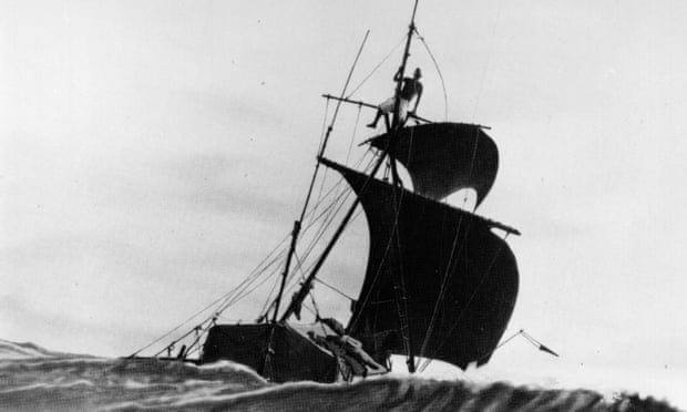
In the early fifteenth century, Portuguese sailors reached a becalmed part of the Atlantic Ocean, coated with mats of gold-brown seaweed.
Under windless skies, their ships drifted idly with the currents.
The sailors named the seaweed Sargassum — after its resemblance to a Portuguese plant — and the region eventually became known as the Sargasso Sea.

Initially thought to be an oceanic desert, this part of the Atlantic is now recognized as a watery rainforest.
It is one of Earth’s most rare and valuable marine ecosystems, so rich in nutrients that eels travel thousands of kilometres from rivers in Europe and the Americas to breed there.

But the Sargasso Sea is also one of the dirtiest and most damaged parts of the open ocean.
The gyre of currents that bounds this shoreless sea entraps vast amounts of plastic waste, and fish stocks are declining in the now-busy shipping route.

Scientists want to conserve the Sargasso ecosystem, and ten governments have signed a non-binding pact to protect it.
But their efforts are limited owing to a major gap in international policy.
Like half of the planet, the Sargasso Sea doesn’t fall under the control of any single nation.
Countries can protect or exploit waters closer than 200 nautical miles (370 kilometres) to their shorelines, but everything outside these ‘exclusive economic zones’ is considered international waters: the high seas.

The high seas make up two-thirds of Earth’s oceans, providing 90% of its available habitat for life and accounting for up to US$16 billion a year in fisheries catch.
The oceans are also prime territory for the discovery of valuable mineral deposits, potent pharmaceuticals and oil and gas reserves.
The United Nations Convention on the Law of the Sea (UNCLOS) regulates activities in international waters, including sea-bed mining and cable laying; a patchwork of 20 or so other organizations oversee aspects of international shipping and whaling, as well as fishing and conservation at the regional level.
But no overarching treaty exists to protect biodiversity or conserve vulnerable ecosystems in the oceans.

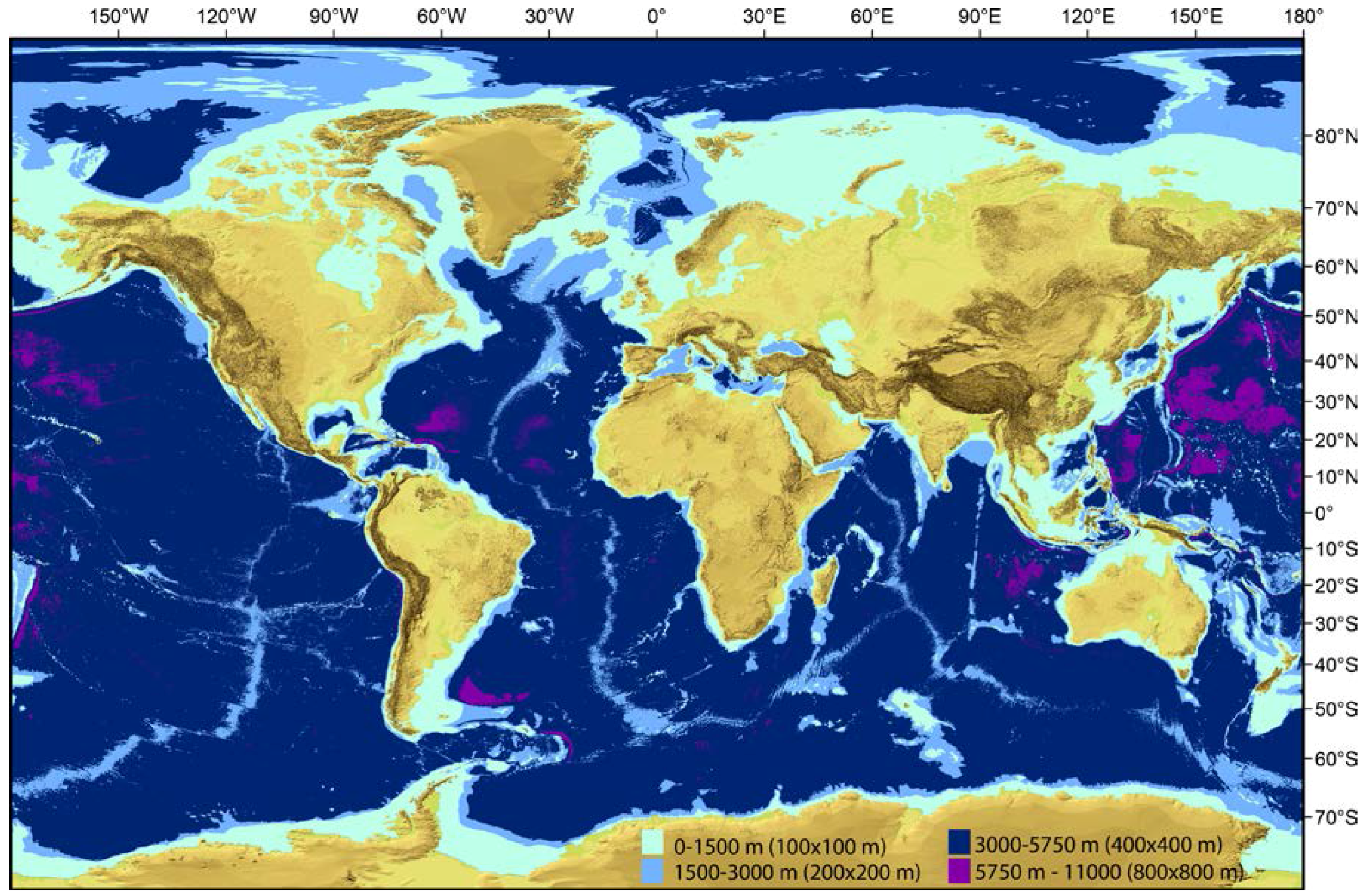
The photo shows the projected warming per year (indicated by the color-coded bar on the right) of the world's Marine Protected Areas (indicated by the black dots).

Yet momentum is now building to protect the high seas.
This September in New York City, negotiations begin on a United Nations treaty — which is likely to be an add-on to UNCLOS — to agree on how to safeguard this vast shared resource by setting aside areas for conservation and laying out rules for activities such as deep-sea mining.
The treaty could also find ways to help all countries benefit from research into deep-sea species — including whether marine organisms’ genes and proteins might form the basis of new drugs or materials — either financially or through technology transfer.
The talks are being heralded as a Paris climate accord for the oceans: a vital opportunity to conserve the planet’s least-explored realm.
“We have a once in a lifetime chance to secure a treaty that will allow nations to manage activities on the high seas,” says Lance Morgan, president of the non-profit Marine Conservation Institute in Seattle, Washington, which is focused on ocean protection.

The UN, regional fisheries organizations and non-profit agencies have already shortlisted numerous international marine regions that — like the Sargasso — deserve protection.
But researchers are unsure whether politicians will heed scientific advice in choosing what to protect, and in making judgements about environmental impacts.
Ahead of the negotiations, Nature lays out this guide to protecting the high seas, and the scientific debates at play.

How to cordon off the oceans

A major focus of the treaty will be to agree a process to create marine protected areas (MPAs) — regions that are off-limits to at least some kinds of commercial activity.
Established properly, MPAs can boost biodiversity in previously decimated regions.
They can’t stop plastics entering the ocean, or waters becoming hotter or more acidic, but they can increase the size and diversity of marine populations, giving them a greater resilience to these stressors.

Scientists say that at least 30% of the global ocean, distributed evenly between ocean ecosystems, should be cordoned off to avoid a mass extinction of marine life.
On paper, almost 7% of the ocean is now protected: in the past 3 years, 13 of the world’s largest MPAs, all more than 100,000 square kilometres in area, have been created in coastal waters — largely impelled by a UN goal to protect 10% of the ocean by 2020.
In practice, however, these protections are often less than adequate.
To be effective, MPAs need key traits: they must be ‘no-take’, or completely off-limits to commercial activity; have an area of at least 100 square kilometres; be permanent and physically isolated from their unprotected surroundings by deep water or sand; and have well-enforced protections.
An analysis of 87 MPAs found that those with only one or two of these traits were ecologically indistinguishable from fished sites.

Many coastal MPAs allow for oil and gas exploration, shipping and fishing.
Only 2% of the ocean is no-take, and these MPAs are mostly in deep tropical waters of little interest to industry, so do little to reduce overall exploitation of the ocean.
As for the high seas, just 0.5% is off-limits to commercial exploitation.
(Much of this is due to the largest international MPA, in the Ross Sea off Antarctica, which was created by a regional 25-nation council).
“As is often the case closer to shore, there’s a serious risk that high-seas MPAs will be sited in areas of low commercial interest,” says Elizabeth De Santo, an environmental-management specialist at Franklin and Marshall College in Lancaster, Pennsylvania.
How scientific advice on MPAs will feed into the UN treaty is yet to be decided.
But debates about coastal MPAs suggest that scientists’ fears of being ignored are well-founded.
In the planned Laurentian Channel MPA off the coast of Canada, for example, it’s possible to drill for oil and gas in almost 90% of the reserve, against scientific advice.

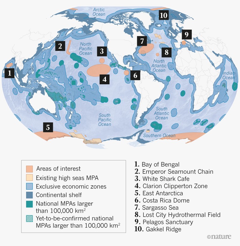
There’s no shortage of ideas for marine protected areas (MPAs) on the high seas.
UN organizations have listed dozens of vulnerable ecosystems, as have regional fisheries bodies and non-governmental organizations.
This map highlights ten sites that showcase the diversity of ecosystems on the high seas and the range of threats they face.
Data came from the Marine Conservation Institute, which has an interactive version at go.nature.com/2hlkked.
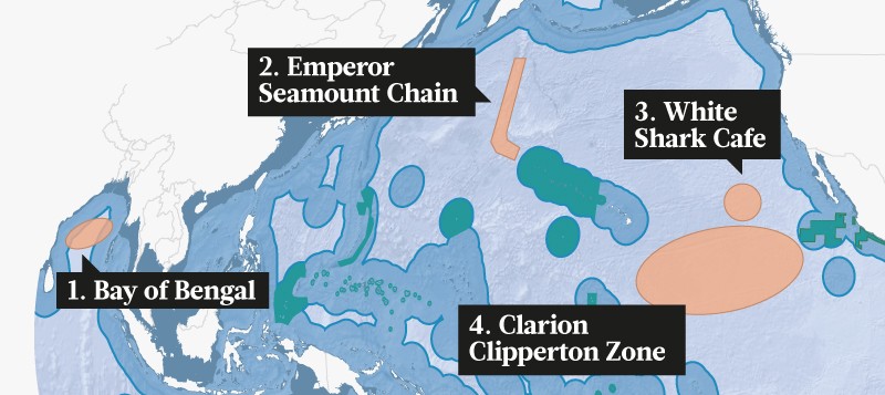
1. Dead zones.
Pollutants from agricultural runoff can cause plankton blooms in the Bay of Bengal, a shallow, warm part of the Indian Ocean.
The blooms suck up oxygen, leaving dead zones that total at least 60,000 square kilometres.
Further runoff or a change in monsoons could cause huge-scale oxygen depletion, radically changing an ecosystem that provides jobs and food security to more than 100 million people.

2. Coral crunch.
Between the Hawaiian and Aleutian islands, a chain of deep-sea volcanoes provides nutrient-rich waters for migrating albatrosses, whales and tuna.
Corals and fish have been hit hard by trawling and are struggling to recover.

3. Shark cafe.
Hundreds of great white sharks (Carcharodon carcharias) forage and breed here, in a region at risk from fishing and shipping.
These sharks are a genetically distinct population and of higher concern even than other great whites; the species as a whole could number as few as 3,500 in the wild.

4. Sea-bed mining.
Scattered on and below the sea bed are trillions of nodules — potato-sized, rock-like deposits rich in many valuable minerals.
But the region also hosts rare marine species, including a species of ghost octopus that was discovered in 2016.
The International Seabed Authority has issued 16 contracts to explore the area for minerals.
Scientists say at least one-third of the zone should be off-limits to mining, with controls in place where it is permitted.
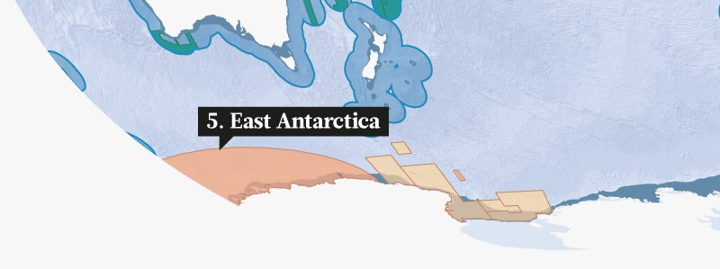

5. First new MPA?
East Antarctica, a relatively pristine ecosystem that is home to Adélie (Pygoscelis adeliae) and emperor (Apterodytes forsteri) penguins, the seas here are rich in cold-water corals.
This region is also the origin of Antarctic bottom water, a cold, dense and oxygenated water mass that drives the circulation of the global ocean.
All this amkes it a clear choice for a high-seas MPA.
But China and Russia have interests in fishing krill here; in 2017, it was rejected as an MPA for the sixth consecutive year by the Commission for the Conservation of Antarctic Marine Living Resources.
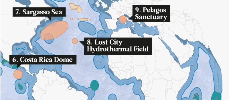

6. Dynamic dome.
Strong winds drive currents that force cold, nutrient-rich waters to well up from the deep to just below the surface.
Iconic ocean species come here, including mahi-mahi, billfish, sharks, squid, cetaceans and endangered sea turtles.
But this ‘thermic dome’ shifts its position, and only seasonally occurs on the high seas, so it is challenging to protect.

7. Marine rainforest.
The Sargasso region is one of 37 EBSAs, or ‘Ecologically or Biologically Significant Marine Areas’ on the high seas.
The UN designation identifies the regions as important to healthy ocean function but does not protect them.

8. Hydrothermal field.
Discovered in 2000, the ‘Lost City’ system could give clues to the necessary precursors for life on Earth.
At a depth of 800 metres, this acidic, hot ecosystem extends for about 400 metres along the top of an underwater mountain known as the Atlantis Massif.
The United Nations Educational, Scientific and Cultural Organization has proposed a 20-kilometre buffer zone.

9. Ineffective sanctuary.
This refuge, regarded as the first ever high-seas MPA, was created in 1999 to protect the many cetacean species that visit its waters.
But the sanctuary lacks management and has had little effect.
If expanded and implemented properly, it could provide refuge for bluefin tuna, sharks and swordfish.
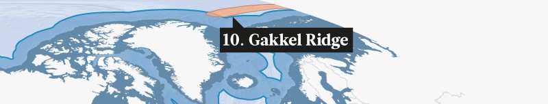

10. Oil and gas.
This 1,800-kilometre mountain chain hosts active volcanoes, hydrothermal vents and unique creatures such as eyeless shrimp (Rimicaris exoculata), which could be vulnerable to shipping and oil and gas exploration as the Arctic warms.


Monitoring and enforcement

Once protected ocean areas have been agreed on, it’s crucial to gather baseline data.
A 2000–10 project called the Census of Marine Life provided much of what researchers know about life in the high seas, but the oceans have become warmer, more acidic and more heavily fished since then.
This need for new data could stimulate a fresh period of discovery.
“A new treaty could focus international attention on the critical need to explore, understand and monitor these common ocean areas,” says Patrick Halpin, a marine ecologist at Duke University in Durham, North Carolina.

Monitoring breaches of protected areas is possible thanks to satellite technology.
Global Fishing Watch (GFW), a satellite-based surveillance initiative that was launched in 2014 by the non-profit organizations SkyTruth and Oceana, together with Google, allows anyone with WiFi access to track fishers in real time, for instance.
These data suggest that commercial fishing reaches more than half the ocean, spanning an area four times that covered by agriculture on land.
A similar initiative, called Project Eyes on the Seas, was created in 2015 by the Pew Charitable Trusts in Philadelphia, Pennsylvania, and Satellite Applications Catapult in Didcot, UK.

But prosecuting regulatory breaches is a political issue — and at the will of individual nations.
An analysis of hundreds of coastal MPAs has found that staffing and budgets are the strongest predictors of whether an MPA will have a conservation impact.
The ecological effects of MPAs with enough staff to patrol and monitor activity within the reserve were nearly three times greater than were those of MPAs with inadequate capacity, researchers found.

Environmental assessments

On land and in coastal waters, new commercial activities have to undergo an ‘environmental impact assessment’ or EIA, to weigh up any benefits against potential harm to local wildlife.

On the high seas, only some activities are regulated in this way.
It wasn’t until 2006 that bottom trawling — a highly destructive fishing method — needed an EIA.
Before that, it destroyed deep-sea corals.
Even now, mid-water fisheries, open-water farming and rocket launches (which dump waste at sea) do not need to consider potential environmental harm.
Scientists want to see new commercial activities on the high seas tightly regulated.
Deep-sea mining, in particular, is likely to cause a flashpoint at the UN talks.

The International Seabed Authority, established by UNCLOS, has approved 29 exploration licences for companies such as Lockheed-Martin to do surveys, mostly along ridges in the oceans and at hydrothermal vents.
It is now developing regulations for what EIAs mining companies would have to conduct.

Cindy Van Dover, a deep-sea biologist at Duke University in Durham, North Carolina, says that scientists are concerned these regulations will not be strict enough.
One unresolved issue is whether companies can mine active hydrothermal vent sites.
Nautilus Minerals in Toronto, Canada — the company likely to begin the first deep-sea mining operation — is targeting active vents in Papua New Guinean waters, giving rise to concerns that this might also happen on the high seas.
Active vents support large, diverse biological communities.
Generally, more than 60% of species are unique to a single vent site, and within an ocean region, vents share just 5% of species.
“We’re arguing that we should protect active hydrothermal vents,” she says.
Scientists don’t yet know whether these communities can recover from mining.
“What we’ve learned from bottom trawling is that the recovery time, particularly for complex habitats like deep-water corals, can potentially be hundreds of years,” says Paul Snelgrove, a deep-sea biologist at the Memorial University in St Johns, Canada.
Snelgrove spoke to delegates at a preparatory meeting for the UN negotiations that took place in April in New York.
“I think we have to accept that science will not be the only deciding factor, but we certainly hope it will be one of the major considerations,” he says.

Links :

Monday, May 28, 2018

CSIRO probe reveals Bass Strait shipwreck after 'chance encounter'

A digital image of the wreck discovered while "lawn mowing" the sea floor
Image : CSIRO.au

From ABC by Rhiannon Shine

Scientists scanning the bottom of Bass Strait in a "lawn-mowing" operation have stumbled on an 1890 shipwreck and uncovered more than they expected.


The CSIRO has released footage of the wreck, which was first detected last year as a "blip" in waters between Tasmania and Victoria.

The footage comes from scientists onboard the research ship Investigator as it makes its way down Australia's east coast, surveying more wrecks along the way.


The Marine National Facility research vessel Investigator is equipped with the advanced geoscience equipment to take a range of measurements of the sea floor and beneath.
This animation includes a list of the equipment and the capabilities available to scientists who use the vessel.

After last year's discovery, volunteers from the Maritime Archaeological Association of Victoria visited the site and identified it as the barque Carlisle.
Heritage Victoria senior maritime archaeologist Peter Harvey said the Carlisle was a 26-year-old collier which was bound for Newcastle from Melbourne in 1890 when it sank.
"When it got to Newcastle it was intended to pick up coal and take it to South America," he said.
"As they were going along everything seemed to be going normally but at some point they struck rocks about seven o'clock in the evening."

The Carlisle was built in England in 1864 and had crew of 23 who all survived the wreck.
Supplied: Heritage Victoria

The 23 crew had to abandon ship and jump into three life boats when the Carlisle started taking on water.
"One [boat] had most of the crew and it headed for Port Albert, but it missed and ended up about 26 miles down the 90-mile beach towards the east," he said.
"And the other one with the smaller crew went on and eventually got to Cliffy Island and they waited there at the lighthouse. They stayed there with the lighthouse keepers until they were rescued by a ship from Melbourne."

Ship hit 'mystery' rock

Mr Harvey said a marine inquiry later exonerated the ship's captain of any wrongdoing.
"The marine inquiry found that the captain did everything right and he had probably hit an uncharted rock that was about seven miles east of Crocodile Rock," he said.

There was no loss of life when it sank but it now teems with marine life.
(Supplied: National Shipwreck Database)

"If [it did], that rock would be currently in the main shipping lane between Melbourne and News South Wales today.
"So it looks like he got off on the benefit of the doubt and in fact it had been a navigation error."

 Crocodile rock with the GeoGarage platform (AHS maps)


Wreck picked up on 'lawn-mowing' exercise

CSIRO hydrographer Matt Boyd, who discovered the wreck while on an Investigator voyage last year, said it appeared as a "blip" while he was conducting routine mapping of the ocean floor.
"The way this survey works, it is very monotonous kind of stuff, very repetitive, we call it 'mowing the lawn'," he said.
"We are sort of going back and forth for long periods of time over large areas of seabed.
"We just happened to go over this blip and we noticed it and thought 'oh jeez that looks just a little too much like a shipwreck' and so we did a little bit more investigating and looked at it digitally.

Shipwreck in Bass Strait
The ship hit rocks south-east of Wilsons Promontory in Tasmanian waters.
Supplied: National Shipwreck Database 

Then once we established that yes it was a shipwreck we put a drop camera down.
"That is the exciting bit — that unknown of what it could be and what happened to it."
Mr Harvey said it was an exciting discovery.
"The condition is degraded but as an archaeological site it is intact, so really important to us to give us an opportunity to look at a site that hasn't been disturbed before," he said.

More shipwrecks found off east coast

Matt Boyd has been at sea this week onboard the Investigator, which is on a week-long voyage from Brisbane to Hobart and has mapped two more shipwrecks.
One of the wrecks was HMAS Pioneer and the other was unidentified.

HMAS Pioneer was scuttled off Sydney Heads in 1931.
Supplied: State Library Victoria

Originally constructed for the British Royal Navy in 1900, the light cruiser Pioneer was later gifted to the Royal Australian Navy.
After serving in World War I, it was used as an accommodation ship before being scuttled off Sydney Heads in 1931.


Fits dive of Andrew Johnstone on the Ex HMAS Pioneer (67mtrs)...
only circumnavigated the aft third.
Still allot of wreck to investigate.

The Australian National Maritime Museum's Emily Jateff, who was on board the voyage to help with the shipwreck mapping, said the unidentified wreck was an exciting find.
"RV Investigator has the capability to do a close resolution multi-beam survey which allows us to located shipwrecks in almost a single pass," she said.
"The wreck is at this point pretty unidentified. We have vague dimensions — about 67 metres in length and about 11 metres across.
"It could be another naval vessel. Quite a number of naval vessels were scuttled off the coast during WWI and WWII. But we will just have to wait and find out."

Links :

Sunday, May 27, 2018

Volvo Ocean Race: 24 Hour record falls


How to fly a drone in 30+ knot winds 
Go behind-the-scenes with OBR Sam Greenfield as he launches his DJI drone in brutal Atlantic Ocean conditions.
Bonus: Kyle catches drone ...while driving! (yes really)


Team AkzoNobel set a new record for the greatest distance sailed in 24 hours in the history of the Volvo Ocean Race today, eclipsing the previous mark and smashing past the 600-mile barrier (602.51 Nm, average boat speeds above 25 Knots) as they rocketed through the North Atlantic.
By the way, 6 of 7 teams beat the previous record on this current leg :
Dutch skipper Simeon Tienpont’s crew on their Volvo Open 65 bested the existing record for a yacht competing in the Volvo Ocean Race, the 596.6 miles set by Torben Grael’s Volvo Open 70 Ericsson 4 in the 2008-09 edition.

Saturday, May 26, 2018

Levitation : foiled moth fly in the archipel des Glénans

Charlie Dalin, a french offshore sailor foiling with his moth across tiny islands of Brittany. 

photo from video : Hocus Focus media

Iles des Glénans with the GeoGarage platform (SHOM nautical chart)

Friday, May 25, 2018

New proof for Kon-Tiki theory – archive, 1953


Some film extracts from the ''Kon-Tiki Expedition'' of 1947.
The six man Norwegian crew who sailed 6,900 km across the Pacific (from Peru), was led by Thor Heyerdahl.
''Kon-Tiki'' was the name of the raft which was made from balsa wood and bamboo, and held together with ropes,
The voyage across the Pacific ended when the raft became stranded on a coral reef 6,900 Kilometres from the port in South America, from which they set out 101 days earlier.

From The Guardian

18 May 1953: Thor Heyerdahl demonstrates the raft that sailed across the Pacific and tells Princess Margaret about new evidence that inhabitants of the Polynesian Islands originally came from South America

Princess Margaret’s visit to Oslo as a guest at the wedding of Princess Ragnhild and Mr Erling Lorentzen, a shipping director, has been a resounding success.
The Princess has attracted far more attention than any other of the many royal guests, and newspapers all over Scandinavia have been full of praise for her qualities as an ambassador of goodwill.
Her activities have been front-page news in the Scandinavian press even after the wedding.

The Princess has visibly enjoyed her stay and has been able to give a personal touch to her visit.
One of the highlights of her programme was a visit yesterday to the Kon-Tiki Museum, where the explorer, Thor Heyerdahl, not only demonstrated the famous raft and equipment but also gave the Princess new first-hand information of his findings during a recently completed second tour in Pacific waters.

 Le Breton, "pirogue des mers du Sud" (1846)

Heyerdahl nears end of voyage


Mr Heyerdahl now claims that he has found the last links in the chain of proofs of the theory that inhabitants of the Polynesian Islands originally came from South America.
One of the main points in criticism of the theory has been that no signs had been found of South American settlement on the Galapagos Islands, which should be far easier to reach with rafts than the Polynesian Islands which are much farther away.

The expedition of Norwegian anthropologist Thor Heyerdahl travelling across the Pacific on the balsa raft Kon Tiki circa 1947.
Photograph: Hulton Getty

During his latest expedition Mr Heyerdahl went to the Galapagos in company with American and Norwegian archaeologists and found traces of four South American settlements.
A great number of pots and tools, some of which were from the Inca period, were brought home.

That South Americans never settled permanently on the Galapagos is, according to Mr Heyerdahl, explained by a new and important discovery that balsa wood rafts of the Kon-Tiki type were manoeuvrable so that a return journey was possible.
When he set out on his first expedition Mr Heyerdahl believed that the raft was forced to follow the winds and currents, but he has now been able to prove personally that rafts can cruise almost like an ordinary sailing-boat.


The Kon-Tiki raft was constructed in accordance with old designs and equipped with one pair of centreboards forward, one pair aft, and one pair amidships, but the centreboards were not – as Mr Heyerdahl first believed – meant only to steady the raft.
By raising or lowering the front or rear centre-boards and adjusting the sail, direction could be changed without using oars or rudder.
This method was used by Indians until fifty years ago but has since been forgotten and Mr Heyerdahl got to know about it by chance.
This time he sailed out on a new raft from the Ecuador coast in a favourable wind but had no difficulty in returning to his starting-point.

Links :

Thursday, May 24, 2018

Rise of the seabots


From Hana Hou by Tom Koppel

A new generation of marine robots is surveying the world’s oceans

The big diesel purrs as we cruise along four miles off Kawaihae.
Three volcanoes dominate the horizon, and tradewinds curve around the northwestern tip of Hawai‘i Island.
Our boat closes in on what resembles a surfboard with a short mast, navigation lights, two antennas and solar panels.
This is the “float”: the surface portion of a marine robot developed here on the Kona coast.

Tony San Jose, who’s leading our outing, signals us to don our snorkel gear as the boat pulls alongside.
We slide over-board and gaze into the indigo abyss, then swim to the float and grab onto its handles.
This is a Wave Glider—number sixty-three out of some four hundred built to date—and it’s been hovering out here for months.
I pick off a soft, young barnacle growing on the underside.
“Those are a delicacy in Spain,” Tony quips.

The Wave Glider is an autonomous robot, powered by waves and solar energy, that collects and transmits data about the ocean in real time.
It was created by Sunnyvale-based Liquid Robotics.

Hanging twenty-four feet below the surface float and connected by a black umbilicus is the “sub,” a narrow contraption with twelve horizontal fins.
As waves lift the float at the surface, the attached sub gets tugged up and down, causing the fins to undulate.
This creates propulsion by which the sub tows the float.
The sub is equipped with a rudder and a battery-powered thruster to provide a boost whenever the sea is dead calm or the glider encounters a strong current.
Guided by satellite and harnessing the ocean’s energy, a Wave Glider can stay at sea for up to a year and cross oceans without consuming fuel or producing any emissions.
And Wave Glider is just one of several marine robots that have been revolutionizing ocean exploration and research in the last ten years.

Engineer Billy Middleton flutter-kicks effortlessly down and clings playfully to the sub.
The float pulls us along as it traces lazy circles, holding station within a small, GPS-defined pixel of the Pacific.
If the robot wanders, satellite commands will return it to its box.
Within a mile or so are six other Wave Gliders, each assigned to its own square by Liquid Robotics.
Founded in 2007, Liquid Robotics was acquired by Boeing in 2016 and most of its operations moved from Hawai‘i to Sunnyvale, California.
But Kawaihae remains its testing ground.
Personnel from government agencies and other clients, including the US Navy, come to the Islands for courses in operating the gliders they’ve purchased.
Base model costs around $250,000 (more with custom instrumentation).

At its start Wave Glider wasn’t the sophisticated robot it’s become.
In 2003 Joe Rizzi, an engineer and former Silicon Valley venture capitalist, was trying to record the songs of the humpback whales that winter around Hawai‘i.
But the hydro-phones he’d affixed to buoys kept breaking loose.
Rizzi needed something better, an “unmoored, station-keeping data buoy,” as he describes it.
A small tech team led by Roger Hine, whose background is in engineering as well as robotics, took on the challenge, embarking on what would be a two-year period of trial and error.
Hanging on the wall of the shore facility at Kawaihae are funky, weather-worn components of early Wave Gliders.
Instead of fins, “the first sub had double whale’s tails,” says Chuck Shaver, the longest-serving techie of the group.
In the end Rizzi and Hine developed much more than a stationary floating listening device: Wave Glider could propel itself, even in rough seas, at up to two and a half knots.
In 2009 a Wave Glider circumnavigated Hawai‘i Island.
Then two of them crossed from Hawai‘i to San Diego in eighty-two days.
It was a historic achievement: the first long-distance transit by an ocean robot relying on renewable energy.

I first came across autonomous marine technology in November 2013, at the Kaneohe Yacht Club on O‘ahu.
Hunched over the hatch of a nineteen-foot, life-jacket-orange sailboat was none other than Richard Jenkins, the British engineer who had famously set the land-sailing world record of 126 mph on a dry lake bed in California.
Jenkins had designed the fixed-wing sail that propelled his Greenbird himself, and having worked in an English shipyard and sailed offshore as well, it was only natural that he’d apply the design to a boat.
Tinkering beside Jenkins was Dylan Owens, an American with whom Jenkins developed Saildrone using seed money from Google’s power couple, Wendy and Eric Schmidt.


Schmidt Ocean (May 4, 2018)
“I think that that what we will see as the platform matures, people will be flocking in and recognizing there is more and more and more purpose for this particular platform.
So I think we’ve seen just the tip of the iceberg at this point.”
Some of the most exciting and innovative technologies being used on the WhiteSharkVoyage are the saildrones.
Take a look at how these autonomous wind and sun powered vehicles are expanding data gathering and research in this video, and access the real-time data with the following links: http://ferret.pmel.noaa.gov/soi/las/ / http://ferret.pmel.noaa.gov/soi/erddap/


A Saildrone near its home base in San Francisco.
Last summer, three Saildrones completed a joint NOAA/NASA research cruise to the Arctic, transiting the Bering Strait—a first for autonomous vehicles.

Saildrone is a robotic craft with a rigid sail and solar panels to charge batteries for steering and satellite communications.
“She just arrived from San Francisco yesterday,” Owens told me proudly, “after thirty-four days at sea.”
 Later that day, a boat towed the vessel out beyond Kāne‘ohe bay to continue its journey south toward the equator, a cruise that would last several months.

Since then Saildrone has gotten bigger —twenty-three feet—and faster, attaining speeds of eight knots.
It has weathered a hurricane in the North Atlantic and measured salinity along the melting pack ice north of the Bering Strait.
In September, on a mission for NASA, two Saildrones headed into equatorial waters to test whether they might be useful in forecasting El Niño events.
About twenty have been built so far by Saildrone, Inc. in Alameda, California.
Rather than being sold like Wave Gliders, Saildrones are hired—deployed and remotely controlled by the company to gather data on behalf of government agencies, universities and other clients at a cost of $2,500 per day.

Both Wave Glider and Saildrone can perform fundamental ocean science tasks that must otherwise be done by research ships costing $35,000 per day and up.
Marine drones are already supplementing, and might eventually replace, the scores of expensive-to-maintain moored buoys that monitor weather and detect tsunamis.
But Wave Glider and Saildrone function only at or slightly below the surface.
Taking the ocean’s pulse at depth requires an undersea rover such as Seaglider.

At a dockside lab in Honolulu, where the University of Hawai‘i at Mānoa keeps its oceanographic research vessels, electronics engineer Steve Poulos services and operates the three Seagliders UH has owned for a little over a decade.
Lying in a cradle is one of the sleek, five-foot-long Seagliders; it looks like a cartoon rocket ship, with a pointed nose, swept-back wings and an antenna for its tail.
Originally developed by the University of Washington’s Applied Physics Laboratory, Seaglider is marketed today by Kongsberg Maritime.
Some 175 have been sold for around $160,000, plus instrumentation.

Seaglider uses changes in buoyancy to dive and create propulsion.
Part of its inner hull is an oil-filled bladder that can expand and contract.
When it’s floating at the surface, oil is released into an internal reservoir; the bladder contracts, reducing the volume of water displaced by the hull, and the Seaglider sinks.
The wings tip it forward, and it dives along a slope of ten to forty-five degrees to a maximum depth of 3,300 feet, recording salinity, temperature, density and other properties along the way.
To surface, oil is fed back into the bladder, which increases Seaglider’s buoyancy.
It slowly ascends while continuing to move forward.

“Every time it’s back on the surface, it phones home,” says Poulos.
It raises its antenna, reports its position, uploads its data and checks for new commands via satellite.
After a few minutes, Seaglider is ready to dive again, repeatedly for days and weeks.
It isn’t equipped with solar cells, but the energy demand on its lithium batteries is so low that typical missions last several months.

There are a number of other undersea robots in operation, notably Slocum Glider and Spray, which differ slightly in how they alter buoyancy.
A more recently commercialized British wave-powered surface robot, the AutoNaut, has a very different design from Wave Glider.

Propelled by wave motion and powered by solar cells, a Wave Glider can remain at sea for months at a time, recording temperature, salinity, air pressure, humidity and winds via sensors installed on its surface float.

Surface and deep-sea drones sometimes complement each other.
Back on shore at Kawaihae, following our swim with the Wave Glider, Shaver recalls how, in 2010, after the BP oil rig disaster in the Gulf of Mexico, “we started doing water quality monitoring in a pretty large area with four to six Wave Gliders.”
At the same time, a Seaglider was used to detect oil pollution deep below.
Wave Gliders and Saildrones have both worked to track the movements of large ocean creatures.
Marine biologist Barbara Block of Stanford University tracked great white sharks off California with a Wave Glider.
Scientists from Dalhousie University have deployed Wave Gliders to track endangered Atlantic right whales off Nova Scotia.
Last summer a Saildrone spent weeks following tagged female fur seals in the Bering Sea when they left their pups on remote St. Paul Island to feed.
Once, a young seal climbed aboard and hitched a ride (a Saildrone camera captured the scene).

In Hawai‘i, Seagliders have become an important tool for UH oceanographers, expanding their reach and providing a more refined picture of the undersea environment.
One focus is Station Aloha, an area of deep ocean sixty miles north of O‘ahu.
Nearly every month since the 1980s, UH research ships have spent several days there creating an invaluable, decades-long data set.
Since 2008, Seagliders have been sent out to the larger surrounding area every few months to record a variety of physical and biological properties at differing depths.
These missions, often lasting two months or longer, generate a wealth of basic data in three dimensions and over a prolonged time frame.

Wave Gliders provide an essential link to connect seafloor to space nearly anywhere in the ocean.
See how the Wave Glider relays information from underwater back to shore.

Wave Glider was conceived by entrepreneur Joe Rizzi, who wanted a device to record singing humpback whales.
Rizzi along with engineers Derek and Roger Hine, tested models in aquariums and swimming pools.
“Bit by bit,” says Roger, “we ended up with a ocean vehicle that could hold station, collect data and communicate the singing of the whales to shore!”

Benedetto Barone, a UH scientist who specializes in microbial oceanography, relies heavily on Seaglider.
He studies biological processes in the sea, such as photosynthesis, and their impact on microscopic organisms critical to the food web.
“My primary interest,” he says, “is how the motion of water impacts the life within that water.”
The ocean around Station Aloha is moving almost constantly, as great rotating eddies a hundred miles across or larger sweep slowly past, some churning clockwise, others counterclockwise.
“They are the most important motions in the ocean,” Barone says, affecting, for example, sea surface height, which can vary by five or more inches above or below average.
This, in turn, has surprisingly strong effects on phytoplankton production even hundreds of feet below.
Barone likens these ocean vortices to hurricanes or typhoons in the atmosphere.
His computer displays dramatic false-color images of these huge pelagic storms, which Seagliders are uniquely suited to studying.
Barone can ask Poulos to program a Seaglider to sail back and forth across the interface between these great eddies for months, weaving a cat’s cradle of survey lines.
Each dive uses sensors like the chlorophyll fluorometer to measure the biomass of phytoplankton at different depths in the water column, generating a high-definition, three-dimensional picture of where food production is concentrated.
This could never be done from a stationary ship or one cruising through for only a few days.

The coming decades will likely see thousands of marine drones patrolling, or holding station, at every watery longitude and latitude.
“There is very high demand,” says Saildrone COO Sebastien de Halleux, “and no shortage of countries and populations that have the same questions” about marine science.
“Everyone is developing their own niches.
We’ve only scratched the surface of what is possible.”

Links :

Wednesday, May 23, 2018

Mappers look to chart world's ocean floor by 2030


From Reuters by Jonathan Saul

Using data collected from underwater drones, merchant ships, fishing boats and even explorers, a new scientific project aims to map the ocean floor by 2030 and solve one of the world’s enduring mysteries.

With 190 million square km (73 million square miles) of water - or about 93 percent of the world’s oceans with a depth of over 200 meters (650 feet) - yet to be charted, the initiative is ambitious.

Depth regions based on state-of-the-art 2° × 2° deep-water multibeam installed on surface vessels

Satinder Bindra, director of the Seabed 2030 project, said the work can be completed within the period and will shed light on everything from tsunami wave patterns to pollution, fishing movements, shipping navigation and unknown mineral deposits.
“We know more about the surface of the Moon and Mars than our own backyard. This in the 21st century is something that we are working to correct,” Bindra told Reuters.
“For too long now we have treated our own oceans as a forgotten frontier.”

The project is a collaboration between Japan’s philanthropic Nippon Foundation and GEBCO, a non-profit association of experts that is already involved in charting the ocean floor. GEBCO operates under the International Hydrographic Organization and UNESCO, the United Nations cultural agency.
“We are not driven by profit, we are driven by science,” Bindra said.
“There’s unanimity within the scientific and the mapping community that a map is essential.”

Still, the ocean economy is expected directly to contribute $3 trillion to the world economy by 2030 from $1.5 trillion in 2010, according to the Organization for Economic Cooperation and Development.

The initiative has received support from Dutch deep-sea energy prospector Fugro, which was involved in the search for Malaysia Airlines flight MH370, which disappeared in 2014. Fugro has contributed 65,000 square km of data.


An image of the ocean floor is seen in this graphic received via Henry Gilliver of the Nippon Foundation - GEBCO Seabed 2030 Project (Copyright Fugro), in London, Britain May 22, 2018.
The image shows color coded bathymetry showing seamounts on the seabed. Henry Gilliver of the Nippon Foundation - GEBCO Seabed 2030 Project (Copyright Fugro)/Handout via REUTERS


Ocean Infinity, which has taken up the search for MH370, is another company contributing to the 2030 initiative.

Bindra said they are also looking to tap research missions as well as explorers searching for sunken wrecks together with data pulled from ships, fishing boats and commercial companies.

The project, which has an estimated cost of $3 billion, will leave waters closer to shore to national research bodies. The U.S. National Oceanic and Atmospheric Administration is separately supporting the initiative.

One potential problem such exploratory research could face would be from rising geopolitical tensions in sensitive waters around the world including the South China Sea, the Gulf of Aden and the Red Sea.

An image of the ocean floor is seen in this graphic received via Henry Gilliver of the Nippon Foundation - GEBCO Seabed 2030 Project (Copyright Fugro), in London, Britain May 22, 2018.
The image shows a side scan sonar image of a sunken vessel on a seabed.
Henry Gilliver of the Nippon Foundation - GEBCO Seabed 2030 Project (Copyright Fugro)/Handout via REUTERS

“By being open in our data sharing, we are also hoping that national hydrographic organizations will start sharing their data and closer to shore,” Bindra said.
Bindra said the data obtained from the multiple sources would be pulled together by experts at four centers around the world and then collated at Britain’s National Oceanography Center, adding that they planned to produce their first bathymetric map by the end of 2018 and update it annually.

Peter Thomson, the U.N. secretary general’s special envoy for the ocean, said he was “very aware ... of the mineral aspects” of exploring the seabed, adding that the main charting activity would be from the scientific community.
“The United Nations has adopted a resolution to have a decade of ocean science for sustainable development running from 2021 to 2030. And during that decade I’m very confident we will have totally mapped the floor of the ocean.”

Links :

Tuesday, May 22, 2018

Bolivia is landlocked. Don't tell that to its navy

Sailors who join Bolivia's navy don't see much of the world.
They've been land locked by the Andes mountains of South America for the past 125 years.
That's when Bolivia went to war with neighbouring Chile and lost access to the Pacific Ocean.

From Wired by Laura Mallonee

In the US, joining the navy means getting to see the world. But in Bolivia, recruits just hope they might one day get to see the ocean.

That’s because this landlocked country doesn’t have access to one.
At least, not anymore: During the War of the Pacific, a land fight with Chile that lasted from 1879 to 1883, Bolivia ceded all 250 miles of its coastline.
It's a devastating loss; officials still describe it as a "historical injustice," and Bolivians mark the official Day of the Sea each March.

Treaty of Peace and Friendship between Bolivia and Chile of 1904$
Bolivia is not reconciled to the loss.
The poorest country in South America, it blames its plight largely on its landlocked condition  

In fact, the country never stopped trying to get its shoreline back, arguing that lack of direct access to the sea has hurt Bolivia's economy.
The country can use Chilean ports, through which it sends two-thirds of its trade, but that’s little consolation when it used to have its own.
In 2013, the government brought its grievance to the International Court of Justice, hoping the Hague will order Chile—with whom it broke full diplomatic relations 40 years ago—to negotiate.

“The ocean and its reclamation is still very much at the front of Bolivia’s national psyche,” says Nick Ballon, a British photographer of Bolivian descent. Ballon plumbs this national obsession in his fascinating series Navy Without A Sea.

Simply by existing, the navy is the physical embodiment of Bolivia’s refusal to give up.
The government established the Armada Boliviana in 1963, acquiring four US patrol boats.
Today its humble fleet includes speedboats, tankers and other vessels, some cast-offs from China.
“The fleet they keep is bruised and battered, and they’d be the first to admit they could probably do with some newer craft,” Ballon says.

Lake Titicaca is a 3,200-square-mile body of water that straddles Bolivia's western border with Peru. It's the biggest lake in South America by water volume.
The Strait of Tiquina, pictured here, connects the lower and upper portions of the lake.
photo : Nick Ballon

But they’re more than just the military equivalent of those garage-sale skis you’ll never use.
The navy’s 5,000 troops navigate water wherever they can, sailing the country’s Amazonian rivers and Lake Titicaca, a 3,200-square-mile body of water more than two miles above sea level where Jacques Cousteau once scubaed for Inca treasure.
And its work is important: It fights drug traffickers, delivers medical supplies to remote communities and responds to disasters. Troops even joined one UN peacekeeping mission in Haiti.

Ballon became intrigued by Bolivia’s relationship with water after the Cochabamba Water War of 2000.
His father is Bolivian and lived there, so he began visiting several times a year to work on a long-term project called The Bitter Sea.
“Photography was my door to the country," he says, "which led to a deeper understanding of its people and land."

1864 Johnson's Venezuela, New Granada, Ecuador, Peru & Bolivia, Chili and Guana by Johnson and Ward


Map of Bolivia and Peru before the War of Pacific, published in New York, 1878

In October 2016, after a full year of petitioning access, he and his assistant took a four-hour minivan shuttle from La Paz through the arid central Andes to San Pedro de Tiquina.
There, a white-uniformed captain handed them life jackets before steering them 20 minutes up a narrow strait to to the Tiquina Naval Base on frigid Lake Titicaca.
A statue of Bolivian war hero Eduardo Albaroa—whose last words “Surrender?
Your grandmother should surrender, fuck!” are quoted throughout Bolivia—stood near its entrance, with the assurance, “What once was ours, will be ours once more.”

Ballon embedded at the base for a full week, spending most his time documenting teenage female recruits undergoing a 13-week tactical course at a high-altitude diving training center.
Their mornings began bright and early with intense physical training and a grueling swim class in an unheated swimming pool, followed by classes on scuba theory.
But to Ballon, the most fascinating element was the preparations for the base’s 48th anniversary celebration: engineers spent days polishing up the boats and tying ropes into ornate, seaworthy knots.
Hundreds of troops in blue naval uniforms and white caps marched day and night to songs like “We Will Recover Our Sea."
“It was incessant,” Ballon says.

His images, beautifully photographed with a medium format camera, capture the recruits swimming, floating, and practicing their maneuvers against a marine backdrop so enormous that on hazy days it almost looks like a sea.
One day, they hope, it will be.

Links :