
From USA Today
Flip Tayamen has seen the wetlands of his childhood disintegrate and vanish.
Still, he was stunned to hear that those bays and bayous, with names like Yellow Cotton Bay and Dry Cypress Bayou that offered him nets full of shrimp and shelter from storms, would no longer appear on maps.
"It's really painful," Tayamen, 60, a shrimper in lower Plaquemines Parish, 40 miles south of New Orleans.
"You don't know where you're going anymore. You don't know which way to point."

Photo provided by P.J. Hahn, Plaquemines Parish Coastal Zone Management Department
Locals like Tayamen have seen the slow death of Plaquemines' wetlands for years.
Over the past several months, cartographers at the National Oceanic and Atmospheric Administration have made it official, removing 40 place names from official nautical maps.
Bays, bayous, rivulets and islands like Fleur Pond, Tom Loor Pass and Skipjack Bay have been erased from federal maps.
The reason: They're no longer there.

1891 USGS map of section of Plaquemines Parish, Louisiana including Pointe à la Hache.
(1939 USGS map of section of Plaquemines Parish, Louisiana including Ironton, Myrtle Grove and Pointe à la Hache.)
New maps are redrawn all the time with new features, said Meredith Westington, chief geographer at NOAA's Office of Coast Survey, which updates maps.
But having such a high number of removals in one place – all along Plaquemines Parish – is unprecedented, she said.
"This is the first I've seen it," Westington said.
"I don't know that anyone has seen these kinds of mass changes before."
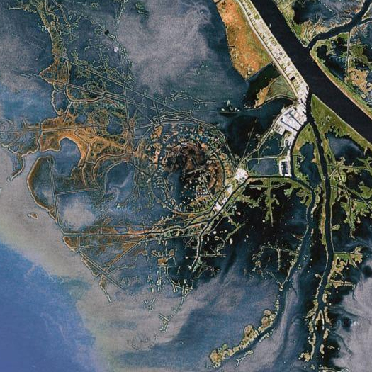
The "Wagonwheel", an unusual circular pattern of canals just south of Yellow Cotton Bay, also owes its pattern to the combination of geology and extractive logistics.
Here, the oil companies' canals depart from their typically linear vocabulary to follow the roughly circular limit of a raised salt dome.
The names – 40 and counting – will be stored in the historical record at the agency, she said.
But new maps will no longer show them.
The list got so high that Westington began keeping a running tab on her desk – the only place in the USA that she's needed to do that, she said.
A team of surveyors are still mapping the Gulf Coast and should be done later this year.
"It's a little disturbing," Westington said.
"It's sad to see so many names go."

The new maps document a disturbing trend Louisianans have witnessed for years.
The state has lost more than 1,800 square miles of its coastal marshes – an area larger than the size of Rhode Island – since the 1930s, due to sealing off the Mississippi River with levees to protect towns, natural subsidence and thousands of miles of transport canals carved out by oil and gas companies.
In another rare move, a New Orleans area flood control board filed a lawsuit last year against 97 oil and gas companies, claiming they should fund billions of dollars in coastal restoration projects for their role in wetlands loss.
Similar lawsuits by Plaquemines and Jefferson parishes followed.
Only a fraction of a $50 billion, 50-year state plan to restore the coast has been funded.

Bays, bayous on Wikimapia map
The move to make oil and gas companies liable has been fought by Louisiana Gov.
Bobby Jindal, a Republican, who refused to re-appoint members of the flood control board involved in the suit.
Garret Graves, Jindal's coastal chief, didn't return several requests for comment.

Besides the transport canals – which allow saltwater to enter and erode marshes – Plaquemines has been battered by four recent hurricanes starting with Hurricane Katrina in 2005 and the BP oil spill, which infiltrated the parish's marshes, Plaquemines president Billy Nungesser said.
His parish alone will need about $1 billion to save it from vanishing into the sea.
NOAA removing names from maps was a wake-up call to how fast the crisis is mounting, he said.
"It makes it hit home how quickly we're losing the coast of Louisiana," Nungesser said.
"With a snap of the fingers, they're gone."

A colony of brown pelicans on an island at Four Bayous Pass in Plaquemines Parish
The disappearance of those places was less of a surprise to Bradley Nezat, 49, a former fishing guide and current restaurant owner in Venice, La., at the southern tip of Plaquemines.
Years ago, taking a boat out to the gulf required motoring through stands of Cypress trees.
Today, all those trees are gone and each year the open water pushes closer to shore, he said.
"It took thousands of years to make this peninsula," Nezat said.
"It'll disappear much faster than that."
NOAA : Geographic names disappear from charts, but not from history
ReplyDelete