
John Valcarcel / Wired
From Wired by Matt Simon
At the crest of a swell, an orange wing sticks straight up out of the ocean, like the fin of a miserable orca waving to the crowd at SeaWorld.
That speck of color some 800 feet from the research vessel Paragon is part of an advanced seagoing robot, a drone, and the wing contains its antenna—which is talking to a satellite, which is talking to our skipper’s cell phone.
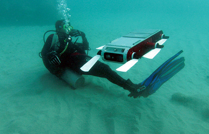
Once we’re alongside the machine, a scientist stretches to snag a loop on the 100-pound robot with a hooked pole, then starts hefting the drone up.
Another researcher grabs halfway down the body, and together the two men lug the drone aboard and gingerly place it on a stand.
It’s 6 feet long and shaped like an airliner, with two wings and a tail fin, and bears the message “OCEANOGRAPHIC INSTRUMENT PLEASE DO NOT DISTURB.”
All caps considered, though, it’s a more innocuous epigram than the one on a drone I saw back at the dock: “Not a weapon—Science Instrument.”
We’re bobbing in the sea just south of Santa Cruz, California; the Paragon is a pickup truck-shaped vessel, cabin in front and a flat deck with edges about a foot high, run by the Monterey Bay Aquarium Research Institute.
There’s no bathroom on board.
“Guys, it’s super easy. Any time, you’re welcome to go over the side,” says Jared Figurski, the MBARI marine operations division’s jack of all trades.
“Ladies just…let us know and we can set that up on the back deck too.”
While the old adage goes that scientists know more about the surface of the moon than the seafloor, that’s a two-dimensional way of thinking.
The oceans remain mysterious up and down the water column: the incredibly complex chemical and biological relationships, or how exactly the oceans are changing under the weight of global warming and other human meddling … acidity, temperatures, currents, salinity.
And the most powerful tool to help figure all that out is the drone.
MBARI has a fleet of them, three different kinds—autonomous machines that prowl the open oceans gathering data, allowing researchers to monitor it in real time.
The machines do not tire, and they cannot drown.
They survive shark bites.
They can roam for months on end, beaming a steady stream of data to scientists sitting safely onshore.
So while aerial drones may get all the love, it’s autonomous underwater vehicles like the one the Paragon just snagged that are doing the grunt work of ocean science.
They’re the vanguard of the robotization of Earth’s oceans.

Our oceans are in peril, but on this morning we were treated to an
astonishing feeding frenzy of perhaps a dozen humpback whales and dozens
of dolphins, which had found a nice bait ball to consume.
Josh Valcarcel/WIRED
Sea Change
Their arrival couldn’t come at a better time.
The oceans are in big, big trouble.
A study released in January found that we humans are on the verge of initiating a mass marine extinction with a dizzying number of threats.
Global warming is heating the oceans, forcing fish into new distributions.
The seas are absorbing the carbon dioxide we’re pumping into the air, leading to acidification that damages coral reefs.
Overfishing has decimated species.
Cargo ships are slamming into whales.
Old-fashioned pollution, oil drilling, oil spilling, Dubai building massive islands for rich idiots …
I could go on, but I’m probably depressing you.
The glider the Paragon picked up had been roaming for three or four weeks, but robots can potentially rove for six months, traveling some 2,500 miles.
It’s a simple design with an energy-saving trick: no traditional motor.
Instead, “they change their buoyancy,” says senior MBARI scientist Francisco Chavez.
“They move the center of gravity forward so they point down,” then modify their buoyancy to float closer to the surface, over and over, up and down.
In the air, a glider’s wings generate lift, relying on rising columns of air called thermals to get an extra boost.
With an underwater robot, those wings provide “lift” to keep it gliding too—without them, it’d sink straight down and bob right back up.
Buoyancy takes the place of a thermal.
The robots’ routes therefore resemble really long sine waves. And if they need to turn?
“They can move their center of mass by moving their batteries either left or right,” says Chavez.
All the while the drones collect troves of data, including temperature, salinity, pressure (a proxy for depth), and oxygen levels.
For salinity, the drone is measuring the conductivity of seawater, then using that value to calculate how much salt is present.
The oxygen sensor operates on a similar principle, passing water through a semi-permeable membrane, behind which is a chemical solution with electricity coursing through it.
The amount of oxygen changes the voltage.
And drones map the seafloor with sonar, firing sounds downward and measuring the echoes to reveal the terrain.
Not all drones are as simple as the glider.
On the other end of the spectrum is a fully motorized version, 8 feet long and almost 2 feet wide with a big propeller on the end, like a torpedo.
It can only last a few days out on its own, but while the glider is limited to depths of 650 feet, the big AUVs can dive over a mile.
Plus they can collect biological material—scales and plankton and flesh and such—by opening one of 10 spring-loaded cylinders and grabbing a water sample.
“You watch CSI, right, or something like that?” asks Chavez.
“They find the little hair or piece of skin from somebody and they run DNA analysis to see if they can prove a person is there or not. Well the same thing happens in the ocean.”
Sequencing whatever tissue the big drones pick up gives the researchers an idea of what animals are in a given area—but not how many of them there are.
Population size remains a challenge.
Rounding out MBARI’s fleet is a third, middle-ground variety.
Like the big AUV, it has a propeller, but it can also switch to the sine-wave propulsion of the glider, hitting distances of 600 miles.
This one’s referred to as a long-range AUV, and MBARI has some seriously excellent ideas for its future.
“We expect that someday the long-range AUVs will be operational in the sense that they will be able to pull into an underwater docking station, recharge, drop off whatever they have to drop off—be it data or samples—and then continue out on their mission,” says Chavez.
It’ll be like a Roomba returning to its station to juice up, only it’ll be packed with science instead of cat hair.
Oculus Primed
The fleet has collected an almost unimaginable amount of data, between mapping the seafloor and monitoring microscopic oceanic life and measuring salinity.
It’s numbers upon numbers upon numbers.
So many numbers, in fact, that MBARI had to build a whole new database to organize it all.
While we’re at it, someone thought, why don’t we just pipe the data into a virtual-reality headset so we can fly around the seafloor?
And so it was.

Back on land, MBARI software engineer Mike McCann asks if I want to be Superman.
I say OK, sure (I guess I’d be a fool not to), so he sits me at his desk and has me strap Oculus Rift virtual-reality goggles to my face.
And soon enough I’m flying through layer after layer of horizontal grids.
A motion sensor, the same sort of tech as the Xbox’s Kinect, has digitized my hands, so if I move them left or right, I turn.
Up and down adjusts my elevation, and to stop I simply raise my palms.
McCann hopes to someday replace this simple environment with a realistic model of the ocean, using data collected from AUVs. “It’s a ton of data,” he says.
“There’s millions of points, but if you want to experience them in a different way, you could just fly around Monterey Bay.”
There’s already a simple version of this, which you can see in action below.
That’s the undulating path of a drone, with the colors representing concentrations of phytoplankton (high values being red and low being purple), tiny plant-like organisms that sit at the base of the food chain, that the robot had collected.
That’s the seafloor below, imaged by a shipboard sonar system.

An Oculus Rift VR simulation showing the path of a drone,
with colors representing concentrations of phytoplankton.
Gif: © MBARI.
This VR software is the beginning of a full-blown 3-D approach.
It’s ugly right now, sure, and I’ll just come out and say we didn’t get to see the demo firsthand because a bug had crippled it, but this is the glorious manifestation of oceanic data as a 3-D “experience.”
Soon enough, scientists won’t always need to sort through line after line after line of data.
That data will be a ride.
“Well, just to be honest, it’s still very experimental,” McCann says.
“The way that it enables the scientists to look at the data is so novel, so new, that we really haven’t figured out yet how it will be useful.”
But, he adds, “the potential is great because we can create a full 3-D virtual environment with animations, and those could include vertical migrations of animals as measured by the robots”—vertical migrations being the movement of creatures at night toward the surface, then down into the dark depths when the sun comes up, then back again.
(It’s about predator avoidance. Pretty much everyone is doing it.)
Engineers at the Monterey Bay Aquarium Research Institute (MBARI) have developed a software package to help scientists visualize and understand complex oceanographic processes.
The free and open source Spatial Temporal Oceanographic Query System (STOQS) helps researchers deal with the large quantities of data produced by modern robotic platforms.
That heavy lifting fell on McCann, who developed the Spatial Temporal Oceanographic Query System, aka STOQS (pronounced “stokes”), database software that compiles and visualizes the tens of millions of data points that a single robot can collect over a month.
Instead of just listing a bunch of figures, STOQS links every figure to every other figure, allowing researchers to compile complex visualizations—a godsend when you’re trying to understand the ocean’s complicated and interconnected phenomena.
Temperature and oxygen figures are intertwined, for example (cold water can hold more dissolved oxygen), and can’t just sit isolated.
And this is all open-source, so any other institution can incorporate it into a drone program.
Efficient analysis of growing types of oceanographic observations requires new approaches in data management.
This presentation will demonstrate such capabilities using data collected for the purposes of understanding zooplankton and primary production ecology in the coastal upwelling environment of Monterey Bay, California.
McCann walks me through STOQS on his computer, clicking through all manner of measurements—actually taken a couple of years before by the very glider Paragon retrieved—visualized as bar graphs: oxygen, salinity, etc.
The salinity bit looks weird, though, with a few conspicuously red bars.
“These are obviously some data errors, probably sucked up a jelly or something and it wasn’t able to measure salinity right,” McCann says with a laugh.
He gets to a map that shows the route the glider had been programmed to follow and clicks a button that turns it into that kind of Oculus 3-D map you saw above, with the robot’s wavy path cutting through the water.
Its undulations are color-coded to show what concentrations of salinity the robot encountered at any given point.
The figures aren’t just numbers anymore, or even your average visualization—they’re the robot’s 3-D journey through Monterey Bay.
I ask McCann, “What about loading the drones with video cameras and piping that video into the Oculus?” He says, oh hell yeah—though not in those exact words—but yes, it’d be totally doable.
So just imagine, someday you might find yourself with a computer strapped to your face, drifting through the deep as bioluminescent critters pop all around you.
Then, inevitably, a giant squid will rocket up from the depths and give you a full-blown VR panic attack.
Giant squid are reliable like that.

Launching the Woods Hole Oceanographic Institution’s SeaBED AUV draws a crowd.
Hanu Singh © Woods Hole Oceanographic Institution
With a Little Help From My Friends
MBARI isn’t the only place where AUVs are changing ocean research.
Clear across the continent in Massachusetts, the Woods Hole Oceanographic Institution, home of the famed Alvin crewed submersible, maintains its own fleet.
WHOI gussied Alvin up with a slew of upgrades last year, but like the folks at Monterey Bay, its focus has been shifting toward AUVs.
Its vision for the drone-y future is different than Monterey Bay’s, though—Woods Hole researchers are focused on using drones in often dangerous shallow water expeditions, not so much sending them into the open ocean.
“We started out saying, ‘Look, we don’t want to go to the deep ocean, which is where these other vehicles go,'” says Hanumant Singh, a roboticist at Woods Hole.
“We want to work on things like archaeology. We want to work on things like fisheries, coral reef ecology. So shallower water.”
Want to count some fish or monitor penguins?
Give Woods Hole a call.
Need to explore the edge of a glacier—an incredibly dangerous task for a human, what with all the falling ice?
A robot can do it.
WHOI’s drones have monitored radiation levels around Japan post-Fukushima and determined the coastal impacts of Hurricane Sandy.
And unlike Monterey Bay’s drones, WHOI’s take video in addition to sampling things like temperature and salinity.
A smarter undersea robot (WHOI)
But this isn’t a competition.
By deploying the different techniques, Woods Hole and Monterey Bay are collecting a huge range of data.
Woods Hole is doing more immediate work, say, checking on the health of a coral reef, while Monterey is building something on a grander temporal and spatial scale.
“If we only did one, if we only did research expeditions, that wouldn’t be right,” says Singh.
“If we only said we’re only going to do these repeat surveys of the area, which is small, then that wouldn’t be right because there’s all these other phenomena that we need to understand. So I think getting that mix right is important.”
Woods Hole has open-sourced their AUV designs, and will even build the things at the request of other institutions.
“Even just 20 years ago we were very data poor in the oceans,” Singh says.
“We borrowed ships, we threw something over the side, we’d get a couple of points, and we’d feel happy. And then we started getting all of these robots.”
More and more it’ll be the AUVs that will help scientists better understand our changing seas: Monterey Bay’s gliders out taking the Pacific Ocean’s temperature and gulping up water samples, WHOI’s expeditionary drones checking in on reefs and glaciers.
And sure, at this point researchers are only touching a fraction of what’s out there.
But it’s a start.

Courtesy of Klaus Meiners, Australian Antarctic Division,
Peter Kimball, Woods Hole Oceanographic Institution
Peter Kimball, Woods Hole Oceanographic Institution
Bon Voyage, Shiny Robot Friend
Picking up an aging underwater robot isn’t the Paragon’s only mission on our trip off Santa Cruz. Lauren Cooney, a consultant with Teledyne Marine Systems, has hitched a ride to launch its latest, greatest model of glider.
It looks a lot like the one the Monterey Bay scientists collected, but it’s shinier—a brilliant yellow—and has a propeller to power it in a pinch.
As it sits on the deck, Cooney runs diagnostics on her laptop from the cabin, spinning up the propeller and such.
When it comes time to launch, the skipper ties a rope with a trailing floatie around the glider’s tail (if something goes awry, that floatie will save Cooney the embarrassment of losing a robot worth tens of thousands of dollars).
The glider is on a stretcher of sorts, two perpendicular metal poles, which Cooney and the skipper drag around, pulling one end over the edge of the boat.
Cooney picks up the other end and without fanfare hefts it up, sliding the robot into the sea.
It sinks a bit until the floatie holds it.
As the Paragon pulls away, Cooney runs still more diagnostics, testing the robot’s ballast, floating and sinking it.
When she’s satisfied, we approach again, and another scientist snags it by the rope and slices it off.
Cooney performs the ballast test once more and, satisfied, tells the skipper we can return to shore. The newest underwater robot sinks slowly under the waves, disappearing into the dark unknown.

Josh Valcarcel/Wired
Links :
- GeoGarage blog : Hundreds of floating robots could soon surveil the oceans / Fleets of sailing robots to help research & protect the oceans / Ocean drones plumb new depths / Liquid Robotics unveils Wave Glider SV3 ocean robot which brings the Cloud to the waves / Liquid Robotics to launch wave gliders to collect oceanographic data / Liquid Robotics to usher era of smart oceans with autonomous robots / Swimming robot reaches Australia after record-breaking trip
No comments:
Post a Comment