Saturday, September 13, 2014

We thought we had seen everything in freediving


We thought we had seen everything in freediving
from FreedivingUAE


Do you have any hidden talents or any special tricks you can do?
Maybe it’s moving your tongue in a special way or being extremely flexible.
David Helderle can do something absolutely amazing.
The funny thing is, he didn’t think it was anything special until a freediving veteran saw him doing it and was dumbfounded not only by the feat itself, but by the way David seemed to do it so effortlessly.
So what’s Helder's special ability?
He can create mini vortexes that shoot through the water to create intricate patterns in just about any direction.
That may not sound like much, but anyone who has tried freediving or even just been messing around in the water knows that it’s no easy task to control water the way he can.
Seeing is believing so watch the video above to see this one of a kind “magic” show on display for yourself.

We sat down with the 40 year old Frenchman to find out a bit more about his story and found a passionate freediver who believes that it’s more than just a sport but rather, “something spiritual” that provides him with an escape from the stress of daily life where he feels that we are normally forced to show an altered version of ourselves.
For him, being below the surface gives him a chance to be true to himself without having to put on any acts or trying to convince anyone that he is anything other than David.

“You can knock at my door,” says Helder , “and I will not answer because I’m not there.”
More than anything, it’s the meditative qualities of freediving and the chance to be “someone else” that have this 35 year freediving veteran so excited about the next dive.
It was his father, a freediver in his own right, that got young David started around age 4.
It hasn’t all been easy though.

His worst failure came around age 12 when,
“I had a blackout when doing dynamic inside a pool. I [was] rescued by a friend who was acting as a buddy. At that time, I was trying to find a different path than the one taught by my dad and my breath up was a mix of hyperventilating followed by a slow belly breathing. That technique led me to the blackout. I then decided that performing a slow belly breathing prior to a dive was definitely the only right way to freedive safely!”

When asked about his biggest success, Helder responds with a smile and says,
“Staying enough time underwater to make some friends: Clown fish and groupers are very friendly!!”
David’s advice to anyone thinking about freediving or trying to improve their skills is to dive without a watch. In his opinion, that frees up your mind to relax and focus on the sensations around you. While he doesn’t have any inspirational quotes to share, Helder leaves us with his own parting words of wisdom that make his passion about freediving abundantly clear:
“…if I am freediving it ‘s to find peace beyond thoughts and words. Freediving is taking a retreat.”

Be sure to watch the video to see some stunning footage of David’s underwater vortexes and some of the marine life he encounters on his adventures.
Pay special attention to the tricks he does around minute 2:40 if you want to see a really impressive display of his talents.

Friday, September 12, 2014

Casualties of the Nautical Chart


From Hydro by Ian Russell (article in PDF)


What You See is Not Always What You Get

When ships run aground unexpectedly the initial presumption is that the vessel has struck an ‘uncharted’ feature.
In practice this is rarely so.
This article reviews a number of chart-related casualties.
These demonstrate that while no charts are infallible, a better appreciation of their limitations might have averted disaster.
New cruise ship itineraries in tropical seas and Polar Regions require especial vigilance.
Ever deeper draught bulk cargo and crude carriers are transiting sparsely surveyed ocean areas and accessing remote locations in the continuing search for and exploitation of new mineral deposits.
Are these accidents waiting to happen?


Today’s navigators often 
venture where available hydrographic data does not meet the requirements of contemporary shipping.
Member States of the International Hydrographic Organization (IHO) acknowledge this deficiency and are pledged to remedy it; but this will take time.
The circumstances leading to past mishaps are therefore ­potentially present both now and in future. Although the charts in use in some of the cited casualties were compiled from lead-line surveys; they provided ample evidence that less water than charted might be expected.
Accounts of accidents often reveal the vessel’s speed to have been excessive in the circumstances.
The IHO defines inadequately surveyed areas as those where bathymetry is based on older lead-line surveys or other surveys which are either open in nature or not hydrographic surveys.
International Maritime Organisation (IMO) Guidelines on Voyage Planning for Passenger Ships Operating in Remote Areas, adopted in 2007, indicate that planning should take into account the source, date and quality of the hydrographic data of charts used.
Navigators should remember that the nearest point of land is almost always the seabed, as the case studies demonstrate.


Case 1 (Caribbean Calamity) 

In January 1971, the former French passenger liner Antilles (length over all (l.o.a.) 183m, beam 24.4m, draught 8m) struck an uncharted reef off the NW coast of Mustique in the Grenadine Islands. As the ship was proceeding at 16 knots the impact caused her to break in two and catch fire.

 Mustique island with the Marine GeoGarage (NGA chart)

The passage being attempted was through apparently open water some 640m wide, with charted depths of 13 and 16 metres.
It lay between two rock outcrops, in a coral and reef-strewn area last surveyed in the 19th century.
This followed a change to the planned route; authorized by the master in order, as the subsequent legal proceedings revealed, ‘to provide his passengers with a better look at this enchanting isle and was consistent with his desire to implement the Owner’s policy of making Antilles’ cruises entertaining and unique’.

Case 2 (Déja vu) 

In April 2000, the ‘Adventure’ cruise ship World Discoverer (l.o.a. 87m, beam 15m, draught 4.57m) grounded on an allegedly uncharted feature in Sandfly Passage, Solomon Islands.

Figure 1: World Discoverer.
Image courtesy: Philjones828, via Wikimedia Commons.


The ship was fatally holed and the master beached her in Roderick Dhu Bay, where the hulk remains.

Sandfly passage and Roderick Dhu Bay (NGA chart #82377)
with the Marine GeoGarage

Neither the Australian Hydrographic Service nor the UK Hydrographic Office, the Primary Charting Authority, has any record of the incident.

The stranded wreck of World Discoverer is clearly visible on Google Earth,


but is not shown on the latest (2012) edition of chart BA 1713. (GeoGarage note : scale too low)

 Figure 1a: Portion of Chart BA1713.
Image courtesy: Crown Copyright and/or database rights.
Reproduced by permission of the Controller of Her Majesty’s Stationery Office and the UK Hydrographic Office

The Pacific Island Pilot, current at the date of the incident, advises that “Deep-draught vessels should not attempt the passage owing to the reefs in the N entrance.”
The latest (2007) edition of the Pilot directs vessels west of Mid Reef; passing clear of the 9.1m patch.
This remains the least depth shown in the passage other than the reef itself.

Case 3 (Uncharted but not ­Unexpected) 


Such dangers also exist for large cargo vessels navigating in poorly charted waters.
In 2010, the bulk carrier Noble Hawk (l.o.a.190m, beam 33m, draught 12.5m), outbound from Teluk Buli in Eastern Indonesia to China, grounded on an uncharted 5m shoal.
Surrounding depths were 53 to 58m.
Her course lay across a large bay encumbered with islets, reefs and shoals.

 Teluk Buli Bay with the Marine GeoGarage (NGA chart)

Figure 2: Sketch map derived from Chart BA 2788 (Halmahera and the Adjacent Islands),
compiled from 20th century lead-line surveys, showing position of grounding in relation to Noble Hawk’s departure point, adjacent depths and shoal areas. 


The chart in use was compiled from 20th century lead-line surveys.
In 2012, the Indonesian Navy Hydrographic Service (DISHIDROS) carried out a survey of the grounding site and found a least depth of 3m and an adjacent depth of 15.3m in general depths of 50m.
Mindful of the significant activity of large cruise ships and bulk carriers in these waters DISHIDROS recommended that the new shoal be marked.

Case 4 (Ennerdale Rocks) 


In 1970, a Royal Fleet Auxiliary vessel the tanker Ennerdale (l.o.a. 227m, beam 30m, draught 12m) struck a rock pinnacle about 8 miles NNE of Port Victoria in the Seychelles and sank.

 1 June 1970 whilst outbound from Port Victoria, Mahe in the Seychelles Islands to refuel the frigate HMS ANDROMEDA she struck an uncharted pinnacle of rock in position 04.30 N 055.31 E which opened up her starboard side and she heeled over very quickly and settled on the bottom with her stern section submerged and her bow in the air fortunately without any loss of life

The pinnacle, which was charted at 9 fms (16.5m), lay adjacent to a 10 fm (18.3m) sounding in general depths of 13 to16 fms (23.8 to 29.3m).
The vessel, travelling at 12kts, was crossing a line of pinnacles and islet outcrops which extend north-eastwards from the north tip of the Island of Mahé within the 20 fathom line.
The chart in use was compiled from a 19th century lead-line survey, as stated in the title.
The least depth of water over the pinnacle (subsequently established at 10.8m (35ft)) was not shown on this chart.
However, there was sufficient indication on the chart that shoaler water may well have existed in the vicinity.

 Ennerdale rocks with the Marine GeoGarage (British Admiralty chart)


Figure 3: Portion of Chart BA 1072, current at the time of the grounding, showing the 9 fathom shoal patch on which the vessel struck and the adjacent 10 fathom patch.
Image courtesy: Crown Copyright and/or database rights.
Reproduced by permission of the Controller of Her Majesty’s Stationery Office
and the UK Hydrographic Office

The previously unnamed feature is now charted as Ennerdale Rocks.

Cases 5 & 6 (Dangers of the Deep) 


In 1973, the cargo ship Muirfield, drawing 16m, was on passage from the Cape of Good Hope to Selat Sunda.
There was a 2-3m swell running when she struck the top of a seamount, 75 miles south west of the Cocos Islands.

 Murfield seamount with the Marine GeoGarage (AHS chart)

A subsequent survey found a shoal with a least depth of 18m in charted depths of over 5,000m.

Submarine Surprised 


More than 90% of all seamounts greater than 1km in height (estimated to be more than 100,000) are unobserved by either ship soundings or satellite gravity (Sandwell & Wessel, 2010).
This observation is consistent with the statement in IHO publication C-55 that renewed attention needs to be given to the disproving of vigias especially adjacent to the maritime shipping routes in the Pacific and adjacent seas.
The danger to submarine navigation is self evident.
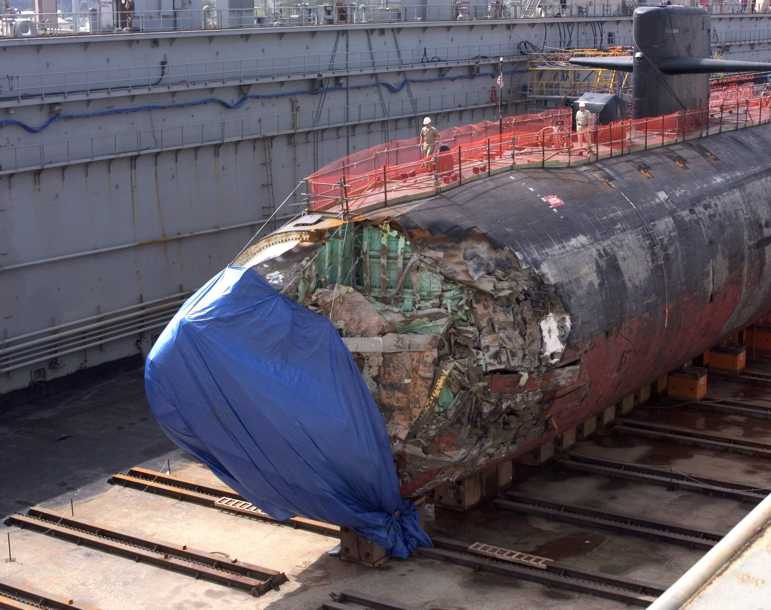
In 2005 USS San Francisco, a nuclear powered submarine, collided with a seamount about 364 nautical miles southeast of Guam. (see NYTimes)

 San Francisco dry-docked at Guam on January 27,2005
source : navsource.org

The submarine was travelling at maximum speed at a depth of 160m.
The seamount that she struck did not appear on the chart in use at the time of the accident.
Other charts available showed an area of ‘discoloured water’, an indication of the probable presence of a seamount.

 South of Guam with the Marine GeoGarage (NGA chart)

Subsequent investigation determined that information regarding the seamount should have been transferred to the charts in use, particularly given the relatively uncharted nature of the ocean area that was being transited. (source : navy.mil)

Discussion 


Figure 3 The progressive increase in the size of vessels.
The dimensions of those now at sea and on order,
reflect the shipping industry’s response to changing operational and trading patterns.


Despite a steady increase in the length of cruise ships the draught of the current vessels in service has not increased proportionately and averages 8.4m.
However, these ships are venturing into increasingly remote and poorly charted areas. Itineraries that seek to provide optimum passenger experience are potentially hazardous.
Many of the smaller vessels (l.o.a. <100m) that offer adventure cruises are fitted with forward looking sonar and can deploy portable echo sounders in their tenders.
The report of an investigation into the incident in the Canadian Artic highlights the necessity for such provision.
The significant draughts in Figure 3 are those of the large cargo vessels.
New Panamax vessels transiting the Caribbean may not be able to do so with the same confidence as their predecessors.
Elsewhere ULCC and large bulk carriers are vulnerable to an encounter with an uncharted seamount rising close to the surface.
In the deep areas of the ocean, most mariners consider that there is little chance of a vessel running aground on such a feature.
Unfortunately, this is a misconception.

 Vema seamount with the Marine GeoGarage (NGA chart)

Examples of navigationally significant seamounts include Vema Seamount (with a charted depth of 11 metres - about 1,000km west-north-west of Cape Town)

Walter shoals with the Marine GeoGarage (NGA chart)

and Walters Shoal Seamount (with a charted depth of 15 metres - about 400 nautical miles south of Madagascar).
 
These seamounts rise up from ocean depths of about 4,000 and 2,000 metres respectively.
(see AWI last seamounts discoveries, June 2014)


Conclusions 


 Australia has the third largest ocean territory in the world, but we've only mapped 12 per cent of it. The RV Investigator is using state of the art equipment and design to map the sea floor.

Many locations being accessed by cruise ships and deeper draught cargo vessels are unlikely to be surveyed to full modern standards in the foreseeable future.
Navigators of these vessels therefore need to ensure that they fully appreciate the limitations of available hydrographic data and act accordingly.
More owners should perhaps consider installing forward looking sonars for vessels operating in Polar Regions and away from recognised routes elsewhere.
Such action might well have saved World Discoverer.
It should also have prevented the damage to Noble Hawk, which incurred significant salvage and repair costs as well as the associated loss of revenue”.

Links :

Thursday, September 11, 2014

NZ Linz update in the Marine GeoGarage

Coverage NZ Linz Marine GeoGarage layer

As our public viewer is not yet available
(currently under construction, upgrading to Google Maps API v3 as v2 is officially no more supported),
this info is primarily intended to
our iPhone/iPad universal mobile application users
(Marine NZ on the App Store) 
and our B2B customers which use our nautical charts layers
in their own webmapping applications through our GeoGarage API.  


6 charts has been updated in the Marine GeoGarage
(Linz August update published 5 September 2014 (Updated to NTM Edition 17)

  • NZ463 Approaches to Wellington
  • NZ512 Cape Karikari to Cape Brett
  • NZ615 Marlborough Sounds
  • NZ5114 Doubtless Bay and Whangaroa Harbour
  • NZ6153 Queen Charlotte Sound
  • NZ6154 Tory Channel Entrance and Picton Harbour
Today NZ Linz charts (183 charts / 323 including sub-charts) are displayed in the Marine GeoGarage.

Note :  LINZ produces official nautical charts to aid safe navigation in New Zealand waters and certain areas of Antarctica and the South-West Pacific.


Using charts safely involves keeping them up-to-date using Notices to Mariners
Reporting a Hazard to Navigation - H Note :
Mariners are requested to advise the New Zealand Hydrographic Authority at LINZ of the discovery of new or suspected dangers to navigation, or shortcomings in charts or publications.

Ernest Hemingway's Cuba logs could be source for deep-sea fish data

Cojimar is a small fishing village east of Havana, forming a ward (consejo popular) part of the Habana del Este municipality.
It was an inspiration for Ernest Hemingway's The Old Man and the Sea.
(GeoCuba nautical chart with the Marine GeoGarage
Marina Hemingway in the left bottom corner))

From Sydney Morning Herald by Michael Weissenstein

A dozen tiny, ageing fishing boats bobbed in the wake of the massive, gleaming white sport-fishing yacht taking Ernest Hemingway's grandsons to the village that inspired the Nobel laureate's greatest work.
Fishermen waved to the Hemingways and hundreds waited on shore Monday to greet the descendants of a man who fished from Cojimar for decades, hauling in marlin, sharks and tuna from the warm waters off the Cuban coast.
"He was a fisherman," grandson Patrick Hemingway said, looking at the men gathered to greet him. "He considered them his brothers."

John Hemingway (left) and Patrick Hemingway (right), grandsons of the US author Ernest Hemingway, pay tribute to their grandfather at his statue in Cojimar village, Havana.
Photo: Reuters

Along with a team of US researchers, Hemingway and his brother John are on a five-day mission to leverage their famous name to encourage closer ties fbetween the United States and Cuba and, hopefully, open the way for scientists to gain access to the writer's fishing logs, a long-concealed and potentially valuable source of knowledge about the area's massive predatory game fish.

Researchers gathered little information about the health of deep-sea fish populations in the years before industrial fishing devastated populations of tuna and other highly desired big species in the second half of the last century.
That leaves sport fishermen's records as some of the only resources for marine scientists seeking a benchmark to measure population declines.


Ernest Hemingway lived in Cuba from 1939 to 1960 in a villa on lush, orchard-filled grounds in the village of San Francisco de Paula on the south-east edge of Havana.
From Cojimar, he often launched his boat, the Pilar, with first mate Gregorio Fuentes, who helped inspire the ageing fisherman who battles a giant marlin in the Pulitzer-winning Old Man and the Sea.
One of the earliest and most prolific sport fishermen in the Florida Straits, Hemingway may inadvertently have created an unparalleled scientific resource as he prowled some of the world's richest fishing grounds.
Hemingway assembled thousands of books, photographs and journals, many of which deteriorated over decades of exposure to Cuba's baking heat and high humidity, and the longstanding neglect of the estate known as Finca Vigia.
The logs are now kept by Cuba's National Cultural Heritage Council which, in order to protect the fragile documents, only allows conservators to handle them.

Hemingway proudly displays a marlin trophy in Havana Harbour (July, 1934)

Fishing logs typically contain details of the numbers of fish caught, the location of the catch and weight of the fish.
Hemingway's obsessive record-keeping, combined with the thousands of hours he spent on the water, have researchers hoping his logs could provide essential details about deep-sea fish populations over the last 75 years in the Straits.

"Hemingway was there in Cuba for 20 years. If he did keep log books for that long, having 20 years - even if it is only for a single vessel - would be very valuable," said Dr David Die a US-based fishery scientist.
"It would be a record of relative changes in the size and the abundance of fish over a period where we do not have any other records. It's exactly the type of information that we use nowadays when we assess populations of fish in the ocean."

The great white shark caught off Cojimar in 1945 which is allegedly 6.4 m (21 ft) long and weighed an estimated 3,175 kg (7,000 lb).

The US-based Finca Vigia foundation is working with the Cuban council to preserve the house and Hemingway's many documents.
Mary Jo Adams, executive director of the Boston-based foundation, said she has seen some pages of Hemingway's fishing logs, which list everything from what Hemingway and his guests ate for lunch on a certain day to how many fish they caught and the timing of the tides.

The foundation is helping Cuban curators preserve and digitise thousands of the most significant documents in the Finca Vigia.
Ms Adams said she believes many of the fishing logs may be bound and at less risk of deterioration since they have not yet been studied closely.

 Photo of Hemingway and Elicio Arguelles posing alongside a giant marlin, 
signed and inscribed in fountain pen :
“To J. C. De Clairmont from his and Wheerler’s friend, Ernest Hemingway.
This fish caught by Elicio Arguelles, Cuban sportsman, Old Man and the Sea Expedition, Cabo Blanco, northern coast of Peru, May 1956.”

Cuba's National Cultural Heritage Council declined an Associated Press request to see the logs ahead of the scientists' trip, saying only conservators could enter the storage room where most of Hemingway's documents are kept.
Apart from the fishing logs, the scientists and game-fish experts travelling with the Hemingways have other goals: 
 They hope Cuba will agree to participate in an ocean-wide program of genetically sampling white marlin and spearfish to better track them and measure the health of the species across the Atlantic. They would like organisers of an annual Cuban fishing tournament named after Hemingway to require anglers to use circular hooks, which are less-damaging and make it easier to catch and release fish.
They also hope Cuba will allow scientists to import satellite trackers which could be attached to fish caught during the tournament in order to study their movements once they are released.
The researchers acknowledge the difficulty of winning approval to bring in such equipment, which is looked at with suspicion by Cuban authorities.

Ms Adams said, however, that Dr Die's hopes of finding scientific information in the logs may be well founded.
"He kept records of everything," she said.
"I suspect the fishing logs would be just as detailed."
Dr Die acknowledged it remains far from clear whether he'll gain access to the logs, although he expects to know more after meeting with Cuban scientists and cultural officials later this week.
"Whether they even allow us to touch them, it depends on the curators," he said.
"It's an open question."

Links :

Wednesday, September 10, 2014

Canada finds British vessel that vanished on doomed North-West Passage expedition in 1840s

Explorers in Canada have found the wreck of one of two British ships lost in 1845 to the country's Northwest Passage that vanished with 128 crew during Sir John Franklin’s “lost expedition” to find route through Arctic ice
(see original video)

From The Telegraph by Philip Sherwell

One of the most enduring and tragic mysteries of British maritime history came a crucial step closer to being solved on Tuesday when Canada announced the discovery of a Royal Navy vessel that disappeared in the Arctic nearly 170 years ago.
The HMS Erebus and HMS Terror were last seen in 1845 under the command of Sir John Franklin on a doomed Admiralty expedition to find the legendary Northwest Passage of ice-filled waters linking the Atlantic and Pacific.
Their disappearance launched one of the largest rescue operations in history, lasting from 1848 to 1859.
The vessels were never found, but the searches did result in the discovery of the fabled passage through the Arctic archipelago.

 A painting of the HMS Erebus trapped in ice (PA)

Inuit hunters told a Scottish explorer in 1854 that the ships had become icebound.
They said the crew had tried to escape on foot but were defeated by the cold and some even resorted to cannibalism to try to survive – a report that caused outrage when it reached London.

Canadian Geographic

 CHS nautical chart with the Marine GeoGarage


Stephen Harper, the prime minister, said that the wreckage of one of the missing vessels has now been located using a recently deployed, remotely operated underwater vehicle.
He said that although it was unclear which ship had been found, the sonar images recorded on Sunday contained enough information to confirm that they showed one of the pair.
The sonar images indicate that the vessel is remarkably well-preserved.
Ryan Harris, an underwater archeologist who is one of the Parks Canada search team leaders,said that the image projected at a press conference showed the deck structures were intact, including the main mast, which was sheared off by the ice when the ship sank.
He expected the ship’s contents to be in similarly good condition.

 Sonar picture (Parks Canada)

Canada launched a fresh search operation using divers and archaeologists in 2008 to find the ships, which were believed to have become trapped in ice off King William Island in the Victoria Strait in the Arctic territory of Nunavut before being carried for hundreds of miles.
Conflicting reports handed down through local tribal communities about where the vessels sank meant that the new generation of explorers were targeting a huge and inaccessible search area.

 Parks Canada's Ryan Harris, left, briefs Canadian Prime Minister Stephen Harper on efforts to find the Franklin Expedition aboard the HMCS Kingston west of Pond Inlet on Eclipse Sound in Nunavut, Canada on Aug. 24. (see PM info)

I am delighted to announce that this year's Victoria Strait expedition has solved one of Canada's greatest mysteries, with the discovery of one of the two ships belonging to the Franklin Expedition," Mr Harper said.
"Finding the first vessel will no doubt provide the momentum - or wind in our sails - necessary to locate its sister ship and find out even more about what happened to the Franklin Expedition's crew."
The disappearance and grisly fate of the 128 hand-picked crew had long fascinated Canadians.
"This is truly a historic moment for Canada," Mr Harper continued during a visit to
Parks Canada's laboratories in Ottawa after the recent discovery of expedition relics on an island in Nunavut.
"This has been a great Canadian story and mystery and the subject of scientists, historians, writers and singers so I think we really have an important day in mapping the history of our country."
On Monday, the Nunavut government announced that a team of archaeologists found an iron fitting and wooden artifact from a Royal Navy ship on an island in the southern search area.
Other traces of the expedition have been found over the years.
The frozen remains of three crewmen were recovered in the 1980s, including the perfectly preserved body of John Torrington, a 20-year-old petty officer , in an ice-filled coffin.
European explorers had been frustrated in their efforts to find the passage as a shorter route to Asia since John Cabot died on an expedition voyage in 1497.
Roald Amundsen of Norway finally completed the first trip in 1906.

Erebus and Terror Leaving for discovery of North-West Passage (Alamy)

Sir John was undertaking his fourth Arctic expedition when his team vanished.
His two vessels were equipped with the latest in nautical technology for the arduous conditions, a water distillation system and three years' worth of preserved and tinned food supplies.
In 1847, his wife urged the Admiralty to send a search party, but the British government delayed that mission for another year.
When the Admiralty finally launched its search, it also offered a £20,000 reward – a huge sum in those days that attracted so many search ships that eventually more vessels and men were lost looking for the expedition than had set out under Sir John.
Mr Harper’s government announced the new search in 2008 as Canada sought to establish sovereignty over the disputed waters of the Northwest Passage where melting polar ice has finally opened the shipping route that Sir John’s doomed expedition was seeking.

Links :

Tuesday, September 9, 2014

First of its kind map reveals extent of ocean plastic

A plastic bag floats in the water off the coast of Pulau Bunaken, Indonesia.
Photo : Paul Kenedy, Getty

From National GeoGraphic

When marine ecologist Andres Cozar Cabañas and a team of researchers completed the first ever map of ocean trash, something didn't quite add up.

Their work, published this month in the Proceedings of the National Academy of Sciences, did find millions of pieces of plastic debris floating in five large subtropical gyres in the world's oceans.
But plastic production has quadrupled since the 1980s, and wind, waves, and sun break all that plastic into tiny bits the size of rice grains.
So there should have been a lot more plastic floating on the surface than the scientists found.

"Our observations show that large loads of plastic fragments, with sizes from microns to some millimeters, are unaccounted for in the surface loads," says Cozar, who teaches at the University of Cadiz in Spain, by e-mail.
"But we don't know what this plastic is doing. The plastic is somewhere—in the ocean life, in the depths, or broken down into fine particles undetectable by nets."
What effect those plastic fragments will have on the deep ocean—the largest and least explored ecosystem on Earth—is anyone's guess.
"Sadly," Cozar says, "the accumulation of plastic in the deep ocean would be modifying this enigmatic ecosystem before we can really know it."
But where exactly is the unaccounted-for plastic?
In what amounts?
And how did it get there?
"We must learn more about the pathway and ultimate fate of the 'missing' plastic," Cozar says.

The Great Pacific Garbage Patch is a huge mass of rubbish, or trash vortex,
held in place in the north-east of the Pacific Ocean by swirling underwater currents.
This build-up of marine debris is a danger to many marine mammals, birds and underwater ecosystems as a whole.

Plastic, Plastic Everywhere

One reason so many questions remain unanswered is that the science of marine debris is so young.
Plastic was invented in the mid-1800s and has been mass produced since the end of World War II.
In contrast, ocean garbage has been studied for slightly more than a decade.

"This is new mainly because people always thought that the solution to pollution was dilution, meaning that we could turn our head, and once it is washed away—out of sight, out of mind," says Douglas Woodring, co-founder of the Ocean Recovery Alliance, a Hong Kong-based charitable group working to reduce the flow of plastic into the oceans.

The North Pacific Garbage Patch, a loose collection of drifting debris that accumulates in the northern Pacific, first drew notice when it was  discovered in 1997 by adventurer Charles Moore as he sailed back to California after competing in a yachting competition.

A turning point came in 2004, when Richard Thompson, a British marine biologist at Plymouth University, concluded that most marine debris was plastic.

Research on marine debris is also complicated by the need to include a multidiscipline group of experts, ranging from oceanographers to solid-waste-management engineers.
"We are at the very early stages of understanding the accounting," says Kara Lavender Law, an oceanographer at the Sea Education Association, based in Cape Cod, Massachusetts. 
"If we think ten or a hundred times more plastic is entering the ocean than we can account for, then where is it? We still haven't answered that question.
"And if we don't know where it is or how it is impacting organisms," she adds, "we can't tell the person on the street how big the problem is."
Law, along with Thompson, is one of 22 scientists researching marine debris for the National Center for Ecological Analysis and Synthesis at the University of California, Santa Barbara.
The group is grappling with some of these questions and plans to publish a series of papers later this year.
One of the most significant contributions made by Cozar's team, says Law, was data collected in the Southern Hemisphere: "I can't tell you how rare that is."

 Great Pacific Garbage Patch

New maps document floating plastic trash
 
Tens of thousands of tons of plastic garbage float on the surface waters in the world's oceans, according to researchers who mapped giant accumulation zones of trash in all five subtropical ocean gyres.
Ocean currents act as "conveyor belts," researchers say, carrying debris into massive convergence zones that are estimated to contain millions of plastic items per square kilometer in their inner cores.


 G Staff, Jamie Hawk
Source : Andrés Cozar, University of Cadiz, Spain

One Answer

Cozar's team was part of the Malaspina expedition of 2010, a nine-month research project led by the Spanish National Research Council to study the effects of global warming on the oceans and the biodiversity of the deep ocean ecosystem.
Originally Cozar was assigned to study small fauna living on the ocean surface.
But when tiny plastic fragments kept turning up in water samples collected by the expedition scientists, Cozar was reassigned to assess the level of plastic pollution.
The two-ship expedition spent nine months circumnavigating the world. But Cozar also used data gathered by four other ships that had traveled to the polar regions, the South Pacific, and the North Atlantic to complete the map.

The team analyzed 3,070 water samples.
"One of the most striking observations was the conspicuous presence of plastic in the surface samples, even thousands of kilometers from the continents," he says.
"The plastic garbage patch in the South Atlantic Gyre was one of the most striking."

Cozar says that one answer to the missing-plastic mystery is that some of the tiniest bits of plastic are being consumed by small fish, which live in the murky mesopelagic zone, 600 feet to 3,300 feet (180 to 1,000 meters) below the surface.
Little is known about these mesopelagic fish, Cozar says, other than that they're abundant.
They hide in the darkness of the ocean to avoid predators and swim to the surface at night to feed.
"We found plastics in the stomachs of the fishes collected during Malaspina's circumnavigation," he says. "We are working on this now."
One of the most common mesopelagic fish is the lantern fish, which lives in the central ocean gyres and is the main link in the tropical zone between plankton and marine vertebrates.
Because lantern fish serve as a primary food source for commercially harvested fish, including tuna and swordfish, any plastic they eat ends up in the food chain.
"There are signs enough to suggest that plankton-eaters, the small fishes, are important conduits for plastic pollution and associated contaminants," Cozar says.
"If this assumption is confirmed, the impacts of a man-sustained plastic pollution could extend over the ocean predators on a large scale."

Links :
  • AIP : How well-connected is the surface of the global ocean?
  • NT Times : Choking the Oceans With Plastic (by Charles J. Moore)
  • WhyFiles : Oceans’ true boundaries explain the source of ocean water — and “garbage patches”
  • NBCnews : Math might help nail Oceans' plastic 'Garbage Patch' polluters
  • FastCoexist : James Dyson is designing a giant vacuum-on-a-boat to clean ocean trash
  • GeoGarage blog : Ocean garbage patch is mysteriously disappearing

Monday, September 8, 2014

Live interactive 3D map lets you watch rain, clouds and even hurricanes across the globe


From DailyMail  by Jonathan O'Callaghan

  • an interactive map from Europe's MeteoGroup lets you watch weather unfold around the world
  • by selecting different icons weather of varying types can be watched live in different countries
  • for example users can see the global cloud cover and also where it is raining at the moment
  • the interactive map even tracks the path of tropical storms and shows where wind is moving on Earth
  • data is pulled live from a forecast model by the European Centre for Medium-Range Weather Forecasts
Ever wanted to see what's going on with the weather in the world at this very second?
Now you can thanks to an interactive map that lets you see temperature, rainfall, winds and more in countries across the globe.

Called MeteoEarth you can navigate around the 3D globe below using your mouse, while selecting the icons on the right hand side will also reveal different types of weather.
MeteoEarth.com was launched by MeteoGroup, headquartered in London, one of Europe’s leading private weather companies.
The technology which powers MeteoEarth.com has been adapted from a professional broadcasting tool used by TV presenters around the world
Impressive 3D graphics compliment the high-end gaming technology used to fully engage the user with exploring the world’s weather.

For people who are simply interested in gaining a general overview of the world’s weather conditions, they can choose from a selection of weather layers; ranging from precipitation and cloud cover, to wind direction and temperature.
They can zoom in to focus on different areas of the world, zoom out to get a global overview, or even rotate the globe using the mouse.
For the more avid weather enthusiasts, there is the option to observe tropical storms by simply clicking a button to be guided towards an area on the globe where a tropical storm is occurring, with a line showing its path.
Once here, there are details of the storm’s name, wind, gust and overall speed.
Different layers of weather information can be built up to visualize the storm in its entirety.


An interactive map from Europe's MeteoGroup lets you watch the weather unfold around the world. By selecting different icons weather of varying types can be watched live in different countries.
For example users can see the global cloud cover or also where it is raining at the moment.
The interactive map even tracks the path of tropical storms (shown in Central America ) and shows where wind is moving on Earth

The interactive map will also show isobars (seen here above the UK), which reveal high and low-pressure systems (pictured).
In order to make the air pressure comparable, no matter what height you’re at, the air pressure is converted to the mean sea level.
As a comparison value, the barometric (atmospheric) pressure is shown in white, high pressure areas are in red and low air pressure is in blue

In addition a built-in screenshot feature provides an easy way to take particular weather images of a certain area, capturing still images of weather situations.
The frame of the map can be altered to include close-up sections of the map or zoomed out to get a more global overview.
The data on MeteoEarth.com comes from a forecast model by the European Centre for Medium-Range Weather Forecasts.
This is then refined by MeteoGroup using their own algorithms, and finally visualised on the website in the interactive map..
The data on MeteoEarth.com is updated twice per day.
It comes from the forecast model each day at 0:00UTC and 12:00UTC and the data is updated at 6:00UTC and 18:00UTC.

This is all an automated process with no human interaction, although MeteoGroup tells MailOnline their in-house developers are currently working on improving this process to offer an even more ‘live’ representation.
'This website will help to educate users with no prior meteorological experience about the weather,' said David Kaiser, Head of Consumer at MeteoGroup.
'The breathtaking graphics combined with the wealth of information about each weather feature provides an engaging demonstration of the world’s current weather and is sure to provide hours of entertainment to anybody viewing it.'

Data is pulled live from a forecast model by the European Centre for Medium-Range Weather Forecasts.
'This website will help to educate users with no prior meteorological experience about the weather,' said David Kaiser, Head of Consumer at MeteoGroup.
'The breathtaking graphics combined with the wealth of information about each weather feature provides an engaging demonstration of the world’s current weather and is sure to provide hours of entertainment to anybody viewing it'

Links :

Sunday, September 7, 2014

Creating within : an incredible journey inside waves

Breathtaking slow motion waves

An award winning documentary that follows two lifelong friends, on a surfing pilgrimage to remote parts of the Australian coastline to film epic waves in memory of their other friend who took his life.
It captures their journey of filming in the elements, as the film Within is brought to life.
Filmmaker Darius reflects on how Billy's death sparked the beginning of his inward journey, shifting his perspective about what matters in life and expanding his connection to the ocean, into new forms of visual expression.


An impressionistic exploration of the ocean, Within creates the space to linger, in vivid detail, dwelling on the ocean in movement, flowing through the majestic folds of nature.