Thursday, May 31, 2012

France SHOM layer update in the Marine GeoGarage

291 charts from SHOM have been added in the Marine GeoGarage :

  • 278    Environs de Raguse (Dubrovnik) Gravosa (Gruz), Raguse (Dubrovnik), Breno (Zulski)  
  • 280    Golfe de Cattaro   
  • 1292    Carte du Golfe de Smyrne et de ses abords   
  • 1442    Du Cap Saint-Vincent au Cap Saint-André   
  • 1456    Carte de la partie septentrionale de l'Archipel (Grèce)   
  • 1461    Ile Capraja   
  • 1490    Entrée des Dardanelles, golfe d' Adramyti, îles de Mitylène, Tenedos, Lemnos et Strati   
  • 1619    Mouillages de Tarifa   
  • 1700    Baie de Tétouan   
  • 1701    Tanger et ses atterrages   
  • 1946    Nouvelle-Calédonie (3ème feuille) côte Ouest   
  • 2040    Du Grand Banc des Mosquitos à la Passe Windward   
  • 2089    Carte des Canaux d'Egripo, de Talante et d'Oréos, et de l'île de Négrepont   
  • 2114    Mer des Caraïbes Bassin Nord-Ouest  
  • 2122    De l'île d'Elbe à Naples   
  • 2463    Madère, Porto Santo, îles Désertes   
  • 2662    Canal d'Otrante   
  • 2799    Nouvelle-Calédonie (4ème feuille) Partie Nord  
  • 3023    De Djidjelli à Collo   
  • 3024    Du Cap Toukoush au Cap Rose   
  • 3029    Du Cap Sigli à Djidjelli   
  • 3030    D'Alger à Cherchell   
  • 3036    De Dellys au Cap Sigli   
  • 3043    D'Alger à Dellys   
  • 3061    Du Cap Bougaroni au Cap Axin   
  • 3202    De Cherchell à Ténès   
  • 3234    De la Pointe Kef el Assfer au Cap Ténès   
  • 3357    De la Pte Banda à la Riv. Coanza   
  • 3405    D'Alger à la frontière de Tunisie   
  • 3424    Du Cap Rose au Cap Nègre   
  • 3453    De la Pointe Rossello à la Pointe Scalambri   
  • 3462    Baie de Ba (Baie Le Bris)   
  • 3470    De Mazzara à Agrigento, île Pantellaria   
  • 3475    Baie de Ugué   
  • 3519    Delta du Tonkin   
  • 3534    Port de Trieste et Baie San Bartolomeo   
  • 3675    Carte générale de l'île de Sardaigne   
  • 3678    Côte de l'Algérie (1ère feuille), d'Alger à la frontière du Maroc   
  • 3684    De Trapani à Marsala et îles adjacentes   
  • 3731    Du Cap Cefalu à Mazzara   
  • 3757    De Taormina au Cap Cefalu (Ilipari Détroit de Messine)   
  • 3790    Sicile, du Cap Scalambri à l'entrée Sud du Détroit de Messine   
  • 3972    De l'île Paaba à l'île Pott   
  • 3975    Mer Adriatique Partie Nord  
  • 3976    Mer Adriatique Partie Sud  
  • 3978    Abords et entrée des Dardanelles   
  • 3992    D'Ancône à Ortona   
  • 4004    D'Ortona à Barletta   
  • 4005    De Barletta à Brindisi   
  • 4030    Entrée du Golfe de Tarente   
  • 4044    Golfe de Tarente   
  • 4071    De Crotone au Cap Spartivento   
  • 4113    Baie de Vohemar   
  • 4129    Du Cap Serrat au Cap Blanc   
  • 4174    De la Baie d'Antongil à Manakara   
  • 4177    Du Cap Saint-Vincent à Manakara   
  • 4191    De Ras-al-Fortas à Kelibia   
  • 4198    Du Ras Enghela au Cap Farina Baie et lac de Bizerte  
  • 4208    De Ksar Menara à Sousse   
  • 4212    Port Conte et rade d'Alghero   
  • 4219    Du Cap Roux au Cap Serrat (Tabarca et Cap Négro)   
  • 4221    De Kelibia à Ras Mamour   
  • 4222    Du Cap Kamart au Ras-al-Fortas (Golfe de Tunis)   
  • 4225    De Kurba à la Sebkha Djiriba (Golfe d'Hammamet)   
  • 4226    Du Ras Marsa au Ras Dimas (Golfe de Sousse et de Monastir)   
  • 4227    Du Ras Dimas au Ras Kapudia   
  • 4228    De Sfax à Mahares   
  • 4229    Golfe d'Asinara   
  • 4235    Du Ras Kapudia au Ras Ungha (Iles et bancs Kerkenah)   
  • 4236    Du Ras Kapudia à Sidi Makluf (partie Nord du canal de Kerkenah)   
  • 4237    De Sidi Makluf à Sfax (Iles Kerkenah)   
  • 4239    De Maharès à la Skhirra (Golfe de Gabès)   
  • 4240    De la Skhirra à Gabès (Golfe de Gabès)   
  • 4241    Gabès (ancienne Tacape)   
  • 4242    De Gabès au Bordj Djilidj (Golfe de Gabès)   
  • 4244    Du Bordj Djilidj à Sidi Garus (partie Nord de l'île de Djerba)   
  • 4250    Du Cap Farina au Cap Carthage (Delta de Medjerda)   
  • 4256    Bouches de Cattaro (Kotor) et côtes environnantes   
  • 4314    De Bône à Tunis   
  • 4315    De Tunis à Sfax   
  • 4451    Du Cap Voailava au Cap Saint-Sébastien   
  • 4462    Du Cap Saint-Sébastien à la rivière Sahinana   
  • 4646    Du Cap Palinuro au Cap Vaticano   
  • 4715    Rade de Tuléar Baie de Saint-Augustin  
  • 4798    Golfe de Volo et ses abords   
  • 4845    Du Cap Mesurado à la Pointe Baffu   
  • 4850    Du Cap Sainte-Anne au Cap Mesurado   
  • 4852    De la rivière Antsena au Cap Tanjo (Baie de Bombetoka)   
  • 4970    Lac de Bizerte   
  • 5023    Iles au Sud de la Sicile   
  • 5128    Partie Sud de Nossi-Bé   
  • 5220    Ports de la côte Est d'Italie   
  • 5281    Port de Bizerte et goulet du lac   
  • 5346    Baie du Courrier et ses abords   
  • 5365    Du Guadalquivir au Cap Trafalgar   
  • 5414    Baie d'Halong   
  • 5417    Océan Atlantique Nord et mers boréales   
  • 5441    Plans à la côte Nord-Ouest d'Espagne Baie de Corcubion  
  • 5461    Iles Barren Atterrages de Maintirano  
  • 5462    Du Cap de Fedala au Cap de Mazagan   
  • 5480    Baie du Lévrier   
  • 5516    De la rivière Tsiribihina au Cap Kimby
  • 5563    Baie de Nhatrang   
  • 5571    Cambodge et Cochinchine Mékong  
  • 5617    Port d'Alger   
  • 5636    Du Nez de Jobourg à la Pointe de Nacqueville   
  • 5638    Baie d'Alger   
  • 5640    Port de Dellys   
  • 5641    Port de Bejaia (Bougie)   
  • 5669    Port d'Annaba (Bône)   
  • 5670    Abords de Bône   
  • 5678    Port d'Arzew   
  • 5697    Rade de Casablanca   
  • 5698    Ile de La Galite   
  • 5700    Port du Pirée et Baie de Phalère Port Héraclée  
  • 5749    Ports et mouillages aux îles de Kerguelen   
  • 5750    Ports et mouillages aux îles Kerguelen   
  • 5752    Rivière Saloum De Foundiougne à Kaolack Rivières Sine et Silif 
  • 5762    Abords d'Oran   
  • 5763    Ports d'Oran et de Mers-el-Kébir   
  • 5787    Abords de Skikda   
  • 5791    De Bizerte aux îles Cani   
  • 5793    Abords de Pola   
  • 5796    Du Cap Nord au Cap Tchéliouskine   
  • 5798    Yougoslavie   
  • 5820    Groupe Santorin   
  • 5834    Iles du Cap Vert   
  • 5851    Abords de Saint-Louis Mouillage de Saint-Louis  
  • 5864    Ports et mouillages sur la côte Nord du Maroc   
  • 5873    Port de Nemours   
  • 5876    Ile Rachgoun Embouchure de la Tafna  
  • 5878    Ilots dans l'archipel des Tuamotu   
  • 5915    Accès de Nouadhibou   
  • 5923    Abords d'Alexandrie   
  • 5929    Abords d'Arzew   
  • 5931    Du Rio Grande aux îles de Los   
  • 5940    De la Tafna au Cap Sigale   
  • 5941    Des îles de Los à l'île Sherbro   
  • 5948    D'Arzew au Cap Figalo   
  • 5951    Du Cap Ferrat à la Pointe Kef el Asfer   
  • 5955    Rade et port d'Agadir   
  • 5957    Du rio Cacheu aux îles de Los   
  • 5962    De Tuléar au Cap Sainte-Marie   
  • 5976    Du Cap Andavaka à Sainte-Luce   
  • 5978    Mer du Corail Iles et récifs épars  
  • 5980    Bras de la Fonderie   
  • 5983    Archipel des Comores   
  • 5993    Baie de Cansado Nouadhibou (Port-Étienne)  
  • 6011    Des îles Zafarines à la Tafna   
  • 6014    De la terre Peary au Scoresby Sound et de Trondheim au Cap Nord   
  • 6015    Des passages du Nord-Ouest à la Mer du Groenland   
  • 6062    Ports de la Goulette et de Tunis   
  • 6063    Rade de Tuléar   
  • 6077    Baie de Bombétoke Rade de Majunga  
  • 6078    Baie de Bombétoke Mouillages  
  • 6081    Mouillages de Fénérive et de Foulpointe   
  • 6083    Du Cap Juby au Cap Blanc   
  • 6103    Rade de Safi   
  • 6111    Abords de Casablanca   
  • 6113    Du Cap Blanc au Cap Vert   
  • 6119    Rade de Mazagan   
  • 6120    Abords de Mazagan   
  • 6135    Cours de la Casamance Du banc de Ouangaran à la Pointe Samis  
  • 6137    Cours de la Casamance De l'embouchure à Ziguinchor  
  • 6143    De Temara au Cap de Fédala   
  • 6147    Cours du Saloum De l'embouchure à Foundiougne  
  • 6148    Embouchure du Rio Nunez   
  • 6150    Mouillage et Passes de Tamatave   
  • 6154    De Nosy Fanala à l'île Sainte-Marie Baie d'Antongil  
  • 6155    Abords de l'île Sainte-Marie   
  • 6156    De l'île Sainte-Marie à Tamatave   
  • 6169    Abords de Safi   
  • 6170    Du Cap de Mazagan au Cap Cantin   
  • 6174    De Joal à Bathurst   
  • 6176    Maupihaa (Maupélia)   
  • 6178    Du Cap Ghir à Agadir   
  • 6183    Baie de Corisco Rivières Mondah et Muny  
  • 6204    Rade d'Essaouira (Mogador)   
  • 6206    Du Cap Hadid au Cap Sim   
  • 6214    Grande Canarie   
  • 6226    Du Cap Cantin au Cap Sim   
  • 6227    Du Cap Sim à l'Oued Massa   
  • 6228    Accès au Rio Nunez   
  • 6237    Ile Mayotte   
  • 6238    Iles Anjouan et Mohéli   
  • 6239    Grande Comore   
  • 6269    De Meregh à Merca   
  • 6270    De Merca à Chisimaio   
  • 6286    Mouillage de Tabou   
  • 6288    Rio Nunez Abords de Port Kamsar  
  • 6290    Abords de Sihanoukville (Kompong Som)   
  • 6293    Port de Kinsale Port Oyster  
  • 6297    Embouchure de la Casamance   
  • 6306    Mouillages de Mananara et d'Antanambe   
  • 6315    Canal de Sainte-Marie, partie Sud   
  • 6318    Abords Nord de Tamatave   
  • 6319    Abords Sud de Tamatave   
  • 6321    Grand-Bereby   
  • 6325    Baie de la Skhirra ou des Sur-Kenis   
  • 6326    Iles Seba   
  • 6341    Anse de Mazarron Ports de Aguilas et El Hornillo  
  • 6342    Cours du Guadalquivir De l'embouchure à Séville  
  • 6345    Abords Nord de Morombe   
  • 6353    Du delta de la Tsiribihina à Nosy Andriamitaroka   
  • 6369    Estuaire du Gabon   
  • 6372    Du Cap Estérias à la Pointe Ekoueta   
  • 6375    Port de Pasajes   
  • 6376    Du Cap Gracias à Dios au Cap de la Aguja   
  • 6381    Ports de la côte Nord d'Espagne   
  • 6383    Ports de la côte Nord d'Espagne   
  • 6384    Port de Civitavecchia   
  • 6421    Archipel des Tuamotu Iles Arutua, Apataki, Kaukura, Niau  
  • 6453    Fleuve Congo De l'embouchure à Quissanga  
  • 6461    Iles Gambier   
  • 6462    Iles Gambier, partie Sud   
  • 6464    Iles Mangareva, Rikitea, Totegegie   
  • 6497    Ile de la Possession, île de l'Est   
  • 6498    Iles Crozet   
  • 6517    Du Cap Guardafui à Mogadiscio   
  • 6527    Port de Tamatave   
  • 6569    Mer d'Alboran Feuille Nord  
  • 6570    Mer d'Alboran, feuille Sud   
  • 6596    De Grand-Béréby à Sassandra   
  • 6606    Canal de Sicile   
  • 6611    Entrée de la Méditerranée Côte d'Espagne de Huelva au Cap de Palos et côte d'Afrique de Mehdia au Cap Ferrat  
  • 6624    INT 104 De Lisbonne (Lisboa) à Freetown  
  • 6643    Iles et récifs du canal de Mozambique   
  • 6644    Ports et mouillages d'Angola   
  • 6666    De l'estuaire du Gabon à l'estuaire du Congo   
  • 6679    Cours de l'Odet De Bénodet à Quimper  
  • 6686    Nouvelle-Calédonie (partie Sud-Est) Iles Loyauté  
  • 6688    Iles de la Société, de Manuae à Tahiti   
  • 6689    Iles Tuamotu (partie Ouest), de Tahiti à Rangiroa et Makemo   
  • 6690    Iles Tuamotu (partie centrale) de Makemo à Tatakoto   
  • 6691    Iles Tuamotu (partie Est) de Hao à Fangataufa   
  • 6692    Des îles Tuamotu aux îles Gambier   
  • 6741    Iles Kerguelen   
  • 6771    De l'Ecosse (Scotland) à l'Islande (Island)   
  • 6878    Golfe de Suez De Râs Ghârib au port de Suez  
  • 6908    Détroits de Jubal et de Tīrān   
  • 6978    Golfe d'Aqaba   
  • 7013    Baie de Suez (Bahr al Qulzum)   
  • 7014    INT 304 Des îles Baléares à la Corse et à la Sardaigne  
  • 7020    Ports du Golfe de Gênes (Genova)   
  • 7062    Ports du Golfe de Guinée   
  • 7068    INT 1802 De la presqu'île de Quiberon aux Sables-d'Olonne  
  • 7071    Port de Mits'iwa (Massawa)   
  • 7099    Mer Rouge Partie Sud De l'archipel Sawākin aux îles Hanīsh 
  • 7111    Approches de Hodeida (al Ḩudaydah)
  • 7112    Mer Rouge - Partie centrale - De Abū el Kizân à l'archipel Sawākin
  • 7114    Ibiza et Formentera   
  • 7115    Mallorca Partie Ouest De Punta Beca à Punta Salinas 
  • 7116    Mallorca Partie Est De Punta Salinas à Cabo de Formentor 
  • 7117    Menorca Ports et mouillages de Menorca  
  • 7118    Abords de Palma De Isla Dragonera à Cabo Blanco  
  • 7119    Ports et mouillages de Mallorca et Cabrera   
  • 7165    Ile Maurice   
  • 7169    Ports de Chypre   
  • 7171    Approches des îles Saint-Paul et Amsterdam   
  • 7185    INT 1085 De Cabo Roxo à Monrovia  
  • 7188    INT 2088 De Lagos à Gamba  
  • 7204    De Marseille à l'île d'Elbe (Isola d'Elba) et aux Bouches de Bonifacio   
  • 7213    Maupiti   
  • 7245    Ports et mouillages en Mer de Marmara   
  • 7246    Polynésie française   
  • 7253    Golfe de Corinthe (Korinthiakós Kólpos) - Golfe de Pátras (Patraïkós Kólpos)
  • 7254    Golfe d'Athènes (Saronikós Kólpos)
  • 7255    INT 3606 De El Lādhiqiyeh à Soûr
  • 7256    INT 3608 De Soûr à Al Arish
  • 7260    De Apataki à Fakarava   
  • 7262    De Makemo à Marutea Nord   
  • 7263    Iles Cyclades (Kikládhes Nísoi) - Partie Ouest
  • 7264    Iles Cyclades (Kikládhes Nisoi) - Partie Est
  • 7268    Nouvelle-Calédonie Iles Loyauté  
  • 7284    De Argolikós Kólpos à Níos Póros
  • 7295    Ports et mouillages entre Cabo de la Nao et Cabo de Palos   
  • 7298    Ports et mouillages entre la frontière franco-espagnole et Tarragona   
  • 7342    De Nísos Sými à Kaş - Nísos Ródos
  • 7346    Iles du Roi Georges. Takaroa et Takapoto   
  • 7353    Ua-Pou et Ua-Huka   
  • 7368    INT 653 De l'Ile Malden aux Iles de la Société  
  • 7370    INT 655 De Mururoa à Ducie Island  
  • 7375    De la Passe de Poya à la Passe de Koné   
  • 7377    Ports du Larivot et de Cayenne   
  • 7453    Makemo   
  • 7455    Archipel des Tuamotu Passes et Mouillages  
  • 7458    Aratika   
  • 7507    Du Golfe du Lion aux Bouches de Bonifacio   
  • 7518    INT 7118 De Al Ḩudaydah à Al Mukhā
  • 7594    INT 9016 De la Pointe Ebba au Cap de la Découverte  
  • 7758    Îles Belep -Îles Pott et Art -Îles Daos du Nord

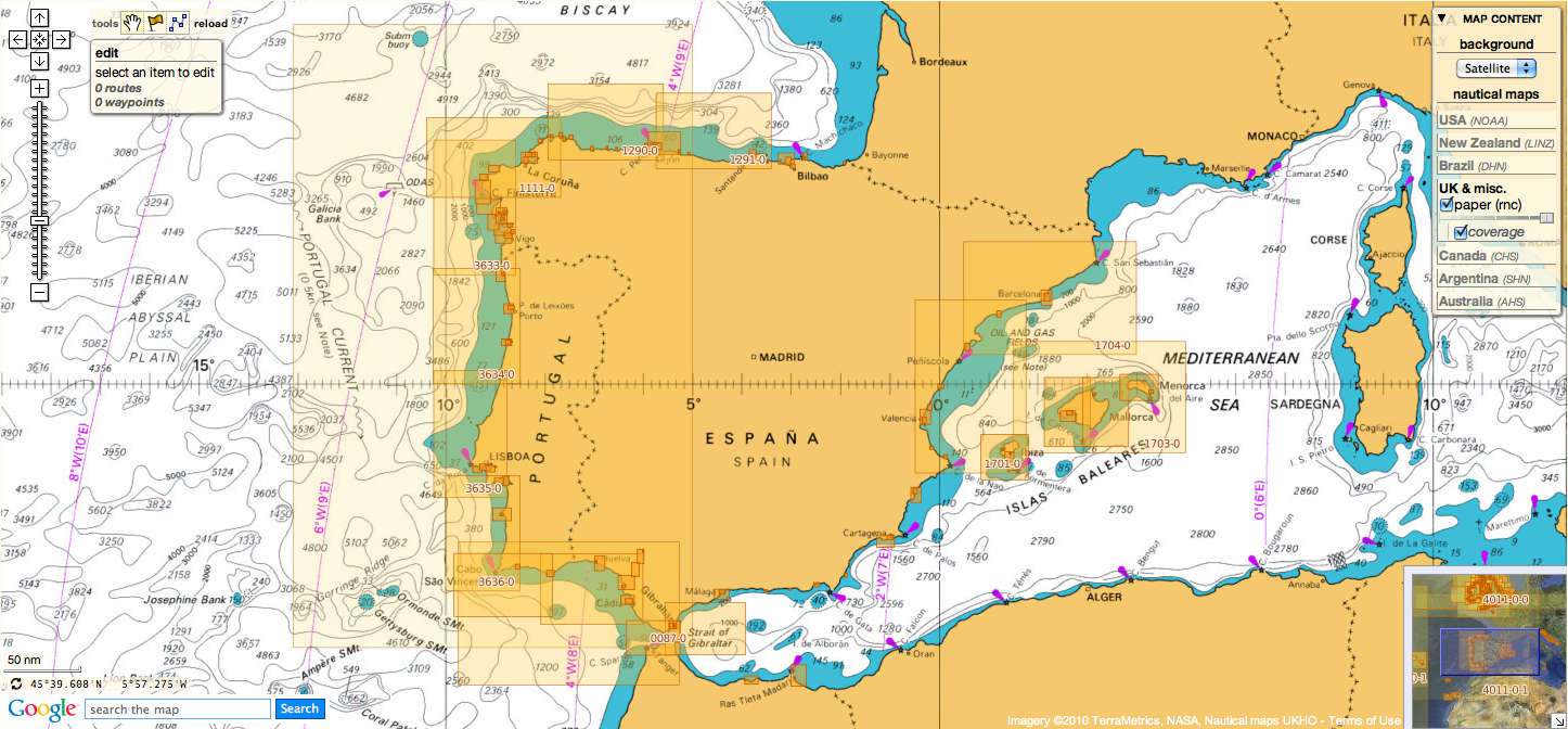
so 661 charts from SHOM are displayed in the Marine GeoGarage

CryoSat goes to sea

Gravity field over the Pacific Ocean’s Emperor Seamounts based on CryoSat, ERS and Geosat satellite altimeter measurements of ocean-surface height.
At this scale, the gravity field of the ocean reflects seafloor topography, called bathymetry.
The improved radar measurements from CryoSat will be used to improve bathymetry. The measurements will be used in the next generation of the seafloor maps in Google Earth.
Credits: Scripps Institution of Oceanography/NOAA

From ESA

CryoSat was launched in 2010 to measure sea-ice thickness in the Arctic, but data from the Earth-observing satellite have also been exploited for other studies.
High-resolution mapping of the topography of the ocean floor is now being added to the ice mission’s repertoire.

The main objective of the polar-orbiting CryoSat is to measure the thickness of polar sea ice and monitor changes in the ice sheets that blanket Greenland and Antarctica.
But the satellite’s radar altimeter is not only able to detect tiny variations in the height of the ice but it can also measure sea level.

The topography of the ocean surface mimics the rises and dips of the ocean floor due to the gravitational pull.


An Earth-orbiting radar cannot see the ocean floor, but it can measure ocean-surface height variations induced by the topography of the ocean floor.
The gravitational pull of the seafloor produces minor variations in ocean surface height.
Seafloor mapping by ships is much more accurate than radar altimeter mapping, but to date only 10% of the seafloor has been charted this way.
A complete mapping of the deep oceans using ships would take 200 ships navigating Earth, 24 hours a day, for an entire year at a cost of billions of dollars.
Mapping using satellite radars can cover a larger area in a shorter amount of time.
When interesting features are discovered in satellite measurements, they can later be surveyed in fine detail by ships.
Credits: Scripps Institution of Oceanography

Areas of greater mass, such as underwater mountains, have a stronger pull, attracting more water and producing a minor increase in ocean-surface height.

Therefore, instruments that measure sea-surface height incidentally map the ocean floor in previously uncharted areas.

There have been several recent global gravity missions, such as ESA’s GOCE satellite, that provide extraordinarily accurate measurements of gravity at the spatial resolution of hundreds of kilometres.

CryoSat determines variations in the thickness of floating sea-ice so that seasonal and interannual variations can be detected.
The satellite also surveys the surface of continental ice sheets to detect small elevation changes.
Information on precise variations in ice thickness will further our understanding of the relationship between ice and climate change.
Credits: ESA /AOES Medialab

But CryoSat’s radar altimeter can sense the gravity field at the ocean surface, so that seafloor characteristics at scales of 5–10 km are revealed.
This is the first altimeter in 15 years to map the global marine gravity field at such a high spatial resolution.

Recent studies at the Scripps Institution of Oceanography in San Diego, USA, found that the range precision of CryoSat is at least 1.4 times better than the US's Geosat or ESA's ERS-1.

They estimate that this improved range precision combined with three or more years of ocean mapping will result in global seafloor topography – bathymetry – that is 2–4 times more accurate than measurements currently available.

“We know more about the surfaces of Venus and Mars than we do about the bathymetry of deep oceans,” said David Sandwell from the Scripps Institution of Oceanography in the US.
“This new mapping from CryoSat will revolutionise our understanding of ocean floor tectonics and reveal, perhaps, 10 000 previously uncharted undersea volcanoes.”

Most satellite radar altimeters such as the one on the joint CNES/NASA/Eumetsat/NOAA Jason-2 follow repeated ground-tracks every 10 days to monitor the changes in ocean topography associated with ocean currents and tides.

CryoSat’s 369-day repeat cycle provides a dense mapping of the global ocean surface at a track spacing of over 4 km.
Three to four years of data from CryoSat can be averaged to reduce the ‘noise’ due to currents and tides and better chart the permanent topography related to marine gravity.


Wednesday, May 30, 2012

US and Canada charts layers display problem


This morning some electrical incident occurred on our servers : one of our main servers crash in our datacentre.


This outage only affects the display of the US NOAA and Canada CHS layers on our website and on the 'Marine US' iPhone/iPad app.

We're very sorry for any inconvenience caused.

It will take about one week to fully restore the service for displaying these two North American layers again.

The last fisherman : who's got their hands on all our fish?

An overhaul of the law that governs fishing in Europe only happens every 10 years, so we need to make sure that this time, it works.
We want a Common Fisheries Policy (CFP) that supports sustainable fishing, ends discards and puts the health of our seas first.

From TheGuardian

Greenpeace has spent a lot of time lately on wharves, docks, piers and beaches.
The story we're hearing is the same the coast long; the UK's low-impact, small-scale fishing industry is on its last legs.

These fishermen, most of whom are part of the inshore under-10-metre fleet, tend to land high quality fish, using methods that do little or no damage to the local environment.
But they aren't rewarded.
Quite the contrary: despite comprising 77% of the active UK fleet, they have access to only 4% of the country's quota.

So who's got their hands on all our fish? (It's worth remembering they are our indeed our fish; they're a public asset, a common resource).
No one really knows who holds UK quota, but what we do know is that the answer mostly involves those with the most economic clout and ability to throw their weight around.
In a gradual process bordering on privatisation by stealth, the resource of the many has fallen into the hands of a few.

As the long-time Hastings fisherman John Griffin puts it: "It's definitely the 'greener' side of the industry that's suffering.
We're as morally correct as we can be, we don't hide anything and we try to be as green as possible; we're doing our best but we're the ones being pushed out."

Which brings us to an unprecedented alliance between UK fishermen and Greenpeace.
Today we're launching a campaign called Be a Fisherman's Friend, to save the UK's struggling inshore fleet, and thereby protect our fish.
It's a common myth that Greenpeace is anti- fishing; we just want fishing rights to be given to those who fish in the right way.

Most people are aware the system's broken.
In fact railing against the EU's Common Fisheries Policy (CFP) is a British political ritual, conducted in language as familiar as the Lord's Prayer or the football results.

So well-worn is this tale that it's rare for anyone to even question its basic veracity, or to ask why, if it's so broken, successive fishing ministers have done so little to fix it? Yet if we cannot find an answer to this question, we will continue to be hamstrung by a policy that's trashing our oceans and failing our fishermen.

A reform of the CFP, currently underway in Brussels, provides a once-in-a decade opportunity to alter things so that the system rewards those fishing sustainably.

But let's go back. How did we get to the point where EU fisheries policy allows a tiny number of high-impact operators to dominate how we manage our oceans and fish stocks, despite their fishing methods being so destructive?

"Efficiencies" in fishing have been progressing at the rate of around 3% a year for decades. Ever-more powerful boats go further and faster, with ruthless and indiscriminate fishing methods, hunting down fish in hundreds of miles of ocean using sophisticated sonar systems.

The inevitable result is that fish stocks decline: 72 % of European fish stocks are now depleted.
If we continue to fish as we are, 91% of European fish stocks will be at unsustainable levels within the next decade.


In response to the problem of "over-capacity" [read: too many factory-style boats catching too many fish], boats have had to be forcibly removed from the industry.
And because the more "efficient" boats and skippers make the most money, they're often the ones who remain in the game while others are forced to leave.
Fishing rights, money and influence have become increasingly concentrated in the hands of a relatively few individuals and businesses, who in turn act as a powerful and entrenched lobby for the kind of industrial scale fishing practices that maximise profit at the expense of local employment and the local environment.

In the UK, this process has been exacerbated by successive governments' chronic mismanagement of the national quota allocation, which is what's left the inshore fleet with access to only 4% of quota.

The UK government has also allowed those who control the lion's share of the quota to treat it as a tradable commodity.
Unused quota is leased out at exorbitant prices, maximising profits for the quota "owner" at the expense of ordinary fishermen in coastal towns up and down the country.
We're on our way to fishing rights being traded like subprime mortgages.

Evidence shows that those who fish selectively and with least environmental impact offer the greatest benefits to the economy.
One recent analysis estimated that for every tonne of cod landed, trawlers delivered negative economic value ranging from -£116 for the smallest trawlers to almost -£2,000 for the largest. Gillnets (a lower impact fishing method) in contrast generated a net +£865 of value.
Yet between 2006 – 2008, trawlers landed almost 6,000 tonnes of cod, while gillnets landed less than 3% of this – just 163 tonnes.

The CFP reform is an opportunity to sort out the mess.
It is now up to the government to pursue reforms at home and in Brussels, which will capture the economic benefits of sustainable fishing. Giving priority access to those who use selective, low-impact methods and provide the highest levels of local employment should become the guiding principle of fisheries management.

This won't be easy. Vested interests will continue to claim that "batting for Britain" is simply about grabbing a greater share of the EU pie, rather than securing a truly radical reform of EU and UK fisheries management.
For the sake of our fishermen, our fish stocks and the health of our coasts and seas, this government and the fisheries minister, Richard Benyon, must take a different view.

From WP : the end of fish, in one chart

Links :

Tuesday, May 29, 2012

The most beautiful boat race in the world ?

 Billowing sails: Some of the 99 boats taking part in the Al Gaddal dhow race from the island of Sir Bu Nair, near the Iranian coast to Dubai


From DailyMail

Skimming the surface of the sea, brilliant white sails billowing in the wind, they are a timeless image of elegance.
But the 99 dhows taking part in this year’s Al Gaffal race are not simply a stunning site on a beautiful day.

 Mission: The race was begun to encourage the long tradition of dhow building, which had slowly been dying out

They are also keeping alive an ancient tradition of shipbuilding which stretches back to Greek and Roman times.

Elegant: The dhows are some of the most easily recognisable boats operating in the Emirates - or anywhere else in the world

The ships – recognisable by their triangular lateen sails – were once used on the trade routes across the Indian Ocean.

Finish line: The race ended off the coast of Dubai. The distinctive Burj hotel - can be seen in the background of this picture

They are now a less common site.
But the Al Gaffal allows thousands of spectators, positioned on the Dubai shore, to see them in all their glory.
In its 22nd year, the race at Sir Bu Nair Island, near the coast of Iran, and finishes just off the emirate state’s International Marine Club.

 Mists of time: There are records of this boat type being made in Greek and Roman times but it is unclear when the first dhow was built

It began at 6.30am and by midday, many of the 60ft boats were crossing the finishing line.
Organisers chose Sir Bu Nair as the starting point as it is where pearl divers – who were the early staple of the Dubai economy – stopped to rest on their way home from months at sea.

Monday, May 28, 2012

A skurfer moves surfing into the future

AKA a skim board surfer, Brad Domke is a talented creature.
There’s nothing like inventing a new way to ride waves so that you can be the best in the world at it.

From SurferToday

The future is always today.
Surfing has been pushing the limits of technology and physical performance.
Aerials have touched the skies and the street and mountain extreme sports have been inspiring surfers in their new skills.

Progressive surfing is everything that leads surfing forward.
From time to time, we get new footage showing us impossible is nothing.
Surfers were designed to defy gravity and the laws of physics.

Skurfing is a concept that has been rising in the wave riding world.
There's no official meaning for the newest son of surfing.
It's perfectly visible that skurfing is mix of surfing, skateboarding, skimboarding (or skimming), bodyboarding and even snowboarding.

Bradley Domke is known for mastering the art of skimboarding and for trying new tricks and moves with outstanding creativity.
He has been named the most progressive skimboarder on the planet.

In "Brad Domke Umleashed" he guides us through what may be considered a few possible roads for the future of surfing.
No leashes, no preconceptions.

The present of surfing is talking about getting more and more fins in a surfboard.
Brad Domke does exactly the opposite.
A simple thin wave board and talent is enough and when skimboarders teach surfers, then we know we are on the right track.

Sunday, May 27, 2012

The Goodwin project


Aamion Goodwin, his wife Daize Shayne Goodwin, and their two young kids have begun an around-the-world adventure, which they plan to document on their website.

A young family leaves their home on Kauai.
It is time to return to the itinerant path from which all things in their uncommon lives come; beginning and ending on a remote dot in the Pacific.
They nomadically trace continents to places where waves meet their edges, envoys of aloha.
It is what they will learn, what they bring others, what they will pass on to their children in the hyper-expanded classroom, the lab of direct being; a legacy passed from a father to his family.

Aamion was bare handing prawns from a clear creek in Namuamua Village, Fiji, before he could talk. His vagabond dad made home not in one place, but amid a seasonal passage to outposts in New Zealand, Kauai, and Fiji. He is as much a son of nowhere as he is comfortable everywhere.
Work and play are blurred for him, and done hard especially now that he and wife Daize have added a second child, True, to the brood.

Daize attracts people wherever she goes, for something more than her sunny magnetism.
Whether noseriding over piercing reef or navigating a varied upbringing she got through unscathed.
As a teen she was the face of Roxy, an icon in the rise of women’s surfing, and longboarding world champion twice.
Through her resourceful creativity Daize has manifested a blessed life.
Trolling the Hanalei farmer’s market for tasty mangoes so her kids don't crave candy, she’s a happy, purposeful mother who knows the earth provides.

Aamion is proof that the ocean does too, whether riding big barrels to the podium in the Volcom Pipeline Pro on Oahu’s North Shore, or landing a monster dog tooth tuna with spear while no one is watching.
He intuits the less you say, the more people listen, and their son Given, 3, learns this first hand.
The unassuming words from Given’s gravelly throat offer clues to his atypical worldview.
The Goodwins drop into the bigger waves in life with clear eyes, setting up for the high line.

Saturday, May 26, 2012

"Blue Sway"


Jack McCoy has been capturing the surfing vision in a truly unique way.
Using a high powered underwater jet ski, the filmmaker found that he was able to travel behind a wave, creating underwater images that have never been seen before.
Over the past couple of years, McCoy set out to capture footage for his surf film, A Deeper Shade of Blue.
During the editing process, McCoy put one of his surfing sequences to a song off McCartney's The Fireman album.
A mutual friend, Chris Thomas, saw the footage while visiting McCoy in Australia, and when he returned to the UK he gave McCartney a copy of the sequence.
"Paul was pretty stoked with what I'd created. He immediately thought my images might be suitable to go with his unreleased song "Blue Sway." said McCoy.
McCoy spent the next six weeks creating the music video, while also working full days on making A Deeper Shade of Blue.
McCoy compiled and edited footage that he filmed off Tahiti's Teahupoo reef to create what became the "Blue Sway" video.
"When I saw Jack McCoy's underwater surfing footage put to the soundtrack of "Blue Sway" I was blown away," said McCartney.
"Blue Sway" won 'Best Music Video' at NYC BE FILM Short Festival this past May, and the video will be featured as part of Surfrider Foundation's summer PSA campaign.

Friday, May 25, 2012

Les cartes nautiques françaises visualisables sur le site de Voiles & Voiliers


Dans le cadre de la promotion de son activité B2B de mise à disposition de couches cartographiques nautiques pour des applications de webmapping proposés par des tiers, le GeoGarage a mis en oeuvre un partenariat avec le magazine Voiles et Voiliers pour proposer sur son site web un visualisateur en libre accés des cartes nautiques françaises provenant du SHOM.

Suite à sa publication sur le site V&V hier jeudi 24 mai, afin de répondre aux différentes questions et aux commentaires divers parus en ligne sur des forums nautiques ou directement sur le compte Facebook de V&V, voici quelques premiers éléments de réponse aux questionnements posés.


Toutes les cartes du catalogue SHOM ne sont pas présentes sur le visualisateur :

A ce jour, toutes les cartes raster disponibles au format geoTIFF en Mercator/WGS84 nous ont été fournies par le SHOM (soit 370 cartes équivalent papier / 692 en incluant les sous-cartes -ou cartouches-).
Ainsi certaines cartes en projection locale (notamment pour des zones géographiques hors Métropole) sont en cours de traitement au sein du département Cartographie du SHOM.
Ces cartes seront prochainement disponibles et figureront donc à terme sur le viewer.

Ainsi, sur les 1097 cartes du catalogue SHOM, environ 745 cartes sont concernées par notre licence (contrat n°4/2012). 
Note : les cartes du catalogue SHOM ayant un copyright partagé avec d'autres services hydrographiques voisins ne sont pour le moment pas impliquées par cette nouvelle licence avec le SHOM.

Mises à jour :
Le service venant juste de se mettre en place, il est prévu une mise à jour annuelle dans un premier temps.
De même, certaines nouvelles références de carte papier (ex.: 14/05/2012 cartographie du bassin d'Arcachon : la carte 6766 laisse la place à la carte 7428) récentes ne sont pas encore intégrées dans la plateforme GeoGarage.
(voir mise en place du service au sein du SHOM ci-dessous)


Quelles différences avec l'affichage des cartes marines sur le GeoPortail national ?

SCAN Littoral est visible en visualisation (à partir du 1 : 64 000) sur le Géoportail en cliquant sur "carte littorale" dans la rubrique "Littoral"

Le GéoPortail national propose déjà un affichage de cartes nautiques en collaboration avec le SHOM.
En fait il s'agit du produit SCAN Littoral (mise à jour juin), coédité par l'IGN et le SHOM qui le diffuse sous licences.

Le SCAN Littoral est une collection d'images cartographiques numériques continues du littoral en couleur, obtenue par assemblage de données raster géoréférencées et dallées (10 x 10 km) :
  • des cartes marines du Service Hydrographique et Océanographique de la Marine (SHOM) au 1 : 50 000,
  •  et des cartes terrestres de l'Institut Géographique National (IGN) au 1 : 25 000.
Notes :

  • l'affichage n'est pas réalisé en 'projection marine' (Mercator) comme sur les cartes papier mais en plate-carrée
  • de fait des sources de cartes utilisées (voir ci-dessous) pour sa composition, la plage des échelles de visualisation est limitée : ainsi pour la plupart du temps, c'est la même carte (affichée au 1:64 000) qui est zoomée jusqu'au 1:2 000, soit 5 niveaux d'échelles en overzoom.
pour la partie mer : Le fond cartographique de la partie mer est l'image cartographique des cartes marines imprimées, délimitée par le cadre et le trait de côte. Pour le littoral métropolitain, les cartes retenues correspondent en majorité à la gamme d'échelle du 1 : 50 000. Elles sont complétées dans les estuaires, les baies ou les golfes par la gamme d'échelle au 1 : 20 000 et le long du littoral Aquitain par deux cartes de l'ordre du 1 : 150 000.
Pour la Réunion, la Martinique et la Guadeloupe, les cartes à l'échelle du 1 : 50 000 seront exploitées. Pour la Guyane les cartes à l'échelle du 1 : 300 000 seront complétées par les cartes détaillées au 1 : 50 000.

pour la partie terrestre : Le fond cartographique de la partie terrestre est l'image de la carte IGN (données raster issues du 1 : 25 000) délimitée par le même trait de côte, à l'exception de la toponymie côtière qui pourra figurer en mer.
pour le trait de côte : Le trait de côte (laisse des plus hautes mers par marée de coefficient 120 et dans des conditions météorologiques normales) provient de la base de données HistoLitt. Il a été établi en commun par le SHOM et l'IGN. Il provient d'une numérisation des cartes du SHOM à la plus grande échelle pour la zone concernée (du 1 : 5 000 au 1 : 50 000 voire 1 : 150 000), actualisé avec la BD ORTHO de l'IGN. C'est désormais la ligne de raccord de référence entre les données terrestres et les données marines de nos référentiels.

SHOM et Open Data :

Le partenariat avec Voiles et Voiliers est issu d'une licence commerciale d'exploitation des données numériques du SHOM pour des applications online web et mobile de la plateforme de cartes nautiques GeoGarage.
Ainsi, l'affichage public ne résulte en rien d'une ouverture des données publiques issu du mouvement Données Ouvertes (in English Open Data) mais rentre uniquement dans le cadre d'une licence commerciale d'utilisation de données du SHOM (comme d'autres Services Hydrographiques internationaux : UKHO, CHS, AHS...)

Le SHOM, Service hydrographique national, passé en 2007 sous un statut d'EPA (Etablissement Public Administratif) qui lui confère un statut juridique propre, exerce les attributions de l'Etat en matière d'hydrographie générale au bénéfice de tous les usagers de la mer et de cartographie marine conformément aux obligations internationales de la France, définies notamment par la convention internationale SOLAS pour la sauvegarde de la vie humaine en mer et par la convention des Nations unies sur le droit de la mer.
Elles s'appliquent en assurant le recueil, l'archivage et la diffusion des informations officielles nécessaires à la navigation maritime.
De plus, le SHOM participe au recueil et à la mise à disposition des données numériques nécessaires à la gestion intégrée des zones côtières et au développement durable ainsi qu'aux actions de l'Etat en matière de lutte contre les pollutions maritimes.
Il participe aussi à la mise en place de réseaux d'alerte pour la prévention des risques et des catastrophes (via son réseau d'observation du niveau de la mer -RONIM-(mise à jour juin)).
Aux côtés de nombreux partenaires, il soutient par ses moyens et son expertise la modélisation numérique de l'océan mondial, et contribue à son extension vers le domaine côtier (projet Litto3D).

De part les moyens considérables nécessaires à l'acquisition des données et la surface à couvrir (le SHOM utilise 5 navires spécialisés dont 2 avec l'Ifremer pour s'occuper d'une zone de 11 millions de km2) pour un budget annuel de 62,4 M d'Euros en 2011 (voir : Diginav).

Ainsi depuis plusieurs années le SHOM a entrepris un grand projet de transformation vers le numérique (voir produits) en rationalisant ses processus de production tout en assurant une continuité de service pour l'ensemble de sa documentation papier.

En application de la directive européenne INSPIRE (2007/2/CE) du 14 mars 2007 qui a pour objectif d'assurer l'interopérabilité de l'information géographique en Europe, le SHOM met en place des services en ligne de consultation de données basés sur les standards de l'OGC (WMS, WMTS, WFS et WCS).

Les couches thématiques actuellement accessibles sont les suivantes :
  • références altimétriques maritimes (RAM)
  • délimitations maritimes des espaces français
  • dalles bathymétriques métropole (MNT)
  • trait de côte Histolitt
  • nature de fond : données surfaciques
  • nature de fond : plomb suiffé (données ponctuelles)
  • toponymie marine métropole
  • câbles sous-marins
Les données de base issues des marégraphes sont visualisables, accessibles et mises à disposition gratuitement en temps réel et en temps différé sur le site Internet mis en œuvre par le SHOM
(REFMAR / diffusion des données)

Ainsi si l'on considère que l'open data concerne les informations publiques brutes qui ont vocation à être librement accessibles et exploitables pour tous, sans restriction de licence, les données à valeur ajoutée comme les données cartographiques nautiques, issues d'un travail à valeur ajoutée de mise en forme, ne sont pas alors concernées.

Depuis les années 90, le SHOM propose des licences d'utilisation de leurs cartes à tous les fabricants de systèmes électroniques de cartographie marine ou aux développeurs de logiciels moyennant un systèmes de royalties.

Désormais, le SHOM permet aux organismes publics et aux sociétés commerciales d'exploiter ses données numériques (cartes raster au format geoTIFF et vecteur ENC au format s-57) pour des applications embarquées (logiciels de navigation), SIG ou Internet :

De même, l'acquisition des données de type Litto3D (RGL Référentiel Géographique du Littoral)  nécessitant des moyens divers et complexes a demandé l'appui de sociétés privées spécialisées (lasers aéroportés, sondages multifaisceaux, modélisation hydrodynamique) concerne de nombreux utilisateurs potentiels (protection du littoral, prévention des risques, aménagement du territoire côtier…) seront -très certainement- distribués par l'intermédiaire de licences payantes.

Ainsi les entreprises payent déjà pour utiliser et commercialiser des données publiques : cependant il est vrai que le ticket d'entrée nécessaire à l'obtention des données favorise les structures qui ont certains moyens financiers au détriment des TPE pour le développement de leur activité ou de porteurs de projets pour la création de nouveaux services ou usages innovants.
Ainsi le modèle Open Data cherche à encourager l'innovation par la distribution contributive des données.
C'est le seul modèle qui permet l'émergence de trés petits acteurs, en contraignant les oligopoles existants à sortir d'une logique de monopolisation des données pour adopter une logique de partage.
C'est la politique adoptée il y a quelques années pour les données cartographiques marines par les USA (NOAA) suivis par la Nouvelle-Zélande (Linz) puis le Brésil (DHN) et récemment l'Argentine (SHN).

En France, les institutions publiques (EPA tels que l'IGN ou Météo-France) ainsi que leurs équivalents européens, ont pour caractéristique de générer une partie de leur budget avec la revente de données ou de services.
Aujourd'hui, la situation critique des finances publiques en Europe ne permet pas d'augmenter la dotation budgétaire des différents Services Hydrographiques.
Poussée par leur Ministère de tutelle, la politique interne en matière de budget du SHOM conduit ce dernier à chercher de nouveaux financements en adoptant une politique tarifaire relativement accessible à une large majorité des demandeurs afin de lui permettre de poursuivre ses activités et d'assurer ses missions publiques.

Notes :
  • le chiffre d'affaires pour la documentation nautique était d'environ 2,9 M€ pour 2011
  • un faible niveau de revenus généré par les organismes publics : le montant total des redevances perçues en 2011 s'éléve à ~ 2 M€ (~1150 licences délivrées) pour un budget total de 68 M€ (moins de 3%) à comparer avec Météo France (39 M€ sur un budget total de 389 M€ et IGN 16M€ sur un budget total de 166 M€ soit environ 10%)
Ainsi en dépit de la faiblesse des revenus, les redevances d'accés aux données publiques peuvent faire obstacle à l'émergence de nouvelles activités économiques innovantes (via la création de valeur ajoutée dans l'usage des données) qui doivent nécessairement démontrer la viabilité de leur propre modèle économique.
Références SHOM :

Le visualisateur propose des services limités :

Le widget de carto V&V propose un affichage continu permettant de zoomer pour découvrir toutes les cartes du SHOM à toutes les échelles sur les différentes parties du globe sur une base de cartographie terrestre issue des données OpenStreetMap.

Un outil de positionnement Latitude/Longitude WGS84 permet à l'utilisateur de connaître la position précise de son clic souris sur la carte.


Limitations :

Avec le widget V&V,  il n'est pas possible de positionner des waypoints ou de préparer une route.
Pour cela, il est nécessaire de se diriger vers le Marine GeoGarage, le service de webmapping en ligne de la plateforme web et mobile GeoGarage.

Note : le viewer V&V et celui du Marine GeoGarage affichent exactement la même base de cartes du SHOM


Ainsi, pour un abonnement au service webmapping (9,9 €/mois), l'utilisateur :

  • a accés à toutes les cartes du SHOM, mais aussi de l'UKHO, du CHS canadien et de l'AHS australien (soit 2588 cartes, 4332 en incluant les sous-cartes)
  • peut afficher la cartographie du SHOM en superposition par rapport à l'imagerie aérienne et satellite de Google (avec possibilité de réglage de la transparence pour la couche carto nautique)
  • a la possibilité avec des outils spécifiques de préparer sa navigation et de la sauvegarder au format gpx pour l'utiliser sur son GPS ou sur son logiciel de navigation préféré.
  • peut sauvegarder sur les serveurs GeoGarage dans un compte personnel (in the Cloud) tous ses waypoints et routes précédemment saisis
  • peut partager la visualisation obtenue à l'écran via E-Mail, Facebook, Twitter via un lien (alias d'URL réduite) intégrant la position géographique, le niveau de zoom et le calque de cartes choisi ainsi que son niveau de transparence

Ratifying Law of the Sea urgent, says Clinton


From EpochTimes

The need for the United States to sign onto a maritime treaty is a matter of “utmost security and economic urgency,” Secretary of State Hillary Clinton told a Senate hearing Wednesday.

The U.N. Law of the Sea Treaty (LOST) has become the leading accord in dealing with international maritime disputes, offering guidelines on a range of issues—including free passage through world’s seaways, jurisdiction of ocean beds, and passage for underwater telecommunication cables.

Whether to join the international body has been a point of discussion in the U.S. Senate for over 20 years—but to date, the United States remains one of the few major countries that has not signed up. Currently, 160 nations, including Russia and China, are members.
Clinton said, “Twenty years ago, ten years ago, maybe even five years ago, joining the convention was important, but not urgent. That is no longer the case.”
The race for resources is a big contributor to the urgency.
The convention allows nations to claim economic sovereignty over their continental shelf to a distance of around 200 nautical miles from shore.
That would extend U.S. territory by at least one-and-a-half times the size of Texas, maybe more, Clinton said.


Before, oil and gas companies did not have the technology to drill in such areas
Yet, now that they do, without the treaty they do not have the legal certainty of jurisdiction.
Similarly, mining companies now have the technology to mine deep waters, beyond the continental jurisdiction, but without the mechanism the Treaty provides to ensure secure title, companies are hesitant to make expensive investments.
“As long as the United States is outside the convention, our companies are left with two bad choices: either take their deep-sea mining business to another country or give up on the idea,” Clinton said.
Arctic and Mining Concerns

Warming of the Arctic region has also opened opportunities in fishing, oil, and exploration, as well as shipping and tourism.
While Russia and other Arctic nations are using the treaty’s framework to capitalize on those opportunities, the United States is only one of seven Arctic nations not a LOST member, and it remains “on the outside looking in,” Clinton said.
Adding to the urgency is that LOST members are moving forward on a range of issues on which the United States has no input. Notably, a move by 40 countries to draw up rules related to the deep-sea mining of minerals is “of great interest to the United States and American industry,” Clinton said.
Clinton was referring to rare earth elements that are essential for the production of not only high-tech products like cellphones, computers, and flat-screen televisions, but also military equipment.
China presently has around 90 percent of available rare earth minerals, the Senate heard, a power it has shown that it will use strategically, like when it blocked supply to Japan in 2010 after a maritime dispute.
“While we are challenging China’s export restrictions on these critical materials, we also need American companies to develop other sources,” Clinton said.

30th Anniversary of the United Nations Convention of the Law of the Sea (1982-2012)

Security

Defense Secretary Leon Panetta and Army Gen. Martin E. Dempsey, chairman of the Joint Chiefs of Staff, added weight to Clinton’s testimony.
Dempsey said the treaty made concrete U.S. military rights, spelling out “navigational rights and freedoms,” while ensuring the right of “innocent” passage through foreign territorial seas. It also affirmed “the sovereign immunity of U.S. warships and other public vessels,” he said.
The U.S. Navy is the world’s largest and most capable, Dempsey said, but increasingly other nations are looking to restrict international seaways. “[LOST] gives us the framework to counter excessive claims by states seeking to illegally restrict movement of vessels and aircraft.”
“These are all rights and capabilities that we want and that we need,” he said.

A map showing waters disputed by China in the South China Sea. (UNCLOS and the CIA)

Dempsey was referring to threats by Iran to close the Straits of Hormuz—critical to the distribution of oil to the West—and China’s claims on large swathes of the South China Sea, a territory that penetrates far into the 200-mile continental shelf zone of other Southeast Asian countries.
Responding to criticism that the treaty undermines U.S. military power, Secretary Panetta told the hearing there is, “No question we have the strongest navy, but engaging in gunboat diplomacy will result in conflict and will jeopardize our national security.”
Panetta has consistently noted that global security is complex and challenging, and beyond the domain of any one single nation to resolve.
The Obama administration has made clear that its approach to defense strategy is to develop a rules-based international order, building on regional security partnerships.
“We are strong because we play by the rules, not because we go against those rules,” Panetta told the hearing.


The difficulty of being outside LOST is not only that the U.S. is unable to influence rule-making and rule interpretations within the body, but also that America appears hypocritical about rules-based decision-making, Panetta said.
They ask, “How can you assert that, when you are not even part of the convention? That is our concern,” he said.
Senate Republicans were not convinced by the administration’s high-level representation.
Senator Mike Lee (R-Utah) raised concerns that the treaty requires the U.S. to pay royalties on mining leases from deep-water mining and that the United States would be unable to control where those funds went.
Clinton said the benefits would far outweigh the cost, and explained that the United States had a permanent seat on the LOST council, once it became a signatory, which would enable America to determine where those funds went.
Sen. Jim DeMint (R-S.C.) believes the treaty would leave U.S. businesses vulnerable to environmental lawsuits, and suggested that the treaty was just another set of laws that rogue countries would ignore.


Sen. Kerry, who has supported signing the treaty, said the Senate would not push for a vote on the treaty before the general election, noting that the hearing was the first of a number to come that would address Senators’ concerns.

Links :
  • WashingtonTimes : Military leaders urge ratification of sea treaty
  • WSJ : Sea-Treaty vote put off till after U.S. November Election 

Thursday, May 24, 2012

Very long swim : 2 projects across Atlantic and Pacific oceans

Ben Lecomte will swim across the Pacific Ocean from Tokyo, Japan to San Francisco, Ca. as a symbol of motivation, inspiration and endurance in the hopes to inspire others to never give up and to face their fears, and overcome their struggles.any obstacles they face in life.


From TheLongestSwim

After a cross Atlantic swim, now the Pacific!

On September 25th 1998, Ben Lecomte became the first man to swim across the Atlantic Ocean. 73 days after he left Hyannis, MA, over 3,700 miles to the East, he stepped on the French shore of Quiberon.

Ben Lecomte dedicated his swim to his father, Pierre who passed away from cancer, and the purpose of the event was to raise funds and awareness for the cancer research.
"My battle was very different from the one faced by cancer patients, it was my decision and I could give up at anytime. But during my swim I better understood their suffering and the feeling of not knowing the outcome," said Ben.

During his journey, Ben swam around 8 hours per day beside the Falbala, a forty-foot sailboat.
When not swimming, he spent his time drifting on board with the two-crew members.
To protect him from sharks and other sea creatures, he used a shark POD (Protection Ocean Device) instead of a cage.
This high tech equipment creates a magnetic field in the water to keep sharks away.


During his journey, Ben encountered some very difficult weather.
At times, Ben would swim while waves reached over twelve feet high.
But the most challenging aspect of the journey was staying motivated.
"I found it very difficult to do the same thing over and over: looking at the same blue background, hearing the same noise, tasting the same strong salty water."
Whenever he thought about giving up, Ben would concentrate on why he began the adventure in the first place, and he would remember those happy times spent with his family in France.

When he finally reached the shores of Quiberon, France his first words were: "Never again."
But since then, his feelings have changed: "My passion is intact, I just focus on happy moments of my journey and I am ready to take on the Pacific," said Ben.
He plans to begin his new journey from Tokyo, Japan in the spring of 2012 and conclude it in San Francisco, California some 6 months and over 5 thousand miles later.

Ben knows what it will take to reach his goal, his Atlantic swim gives him an edge.
He wants to realize his endeavor with some of the same concepts as the ones followed in the Atlantic ocean but yet improve the logistic and do a stage swim (resuming his swim each morning where he stopped the day before).
The Pacific ocean is the largest, it will require a 50 foot long catamaran and a team of 5 on board.

By leaving from the eastern coast of Japan, he positions himself to catch early on the Kuroshio, the warm pacific current that flows from the West to the East.
Ben will follow the same daily routine, swimming approximately 8 hours, with Shark PODs positioned near him to increase his protection against great white sharks.

Also, the support boat will be fully equipped with computers and satellite phone to send and receive data.
This technology will provide the audience direct interaction with Ben and his crew.
Up to the minute print, audio and video information will be uploaded to the web site.
Some of which are: position, weather condition, the team and Ben’s health as well as mental status, and the last encountered ocean lives.

In the same spirit as the Atlantic swim, Ben dedicates his Pacific swim to the memory of his father who died of cancer, and in honor of people around the world that are struggling and in need of inspiration and motivation, whether that struggle is battling a disease, an economic or financial struggle, or something completely different, whatever it is, it’s a challenge in someone’s life and Ben is swimming for them.

His message is that we all share one common bond.
We all have struggled with something at least once in our lives and with determination, courage and the support of others, together, we can conquer anything.
Together, there is hope for the future.


Links : 

Wednesday, May 23, 2012

Netherlands NLHO update in the Marine GeoGarage


79 charts (227 including sub-charts -see list-) have been updated with 2012 material from the Netherlands Hydrographic Office.

Note : In accordance with SOLAS, nautical products must be kept up-to-date.
The Netherlands Hydrographic Office therefore publishes Notices to Mariners (corrections on Netherlands nautical charts, small craft charts and Nautical Publications / Week edition).

UK & misc. update in the Marine GeoGarage

Today 956 charts (1822 including sub-charts) are available in the 'UK & misc.' chart layer
regrouping charts for different countries :
  1. UK
  2. Argentina
  3. Belgium
  4. Netherlands
  5. Croatia
  6. Oman
  7. Portugal
  8. Spain
  9. Iceland
  10. South Africa
  11. Malta

646 charts for UK

9 charts for Argentina :

  • 226 International Chart Series, Antarctica - South Shetlands Islands, Deception Island.
  • 227 Church Point to Cape Longing including James Ross Island
  • 2505 Approaches to the Falkland Islands
  • 2517 North-Western Approaches to the Falkland Islands
  • 2519 South-Western Approaches to the Falkland Islands
  • 3213 Plans in Graham Land
  • 3560 Gerlache Strait Northern Part
  • 3566 Gerlache Strait Southern Part
  • 4207 Falkland Islands to Cabo Corrientes and Northeast Georgia Rise

27 charts for Belgium & Nederlands :

  • 99 Entrances to Rivers in Guyana and Suriname
  • 110 Westkapelle to Stellendam and Maasvlakte
  • 112 Terschellinger Gronden to Harlingen
  • 120 Westerschelde - Vlissingen to Baalhoek and Gent - Terneuzen Canal
  • 122 Approaches to Europoort and Hoek van Holland
  • 124 Noordzeekanaal including Ijmuiden, Zaandam and Amsterdam
  • 125 North Sea Netherlands - Approaches to Scheveningen and Ijmuiden
  • 126 North Sea, Netherlands, Approaches to Den Helder
  • 128 Westerschelde, Valkenisse to Wintam
  • 207 Hoek Van Holland to Vlaardingen
  • 208 Rotterdam, Nieuwe Maas and Oude Maas
  • 209 Krimpen a/d Lek to Moerdijk
  • 266 North Sea Offshore Charts Sheet 11
  • 572 Essequibo River to Corentyn River
  • 702 Nederlandse Antillen, Aruba and Curacao
  • 1187 Outer Silver Pit
  • 1408 North Sea, Harwich and Rotterdam to Cromer and Terschelling.
  • 1412 Caribbean Sea - Nederlandse Antillen, Ports in Aruba and Curacao
  • 1414 Bonaire
  • 1503 Outer Dowsing to Smiths Knoll including Indefatigable Banks.
  • 1504 Cromer to Orford Ness
  • 1546 Zeegat van Texel and Den Helder Roads
  • 1630 West Hinder and Outer Gabbard to Vlissingen and Scheveningen
  • 1631 DW Routes to Ijmuiden and Texel
  • 1632 DW Routes and Friesland Junction to Vlieland
  • 1874 North Sea, Westerschelde, Oostende to Westkapelle
  • 2047 Approaches to Anguilla

14 charts for Croatia :

  • 201 Rt Kamenjak to Novigrad
  • 202 Kvarner, Kvarneric and Velebitski Kanal
  • 269 Ploce and Split with Adjacent Harbours, Channels and Anchorages
  • 515 Zadar to Luka Mali Losinj
  • 683 Bar, Dubrovnik and Approaches and Peljeski Kanal
  • 1574 Otok Glavat to Ploce and Makarska
  • 1580 Otocic Veliki Skolj to Otocic Glavat
  • 1582 Approaches to Bar and Boka Kotorska
  • 1996 Ports in Rijecki Zaljev
  • 2711 Rogoznica to Zadar
  • 2712 Otok Susac to Split
  • 2719 Rt Marlera to Senj including Approaches to Rijeka
  • 2773 Sibenik, Pasmanski Kanal, Luka Telascica, Sedmovrace, Rijeka Krka
  • 2774 Otok Vis to Sibenik
6 charts for Oman :

  • 2851 Masirah to the Strait of Hormuz
  • 2854 Northern approaches to Masirah
  • 3171 Southern Approaches to the Strait of Hormuz
  • 3409 Plans in Iran, Oman and the United Arab Emirates
  • 3511 Wudam and Approaches
  • 3518 Ports and Anchorages on the North East Coast of Oman


124 charts for Spain & Portugal :


  • 73 Puerto de Huelva and Approaches
  • 83 Ports on the South Coast of Portugal
  • 85 Spain - south west coast, Rio Guadalquivir
  • 86 Bahia de Cadiz
  • 87 Cabo Finisterre to the Strait of Gibraltar
  • 88 Cadiz
  • 89 Cabo de Sao Vicente to Faro
  • 91 Cabo de Sao Vicente to the Strait of Gibraltar
  • 93 Cabo de Santa Maria to Cabo Trafalgar
  • 142 Strait of Gibraltar
  • 144 Mediterranean Sea, Gibraltar
  • 307 Angola, Cabeca da Cobra to Cabo Ledo
  • 308 Angola, Cabo Ledo to Lobito
  • 309 Lobito to Ponta Grossa
  • 312 Luanda to Baia dos Tigres
  • 366 Arquipelago de Cabo Verde
  • 369 Plans in the Arquipelago de Cabo Verde
  • 469 Alicante
  • 473 Approaches to Alicante
  • 518 Spain East Coast, Approaches to Valencia
  • 562 Mediterranean Sea, Spain - East Coast Valencia
  • 580 Al Hoceima, Melilla and Port Nador with Approaches
  • 659 Angola, Port of Soyo and Approaches NEW
  • 690 Cabo Delgado to Mikindani Bay
  • 886 Estrecho de la Bocayna and Approaches to Arrecife
  • 1094 Rias de Ferrol, Ares, Betanzos and La Coruna
  • 1096 Ribadeo
  • 1110 La Coruna and Approaches
  • 1111 Punta de la Estaca de Bares to Cabo Finisterre
  • 1113 Harbours on the North-West Coast of Spain
  • 1117 Puerto de Ferrol
  • 1118 Ria de Ferrol
  • 1122 Ports on the North Coast of Spain
  • 1133 Ports on the Western Part of the North Coast of Spain
  • 1142 Ria de Aviles
  • 1145 Spain - North Coast, Santander
  • 1150 Ports on the North Coast of Spain
  • 1153 Approaches to Gijon
  • 1154 Spain, north coast, Gijon
  • 1157 Pasaia (Pasajes) and Approaches
  • 1172 Puertos de Bermeo and Mundaka
  • 1173 Spain - North Coast, Bilbao
  • 1174 Approaches to Bilbao
  • 1180 Barcelona
  • 1189 Approaches to Cartagena
  • 1193 Spain - east coast, Tarragona
  • 1194 Cartagena
  • 1196 Approaches to Barcelona
  • 1197 Plans on the West Coast of Africa
  • 1215 Plans on the Coast of Angola
  • 1216 Baia dos Tigres
  • 1290 Cabo de San Lorenzo to Cabo Ortegal
  • 1291 Santona to Gijon
  • 1448 Gibraltar Bay
  • 1453 Gandia
  • 1455 Algeciras
  • 1460 Sagunto
  • 1514 Spain - East Coast, Castellon
  • 1515 Ports on the East Coast of Spain
  • 1589 Almeria
  • 1595 Ilhas do Principe, de Sao Tome and Isla Pagalu
  • 1684 Ilha da Madeira, Manchico and Canical
  • 1685 Nisis Venetico to Nisos Spetsai including the Channels between Akra Maleas and Kriti
  • 1689 Ports in the Arquipelago da Madeira
  • 1701 Cabo de San Antonio to Vilanova I la Geltru including Islas de Ibiza and Formentera
  • 1703 Mallorca and Menorca
  • 1704 Punta de la Bana to Islas Medas
  • 1724 Canal do Geba and Bissau
  • 1726 Approaches to Canal do Geba and Rio Cacheu
  • 1727 Bolama and Approaches
  • 1730 Spain - West Coast, Ria de Vigo
  • 1731 Vigo
  • 1732 Spain - West Coast, Ria de Pontevedra
  • 1733 Spain - West Coast, Marin and Pontevedra
  • 1734 Approaches to Ria de Arousa
  • 1740 Livingston Island, Bond Point to Brunow Bay including Juan Carlos 1 Base and Half Moon Island
  • 1755 Plans in Ria de Arousa
  • 1756 Ria de Muros
  • 1762 Vilagarcia de Arosa
  • 1764 Ria de Arousa
  • 1831 Arquipelago da Madeira
  • 1847 Santa Cruz de Tenerife
  • 1850 Approaches to Malaga
  • 1851 Malaga
  • 1854 Motril and Adra
  • 1856 Approaches to Puerto de La Luz (Las Palmas)
  • 1858 Approaches to Santa Cruz de Tenerife, Puerto de San Sebastian de la Gomera, Santa Cruz de la Palma and Approaches
  • 1869 Gran Canaria to Hierro
  • 1870 Lanzarote to Gran Canaria
  • 1895 Ilha de Sao Miguel
  • 1950 Arquipelago dos Acores
  • 1956 Arquipelago dos Acores Central Group
  • 1957 Harbours in the Arquipelago Dos Acores (Central Group)
  • 1959 Flores,Corvo and Santa Maria with Banco Das Formigas
  • 2742 Cueta
  • 2761 Menorca
  • 2762 Menorca, Mahon
  • 2831 Punta Salinas to Cabo de Formentor including Canal de Menorca
  • 2832 Punta Salinas to Punta Beca including Isla de Cabrera
  • 2834 Ibiza and Formentera
  • 2932 Cabo de Sao Sebastiao to Beira
  • 2934 Africa - east coast, Mozambique, Beira to Rio Zambeze
  • 2935 Quelimane to Ilha Epidendron
  • 3034 Approaches to Palma
  • 3035 Palma
  • 3220 Entrance to Rio Tejo including Baia de Cascais
  • 3221 Lisboa, Paco de Arcos to Terreiro do Trigo
  • 3222 Lisboa, Alcantara to Canal do Montijo
  • 3224 Approaches to Sines
  • 3227 Aveiro and Approaches
  • 3228 Approaches to Figueira da Foz
  • 3257 Viana do Castelo and Approaches
  • 3258 Approaches to Leixoes and Barra do Rio Douro
  • 3259 Approaches to Setubal
  • 3260 Carraca to Ilha do Cavalo
  • 3448 Plans in Angola
  • 3578 Eastern Approaches to the Strait of Gibraltar
  • 3633 Islas Sisargas to Montedor
  • 3634 Montedor to Cabo Mondego
  • 3635 Cabo Mondego to Cabo Espichel
  • 3636 Cabo Espichel to Cabo de Sao Vicente
  • 3764 Cabo Torinana to Punta Carreiro
  • 4114 Arquipelago dos Acores to Flemish Cap
  • 4115 Arquipelago dos Acores to the Arquipelago de Cabo Verde
  • Ilha de Madeira, Ponta Gorda de Sao Lourenco including the Port of Funchal


13 charts for Iceland :


  • 2733 Dyrholaey to Snaefellsjokull
  • 2734 Approaches to Reykjavik
  • 2735 Iceland - South West Coast, Reykjavik
  • 2897 Iceland
  • 2898 Vestfirdir
  • 2899 Iceland, Noth Coast, Horn to Rauoinupur
  • 2900 Iceland, North East Coast, Rauoinupur to Glettinganes
  • 2901 Iceland, East Coast, Glettinganes to Stokksnes
  • 2902 Stokksnes to Dyrholaey
  • 2955 Iceland, North Coast, Akureyri
  • 2956 Iceland, North Coast, Eyjafjordur
  • 2937 Hlada to Glettinganes
  • 2938 Reydarfjordur


47 charts for South Africa :


  • 578 Cape Columbine to Cape Seal
  • 632 Hollandsbird Island to Cape Columbine
  • 643 Durban Harbour
  • 1236 Saldanha Bay
  • 1769 Islands and Anchorages in the South Atlantic Ocean
  • 1806 Baia dos Tigres to Conception Bay
  • 1846 Table Bay Docks and Approaches
  • 1922 RSA - Simon's Bay
  • 2078 Port Nolloth to Island Point
  • 2086 East London to Port S Johns
  • 2087 Port St John's to Durban
  • 2088 Durban to Cape Vidal
  • 2095 Cape St Blaize to Port S. John's
  • 3793 Shixini Point to Port S Johns
  • 3794 Port S Johns to Port Shepstone
  • 3795 Port Shepstone to Cooper Light
  • 3797 Green Point to Tongaat Bluff
  • 3859 Cape Cross to Conception Bay
  • 3860 Mutzel Bay to Spencer Bay
  • 3861 Namibia, Approaches to Luderitz
  • 3869 Hottentot Point to Chamais Bay
  • 3870 Chamais Bay to Port Nolloth
  • 4132 Kunene River to Sand Table Hill
  • 4133 Sand Table Hill to Cape Cross
  • 4136 Harbours on the West Coasts of Namibia and South Africa
  • 4141 Island Point to Cape Deseada
  • 4142 Saldanha Bay Harbour
  • 4145 Approaches to Saldanha Bay
  • 4146 Cape Columbine to Table Bay
  • 4148 Approaches to Table Bay
  • 4150 Republic of South Africa, South West Coast, Table Bay to Valsbaai
  • 4151 Cape Deseada to Table Bay
  • 4152 Republic of South Africa, South West Coast, Table Bay to Cape Agulhas
  • 4153 Republic of South Africa, South Coast, Cape Agulhas to Cape St. Blaize
  • 4154 Mossel Bay
  • 4155 Cape St Blaize to Cape St Francis
  • 4156 South Africa, Cape St Francis to Great Fish Point
  • 4157 South Africa, Approaches to Port Elizabeth
  • 4158 Republic of South Africa - South Coast, Plans in Algoa Bay.
  • 4159 Great Fish Point to Mbashe Point
  • 4160 Ngqura Harbour
  • 4162 Approaches to East London
  • 4170 Approaches to Durban
  • 4172 Tugela River to Ponta do Ouro
  • 4173 Approaches to Richards Bay
  • 4174 Richards Bay Harbour
  • 4205 Agulhas Plateau to Discovery Seamounts


    5 charts for Malta :

    • 36 Marsaxlokk
    • 177 Valletta Harbours
    • 211 Plans in the Maltese Islands
    • 2537 Ghawdex (Gozo), Kemmuna (Comino) and the Northern Part of Malta
    • 2538 Malta

    65 international charts from NGA


    • 3 Chagos Archipelago
    • 82 Outer Approaches to Port Sudan
    • 100 Raas Caseyr to Suqutra
    • 255 Eastern Approaches to Jamaica
    • 256 Western Approaches to Jamaica
    • 260 Pedro Bank to the South Coast of Jamaica
    • 333 Offshore Installations in the Gulf of Suez
    • 334 North Atlantic Ocean, Bermuda
    • 386 Yadua Island to Yaqaga Island
    • 390 Bahamas, Grand Bahama Island, Approaches to Freeport
    • 398 Grand Bahama Island, Freeport Roads, Freeport Harbour
    • 457 Portland Bight
    • 462 The Cayman Islands
    • 486 Jamaica and the Pedro Bank
    • 501 South East Approaches to Trinidad
    • 666 Port Mombasa including Port Kilindini and Port Reitz
    • 700 Maiana to Marakei
    • 766 Ellice Islands
    • 868 Eastern and Western Approaches to The Narrows including Murray's Anchorage
    • 920 Chagos Archipelago, Diego Garcia
    • 928 Sulu Archipelago
    • 959 Colson Point to Belize City including Lighthouse Reef and Turneffe Islands
    • 1043 Saint Lucia to Grenada and Barbados
    • 1225 Gulf of Campeche
    • 1265 Approaches to Shatt Al 'Arab or Arvand Rud, Khawr Al Amaya and Khawr Al Kafka
    • 1450 Turks and Caicos Islands, Turks Island Passage and Mouchoir Passage
    • 1638 Plans in Northern Vanuatu
    • 2006 West Indies, Virgin Islands, Anegada to Saint Thomas
    • 2009 Sheet 2 From 23 deg 40 min North Latitude to Old Bahama Channel
    • 2065 Northern Antigua
    • 2133 Approaches to Suez Bay (Bahr el Qulzum)
    • 2373 Bahr el Qulzum (Suez Bay) to Ras Sheratib
    • 2374 Ra's Sharatib to Juzur Ashrafi
    • 2441 Jazireh-ye Tonb-e Bozorg to Jazireh-ye Forur
    • 2658 Outer Approaches to Mina` al Jeddah (Jiddah)
    • 2837 Strait of Hormuz to Qatar
    • 2847 Qatar to Shatt al `Arab
    • 2887 Dubai (Dubayy) and Jazireh-Ye Qeshm to Jazirat Halul
    • 2888 Jask to Dubayy and Jazireh-ye Qeshm
    • 2889 Dubayy to Jabal Az Zannah and Jazirat Das
    • 3043 Red Sea, Ports on the coast of Egypt.
    • 3102 Takoradi and Sekondi Bays
    • 3172 Strait of Hormuz
    • 3174 Western Approaches to the Strait of Hormuz
    • 3175 Jazirat al Hamra' to Dubai (Dubayy) and Jazireh-ye Sirri
    • 3179 UAE and Qatar, Jazirat Das to Ar Ru' Ays
    • 3310 Africa - east coast, Mafia Island to Pemba Island
    • 3361 Wasin Island to Malindi
    • 3432 Saltpond to Tema
    • 3493 Red Sea - Sudan, Bashayer Oil Terminals and Approaches.
    • 3519 Southern Approaches to Masirah
    • 3520 Khawr Kalba and Dawhat Diba to Gahha Shoal
    • 3522 Approaches to Masqat and Mina' al Fahl
    • 3530 Approaches to Berbera
    • 3709 Gulf of Oman, United Arab Emirates, Port of Fujairah (Fujayrah) and Offshore Terminals.
    • 3723 Gulf of Oman, United Arab Emirates, Approaches to Khawr Fakkan and Fujairah (Fujayrah).
    • 3775 Ra's Abu `Ali to Ra's as Saffaniyah
    • 3785 Mina' Raysut to Al Masirah
    • 3907 Bahama Islands and Hispaniola, Passages between Mayaguana Island and Turks and Caicos Islands.
    • 3908 Passages between Turks and Caicos Islands and Dominican Republic
    • 3910 Little Bahama Bank including North West Providence Channel
    • 3912 Bahamas, North East Providence Channel and Tongue of the Ocean
    • 3913 Bahamas, Crooked Island Passage and Exuma Sound
    • 3914 Turks and Caicos Islands and Bahamas, Caicos Passage and Mayaguana Passage
    • 3951 Sir Bani Yas to Khawr al `Udayd


    Don't forget to visit the UKHO Notices to Mariners : NTM for 2012

    So today, for a cost of 9.9 € / month ('Premium Charts' subscription), you can have access to 2588 additional updated charts (4332 including sub-charts) coming from 3 international Hydrographic Services (UKHO, CHS, AHS and France).