Saturday, October 26, 2019

Nazaré wave in numbers

Of all the spots that exist on Earth, Nazaré is one of the most intriguing, raising a whole bunch of questions over the years.
How did this small fishing town turn into the European capital of wholesale surfing?
Through what mechanisms does the swell that strikes Praia do Norte create water monsters?
What is the impact of the wave once the lip crashes?
What speed does the wave reach when it breaks?
To see a little more clearly, the Brazilian production company "Canvas 24p", which also produced "Maya Gabeira, Return to Nazaré", deciphered the Nazaré wave with figures.
The impact of the lip represents 5 to 10 tons.
The breaking speed, more than 50km/h.
The height of the wave, the equivalent of a building of 8 to 10 floors.

Friday, October 25, 2019

Source of vast oil spill covering Brazil's Northeast coast unknown

Probably the biggest environmental disaster to affect the Brazilian coast continues to unfold, with the silence of the international community.
Countless gallons of crude oil spilled off Brazil's coast.
No one knows who did it, how or when.
Brazilian Navy: for sure the oil is not from Brazil.
Commander says the oil spill is coming from Atlantic Ocean and the source likely 500 to 600 kilometers off Brazilian coastline.


From EcoWatch by Deutsche Welle

Brazil's main environmental agency said the source of a sprawling oil spill along the northeast coast remains unknown, but that the crude oil was not produced in the country.

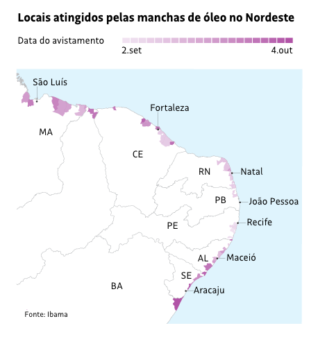
The spill stretches over 1,500 kilometers (932 miles) of Brazil's northeast coast, affecting 46 cities and around one hundred of the country's nicest beaches since being first detected on Sept. 2.

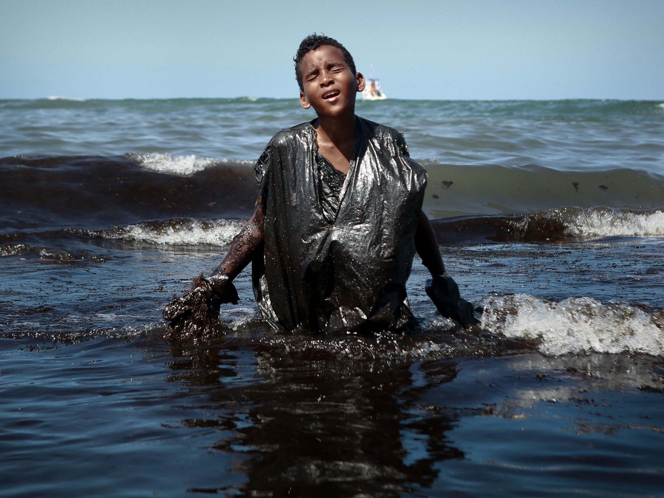
 Boy comes out of the sea full of oil in Cabo de Santo Agostinho, Pernambuco
Photo: Leo Malafaia / AFP

Brazilian television has shown slicks at sea and oil puddles along shores, as well as turtles covered in black tar.
Other marine life has also been found dead.


The Brazilian Institute of the Environment and Renewable Natural Resources, Ibama, said state oil company Petrobras analyzed the spill and determined it came from a single source.
However, it said, a molecular analysis of the crude showed that it was not produced in Brazil, the world's 9th largest crude producer at 3.43 million barrels a day.

Petrobras reported that "the oil found is not produced by Brazil.
Ibama requested support from Petrobras to work on beach cleaning.
In the coming days, the company will make available a contingent of about 100 people," the environmental institute announced in a statement.

 see Sentinel Vision portal
200: Number of different locations with crude oil in ocean and/or on beach. (confirmed locations. Probably more not recorded yet)
77: Number of cities that have seen oil on beaches.
9: Number of states effected. 

Extent of Damage

The tests were done at the Petrobras Research Center (Cenpes) in Rio de Janeiro.
So far, 105 crude oil spills have been detected.

Since the beginning of September, Ibama, together with the Federal District Fire Department, Brazil's navy and Petrobras, have been investigating the causes.
Ninety-nine locations in 46 municipalities in 8 states have been affected, including Maranhão, Piauí, Ceará, Rio Grande do Norte, Paraíba, Pernambuco, Alagoas and Sergipe. In the Northeast, only the state of Bahia has not been affected yet.

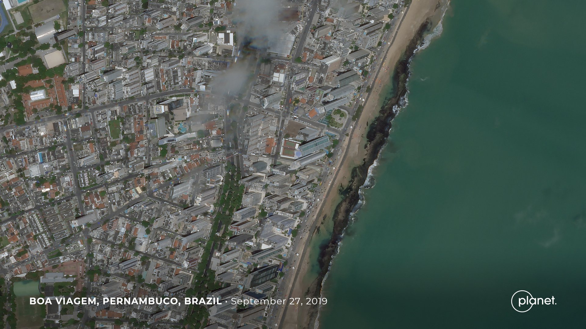
 Imagery captured by Planet SkySats on September 27th.

Authorities were still conducting cleaning procedures on the Potiguar coast earlier this week.

Links :

Thursday, October 24, 2019

Massive citizen science effort seeks to survey the entire Great Barrier Reef

By collecting images and GPS data from citizen divers, scientists can get a better sense of the health of the entire Great Barrier Reef.
(Damian Bennett)

From Smithsonian by Jessica Wynne Lockart

Only about 1,000 of 3,000 individual reefs have been documented, but the Great Reef Census hopes to fill in the gaps

In August, marine biologists Johnny Gaskell and Peter Mumby and a team of researchers boarded a boat headed into unknown waters off the coasts of Australia.
For 14 long hours, they ploughed over 200 nautical miles, a Google Maps cache as their only guide.
Just before dawn, they arrived at their destination of a previously uncharted blue hole—a cavernous opening descending through the seafloor.

 Great Barrier Reef in the GeoGarage platform

After the rough night, Mumby was rewarded with something he hadn’t seen in his 30-year career.
The reef surrounding the blue hole had nearly 100 percent healthy coral cover.
Such a find is rare in the Great Barrier Reef, where coral bleaching events in 2016 and 2017 led to headlines proclaiming the reef “dead.”
“It made me think, ‘this is the story that people need to hear,’” Mumby says.

The expedition from Daydream Island off the coast of Queensland was a pilot program to test the methodology for the Great Reef Census, a citizen science project headed by Andy Ridley, founder of the annual conservation event Earth Hour.
His latest organization, Citizens of the Great Barrier Reef, has set the ambitious goal of surveying the entire 1,400-mile-long reef system in 2020.
“We’re trying to gain a broader understanding on the status of the reef—what’s been damaged, where the high value corals are, what’s recovering and what’s not,” Ridley says.

High resolution bathymetry data trove released
Araft of detailed new bathymetry datasets have been published on the AusSeabed Marine Discovery Portal. 
 
While considered one of the best managed reef systems in the world, much of the Great Barrier Reef remains un-surveyed, mainly owing to its sheer size.
Currently, data (much of it outdated) only exists on about 1,000 of the Great Barrier’s estimated 3,000 individual reefs, while a mere 100 reefs are actively monitored.

Researchers instead rely on models, which has left gaps in knowledge.
In the last two years, our understanding of how ocean currents dictate the reef’s ability to survive has improved.
According to Mumby, spawn from as few as three percent of sites provides new life to over half of the reef.
Those key reefs, however, still need to be identified.
“You can’t prevent bleaching or cyclones, but you can protect critically important sources of larvae,” he says.
An accurate survey will help to manage coral-hungry Crown-of-thorns starfish, as well inform future restoration project sites.

The majority of individual reefs that make up the Great Barrier Reef have not been directly surveyed.
(Damian Bennett)

The Great Reef Census is not the first attempt to use citizen science to survey the reef.
One such program, Reef Check, has been relying on citizens for 18 years—but it only monitors 40 key sites.
Eye on the Reef, an app from the Great Barrier Reef Marine Park Authority, encourages users to upload significant sightings, such as bleaching events, Crown-of-thorns starfish and mass spawning events.
But the new census will mark the first attempt to survey the entire reef system.

But the ambitious research program hinges on laypeople, meaning the data gathered could be of questionable scientific value.
Citizen science is notoriously problematic, owing to deviations from standard procedures and biases in recording.
For example, contributors to Eye on the Reef are more likely to record the spectacular (whale sharks, dugongs and humpback whales) than the common (starfish).

In 1992, Mumby’s first research project was analyzing reef survey data from citizen scientists in Belize.
The results, he admits, were less than brilliant.
“There are many citizen programs where the pathway between the data collected and the actual usage by management can be somewhat opaque,” he says.

Yet, Mumby believes that the Great Barrier Reef Census is different.
The program has a clear connection to both research and policy, he says.
Unlike other citizen science efforts, unskilled volunteers won’t be asked to estimate or monitor coral cover.
Participants will do the most simplistic of grunt work: uploading 10 representative photos of their diving or snorkelling site with a corresponding GPS tag.
This basic field data will then be used by the University of Queensland, which is already using high-resolution satellite images and geomorphic modelling to map the reef and predict the types of local ecosystems present.

National Oceanic and Atmospheric Administration diver Kelly Gleason injects a crown-of-thorns starfish with with ox bile, a natural substance that kills the creature but does not harm the reef.
(Greg McFall, NOAA Dive Program)

The project is critically important to understanding the reef, but it comes with limitations, says David Kline, a coral reef ecologist at the Smithsonian Tropical Research Institute.
According to Kline, satellite imaging is only capable of penetrating to depths of about 5 meters, although some satellite mapping has achieved about 20 meters in ideal conditions.
This leaves the deep-water mesotrophic reefs—which are less likely to suffer from bleaching and may be critical for reef recovery—under-studied.
Some are located as deep as to 2,000 meters underwater.
“To really [survey] the entire Great Barrier Reef in a meaningful way, you need AUVs [autonomous underwater vehicles], drones, airplanes with multi-spectral imagery, and high-resolution satellites—and you need to be able to link the data between these different levels,” Kline says.

Kline is currently working with the University of Sydney’s Australian Centre for Field Robotics, where engineers are training AUVs to gather high-resolution imagery of the reefs, including mesotrophic reefs.
This information can then be used to train machine learning algorithms to map the entire system.

However, Kline says it will likely be another 5 to 10 years before a fleet of AUVs is ready to efficiently map large areas such as the Great Barrier Reef.
“Until then, we need ambitious projects to start making progress toward that goal,” he says.
The Great Barrier Reef Census and the satellite mapping from the University of Queensland is a good start.

But even if the census’s methodology leads to stronger scientific data than previous efforts, the reef’s prognosis is still bleak.
If global greenhouse emissions continue to rise at their current rate, it’s predicted that mass bleaching events, which have occurred four times in the past 20 years, will occur annually from 2044 onward.

If successful, the Great Barrier Reef Census will be the world’s largest collaborative scientific survey.
And Ridley thinks if reports of the reef’s alleged death didn’t propel people to action, maybe reports of its ability to survive in the face of adversity will.

“We want the citizens to be helpful from a science perspective—but we also want people to give a shit,” Ridley says.
“The world’s not moving fast enough toward net-zero emissions.
Can the Great Barrier Reef be a point of inspiration, rather than a point of doom? I don’t know.
But we’re giving it a bloody shot.”

Links :
Wednesday, October 23, 2019

Winds of change: the sailing ships cleaning up sea transport

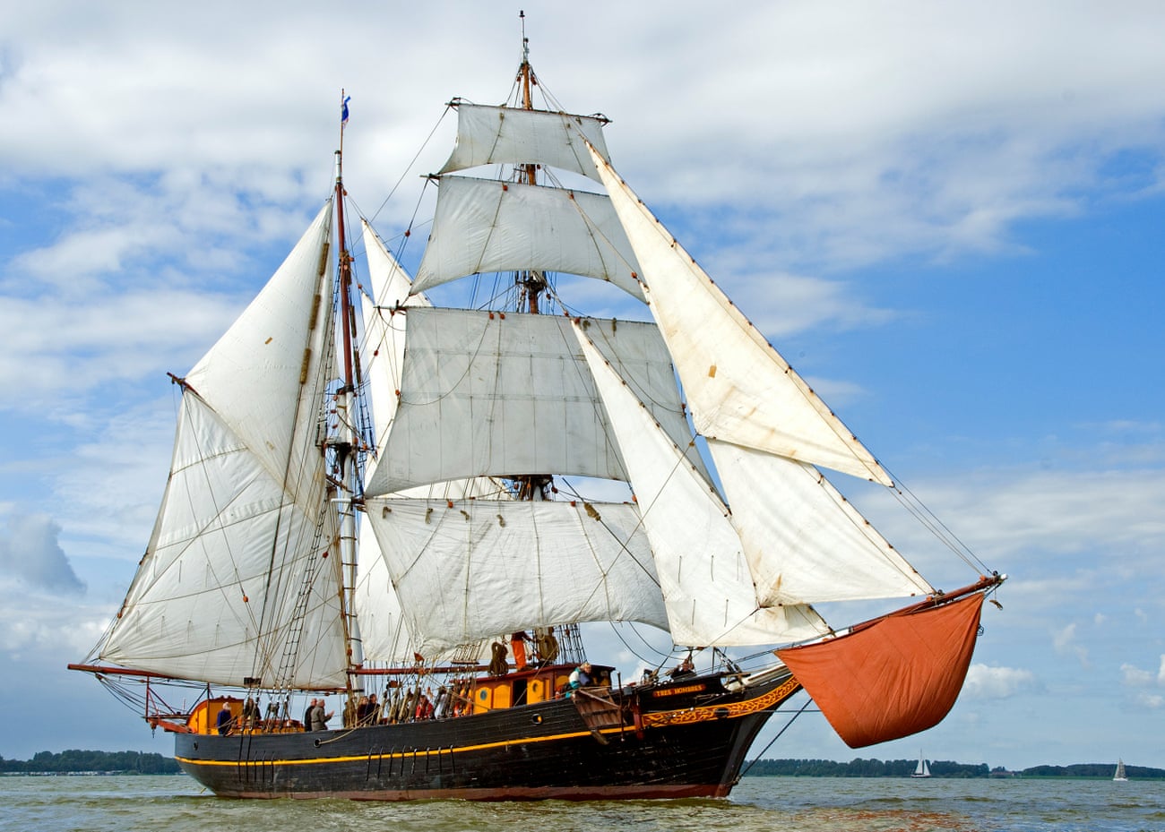
Fairtransport ship Tres Hombres, which transports coffee for Shipped by Sail

From The Guardian by Nicola Cutcher

Ethically minded entrepreneurs are turning back the clock to sweep the scourge of bunker fuel from the oceans

They fan out across the seas like a giant maritime dance, a ballet of tens of thousands of vessels delivering the physical stuff that has become indispensable to our way of life: commodities and cars, white goods and gas and grains, timber and technology.

But shipping – a vast industry that moves trillions of pounds-worth of goods each year – is facing an environmental reckoning.
Ships burn the dirtiest oil, known as bunker fuel; a waste product from the refinery process, literally scraping the bottom of the barrel, the crud in crude.
It’s so thick that you could walk on it at room temperature.

As a result, shipping is a major polluter – responsible for about 2.5% of global carbon emissions.
Not surprisingly, innovators are starting to wonder if there is another way.

“Around 90% of everything we consume [in Britain] spends some time at sea, so we urgently need to make the transportation of goods more sustainable,” says Will Templeman, an environmental scientist-turned-entrepreneur.

Templeman’s eureka moment came during a visit to the supermarket when he was agonising over the food miles in his trolley.
He wondered if it would be possible to transport things such as coffee and chocolate with zero emissions.
Then he remembered that this was how goods used to travel.
By sailing ship.

A quick online search revealed that a Dutch company was doing exactly that.
The owners of Fairtransport were inspired to revive sail cargo after witnessing at first hand the yellow smog caused by commercial vessels.
They restored two ships, a 70-year-old minesweeper renamed the Tres Hombres and a wooden ketch called Nordlys that dates back to 1873.
Templeman arranged to board the Tres Hombres, sailing from the Azores to the Netherlands.
“I was watching the ocean and it came like a ghost ship through the dawn mist. It looked like a pirate vessel. I was so excited.”

He dreamed of launching his own ship but realised that the first step was to make full use of the sailing vessels already in service.
He set up as a broker and together with his business partner, Will Adeney, went in pursuit of products to sell.
They found their perfect olive oil in Portugal and arranged to have it shipped to Devon on board the Nordlys.
They later sourced coffee beans in Colombia, and shipped them to Europe on the Tres Hombres.
Their business, Shipped by Sail, was born.

It joined a growing network of brokers and sailors passionate about transporting goods by wind power.
The next step: to boost demand for this kind of transportation.
“Consumers already understand organic produce and fair trade, and the next step is clean transport,” says Cornelius Bockermann, who founded Timbercoast, a German sail cargo company that has restored a schooner from 1920, and is now refitting a second.

Clean transport is the missing link, as many so-called sustainable or ethical goods are currently carried on ships that pollute the air and sea.
The perfect example of this is plant-based meat, shipped around the world from California.

British couple Marcus and Freya Pomeroy-Rowden built their ship, the Grayhound, as a replica of an 18th-century lugger, and carry cargo between the UK and France, bringing West Country ale to Brittany and French wine to Cornwall.
They supply small businesses along the way, for example providing wines to Dibble & Grub on the Isles of Scilly.
The couple enjoy the lifestyle of spending months at sea, making a living, while making a difference.
Marcus says they’re bringing trade back to a human scale.
“We’re taking quality products and transporting them direct to a distributor.
We can understand and explain the whole chain for our products, from manufacture to the table.”

In France, TransOceanic Wind Transport has developed a labelling system with a voyage number, allowing the customer to see how products reached them.

Broker Alex Geldenhuys launched New Dawn Traders in the UK about six years ago and is still developing her “voyage co-op” model, bringing together farmers, ships and buyers.


Geldenhuys has been inspired by local food communities and vegetable box schemes and wants to extend that movement overseas, building relationships with distant farmers to bring ethically produced, high-quality produce to the UK with a carbon footprint that is close to zero.
She is seeking “port allies” to promote the idea in coastal communities, encouraging customers to pre-order products from the ships and turning collection events at the docks into celebrations of the whole process.

A few weeks ago a French schooner, De Gallant, sailed into Bristol laden with produce from Portugal; the first time a tall ship had brought cargo to the city for decades.
It was an emotional moment for Geldenhuys and the climax of years of work.
“It was beautiful to watch her sailing in under the suspension bridge,” she says.
Local people milled around the ship, sampling olive oil, almonds and wines.

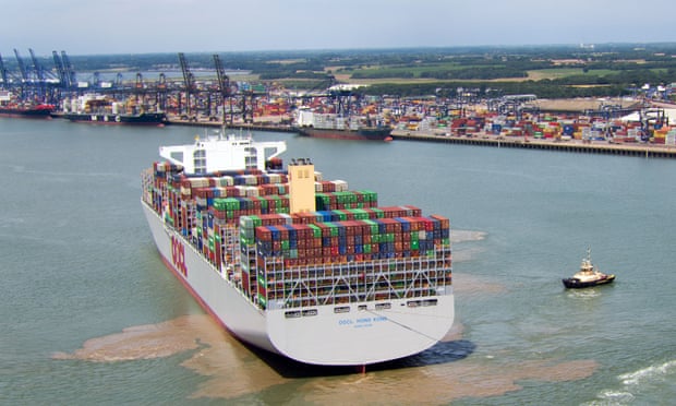
Hong Kong, at the time the world’s largest container ship and capable of carrying 21,413 containers, docks in Felixstowe, Suffolk, in 2017.
Photograph: Steve Parsons/PA

Geldenhuys acknowledges that currently she can only deliver to her customers twice a year.
Templeman says: “Restaurants and other businesses need a regular supply to be reliable.
So we’re warehousing goods.”
Olive oil on De Gallant was transported by electric van to a restaurant in Bristol.

The biggest challenge for sail cargo is scale.
There are currently only a few small ships operating.
Most companies feel that the time is ripe for expansion and have plans to build larger vessels.
One of the founders of Fairtransport, Jorne Langelaan, has set up a new venture called EcoClipper to facilitate emission-free shipping worldwide.
He is planning for more sailing ships running more routes more frequently.


In Costa Rica, Canadian Danielle Doggett is building a sailing ship called Ceiba, which looks set to become the largest in the world.
The project uses tropical trees that have fallen in storms, and more trees are planted as the building proceeds.
Ceiba will be able to carry 250 tonnes of cargo (Tres Hombres and De Gallant take 35 tonnes), which is equivalent to around 10 containers.
Yet this is still much smaller than the historic tea clippers, such as the Cutty Sark, and dwarfed by the largest modern container ships, which can carry more than 20,000.

The shipping industry knows that change is on the horizon.
From next year new regulations will further limit sulphur oxide emissions from ships.
The International Maritime Organization has announced its ambition to halve greenhouse gas emissions by 2050.
The world’s largest shipping company, Maersk, has gone further, pledging to be carbon-neutral by 2050.

Templeman acknowledges that the largest companies want to make their fleets more energy-efficient, but points out: “We’re coming from the opposite direction and offering emission-free shipping right now, while asking what sail shipping could have been with another 100 years of development.”
Marcus Pomeroy-Rowden adds: “We’re waving a flag to say the world can’t carry on as it is.
We’re also showing what can be done in a different way.”

Bockermann stresses that industrial shipping is only cheap because it externalises the environmental costs.
“What you normally pay a shipping company doesn’t account for the damage to the environment, pollution or health.
Our costs are comparatively high but if you had to pay for the damage of conventional shipping then we wouldn’t seem expensive.”

Geldenhuys adds: “We might not be the solution to how everything is shipped in the world but we can make people think about what they’re buying and how it’s getting here.
It’s easy to feel overwhelmed and helpless.
But we can all do something.
We don’t need one solution to everything, we need a thousand solutions that can exist simultaneously.”

Links :

Tuesday, October 22, 2019

Ocean acidification can cause mass extinctions, fossils reveal

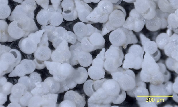
Heterohelix globulosa foraminifera isolated from the K-Pg boundary clay at Geulhemmerberg in the Netherlands, shown at 8x magnification.
Study confirms fear that intense ocean acidification portends ecological catastrophe: ‘We have been warned’
Photograph: Michael J. Henehan/PNAS

From The Guardian

Carbon emissions make sea more acidic, which wiped out 75% of marine species 66m years ago

Ocean acidification can cause the mass extinction of marine life, fossil evidence from 66m years ago has revealed.

A key impact of today’s climate crisis is that seas are again getting more acidic, as they absorb carbon emissions from the burning of coal, oil and gas.
Scientists said the latest research is a warning that humanity is risking potential “ecological collapse” in the oceans, which produce half the oxygen we breathe.

The researchers analysed small seashells in sediment laid down shortly after a giant meteorite hit the Earth, wiping out the dinosaurs and three-quarters of marine species.
Chemical analysis of the shells showed a sharp drop in the pH of the ocean in the century to the millennium after the strike.

This spike demonstrated it was the meteorite impact that made the ocean more acidic, effectively dissolving the chalky shells of many species.
Large-scale volcanic activity was also considered a possible culprit, but this occurred over a much longer period.

The Cretaceous-Palaeogene boundary at Geulhemmerberg, in the Netherlands, where boundary clay samples were taken.
credit : Michael Henehan

The oceans acidified because the meteorite impact vaporised rocks containing sulphates and carbonates, causing sulphuric acid and carbonic acid to rain down.
The mass die-off of plants on land after the strike also increased CO2 in the atmosphere.

“We show ocean acidification can precipitate ecological collapse,” said Michael Henehan at the GFZ German research centre for geosciences in Potsdam, who led the study.
“Before we had the idea, but we did not have the empirical proof.”

The researchers found that the pH dropped by 0.25 pH units in the 100-1,000 years after the strike.
It is possible that there was an even bigger drop in pH in the decade or two after the strike and the scientists are examining other sediments in even finer detail.

Henehan said: “If 0.25 was enough to precipitate a mass extinction, we should be worried.” Researchers estimate that the pH of the ocean will drop by 0.4 pH units by the end of this century if carbon emissions are not stopped, or by 0.15 units if global temperature rise is limited to 2C.
Henehan said: “We may think of [acidification] as something to worry about for our grandchildren.
But if it truly does get to the same acidification as at the [meteorite strike] boundary, then you are talking about effects that will last for the lifetime of our species.
It was hundreds of thousands of years before carbon cycling returned to normal.”

The research, published in the journal Proceedings of the National Academy of Sciences, analysed sediments that Henehan encountered by chance, during a conference field trip in the Netherlands.
The sediments, which straddle the moment of the impact, lie in caves that were used by people hiding from the Nazis during the second world war.
“It was so lucky,” said Henehan.

The rocks contained foraminifera, small-shelled marine organisms.
“In the boundary clay, we managed to capture them just limping on past the asteroid impact.
But you can see their shell walls were much thinner and poorly calcified after the impact,” he said.

It was the knock-on effects of acidification and other stresses, such as the “nuclear winter” that followed the impact, that finally drove these foraminifera to extinction, he said: “You have the complete breakdown of the whole food chain.”
He said oceans also faced additional stresses today, from global heating to widespread pollution, overfishing and invasive alien species.

When the Chicxulub asteroid landed in what is today Mexico, it didn't just extinguish the dinosaurs. It devastated life in the oceans, too.

Phil Williamson, at the University of East Anglia, who was not involved in the research, said: “It is relatively easy to identify mass extinction events in the fossil record, but much harder to know exactly what caused them. Evidence for the role of ocean acidification has generally been weak, until now.”
He said caution was needed in making the comparison between the acidification spike 66m years ago and today: “When the asteroid struck, atmospheric CO2 was naturally already much higher than today, and the pH much lower.
Furthermore, large asteroid impacts cause prolonged darkness.”
Williamson added: “Nevertheless, this study provides further warning that the global changes in ocean chemistry that we are currently driving have the potential to cause highly undesirable and effectively irreversible damage to ocean biology.”

Henehan said the generally lower ocean pH 66m years ago might have made shelled organisms more resilient to acidification.
“Who knows if our current [marine] system is as well set up to cope with sudden acidification?”

Links :

Monday, October 21, 2019

Croatia (HHI) update in the GeoGarage platform

25 new nautical rasterized charts added & 58 charts updated
see GeoGarage news

On May 22., 2019. for the official use of 25 new cells of electronic navigation Cards (ENC).
Thus, the Croatian Hydrographic Institute (HHI) enabled availability and use of a total of 207 cells of enc all upotrebnih groups, which announces with special pleasure and pride.

The first package of enc's hhi was issued 12 years ago (February 2007.), and for priority areas intended for sailing very fast boats (High Speed Craft).
He continued to release new packages according to established priorities, leading the criteria to ensure the coverage of the most important areas of the solas ships in the international
After the complete coverage of the plovidbenih area of solas ships, hhi continues to create and publish new enc for areas of smaller ports and sailing smaller boats (Non-Solas) and yachts.

By establishing production and distribution of official enc, hhi has greatly contributed to the improvement of the hydrographic-navigation element of safety, which has been fulfilled and internationally downloaded the obligation of ensuring the availability of enc on ships to a certain deadline, and for the area of the

Information about all the published cells of enc is available to users in the print edition of the catalogue of maritime cards and publications, as well as on the website of hhi -


25 New Electronic Navigation Charts (ENC) Released On July 17, 2019, 25 new electronic navigation charts (ENCs) were issued for official use.
This enabled the Croatian Hydrographic Institute (HHI) to make available and use a total of 232 ENC cells of all use groups.
Official electronic charts can be obtained through the regional coordinating center PRIMAR and its network of authorized distributors.
Information on all published ENC cells is available in the printed edition of the Catalog of Maritime Maps and Publications as well as on the HHI website

Venezuela (DHN / INCANAL) update in the GeoGarage platform

26 inland nautical raster charts (INCANAL) added for the Orinoco river

Satellites to monitor whale strandings from space


Dr Jennifer Jackson: "Satellites get us to whales in those places that are hard to reach"

From BBC by Jonathan Amos

Scientists developing techniques to count great whales from space say the largest ever recorded mass stranding event was probably underestimated.

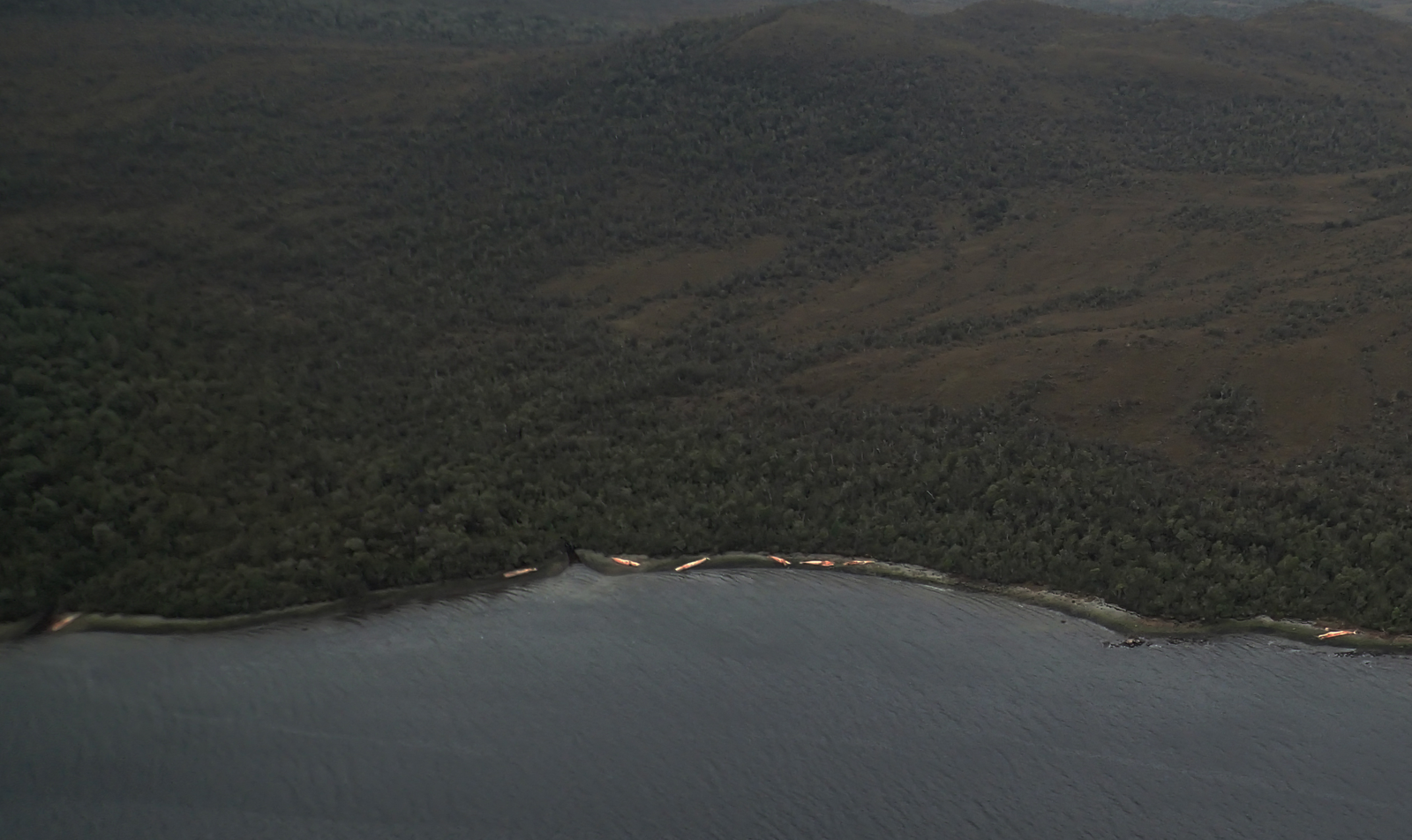
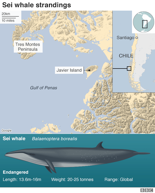
The carcasses of 343 sei whales were spotted on remote beaches in Patagonia, Chile, in 2015 - but this survey work was conducted from planes and boats, and carried out many weeks after the deaths actually occurred.

However, an analysis of high-resolution satellite images of the area taken much closer in time to the stranding has now identified many more bodies.

It's difficult to give a precise total for the number of whales involved but in one sample picture examined by researchers, the count was nearly double.

The new investigation, published in the Plos One journal, was undertaken as a proof of principle exercise by the British Antarctic Survey (BAS) and various Chilean organisations.

The WorldView-2 satellite will see features at the surface larger than half a metre across 
Image copyright Satellite image ©2019 Maxar Technologies

It's not easy to see an object, even one as large as a great whale, from several hundred kilometres up in space, but the international team believes the capability of modern satellites now makes this a practical task.

Being able to detect strandings more effectively will inform the ongoing conservation of whales.
It will also flag potentially deteriorating ocean conditions, something the fishing industry for example will be keen to know about.

The monitoring of whales from orbit is set therefore to become a powerful tool with which to assess the state of the environment.
"The technology is getting better all the time," said Dr Carlos Olavarría from the Centre for Advanced Studies in Arid Zones (CEAZA), La Serena, Chile.
"In this study, we were using 50cm resolution images, but the satellites now can see 30cm. In the future, we'd like also to be able to analyse the pictures automatically, rather than manually; and I'm sure as more minds are applied to the problem, this will become possible," he told BBC News.

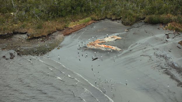
Aerial survey image of stranded whales
Photo: Hausermann/BAS

What happened in the stranding event?


It's not clear why such a large number of sei whales beached en masse in early 2015.
One reason for the uncertainty is that researchers were very late in getting to the scene to run tests to establish the cause.

That was in part because the stranding occurred in a very thinly populated, and difficult to access, area of central Patagonia called the Gulf of Penas.
It has multiple fjords, channels and islands, and the deaths only came to light by accident when an unrelated expedition chanced on the carcasses.

This was a good month after the event and by then the sei whales had already started to decompose. Nonetheless, a ground team's inquiries led it to the conclusion that the cetaceans had probably been poisoned after consuming toxic algae.

Image copyright Satellite image ©2019 Maxar Technologies
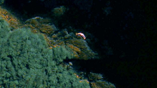
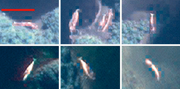
Image caption The animals turn a pinkish orange when they decompose (Scale bar: 20m) 


How did the satellites gauge the event's size?

The planes and boats that surveyed the Gulf of Penas counted more than 340 dead whales, but the complex geography meant that some bodies almost certainly were missed.

"The aerial survey was done on a huge scale and was very impressive, but it's possible some of the carcasses got washed back out to sea in storms and simply weren't counted. The 343 number was only ever a best estimate," said BAS whale expert Dr Jennifer Jackson.

The high-resolution satellite imagery allowed scientists to do a count much closer in time to the event itself.
The researchers used pictures from the WorldView-2 spacecraft which can discern features larger than 50cm across from an altitude of 700km.
For a whale that may be 10-15m in length, this produces a good outline of the animal's overall shape, including its distinctive fluke.

The team examined two archive images of the gulf from mid-March in 2015.
In one, they counted slightly fewer whales than in the aerial survey work; but substantially more in the second picture.

Image copyright V.Haussermann
Image caption The aerial survey was conducted many weeks after the event actually happened 

So, how useful is satellite observation?


It's possible to see the big baleen whales, like the sei whale, from orbit, and with the WorldView series of satellites now offering 30cm resolution, the task should become even easier - and for smaller whale species too, not just the baleens.

Scientists could monitor any beach in world, but especially those remote coastlines where cetacean strandings are a regular occurrence - in places such as Tasmania, New Zealand, the Falkland Islands, and obviously South American Patagonia.

But it would be even easier if an automated detection system could be developed. The team tried this by training a computer to look for the spectral (light) signature of a dead whale in the Gulf of Penas (the seis turned pink and orange as they decomposed).

However, this approach was less successful than manual inspection of the pictures. The algorithms, though, are bound to improve.

"There are many more satellites planned to be launched with 50cm and 30cm resolution, so if we could automate the system it might be able to find these stranding events almost as they happen," BAS remote sensing specialist Peter Fretwell told BBC News.

Media captionZoom in to the Gulf of Penas
(satellite image ©2019 Maxar Technologies)

How will whales benefit from this science?

Getting to the scene of a stranding quickly will give greater certainty to the cause of an event.
Sei whales have continued to wash up in the Gulf of Penas every year since 2015 and so it's vital scientists understand fully what's happening off-shore.

Strandings more widely can be useful markers of the status of a population.
The dissection of washed-up bodies (a necropsy) will be an opportunity to investigate the general health of animals, and to study aspects of their behaviour such as their dietary habits.

Even just the pattern of strandings will provide information on which whales are present in an area and their likely numbers.
All this detail is facilitated by a more rapid response.

"It's important ecologically," commented Andrew Baillie, the Cetacean Strandings Officer at London's Natural History Museum.
"[Whales] are often top predators and they are very involved in the marine ecosystem. If they are suffering because of any actions of humans then we need to monitor that and mitigate it if possible."

Links :

Sunday, October 20, 2019

Magical video of whales blowing bubbles to catch dinner

A humpback whale swimming in a circular pattern while blowing bubbles to create a “net” to encircle its prey.
It’s a regular occurrence in the cold blue-green waters of Southeast Alaska, and University of Hawaiʻi at Mānoa researchers and their collaborators have captured it on video from an amazing whale’s-point-of-view along with aerial video.
 
From CNET by Amanda Kooser

Get both a drone's-eye and an underwater view of how humpback whales use bubble-net fishing to round up krill.

Humpback whales have a clever way of catching prey.
They don't have thumbs to sit around weaving fishing nets with, so they use what they've got: bubbles from their blowholes.
A team led by researchers at the University of Hawaii at Manoa captured spectacular footage of humpback whales using a technique called bubble-net fishing in the waters near Alaska.
The whales were packing on the pounds before heading to Hawaii to breed.

Bubble-net fishing involves a group of whales near the ocean surface rounding up fish or krill inside a circle of bubbles exhaled from their blowholes.
As the whales rise toward the surface, they corral the fish in the bubble net.
It's a cooperative behavior that results in a good meal for the participants.  
The team used drones to capture the view from above.
Cameras and sensors attached to the whales by suction cups gathered video and data from the whale's point of view.
Put the two together and you get an incredibly detailed look at this fascinating feeding behavior.  
Lars Bejder, director of the university's Marine Mammal Research Program, called the footage "groundbreaking." 
"We're observing how these animals are manipulating their prey and preparing the prey for capture.
It is allowing us to gain new insights that we really haven't been able to do before," he said in a release on Sunday.
The National Oceanic and Atmospheric Administration has noted a drop in the number of humpback whale sightings around Hawaii in recent years.
The Marine Mammal Research Program is looking into what might be causing a possible decline in the population.
Scientists are concerned about the impact of climate change and a loss of food resources.
We can't just call on the crew of the USS Enterprise like in Star Trek IV: The Voyage Home to save the whales.
We have to start with gathering solid data on their feeding habits and changes in habitat.
This video footage is both beautiful and useful as scientists work to understand what's happening with these magnificent animals.

Links :