Saturday, March 19, 2022

A new generation of data standards

 Supporting the future of navigation and the future of our oceans

The next generation of navigation solutions will transform the way we use marine data – supporting safer, more efficient voyages, advancing the prospect of autonomous shipping, and underpinning an even wider range of decisions made by mariners and shore-based users.
At the heart of these new solutions is the new S-100 data standards; but what do these standards mean? And how will they support decision making?
The new data standards can also provide more insightful, more usable information to support improved decision-making on sustainability and protection of the marine environment.
This new animated digital twin of the real world, developed by the UK Hydrographic Office, briefly explores these data standards in context, showing the wide range of benefits they can unlock in the changing maritime landscape.
The way we manage the world’s oceans is evolving, driving autonomy, connectivity and smarter use.
This will be regulated by a new generation of data standards - unlocking a wide range of benefits, from supporting safety and efficiency to protecting the marine environment.
These standards will empower users to support the future of navigation and the future of our oceans.
This video explores the International Hydrographic Organization (IHO) S-100 Data Standards in context and the benefits they can bring to a wide range of users, including: 
› S-101 Electronic Navigational Charts (ENCs) 
› S-102 Bathymetric Surface 
› S-104 Water Levels 
› S-111 Surface Currents 
› S-121 Maritime Limits and Boundaries 
› S-122 Marine Protected Areas (MPAs) 
› S-123 Marine Radio Services 
› S-124 Navigational Warnings 
› S-127 Marine Traffic Management 
› S-128 Catalogue of Nautical Products 
› S-129 Under Keel Clearance Management 
› S-201 Aids to Navigation Information 
› S-412 Weather Overlay

Friday, March 18, 2022

A radar-illuminated ocean reveals dark fleets

Satellite radar imagery reveals the true scale of vessel activity in the Mediterranean Sea.

From GlobalFishing Watch by David Kroodsma

Satellite radar imagery is lighting up our view of previously unseen fishing patterns around the world


Last week, we announced the winners of the xView3 contest to use satellite radar imagery and artificial intelligence to reveal vessels at sea.
This week, we give you a gist of what this technology can do when deployed at scale.

We are using radar to “see” every large vessel on the ocean—including the countless ones that don’t publicly broadcast their locations, and are “dark” in monitoring systems.Satellite radar imagery reveals the true scale of vessel activity in the Mediterranean Sea.

To accomplish this goal, our automated cloud pipeline crunches petabytes of satellite radar imagery, processing about 400 scenes per day, and extracting more than 20,000 daily detections.
These images are then run through a sophisticated matching system to pair them with known vessel locations based on the automatic identification system, or AIS.
We are also developing a model to differentiate which of these vessels are fishing vessels, similar to the models in xView3, and we are excited about the results—it will soon be possible to map the dark fishing fleet globally.
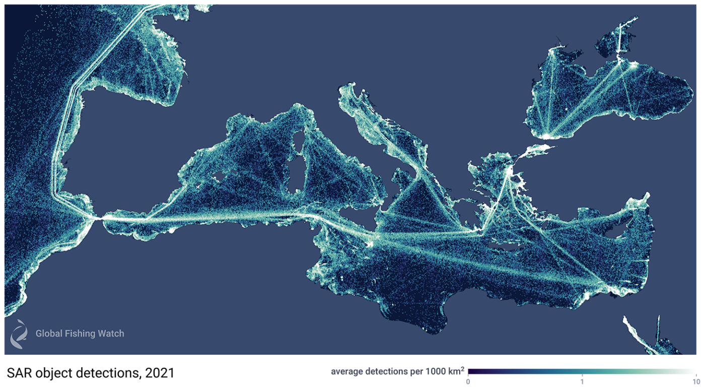
Shown above is a subset of a global dataset of one year’s worth of detections, showing off all vessel traffic in the Mediterranean Sea.

We are excited to share a preliminary view of this radar data in our marine manager portal, where you can view radar detections for a full year across the Mediterranean Sea.
Shown is a subset of a global database of almost nine million detections extracted from 140,000 radar images taken by the European Space Agency’s Sentinel-1 satellites in 2021, a task made possible by Global Fishing Watch’s big data pipelines and our unique visualization technology.
 
 
Big data visualization technology allows interactions with millions of satellite detections.
Click to visit workspace.
 
Since we have matched these detections to our AIS data, you can click on the map and see which vessels were broadcasting AIS and which were “dark.” This map also includes lots of fixed infrastructure, such as oil platforms and wind turbines.
Future versions of the map will classify these structures to distinguish them from dark vessels.
We also aim to share the entire, global dataset in the near future.

A new age of mapping possibilities


Why is this so exciting? Because we can now see the incredible amount of fishing along the north coast of Africa that was hidden from view before—and this is just the beginning.
Zoom into the coastal waters of Africa and filter the map for vessels that are not matched to AIS, and you’ll see a great amount of activity.
Visit the map workspace in our marine manager portal.

Until now, much of our “seeing” of human activities at sea has relied on information from AIS transponders, such as those that the EU requires on all fishing vessels over 15 meters in length.
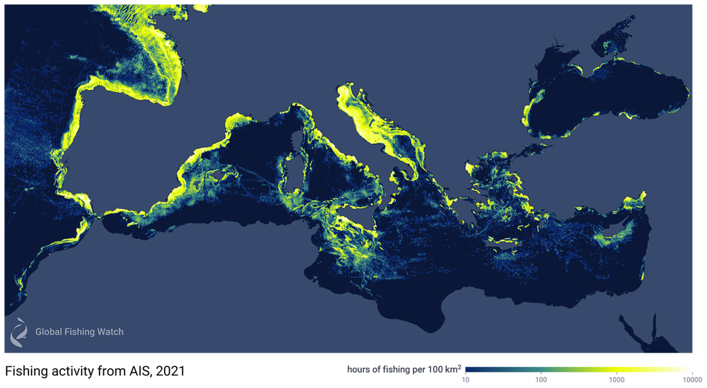
To illustrate how much more we are now able to detect with the addition of satellite radar imagery, the figure below shows the fishing activity we are able to see if we only use AIS data for 2021.
With this technique alone, the waters off of North Africa look practically empty and the picture is incomplete.
 
Fishing activity in the Mediterranean Sea and surrounding waters in 2021, when detected using AIS data alone, shows AIS-broadcasting vessels (yellow areas), but fails to show many non-broadcasting “dark vessels”— for example, very little is shown along North Africa. 
This image is a subset of a global dataset of fishing activity, which includes 1.5 billion GPS messages from about 70,000 fishing vessels.

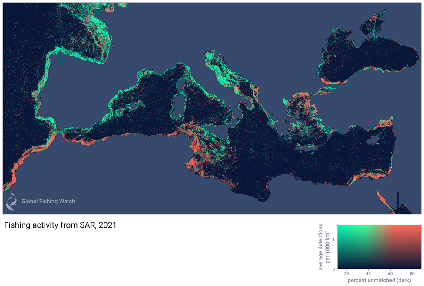
By comparison, the next figure shows the density of vessel traffic across the Mediterranean and nearby waters for 2021 when we use SAR and machine learning to detect and classify vessels—technology that we can now automate and scale globally to reveal unseen fishing patterns around the world.
 
Fishing activity in the Mediterranean Sea and surrounding waters in 2021 is detected with Synthetic Aperture Radar (SAR).
Shown is the intensity of fishing and the fraction of vessels that were “dark,” or not broadcasting AIS (orange areas).


Suddenly, North Africa lights up with intense activity by vessels that are not broadcasting AIS but are now visible with our radar detection technology.
What’s more, our machine learning models say these are likely fishing vessels.

We are highlighting the Mediterranean in this initial release of data because radar imagery will be of immense help in this region over the next few years.
Our work in these waters has included three reports that analyze fishing activity inside fisheries restricted areas that protect vulnerable marine ecosystem habitat.
These reports draw on radar imagery data to identify potential vessels not broadcasting AIS.
We have also launched a dedicated Mediterranean and Black Sea marine manager portal that includes fisheries restricted areas and cold water corals locations.

We should note that although vessels that do not broadcast their position are sometimes linked to unlawful activity—as we found in a study of rampant illegal fishing in North Korea—“dark fishing” usually isn’t illegal.
Many of these vessels not broadcasting their position are actually not required to do so.
For example, countries along the coast of Africa or Albania in the Adriatic Sea don’t have AIS requirements as they are not members of the EU.
This lack of information is precisely what has clouded our ability to map out and understand the true footprint of fishing.

A next generation of modeling

To push the boundaries of what is possible with radar imagery, we co-hosted a competition to build better algorithms to detect vessels with this imagery.
Working with the U.S.
Defense Innovation Unit, and supported by the U.S.
Coast Guard, National Oceanic and Atmospheric Administration and the National Maritime Intelligence-Integration Office, we helped conduct the xView3 computer vision challenge to identify dark fishing vessels using satellite radar and machine learning.
For this contest, we processed and prepared thousands of images, provided detailed training data by partially drawing on our models, and challenged contestants to build the best possible algorithm.

xView3’s top contestant, BloodAxe, developed a model using complex scans that can estimate the size of a vessel and whether it is a fishing vessel.
This model did especially well close to shore, where it can be extremely difficult to differentiate vessels from rocks or human-made structures.
The model, now freely available, is something we will be studying in our effort to build a second generation model.
The other top algorithms, all open source, are now also available to share and use.

We are entering a new, exciting age in the monitoring of human activity at sea.
At Global Fishing Watch, we started our work by tracking vessels that broadcast their GPS positions.
With the rise of satellite radar technology and advanced machine learning, we are now transitioning to the ability to see every large vessel at sea.
Over the next few months, we will be scaling these models to estimate the true, global footprint of humans on the ocean.

Links :

Thursday, March 17, 2022

Visualizing shipping lanes from Sentinel-1


I found in Twitter [1,2,3] that a simple way to visualize the sea lanes is to compute the maximum of each pixel across a time series of Sentinel-1 images.
 
 
Max composite of all Sentinel-1 images from 2015-Jan-01 to 2019-Jan-01
(interferometric wide swath mode, VH polarization, ground range detected, log scaling)

When a (big) ship is illuminated by Sentinel-1 C-band SAR, it returns a strong signal back to the antenna and therefore a bright spot is captured.
In contrast, the sea surface causes a smaller coherent scattering: the radar waves bounce off the water surface in many directions and thus only a small fraction of the energy return to the antenna, which explains why the sea looks much darker.

In Google Earth Engine it's straightforward to generate such a max composite using the function ee.ImageCollection.max().
Here the max composite was done after filtering the Sentinel-1 GRD collection to get images from a similar look angles (in this case ascending node).
Hence it provides a snapshot of ships density at the overpass time of Sentinel-1 at 6 pm local time (England). We can compare to the same composite made with descending orbits only i.e. 6 am.


The differences in the area near Calais and Dover may be due to the fact that there's a P&O ferry leaving Calais at 5:45 which is still near the French coast at 6am, while a ferry leaves Dover at 5:30 which is already farther off the English coast in the 6 am image.
On the other hand, a ferry leaves Calais at 5:55 pm, therefore it is still very close to the port of Calais at Sentinel-1 overpass time. It's fun too look at other straits with the same method...

Singapore strait


Gibraltar strait


Sea of Marmara

In the Sea of Marmara the traffic is dense between the Bosphorus and Dardanelles straits. However, there is an intriguing dark area around İmralı island.
This is because there is a military base and a maximum-security prison on the island...

 Sentinel-1 max composite around Imrali island

Suez canal


A nice one spotted by Michel Le Page: the southern entrance of the Suez canal, one of the world's most heavily used shipping lanes:


The bright areas beside the main stream of ships are anchorage areas for ships waiting to enter the canal... 
 
Mississippi River delta

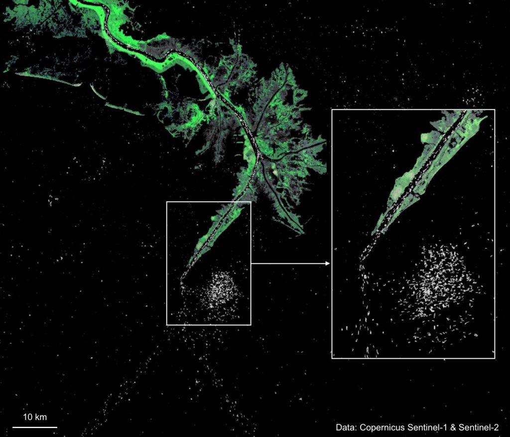
Mississippi River delta and the Gulf of Mexico. Land surface from Sentinel-2 false color composite B4/B8/B2 on 2019-04-03.

Notes
Ship detection using SAR imagery can be a bit more complex. In particular a challenge is to deal with interferences from ground sources and SAR ambiguities which create "ghost ships" [1,2,3].
However, mass processing of Sentinel-1 data accounting for this effect has been donefor maritime surveillance in the Mediterranean sea.
 
Map combining the worlds shipping lanes and the main roads on one map

If you are a GEE user and would like to play with these composites here is a quick-start script: https://code.earthengine.google.com/522465700ba56fadc5814ac457219d85).
The shipping lanes can also be visualized using Automatic Identification System (AIS) data (an automatic tracking system on ships) as done by Marine Traffic.
AIS data are emitted by all kind of ships (even small ships that may not be detected by Sentinel-1) and not only at 6am or 6pm.
However, an AIS tracker can be switched off, whereas the Sentinel-1 radar at 693 km above sea level is out of reach...
It seems that a Greek startup SatShipAI is building a tool to automatically identify ships using Sentinel-1 data.
A new challenge for the yellow vests?
Wikipedia article on Environmental impact of shipping: "The International Maritime Organization estimates that carbon dioxide emissions from shipping were equal to 2.2% of the global human-made emissions in 2012 and expects them to rise 50 to 250 percent by 2050 if no action is taken"
 
Links :

Wednesday, March 16, 2022

The Yemeni fishermen risking everything to feed their families

Yemeni fishermen moor their boat in Aden after fishing off the coast of Yemen's southern port city (AFP)
 
 
Hundreds of fishermen have been killed or injured at sea since the war began.
Those left are forced to sail further - and risk even more

Catching fish for a living in Yemen isn’t only about jumping in a boat and throwing a net into the sea. You need to also say goodbye to your family and prepare them for the fact that they might never see you again.

Because what was once a fairly routine occupation has, since war started in 2014, often become a matter of life and death.

This has little to do with storms or treacherous currents at sea, but rather the fact that after the Saudi-led coalition declared most of Yemen's territorial waters a conflict zone, fishermen have frequently been fired upon and killed when attempting to work there.

As of August 2019, at least 334 fishermen had been reported killed or injured since 2015, according to statistics from Yemen's fisheries authority.
Others had been arrested and had their boats seized, while some were now detained in Saudi-run prisons in Yemen.

'When we try to fish in deeper areas, where there are a lot of fish, Apache helicopters chase us and the fighters shoot at us'

- Ahmed Futaih, fisherman in Aden

“We are allowed to fish in specific areas near to the beach," Ahmed Futaih, a fisherman in his 40s from Aden city, told Middle East Eye.
"But when we try to fish in deeper areas, where there are a lot of fish, Apache helicopters chase us and the fighters shoot at us or their military boats arrest us and seize our boats.
"One of my colleagues was arrested by the Saudi-led coalition and they seized his boat. They only released him after he signed papers saying that he would not fish in the banned areas again.”

Local reports estimate that of Yemen's approximate 100,000 fishermen, since 2015 over a third (37,000) have quit and thus lost their income.

This in one of the world's poorest countries, where the war has resulted in tens of thousands of people living in famine-like conditions and which has been declared by the United Nations as the world’s worst humanitarian crisis.

Driven further out to sea


Desperate to continue earning a living and feeding their family, some fishermen, such as Futaih, have been forced to go out far beyond Yemen's territorial waters and head for Somalia, where there are plentiful fish stocks.

There they are safe from the coalition's bullets and punishment, but not from other hazards.

“Many fishermen decided not to continue in this dangerous job and they went to look for an alternative," Futaih told MEE.
"But I don’t have any other profession to help me to provide for my 11 family members.

“Now, I fish in the allowed Yemeni waters and sometimes I go to Somali waters. When Somali coastguards arrest us, they seize all our fish and take our boats and sometimes they shoot at us when we try to flee.”
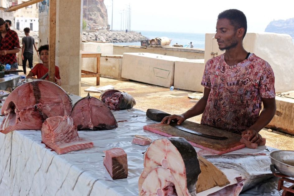
Yemeni fishermen sell their catch at a market amid spiralling prices, in the southern port city of Aden on 28 September 2021 (AFP)

Futaih said that the Yemeni fishermen had built a relationship with their Somali counterparts and that they sometimes worked together, dividing the catch between them.
The Somali fishermen often had sympathy for their Yemeni colleagues, he added.

“They can be helpful towards Yemeni fishermen and allow us to fish in Somalia's waters, but we need to pay fees,” Futaih said.
“But some of us can’t afford the fees, so we have to fish illegally”.

Futaih said that it costs them more time and fuel to sail to Somalia (whose nearest coastline is 200kms from Aden), but that apart from the costs, the main danger was being spotted by the Somali coastguard.

“When we try to flee from the Somali coastguards, they shoot at us but usually we manage to escape," Futaih told MEE.
"But if they do manage to arrest us, that usually means going to prison.”

In March 2021, a Somali court fined 3o Yemeni fishermen $700 each and seized their boats for illegally fishing in the East African country's territorial waters.
At the same time, the court released eight Yemeni children who had also been arrested on the seized boats.

'Otherwise I will starve to death'


Malik, a fisherman who inherited this job from his father, told MEE that while Yemen's waters may not be safe to fish in for Yemenis in small boats using traditional methods, large commercial fishing vessels from the Gulf states were trawling for fish every day.
“It isn’t safe for us who fish in the traditional way to fish in Yemen, but the Emirati and Saudi fishing vessels are allowed to dredge our fish from anywhere they want,” Malik said.

Malik was arrested by the Somali coastguard and released last year after they had seized his boat and he'd paid a fine to Somali authorities.
'Every day I go to sea, I tell my family that I might not return as the threats in the sea are great, either in Yemen or Djibouti or Somalia'
“I was fishing with other fishermen in the same boat and the Somali coastguard chased us and shot at us. We didn’t manage to flee so we surrendered to them,” Malik said.

Malik was sent to a Somali prison for a month and only released when he'd paid a fine.
“I don’t have a boat now, but I hire one and sail to fish in Yemeni waters or near Somalia's waters," Malik told MEE. 
"That’s my only choice, otherwise I will starve to death together with my wife and three children."

The Djibouti coastguard has also arrested Yemeni fishermen.
The last time was in November 2021, when the six fishermen from Aden were detained.

Desperate situation

Yasmin Mohammed, from Aden, told MEE that she used to cook fish every day in the family home.
It was such a staple in the family's diet that her children would sometimes ask her for a break from it.

“Fish used to be very cheap and most families in Aden could easily afford it. But since 2015 prices have been increasing and it is now unaffordable,” she said. 
“Fish that used to cost 1,000 ($4) Yemeni riyal now costs YR10,000 ($40).”

Yasmin, a widow providing for four children, said that she hardly buys fish anymore as only rich families can afford it.

The port city of Aden lies in the Gulf of Aden and many of its residents work as fishermen.
 

The fish they caught fed people far beyond Aden.

Saeed, a fisherman from Aden's waterfront Sira district, said that fish prices had risen dramatically because of the increasing dangers and challenges that Yemini fishermen now face.

“Fishermen have specific areas to fish in Yemeni waters where there are not enough fish and the fish aren’t the best kinds," he told MEE. 
"When they sail to Somalia or Djibouti or buy from African fishermen, that costs a lot, so fish in Aden isn’t as cheap as before.”

Saeed said that many fishermen had drowned as they headed directly into rough seas to avoid being chased by coastguards, either in Somalia or Yemen.

It is a desperate situation, which can only get worse as the war in Yemen enters its eighth year, with no sign that a resolution is near.
Meanwhile, Yemen's fishermen find themselves in an impossible situation.
“In Yemen, the coalition shoots at us and in Somalia, it is the coastguard," Malik told MEE.
"So we only have two choices, and they are both difficult.” 
 
Links :
Tuesday, March 15, 2022

After a US attack sub hit an underwater mountain, we look at what's happening on the ocean floor

 
The Seawolf-class fast-attack submarine USS Connecticut (SSN 22) departs Puget Sound Naval Shipyard for sea trials following a maintenance availability.
Photo: Thiep Van Nguyen / U.S. Navy
 
From FoxWeather by Aaron Barker
 
Water covers about 71% of the planet and oceans hold about 96% of that water, according to the United States Geological Survey.

Underneath all that water lies worlds unto their own – towering mountains, cavernous trenches and plains in between.
As it turns out, we don’t know as much about the underwater part of Earth as many would think.

The USS Connecticut, an attack submarine, ran into one of those mountains late last year in the South China Sea.
 
The USS Connecticut, which had its sonar dome damaged in a collision with an underwater seamount, pulls into Naval Base Kitsap-Bremerton 
Meegan M. Reid/Kitsap Sun
 
A satellite image shows the USS Connecticut nuclear submarine moored in Guam for receiving prelimanary repairs.
Photo: Weibo
 
The Navy Times reported last week that the sub's sonar dome and main ballast tanks were damaged. Navy officials said "adherence to required procedures in navigation planning" was one of the things that could have prevented the collision, according to USNI News.
 

Glen Rice, a physical scientist with NOAA’s Ocean Service and the Office of Coast Survey, said that he doesn't know why the Connecticut ran aground, but did say there is plenty about the ocean floor that we still don't know.
"There's a, you know, a common saying: We know more about the surface of Mars than we do about, you know, the deep ocean on our own planet," Rice said.
Rice is part of a team at NOAA whose job it is to develop maps of the sea floor and allow vessels to safely navigate the water.
He said there is a plethora of instruments scientists use to survey the ocean floor, such as sonar, lasers, airplanes and satellites.
It all depends on how much detail is desired and the depth of the ocean floor.
"You could also use satellite-derived imagery, which is using more like pictures, and you're using kind of how the light changes as it goes through the water," Rice said.
"As you move away from that really shallow-water environment or in places where it's murky, you really need to use sound a lot of the time because that penetrates much better."

What’s down there?

The tallest mountain on Earth actually has its start underwater.
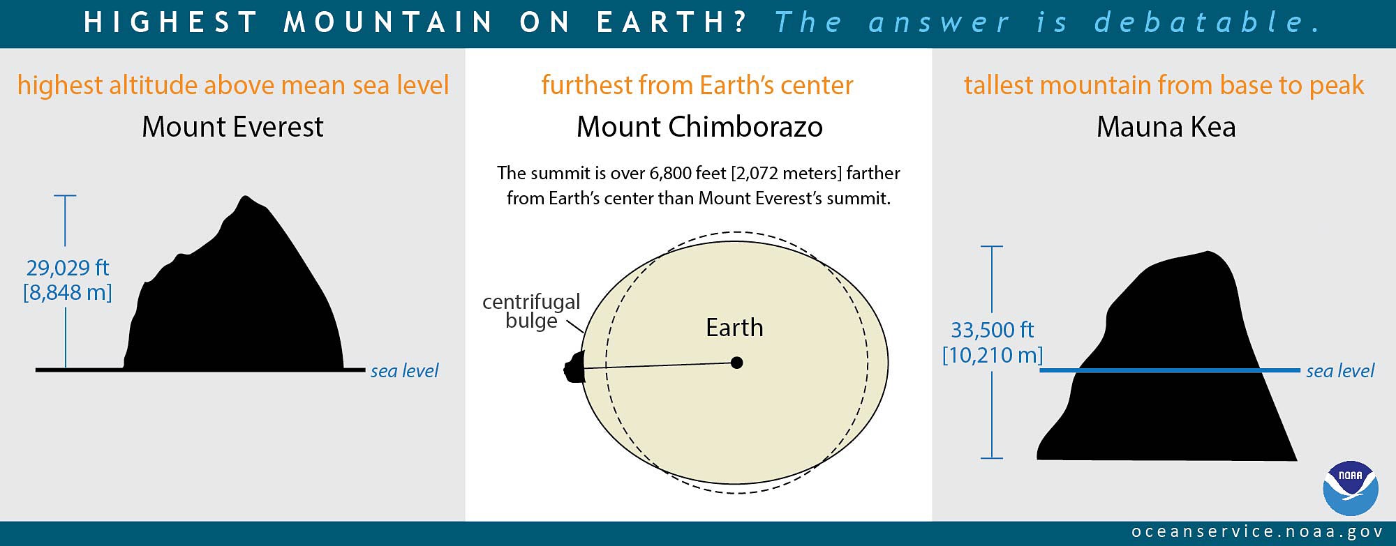
Mount Everest holds the title as the tallest mountain above sea-level at just more than 29,000 feet.
However, the tallest mountain on the planet is Mauna Kea, a volcano on the Big Island of Hawaii.
According to NOAA, Mauna Kea is 33,500 feet tall from its base on the floor of the Pacific Ocean.


Less surprising is the fact that the deepest point on the planet is in an underwater trench.
The Mariana Trench is a 1,500-mile long canyon, located in the Pacific Ocean east of the Philippines.
According to NOAA, it is 35,900 feet deep at its deepest point called Challenger Deep.
That’s nearly 7 miles.

The longest mountain range on Earth is also underwater.
The mid-ocean ridge system spans more than 40,000 miles across the globe, according to NOAA.

In between mountains and trenches, are seamounts, abyssal plains and hills, which lead to continental shelves – the shallowest parts of the ocean.
 
STRM bathymetry in South China Sea with the GeoGarage platform

What we don’t know

Alberto Neves, the hydrographic science program coordinator at the University of Southern Mississippi, said most of the ocean floor is unmapped.
"Well, there is an estimation that only 20% of the bottom of the oceans are surveyed, which means that we don't know about 80% of what's in there," Neves said.

Neves said there are various measurements of the ocean floor out there, but they don’t provide a complete picture of the bottom of the ocean.

"In general, when you look at the Google Maps and you see those beautiful features -- but in fact, some of them are estimated to exist or others we don't know."

Closing the map gap

Neves said there is an international project to remedy that problem called Seabed 2030.
Launched in 2017, the goal is to have 100% of the ocean floor mapped within the decade.

"It (has had) a lot of impact already," Neves said. "About four years ago, we had only 6% of the bottom of the ocean surveyed, and we are getting closer to 20% thanks to this international effort."

Some of the 20% that is mapped has some striking detail.
Rice said he is part of the team working on the National Bathymetric Source project, which aims to collect the best-available data to create high-resolution nautical charts.
"Where you have contours, are generally what you call them on topographic maps, we call them depth curves, I think traditionally on a chart," Rice said. 
"Then we tend to put a lot of soundings in there because, you know, that helps call out specific features."
Rice said the higher the resolution of a map, the better it can help not only vessels navigate the water but also policy makers better manage the resources that are there.

Links :

Monday, March 14, 2022

Russian-owned super yachts going dark to avoid sanction seizure

"Several yachts associated with Russian oligarchs have started atypical journeys. They appear to be headed to the Suez Canal. One example is Quantum Blue, a 104-meter (340 ft) yacht, reportedly owned by Sergey Galitsky, co-owner of Russia’s largest retailer." 
Graphic by H I Sutton used with permission
 
From USNI by H I Sutton

Mega-wealthy owners of the superyachts value privacy and discretion and keep as low a profile their vessels allow and recent events in Ukraine have increased the desire of some superyacht owners to hide their movements.

 
 @RussiaYachts, tracking Russia yachts Putin & Oligarchs
 
Yachts owned by Russia’s oligarchs may be subject to being seized under international sanctions. Several vessels have already been detained.
 
These include Amore Vero, reportedly owned by Igor Sechin, a former Russian administration official and CEO of the Rosneft energy company. Lady M, is reputedly owned by Alexei Mordashov, a steel and mining billionaire.

Some boats are going dark, turning off their automated identification systems and running to safe harbors.
Some are be sailing to remote Russian ports not normally associated with luxury yachts.

One such yacht is Amadea. This 106-meter (348 ft) yacht is reputed to be owned by Suleyman Kerimov, a Russia-based billionaire and politician, who is on the sanctions list.

Amadea stopped transmitting her position on AIS (Automated Information System) on Feb. 24, just hours after the start of the invasion.
AIS is required, under Safety Of Lives At Sea (SOLAS) rules. The International Maritime Organization’s rules require, “AIS should always be in operation when ships are underway or at anchor.”

An exception is allowed if the captain believes that the ship is under threat and that the AIS might compromise the safety or security of the vessel.
Even the captain must inform the relevant authorities that they are doing it and why.
Circumstantially, it appears that these yachts are turning it off as a deliberate attempt to avoid detection.


Graphic by H I Sutton used with permission

Amadea was reported as having arrived in English Harbour in Antigua by specialist channel eSysman Super Yachts.
Photographs and video, provided by anonymous contributors, showed the yacht there.
USNI News has been able to collaborate this with satellite imagery and other open sources.
The yacht arrived in its Caribbean hide-out on March 5 or 6 and is visible in satellite imagery provided to USNI News by ShadowBreak Intl.

Several other yachts associated with Russian oligarchs have also started atypical journeys.
Several appear to be headed to the Suez Canal.
One example is Quantum Blue, a 104-meter (340 ft) yacht, reportedly owned by Sergey Galitsky, co-owner of Russia’s largest retailer.

Quantum Blue had temporarily been detained in Monaco by Monegasques and French authorities on March 3.
However, Galitsky was not on the European Union sanctions list and the boat was released.
It sailed straight to Port Said, at the entrance to the Suez Canal.

Amadea has since left Antigua and remains ‘dark’ on AIS.
Her final destination is unclear –like the final destination of many of these yachts is subject to speculation.
An obvious destination in the Indian Ocean might be the Maldives or Seychelles where they are likely safe from the sanctions.
According to eSysman Superyachts, certain vessels may ultimately be headed to Vladivostok in the Russian Far East.
 
Links :

Sunday, March 13, 2022

Off by a Mile: Royal Navy fixes charted location of a Pacific Island

Photo of Henderson Island by Andrew MacDonald 
(rspb-images.com)
 

Sailors on a Royal Navy warship have proven a remote Pacific island has been in the "wrong place" for 85 years.
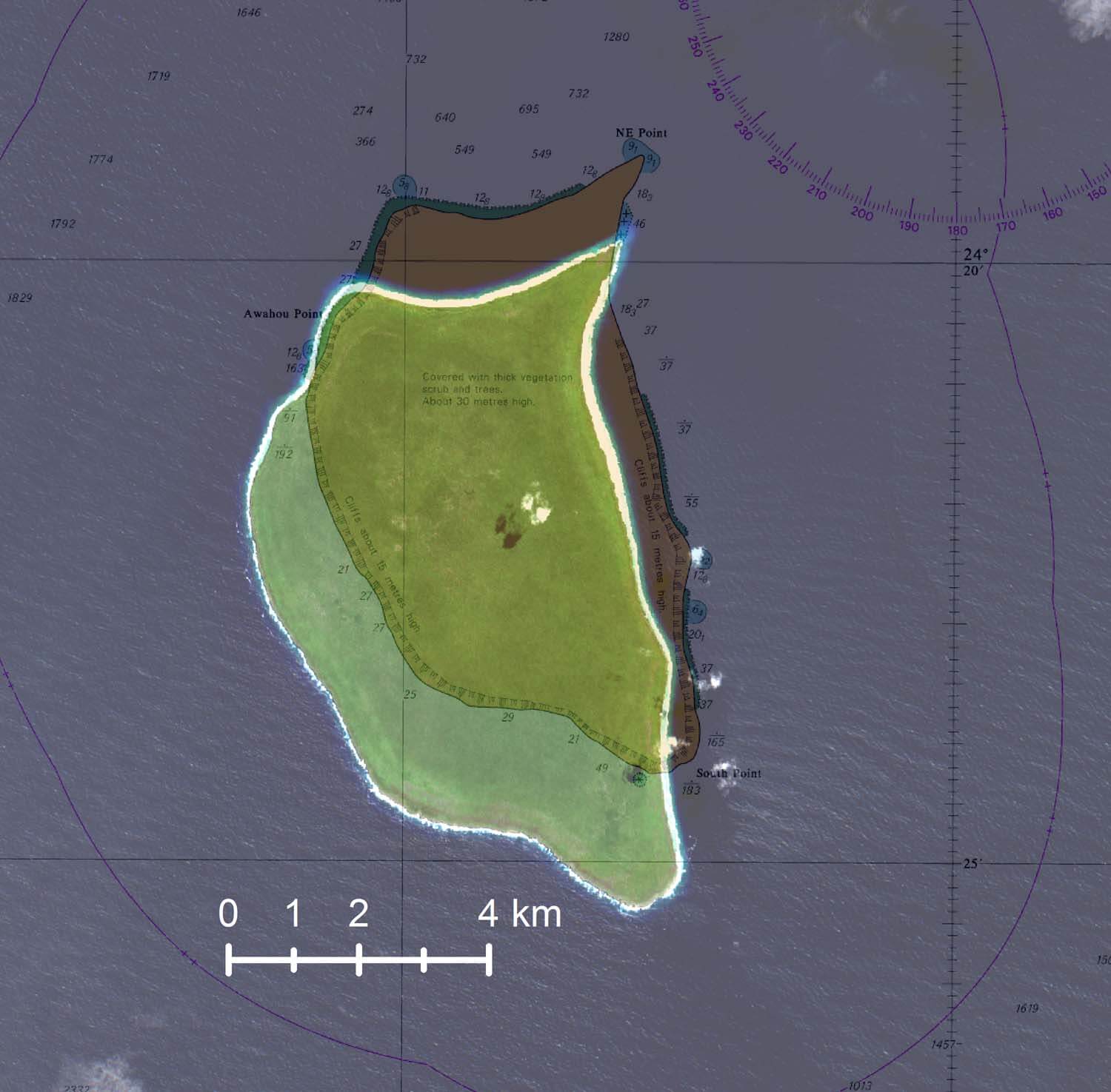
It turns out that Henderson Island in the South Pacific is one mile south of the position marked on nautical charts since 1937. 
 
Henderson island with the GeoGarage platform (UKHO nautical chart)
 
The Pitcairn Islands, officially the Pitcairn, is a group of four volcanic islands in the southern Pacific Ocean that form the sole British Overseas Territory in the Pacific Ocean.
The four islands—Pitcairn, Henderson, Ducie, and Oeno—are scattered across several hundred miles of ocean and have a combined land area of about 18 square miles (47 km2).
Henderson Island accounts for 86% of the land area, but only Pitcairn Island is inhabited.
Chile is 3,600 miles to the east and New Zealand 3,200 miles to the southwest.
see other map 

Uninhabited Henderson Island is one of four features in the remote Pitcairn chain.
Chile lies about 3,600 miles to the east and New Zealand 3,200 miles to the southwest.

Regularly-transited areas are well covered by up-to-date UK Hydrographic Office charts, but the Pitcairn chain is so remote that it has only had some satellite-based data collection in recent years.
The satellite data suggested that the island's position on historical charts was inaccurate, so HMS Spey offered to assist with data gathering.


Spey is not a dedicated survey vessel, but navigator Lieutenant Michael Royle used radar imagery and GPS data to conduct a simple check of the island's position, overlaying the details on the existing charts of the Pitcairn chain.

“In theory, the image returned by the radar should sit exactly over the charted feature – in this case, Henderson Island,” Lieutenant Royle said. 
“I found that wasn’t the case – the radar overlay was a mile away from the island, which means that the island was plotted in the incorrect position when the chart was first produced. The notes on the chart say that it was produced in 1937 from aerial photography, which implies that the aircraft which took the photos was slightly off in its navigational calculations.”
 
 Henderson island with the GeoGarage platform (NGA)
 
Henderson island with the GeoGarage platform (UKHO)


The work by Spey is part of a wider British program to update maritime charts of waters around the UK’s Overseas Territories and improve navigation.
 
 
The program uses sonar, airborne laser techniques and satellites to better understand, manage and protect the marine estates of these territories.
 
Ducie island (also with the GeoGarage platform (NGA)
It lies east of Pitcairn Island, and east of Henderson Island 
-- an other example of shifted map --
 
Ducie island with the GeoGarage platform (UKHO)
 

Note : Pitcairn and Oeno islands UKHO maps are well positionned
 
Admiralty Chart No 1113 Pitcairn Island, Published 1829
 
Henderson Island is perhaps known best for its least glamorous feature.
 

Pacific currents carry large volumes of floating debris to the island, and as many as 40 million items of plastic and rubbish litter Henderson’s beaches, and it has been dubbed the "most polluted island in the world."
 
 
HMS Spey also collected water samples near the island to help scientists learn more about the remote area.++
“Scientists in the UK have really scant data about the ocean in this region – its salinity, temperature, water pressure and the like,” Lt Royle added.
“They are keen to understand climate change in the area.”
 
Links :

Free to dive - A discovery journey into apnea


Human and water. A relationship that dates back to our origins.
Immersed for 9 months, already at our birth we have the reflexes of apnea. But what toddlers can achieve- others, much older are incapable of doing.
Sam is aquaphobic and is about to face a gigantic challenge, as in 3 months she’s departing to Philippines in order to learn freediving.
Followed by Janosh (scuba diver), Lucie (yoga practitioner) and Remy (surfer) - 3 other beginner divers with whom she’ll learn the foundations of this incredible sport.
But will they succeed ?
Descending 10 or 15 meters deep when you are afraid of water seems rather impossible.
Through different portraits we will question the human relationship with water, while discovering that freediving is much more accessible than we imagined.
An internal journey which will push each of the participants to pass their limits and to reconquer their element of origin.

Links :