Saturday, June 27, 2020
Coexistence
Below the surface of the oceans, a sheer diversity of creatures dwell in harmony - mantas fly, sharks flash by, fish twirl around vibrant reefs.
It’s a dance that they have been dancing for millions of years.
A cosmic symphony.
A story of coexistence.
We must learn from it and come together to protect the future of our blue planet.
It all started in the middle of the Pacific Ocean, on the island of Moorea.
Here, coral reefs shape our lives below and above the surface of the ocean.
We owe them everything: from every single wave we surf to every bite of food we eat and every breath of air we take.
Today, we are on the edge of losing an entire ecosystem.
Coral reefs, as bountiful and beautiful as we have once known them, are going extinct.
But every edge leads to a new beginning.
Join us to save them and spread the word about this crisis that affects all of us.
Three years ago, we created our own movement, today we start changing history.
Although it may appear a big endeavor, it can all start by fixing one broken coral.
Adopt corals on our website
Friday, June 26, 2020
Sea of troubles : Covid-19 has led to a pandemic of plastic pollution
As the world produces more protective equipment—and gorges on takeaways—pity the ocean
From The Economist
The Thames has always been a reflector of the times, says Lara Maiklem, a London “mudlark”.
Ms Maiklem spends her days on the river’s foreshore foraging for history’s detritus, from Roman pottery to Victorian clay pipes.
She can tell the time of year, she says, just by the type of rubbish she has to sift through: champagne bottles during the first week of January; footballs in summer.
The year 2020 has left its own mark.
Since the coronavirus reached Britain the mud has sprouted a crop of latex gloves.
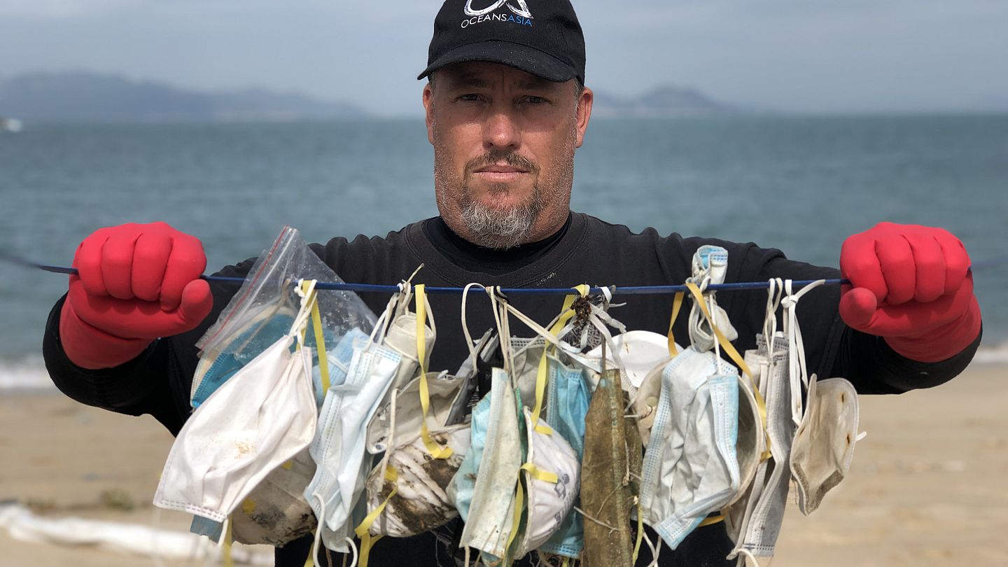
In February, half a world away, Gary Stokes docked his boat on Hong Kong’s isolated Soko Island.
Soko’s beaches are where OceansAsia, the conservation organisation he runs, sporadically records levels of plastic pollution.
Mr Stokes says he is all too accustomed to finding the jetsam the modern world throws up, such as plastic drinks bottles and supermarket carrier-bags.
But what he documented that day made news across Hong Kong: 70 surgical facemasks on a 100-metre stretch of beach.
Having cleaned it up, he went back four days later.
Like a stubborn weed, the masks had returned.
Whether on the foreshore of the Thames or the deserted beaches of Soko, the planet is awash with pandemic plastic.
Data are hard to come by but, for example, consumption of single-use plastic may have grown by 250-300% in America since the coronavirus took hold, says Antonis Mavropoulos of the International Solid Waste Association (ISWA), which represents recycling bodies in 102 countries.
Much of that increase is down to demand for products designed to keep covid-19 at bay, including masks, visors and gloves.
According to a forecast from Grand View Research, the global disposable-mask market will grow from an estimated $800m in 2019 to $166bn in 2020.
Staggering though such figures are, personal protection is only part of the story.
Lockdowns have also led to a boom in e-commerce.
In March, as parts of America and Europe shut up shop, some 2.5bn customers are reckoned to have visited Amazon’s website, a 65% increase on last year.
In China, more than 25% of physical goods were bought online during the first quarter of the year, according to the Peterson Institute for International Economics, a think-tank in Washington, DC.
Much of what is bought online comes wrapped in plastic—and the bad kind at that.
Goods are often packaged in plastic comprising several layers.
That keeps the contents safe in aeroplane holds and on delivery lorries.
It also makes it nearly impossible to recycle the plastic.
At the same time, the locked-down masses have been consuming home deliveries from restaurants in record numbers.
First-quarter sales at Uber Eats, one of America’s biggest restaurant-delivery apps, for example, rose by 54% year on year.
Every extra portion of curry, or pot of garlic dip, means more plastic waste.
If the public’s increasing appetite for single-use plastic worries environmentalists, then so too does its diminishing inclination to recycle materials that can be reused.
In Athens, for example, there has been a 150% increase in the amount of plastic found in the general-waste stream, says Mr Mavropoulos.
Anecdotal evidence from ISWA members suggests this is a worldwide trend.
An unwillingness to recycle might be explained by people’s nervousness about venturing out to put waste in recycling bins.
Or it might just be that lockdowns have put more pressing matters into their minds, prompting a slip in their diligence.
"opération mer propre"
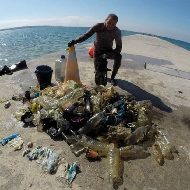
Coronavirus masks and gloves found with a mass of plastic at Golfe-Juan
Covid-19 has led to a glut in plastic waste in other ways.
For one, the pandemic caused a crash in the oil price.
Because petroleum is a major constituent of most plastics, they became cheaper to produce, says David Xi of the University of Warwick.
That in turn gave firms less incentive to use the recycled stuff.
But the growth of plastic rubbish is mainly caused by the fact that municipalities around the world have curtailed their recycling schemes.
Collections have been cut back and plants have been shut over fears about spreading the contagion.
Worries about contaminated rubbish have also made some refuse collectors and sorters nervous about going into work (the virus can survive for about 72 hours on plastic).
All of which means that much of the plastic produced this year is ending up either in landfill sites or being incinerated.
Both could store up future problems.
Landfills, especially in poor countries, are often little more than open dumps.
They are responsible for some of the biggest leakages of plastics into oceans, says Mr Mavropoulos.
Because the material is light, it is easily swept by rain or wind into waterways.
Incineration is not much better.
Again, particularly in the developing world where facilities can be shoddy, not only can burning plastics create toxins, but it also often fails to obliterate the plastic, leaving considerable levels of nano- and micro-particles.
These can both be emitted into the atmosphere, where they can cause cancers, or leach into groundwater and eventually into oceans.
There is no academic consensus on whether plastics in the oceans, once they are broken down by salt and sun into micro-particles, are particularly dangerous to animals.
Polymers, on which plastics are based, are chemically inert, although some additives can be toxic.
But given the huge natural experiment now under way, researchers may soon have a clearer idea.
“We are only just starting to understand the potential impacts of nanoparticles and the way in which they can penetrate into living cells in marine organisms as well,” says Dan Parsons, director of the Energy and Environment Institute at the University of Hull.
“Plastic nanomaterials released into the environment could be the asbestos of the seas.”
Indeed, like the virus itself, pandemic-era plastic pollution is hitting the poor hardest, says Inger Andersen, executive director of the United Nations Environment Programme.
In low-income countries, 93% of waste goes into open dumps, she says.
And where there are incinerators, they tend to be of low quality.
Even in rich countries, the poor are more likely to live closer to facilities that deal with rubbish, says Ms Andersen.
There are good reasons why the public has turned to plastics, says Mr Parsons: “People know that it protects them” from the coronavirus.
Not only that, points out Ms Andersen, it is hardly fair to blame manufacturers for producing environmentally unfriendly protective equipment—or consumers for buying it—given the global scramble to obtain the materials needed to make the masks and visors that keep health workers and others safe.
And a world in which less plastic is produced would not necessarily be a greener one.
Because the material is light, it often causes lower emissions when it is transported than alternatives do.
But what worries Mr Parsons is that years spent trying to change the public’s attitude towards single-use plastic might now be lost.
Preliminary findings from research his team has conducted suggest that the public has reverted to its earlier insouciance about plastic waste.
The pandemic has already encouraged the rolling back of anti-plastic legislation, such as taxes on single-use grocery bags in some American states, or a ban on plastic straws in Britain.
Ironically, that may even help the climate.
But just as covid-19 has scarred families and harmed livelihoods across the world, its effect on the planet will linger, too, in the world’s landfills and oceans.
Links :
Thursday, June 25, 2020
New maps give most detailed look yet at mostly undersea continent of Zealandia
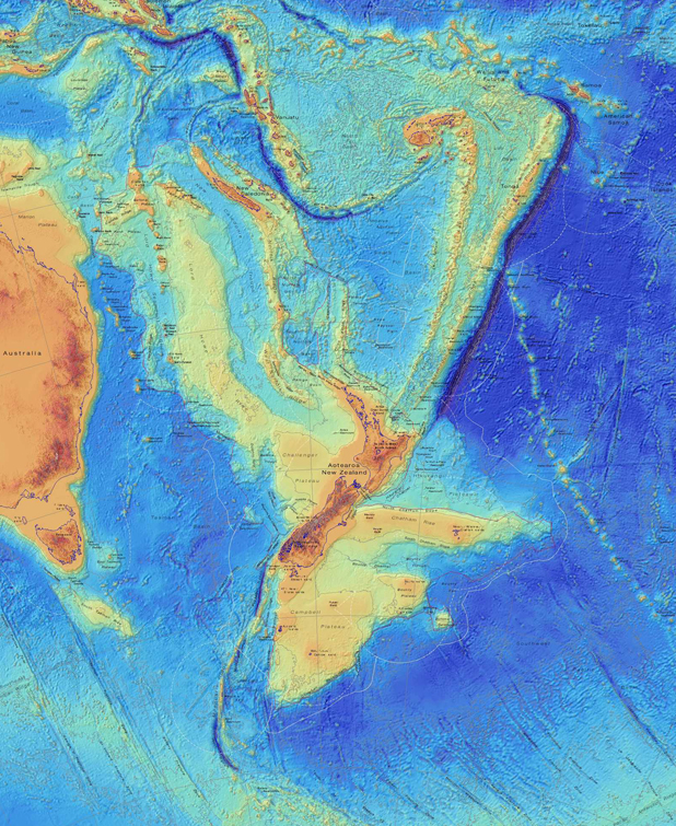
The new map showing the continent of Zealandia in more detail than ever before.
From Stuff
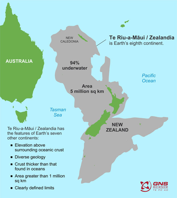
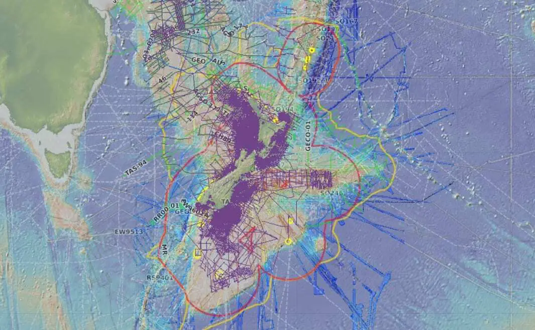
GNS Science has published the most detailed maps yet of the 95 per cent undersea continent of Te Riu-a-Māui/Zealandia.
New Zealand is the main part of the 5 million square kilometre continent above sea level, with New Caledonia being the other.
GNS has also launched a website called E Tūhura - Explore Zealandia, where the maps can be bought and which provides information about Zealandia.
The most detailed maps of Zealandia to date – incorporating all five million square kilometres (two million sq miles) of this underwater region and its geology
The website includes a brief history of Zealandia, explaining it was once part of the southern supercontinent of Gondwana, along with Australia, Antarctica, South America, Africa and India.
About 150 million years ago Gondwana started to break up, and about 100m years ago the Zealandia part started to "stretch like pizza dough".
Explaining why Zealandia should be considered a continent, the E Tūhura website said: "like all continents, Zealandia has high elevation compared with surrounding oceanic crust, rocks such as granite, schist and greywacke, relatively thick and low-velocity crust, and large size."
Bathymetric maps of Zealandia (GNS)
The map above shows the bathymetry of Zealandia – in other words, the shape of the ocean floor.
The highest parts of Zealandia are the orange-coloured areas of New Zealand and New Caledonia. They are surrounded by continental shelves (yellows). The blue areas are deeper basins of oceanic crust.
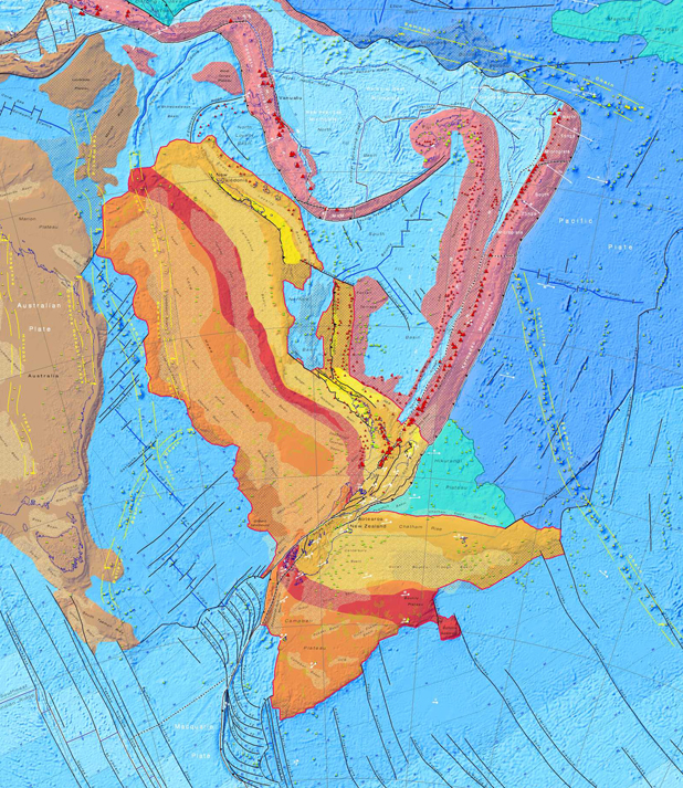
Tectonic map of Zealandia (GNS)
The second map shows the types of crust that make up Zealandia and its main tectonic feature.
An explanation of the map said that asdid the other continents, Zealandia had a foundation of old, hard, crystalline rocks and a cargo of younger sedimentary basins and volcanoes.
“We’ve made these maps to provide an accurate, complete and up-to-date picture of the geology of the New Zealand and southwest Pacific area – better than we have had before," GNS geologist Dr Nick Mortimer, the lead author of the maps, said.
They provided a fresh context in which to explain and understand the setting of New Zealand's volcanoes, plate boundary and sedimentary basins.
Links :
- Stuff : White Island/Whakaari: Health and Safety laws waived for eruption rescue to take place / Sunken continent Zealandia used to be closer to the surface, with a very different climate / Scientists explore the hidden continent of Zealandia / Scientists to drill into Zealandia, the lost continent beneath New Zealand / New Zealand actually sits on a continent called Zealandia, it's just that most of it is under water
- CNN : Maps reveal new details about New Zealand's lost underwater ...
- GeoGarage blog : We thought New Zealand was an island nation. Scientists ... / The missing continent it took 375 years to find
Wednesday, June 24, 2020
China completes BDS navigation system, reduces reliance on GPS
Photo: Hu Xujie
From Global Times by Deng Xiaoci
Navigation, positioning network reduces China’s reliance on GPS
"Ten, nine, eight…three, two, one. Launch."
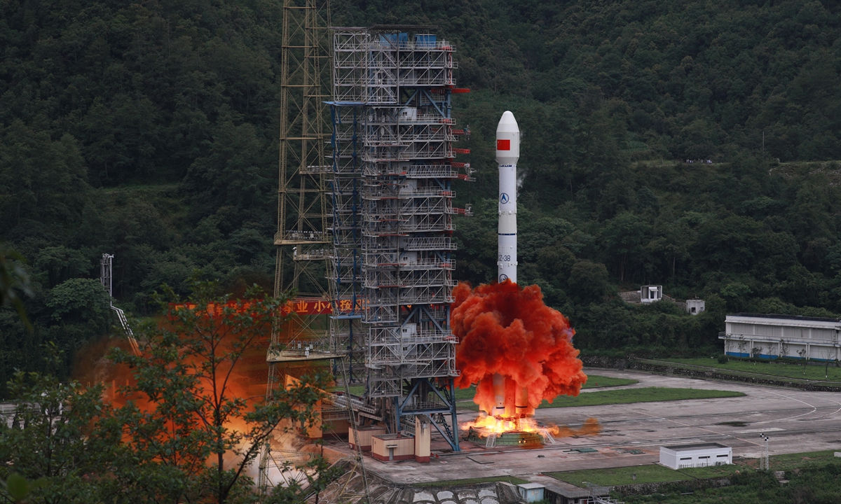
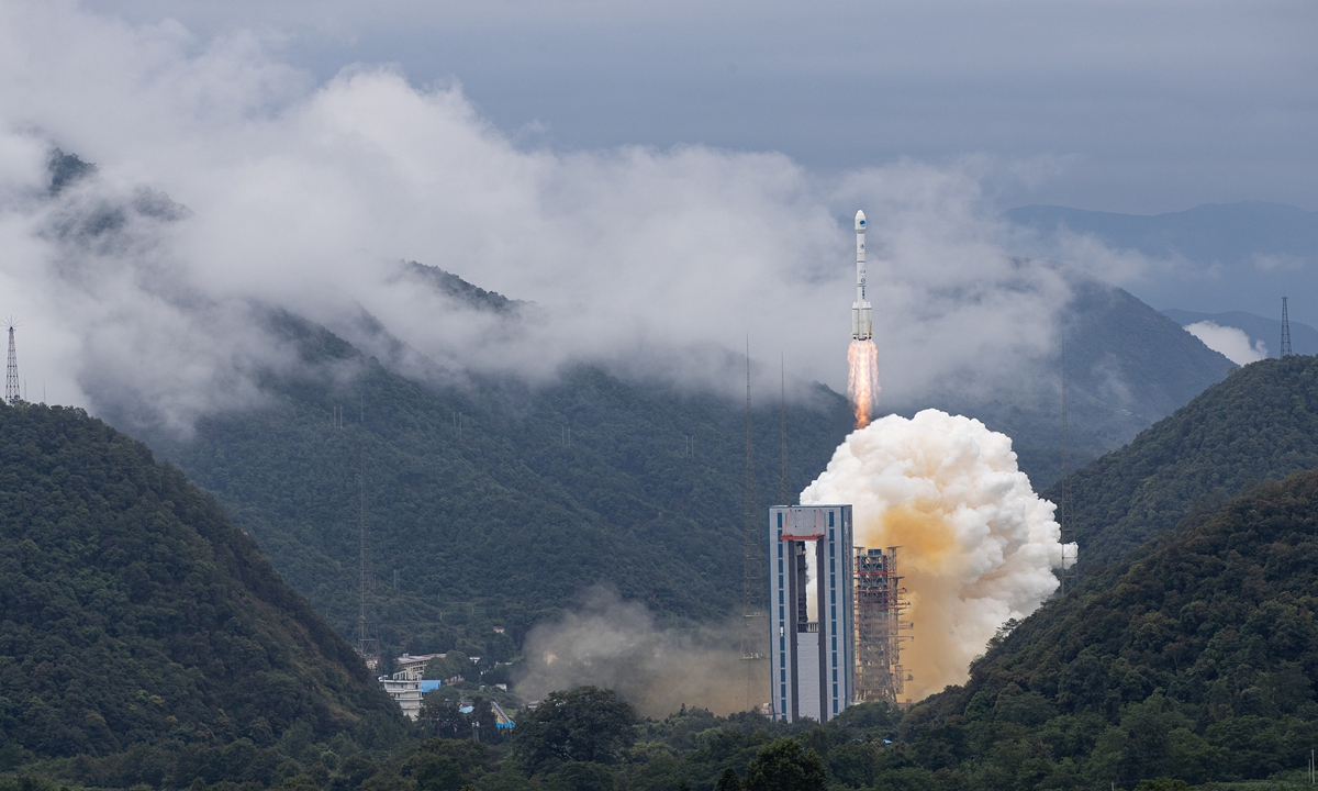
The calm voice of 01 Commander Yin Xiangyuan in the Liangshan mountain valley in Southwest China's Sichuan Province was soon overwhelmed by the thunderous boom of the rocket launch on Tuesday.
Carrying the last satellite of China's domestically developed BeiDou Navigation Satellite System, or BDS, the Long March-3B launch vehicle blasted off from the Xichang Satellite Launch Center Tuesday morning.
After being in flight for around half an hour, the spacecraft, the third geostationary Earth orbit (GEO) satellite and 30th of the third-generation series of the BeiDou system, or BDS-3, successfully entered its planned orbit, marking the completion of the global geolocation network, which is also China's largest space-based system and one of the four global navigation networks.
The three others are the US' GPS, Russia's GLONASS and the European Galileo.
The launch of the final satellite of China's indigenous BeiDou system was previously scheduled for June 16, but was delayed after technical problems were found with the Long March-3B rocket in pre-launch tests.
Space launches have always been full of challenges, and sometimes faced high risks of failure.
The postponement of the final BeiDou launch and resumption after resolving the problems once again shows that Chinese space scientists uphold the scientific spirit, allowing zero errors at any stage of the mission, insiders said.
Photo: Courtesy of CALT
World-class performance
The latest GEO satellite is the 55th BDS system, and will work with other members of the network, allowing global users to access high-accuracy navigation, positioning and timing, as well as communication services.
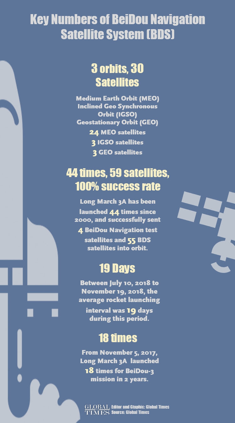
Compared to previous generation series, the constellation of BDS-3 with an array of 30 satellites on three different orbit planes - three at the GEO, three at the inclined geosynchronous orbits, and 24 at the medium Earth orbit--have a higher bandwidth, enabling enhanced communication capability and carrying more accurate and stable atomic clocks to improve the precision of timing and navigation services, according to the project contractor, China Academy of Space Technology, under the state owned space giant China Aerospace Science and Technology Corporation (CASC).
The BDS-3 also possesses better messaging capabilities, increasing its unique short message service capacity from 120 Chinese characters to 1,200 per message, and the higher communication bandwidth also expands the number of users from 500,000 to 5 million.
BDS-3 is also capable of providing precise point positioning services (PPP) with a decimeter-level dynamic accuracy and centimeter-level static accuracy--meaning, it can support applications such as auto-pilot for vehicles and precision docking of ships.
Yang Changfeng, the chief architect of the BDS, told the Global Times on Monday that China's BDS is compatible with the US' GPS, Russia's GLONASS and Europe's Galileo, and users worldwide can freely choose from the four systems with the best signal from the global navigation satellite systems with over 100 satellites.
The chief architect said the BDS has satellites on three orbit planes in the Asia-Pacific region, which makes it more capable of resisting disturbances from occlusion, even in such environments with multi-layer surfaces in urban areas and in forests.
Users in low latitude areas in the Asia-Pacific region can enjoy non-stop navigation services from the BDS under these circumstances, and the accuracy of the BDS service is just as good as that of the US' GPS, and of world-class quality globally, Yang noted.
Yang also told media on Tuesday that the completion of the BDS-3 constellation marks a step forward in China's advance to space power.
The mission will complete the BDS-3 system, which, according to Wu Di, a scholar at the satellite positioning technology center of Wuhan University in Central China's Hubei Province, will further enhance the quality of services of the system for global users, with more satellites above every corner around the world, which will bring stronger signals.
The China Satellite Navigation Office on Tuesday said much of the world have started using the BDS.
The office told the Global Times in a Tuesday statement that the United Nation Office for Outer Space Affairs sent a special video to extend congratulations for the successful launch, and also spoke highly of the BeiDou system's contribution to the world's social and economic development.
Carrying the last satellite of China's domestically developed BeiDou Navigation Satellite System, or BDS, the Long March-3B launch vehicle blasts off from the Xichang Satellite Launch Center on Tuesday morning.
Photo: VCG
Key strategic assets
People's Daily on Tuesday released a special video to illustrate why China has chosen to develop such an indigenous system when the US GPS is already in place and corners most of the civilian market.
The answer it offered was that while Chinese users have been benefiting from the GPS, the US system is not ours, and the video pointed out that GPS signals were developed by the US Air Force in the 1970s.
And owning our own indigenous navigation satellite system is the best way to resist being controlled by others.
"The manipulation of the US signals would paralyze any weapons solely relying on the GPS, which would lead to unbearable outcomes," the video stressed.
The US GPS and Russia's GLONASS were primarily designed for military use with civilian use as a by-product, Song Zhongping, a military expert and TV commentator, told the Global Times on Tuesday.
In military conflicts, having such key strategic assets would make a huge difference, Song noted.
For example, the high accuracy BDS navigation could guide the launch of missiles, and combatants could use the precision timing service BDS offers to effectively coordinate, the military expert said.
Infographic: GT
Infographic: GT
Hard work of generations
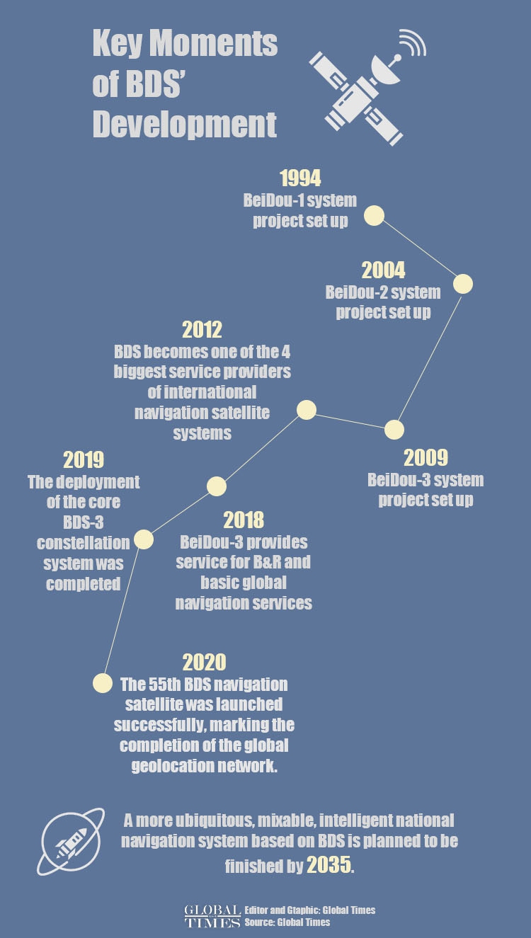
China began researching and developing the country's indigenous satellite system in 1994 to reduce its reliance on foreign networks, especially under the complicated external environment.
The first BeiDou satellite entered orbit in 2000, and started providing positioning, navigation, timing and messaging services to users in China and in the Asia-Pacific region in December 2012.
The BDS system started providing global services at the end of 2018, when construction of the BDS-3 primary system was completed.
BeiDou has been supporting dozens of businesses and public sectors in China, ranging from transportation and agriculture to electric power transmission and fisheries, and hundreds of millions of BeiDou-enabled terminal devices have been sold and are in use.
In the field of transportation, BDS has been widely used in monitoring and managing priority transportation, highway infrastructure safety, port scheduling, and real-time high-precision positioning.
By the end of 2019, in Chinese mainland, more than 6.5 million road operating vehicles, 40,000 postal and express delivery vehicles, 80,000 buses in 36 central cities, 3,200 inland navigation facilities, and 2,900 marine navigation facilities have adopted BDS, forming the world's largest dynamic monitoring system for road operating vehicles.
More than 70,000 fisheries and law-enforcement vessels have installed BeiDou terminals and more than 10,000 people have been rescued, thanks to the BeiDou application.
Time reference for public security networks has been synchronized based on the BDS timing services.
BDS has played an important role in ensuring security at major events, such as the Asia-Pacific Economic Cooperation (APEC) Meeting and the G20 Summit.
In the field of smart phones, mainstream chip manufacturers both at home and abroad have introduced integrated chips compatible with BDS.
By the third quarter of 2019, more than 400 smartphone models sold in China supported positioning functions, of which about 300 models supported BDS.
The scale of navigation satellite positioning and the navigation industry in China reached 345 billion yuan ($48.6 billion) by 2019, up 14.4 percent from the previous year, according to an annual industry report.
Cao Chong, a Beijing-based senior expert on the satellite navigation industry, told the Global Times the industry scale is expected to exceed 400 billion by the end of 2020.
Cao said the next step to further promote the BDS system in the market at home and abroad lies in the research and development of terminal capabilities, which should keep up with the enhanced power of BDS-3.
"There are huge market potentials."
The Tuesday mission marked the 44th BeiDou satellite-launching flight for the Long March-3A rocket series since October 31, 2000, of which the Long March-3B rocket belongs to.
The rockets have sent 59 BeiDou satellites, including four experimental ones, into orbit, with a 100 percent success rate.
As the BDS system continues to develop, the Long March-3A rocket series has also started to use three-mode receptors compatible with the BDS, GPS and GLONASS networks, Jiang Jie, the chief engineer of the rocket series, with the China Academy of Launch Vehicle, also under the CASC, told the Global Times.
As the three modes all complement each other, they work together to improve the orbiting accuracy of rockets and reduce the consumption of propellants, Jiang noted.
Links :
- The Guardian : China launches final satellite in Beidou navigation system to rival GPS
- BBC : BeiDou: China launches final satellite in challenge to GPS
- DailyMail : China completes its GPS-rivalling global navigation system Beidou six months ahead of schedule with the launch of the final satellite in its £7billion constellation
- National Defense : Viewpoint : Answering the Call for Greater GPS Resiliency
- Maritime Executive : Study: More than satnav is needed for safe navigation
- GeoGarage blog : China switches on BeiDou Compass 'BDS ...
Tuesday, June 23, 2020
Spanish retrieve lost treasure from wreck of Nuestra Señora de las Mercedes
Cannon and bullion have been recovered from the Nuestra Señora de las Mercedes, sunk by the British off Portugal in 1804
From The Times by Isambard Wilkinson
Spain has recovered hundreds of artefacts from the wreck of an early 19th-century ship that was sunk by the British and looted by treasure hunters.
The riches of the Nuestra Señora de las Mercedes, which went down in a battle off Portugal’s Cape St Mary in 1804, were raised in an American court after a US salvage company took 594,000 gold and silver coins worth £308 million from the site in 2007.
Spain regained the 14-tonne hoard in 2012 and began another investigation of the wreck.
An archaeological report published recently said that a second trove of treasure had been found with anchors, iron and bronze cannon, copper and tin ingots, silver cutlery and chandeliers, a gold mortar and pestle and a huge amount of copper bullion.
Iván Negueruela, the director of Spain’s National Museum of Underwater Archaeology, said: “The finds are of inestimable scientific and historic value.”
The museum will exhibit the relics in November.
The shipwreck is approximatively located off the Southern Coast of Portugal, opposite Faro at a distance of 34 Nm
Position at a depth 1131-1138 m
The vessel was sunk in dubious circumstances that eventually led to Spain joining the Napoleonic Wars against Britain.
When the 1802 Treaty of Amiens broke down after barely a year, Britain declared war on France.
An uneasy peace existed with Spain.
On hearing that Spain was transporting tonnes of coins minted in Lima, Peru, Britain sent a squadron to intercept the ships.
The flotilla was attacked a day’s sailing from Cadiz. Within five minutes a cannonball hit the gunpowder magazine of the Mercedes, which was carrying state and private money.
The ship exploded, killing more than 275 people, including women and children returning to Spain. The British captured the rest of the Spanish frigates, which were taken to Plymouth.
In 2007 some of the cargo was retrieved by the Odyssey Marine Exploration company, which had it flown to Tampa, Florida. (see Black Swan project)
A court in 2012, however, forced the treasure hunters to return the haul to Spain.
The latest excavations worked at a depth of more than 1,100m in international waters, 30 nautical miles off Portugal.
The items found had been listed in the ship’s manifest, including cutlery inscribed with a passenger’s name.
The report said: “Mention should be made of the perfection with which the documentary sources coincide with archaeological evidence in this case.”
Links :
- El Pais : Spanish archaeologists recover new treasure from famed ‘Mercedes’ shipwreck / Shipwrecks of the Caribbean: Spain drafts treasure map of its own days of empire
- BBC : True-life treasure hunt that turned into a comic book
- The Guardian : Spain and Mexico renew search for 17th-century treasure galleon
- Ministerio de Cultura y Deporte - España : The shipwreck Nuestra Señora de las Mercedes. Exploration and excavation campaign, September 2016
- GeoGarage blog : Book review: ‘Oceans Odyssey’
Monday, June 22, 2020
One-fifth of Earth's ocean floor is now mapped
Seabed 2030 web app
From BBC by Jonathan Amos
We've just become a little less ignorant about Planet Earth.
The initiative that seeks to galvanise the creation of a full map of the ocean floor says one-fifth of this task has now been completed.
When the Nippon Foundation-GEBCO Seabed 2030 Project was launched in 2017, only 6% of the global ocean bottom had been surveyed to what might be called modern standards.
That number now stands at 19%, up from 15% in just the last year.
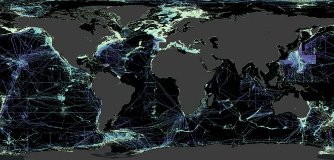
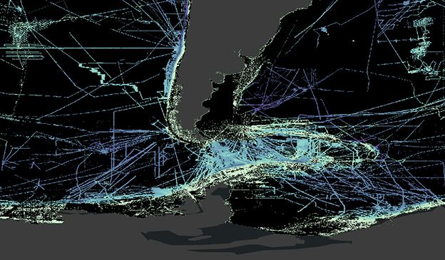
The black is where we still need modern measurements at a reasonable resolution
Some 14.5 million sq km of new bathymetric (depth) data was included in the GEBCO grid in 2019 - an area equivalent to almost twice that of Australia.
It does, however, still leave a great swathe of the planet unmapped to an acceptable degree.
"Today we stand at the 19% level.
That means we've got another 81% of the oceans still to survey, still to map.
That's an area about twice the size of Mars that we have to capture in the next decade," project director Jamie McMichael-Phillips told BBC News.
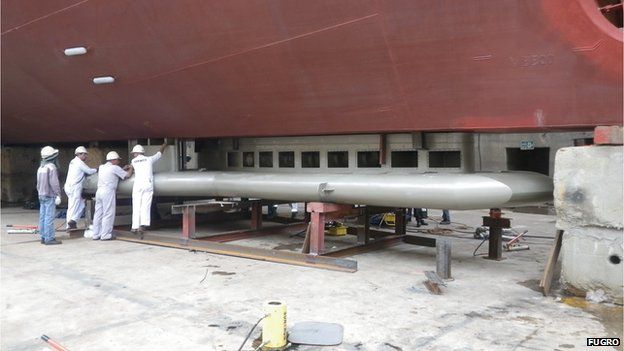
A state-of-the-art multibeam echosounder is slung below a survey ship
FUGRO ©
FUGRO ©
The map at the top of this page illustrates the challenge faced by GEBCO in the coming years.
Black represents those areas where we have yet to get direct echosounding measurements of the shape of the ocean floor.
Blues correspond to water depth (deeper is purple, shallower is lighter blue).
It's not true to say we have no idea of what's in the black zones; satellites have actually taught us a great deal.
Certain spacecraft carry altimeter instruments that can infer seafloor topography from the way its gravity sculpts the water surface above - but this only gives a best resolution at over a kilometre, and Seabed 2030 has a desire for a resolution of at least 100m everywhere.
Whilst the primary purpose of hydrography remains the production of
navigational charts, the role of hydrographers is changing fast.
Watch the video to find out about the innovative technology Fugro is developing that will ensure the global hydrographic community is positioned to play a more efficient, effective and important role in managing the marine environment and resources for a liveable world.
They are essential for navigation, of course, and for laying underwater cables and pipelines.Watch the video to find out about the innovative technology Fugro is developing that will ensure the global hydrographic community is positioned to play a more efficient, effective and important role in managing the marine environment and resources for a liveable world.
Better seafloor maps are needed for a host of reasons.
They are also important for fisheries management and conservation, because it is around the underwater mountains that wildlife tends to congregate.
Each seamount is a biodiversity hotspot.
In addition, the rugged seafloor influences the behaviour of ocean currents and the vertical mixing of water.
This is information required to improve the models that forecast future climate change - because it is the oceans that play a critical role in moving heat around the planet.
And if you want to understand precisely how sea-levels will rise in different parts of the world, good ocean-floor maps are a must.
Much of the data that's been imported into the GEBCO grid recently has been in existence for some time but was "sitting on a shelf" out of the public domain.
The companies, institutions and governments that were holding this information have now handed it over - and there is probably a lot more of this hidden resource still to be released.
The Mariana Trench in the Pacific is the deepest ocean location on Earth - but very well mapped

But new acquisitions will also be required.
Some of these will come from a great crowdsourcing effort - from ships, big and small, routinely operating their echo-sounding equipment as they transit the globe.
Even small vessels - fishing boats and yachts - can play their part by attaching data-loggers to their sonar and navigation equipment.
One very effective strategy is evidenced by the British Antarctic Survey (BAS), which operates in the more remote parts of the globe - and that is simply to mix up the routes taken by ships.
"Very early on we adopted the ethos that data should be collected on passage - on the way to where we were going, not just at the site of interest," explained BAS scientist Dr Rob Larter.
"A beautiful example of this is the recent bathymetric map of the Drake Passage area (between South America and Antarctica).
A lot of that was acquired by different research projects as they fanned out and moved back and forth to the places they were going."
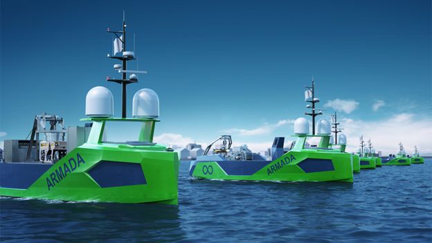
Artwork: Robot vessels can help close the gaps
Ocean Infinity ©
New technology will be absolutely central to the GEBCO quest.
Ocean Infinity, a prominent UK-US company that conducts seafloor surveys, is currently building a fleet of robotic surface vessels through a subsidiary it calls Armada.
This start-up's MD, Dan Hook, says low-cost, uncrewed vehicles may be the only way to close some of the gaps in the more out-of-the-way locations in the 2030 grid.
He told BBC News: "When you look at the the mapping of the seabed in areas closer to shore, you see the business case very quickly.
Whether it's for wind farms or cable-laying - there are lots of people that want to know what's down there.
But when it's those very remote areas of the planet, the case then is really only a scientific one."
Fugro is leading the private sector in support of The Nippon
Foundation-GEBCO Seabed 2030 Project, an effort to map the world's
oceans by the year 2030.
From participating in the project’s early
planning stages, to initiating a high-resolution crowdsourced bathymetry
campaign, to helping define a workflow for integrating third party
datasets into the global project database, we are proud to contribute to
a better understanding of our world’s oceans.
Jamie McMichael-Phillips is confident his project's target can be met if everyone pulls together.
"I am confident, but to do it we will need partnerships.
We need governments, we need industry, we need academics, we need philanthropists, and we need citizen scientists.
We need all these individuals to come together if we're to deliver an ocean map that is absolutely fundamental and essential to humankind."
GEBCO stands for General Bathymetric Chart of the Oceans.
It is the only intergovernmental organisation with a mandate to map the entire ocean floor.
The latest status of its Seabed 2030 project was announced to coincide with World Hydrography Day.
Drake Passage is the stretch of water between South America and Antarctica
Nippon Foundation - GEBCO Seabed 2030 project©
Links :
- BBC : Son repeats father's historic ocean dive / 'Stunning' seafloor ridges record Antarctic retreat / Satellites find 'thousands' of new ocean mountains / Robot duo wins ocean-mapping XPRIZE
- Nautil : Why we need to map the ocean floor
- Eco Mag : New global initiatives in pursuit of mapping entire ocean floor
- GeoGarage blog : Ocean Infinity: exploration company goes for ...
Sunday, June 21, 2020
Abeille Bourbon, rail d'Ouessant
Aerial shots of the Remorqueur de Haute-Mer Abeille Bourbon.
The Abeille Bourbon is an emblematic ship; she has just been filmed in rough to very rough seas off Brittany by the photographer Charles Marion, as part of the book and the realization of rare photographs of this boat and its crew.
Realized on Sunday, November 29th, the ship was flown over for nearly 25 minute in the
Rail d'Ouessant
Rail d'Ouessant with the GeoGarage platform (SHOM nautical chart)
Professional photographer of 27 years old, based in Nantes, Charles Marion launched two years ago a project of multiple photo-reports on men and women at sea.
During these two years, he embarked alongside men and women at sea to bring back a series of strong images on the world of Sailing, Commerce, Fishing, Sea Rescue and the French Navy.
A beautiful book called "La Mer & ses Hommes" (The Sea & its Men) will come out in mid 2016, in order to retrace in images and texts (two marine writers are accompanying me), this extraordinary human adventure.
Precious and rare testimonies will be to be discovered inside.
Collaborating regularly with two regional magazines, Charles Marion also works in the event industry, for large companies.
He is a member of the Breizhscapes collective of photographers with whom he has published a book "Regards Croisés en Bretagne", available in the West, Paris, and via Internet.
