Tatihou island with the GeoGarage platform (SHOM nautical raster chart)
From L'Internaute by Sarah Ponchin (translated from French)
Far from the hustle and bustle: this little-known island in Normandy is the ultimate retreat for unwinding.
Think you know everything about Normandy?
We’ve discovered a little-known stretch of land where the hustle and bustle of the world stays ashore. This wild island, a UNESCO World Heritage Site, is one of the coast’s best-kept secrets.
Forget the usual ferry rides: to get there, you’ll need to climb aboard an unusual vehicle...
The journey begins in an amphibious boat: this vehicle drives on the sand at low tide and floats at high tide.
A unique experience that drops you off on this silent island. Dominated by a historic Vauban tower, it is a timeless site offering maritime gardens of rare beauty and sublime panoramic views of the open sea, where nature remains completely unspoiled.
The majestic Vauban Tower of Tatihou has watched over the archipelago since the 17th century.
The secret is out: welcome to the island of Tatihou, located off the coast of the port of Saint-Vaast-la-Hougue, in the Cotentin region.
On this 28-hectare island, every path leads to a discovery.
Visitors can climb to the top of the Vauban Tower to enjoy a panoramic view of the Bay of Seine.
At the foot of the tower, the Lazaret recalls the island’s former quarantine zone, while the Maritime Museum displays artifacts from the Battle of La Hougue in 1692.
But the island’s true treasure lies in its seaside gardens.
From the Acclimatization Garden, with its exotic plants from the far corners of the world, to the Sea Garden, a stroll here offers a complete change of scenery.
It’s also a paradise for birdwatchers: Tatihou is home to a major bird sanctuary where gulls, oystercatchers, and shelducks nest.
A tip: don’t forget your binoculars.
But the island isn’t just a day trip: it’s the ideal retreat for a complete escape.
After three years of renovation, Les Maisons de Tatihou now welcomes travelers to the island’s only lodging.
Spread across historic buildings, the simple yet elegant rooms overlook the gardens or the sea.
It is an absolute privilege to enjoy total immersion once the day’s last visitors have boarded the boat.
Les Maisons de Tatiho (The Originals relais)
As soon as the last amphibious boat has returned to the mainland, Tatihou belongs exclusively to its few residents.
In absolute silence, you can enjoy dinner overlooking the lights of the port of Saint-Vaast or a nighttime stroll along the deserted shore.
It’s the perfect moment to listen to the wind in the ramparts and admire the starry sky free from any light pollution.
Whether for a peaceful retreat or a romantic getaway, Tatihou Island offers a timeless experience.
You leave feeling as though you’ve discovered a special place, one of those rare havens you’d almost want to keep a secret.
From Mongabay by Elizabeth Claire Alberts, Kara Fox
This article was produced in partnership with CNN with support from the Pulitzer Center’s Ocean Reporting Network, where Elizabeth Claire Alberts was a fellow.
A Mongabay and CNN investigation found the eight Chinese state-owned ships that conduct deep-sea mining research in China’s mining areas allocated by the International Seabed Authority (ISA) actually spent little time in these exploration areas, while spending much of their remaining time operating in militarily strategic waters. Many of these vessels are linked to the Chinese Navy, have regularly called on military-connected ports, encroached on other countries’ coastal exclusive economic zones and turned off their AIS location beacons. While none of this proves the vessels serve military roles, it suggests the ships may serve dual-use purposes, having a strategic military role as well as a scientific one. With China positioning itself as a leader in deep-sea mining, the U.S. is accelerating its own push to access seabed areas and counter China’s dominance in critical mineral supply chains. The Cook Islands is one hotspot where U.S-China competition is intensifying. As competition heightens between China and the U.S., critics of the industry warn deep-sea mining could cause irreversible harm to marine ecosystems, raising fears that the environment could be the main casualty in this geopolitical rivalry.
In June 2025, the Xiang Yang Hong 01, a chalky white vessel loaded with oceanographic equipment, cruised the Northwest Pacific until it reached a section of the seafloor rich in polymetallic nodules — potato-shaped rocks that contain valuable metals such as manganese, nickel, cobalt and copper. The ship zigzagged over the site, conducting research in the area miners could eventually exploit through deep-sea mining, a controversial industry that experts warn could irreparably harm marine ecosystems.
Since entering service in 2016, the Xiang Yang Hong 01, which translates as Facing the Red Sun 01, has gone on several deep-sea mining research expeditions in the Northwest Pacific. Yet, over the past five years, the Chinese state-owned ship spent far more time outside designated deep-sea mining exploration areas and logged extensive trips in militarily strategic waters. This vessel has also gone “dark” numerous times over the past five years, possibly disabling its automatic identification system (AIS) while operating in strategically sensitive ocean areas, according to New Zealand-based Starboard Maritime Intelligence.
“These gaps are significant,” Mark Douglas, an analyst for Starboard Maritime who is also in the New Zealand naval reserves, told Mongabay and CNN in an email. He said the Chinese ship “demonstrates a deliberate pattern of operating in sensitive areas, outside the view of traditional tracking systems.”
The result is a pattern that, experts say, shows the ship may be more interested in mining military intelligence than deep-sea minerals.
A spokesperson for China’s Ministry of Foreign Affairs did not address questions about the activities of the Xiang Yang Hong 01 or the potential military uses of its oceanographic research vessels. In a statement to Mongabay and CNN, the ministry said, “Within the framework of the International Seabed Authority (ISA), China conducts activities in deep-sea exploration, scientific research, and environmental protection, assisting a host of developing countries in effectively strengthening their deep-sea capacity building. This is in accordance with the provisions of the United Nations Convention on the Law of the Sea.” It added that China “highly values deep-sea environmental protection.”
Mongabay and CNN tracked eight Chinese research vessels that have undertaken deep-sea mining exploratory missions over the past five years. During that period, the ships spent just around 6% of their total open water time in or near areas reserved by Chinese companies for deep-sea mining exploration, according to an analysis of data from MarineTraffic, a ship tracking provider, and the data platform Deep Sea Mining Watch.
The exploration areas are licensed by the ISA. Although the body has not yet finalized international regulations for deep-sea mining and commercial extraction has yet to begin, China has positioned itself as a global leader, holding five of the 31 exploration contracts issued by the ISA and serving as its largest financial contributor. The ISA told Mongabay and CNN by email that the “amount of contribution by a member State is not relevant to the number of the exploration contracts signed or sponsored by the member State.”
Photo taken on Aug. 10, 2019, shows Xiang Yang Hong 01, China’s elite scientific research ship, in Qingdao, east China’s Shandong province. Xiang Yang Hong 01 departed from Qingdao for the tenth Arctic expedition soon after. Image by Zhang Xudong/Xinhua/Alamy.
Many of the ships tracked by Mongabay and CNN are tied to state-affiliated entities with links to the Chinese Navy, known as the People’s Liberation Army Navy, and regularly call on military-connected ports. Some have also visited other countries’ exclusive economic zones, possibly to conduct surveillance, often without permission. Others have displayed patterns suggesting attempts to avoid detection, including “going dark” by failing to transmit their mandatory AIS signals that broadcast a vessel’s identity and position, possibly intentionally.
While none of this proves the vessels serve military roles, it suggests the ships may serve dual-use purposes, having a strategic military role as well as a scientific one. This thesis was supported by more than a dozen naval and military experts interviewed for this story. Mongabay and CNN reached out to multiple Chinese agencies and institutions, but none responded to questions about dual-use activities by China’s oceanographic research vessels.
“They want to know what’s going on at the bottom of the sea, where U.S. submarines might go, where their submarines might go, where other submarines might go,” Raymond Powell, a retired U.S. Air Force colonel and executive director of SeaLight, a nonprofit that focuses mainly on China’s maritime military activities, told Mongabay and CNN. “Mapping the seafloor in those places is going to be of intense interest to them.”
These alleged dual-purpose vessel missions appear to align with China’s broader pursuit of “maritime power” — a goal Chinese leader Xi Jinping first articulated in 2012, shortly after taking office, and reiterated over the years. Some analysts say China views the deep seabed, and the exploitation of its minerals, as its next frontier. In response, the U.S. is rushing to mine the deep seabed, with a stated goal of countering China’s dominance in the sector. The U.S. is backing up the move with a $12 billion investment fund to spur mining and boost the nation’s hold on critical minerals.
Alexander Gray, who served in the first administration of U.S. President Donald Trump as a deputy assistant to the president and chief of staff of the White House National Security Council, said the U.S. government has “a very real concern” about the potential dual uses of China’s research vessels. While previous administrations have been worried about these developments, he said the Trump administration is particularly focused on them.
A Brisingid starfish on rock surface with botryoidal manganese nodules.
Image by NOAA/OAR/OER, 2016 Deepwater Exploration of the Marianas, Leg 3.
Gray told Mongabay and CNN that the U.S. government is also concerned about China’s attempt to monopolize critical minerals.
“China [is] using critical minerals as a tool of economic coercion against the United States,” Gray said, adding that the U.S. should “diversify supply through deep-sea mining” to generate “resilience” to withstand China’s actions. “That, I think, very much justifies this speeding forward on this development,” he said.
The U.S. Department of State did not respond to questions seeking further detail on how competition with China is influencing the United States’ pursuit of deep-sea mining. China’s Ministry of Foreign Affairs also did not respond directly to questions about U.S.-China competition for deep-sea minerals.
As both China and the U.S. pursue deep-sea mining, critics of the industry, including government officials, scientists and environmentalists, warn the marine environment could be the loser in this race to the bottom of the ocean.
China’s growing influence in the ocean
To examine China’s deep-sea mining activities, Mongabay and CNN, with the support of the Pulitzer Center, tracked eight Chinese vessels that have undertaken deep-sea mining exploratory missions during the five years, from January 2021 to January 2026. These are the only Chinese research ships that have visited China’s ISA-designated mining areas since 2021, the period most relevant to current geopolitical tensions and developments in deep-sea mining.
There are at least 32 additional vessels in China’s oceanographic research fleet that have traveled across the global ocean, from the poles to the tropics, according to the China Maritime Studies Institute, a research center at the U.S. Naval War College in Rhode Island. The experts Mongabay and CNN interviewed for this story say this broader oceanographic fleet not only studies oceanic phenomena but also undertakes missions that serve China’s military and strategic objectives. This research fleet is considered to be the largest in the world, although other countries, such as the U.S., also have sizable research fleets.
Most of the ships in China’s research fleet are owned and operated by state agencies, including the Ministry of Natural Resources. All rely on state funding, which includes initiatives that focus on deep-sea exploration, minerals and Chinese national security.
While China’s research fleet has traversed the world’s oceans, conducting bathymetric surveys to map the seafloor, China has contributed relatively little data to the public. Chinese organizations and research institutions contributed 41 data sets to a public data sharing effort on the world’s seas known as the General Bathymetric Chart of the Oceans (GEBCO), according to Pegah Souri, the head of external relations of Seabed 2030, a collaborative project between GEBCO and The Nippon Foundation. This accounts for roughly 0.7% of the total contributions to the global seabed mapping initiative. China’s Ministry of Foreign Affairs did not respond to questions about its contributions.
The locations analyzed for this story include China’s five areas licensed to three Chinese state-controlled entities: China Minmetals Corporation, Beijing Pioneer Hi-Tech Development Corporation Ltd. and China Ocean Mineral Resources Research and Development Association (COMRA). These five licensed areas give China more ISA contracts than any other member state, covering approximately 225,000 square kilometers (86,900 square miles), roughly three times the size of Ireland.
The analysis also includes a roughly 74,000-km2 (28,500-mi2) reserve area in the Pacific.
Beijing Pioneer was required to conduct surveys and submit the resulting data to the ISA in 2018. The following year, in 2019, it gave this reserve area to the ISA to benefit developing nations in the future. But despite the transfer, Chinese vessels have remained active in and around this area, even though it is no longer required to submit data.
Over a five-year period, these eight Chinese ships spent a combined 814 days operating in or near these areas licensed or reserved for exploration by the ISA.
Within these areas, the vessels traveled a combined 102,000 km (63,400 miles) — more than twice the circumference of the Earth. News coverage and corporate documents confirm these ships were conducting deep-sea mining-related research while visiting these ISA areas, including collecting samples of sediment and organisms. COMRA, Beijing Pioneer and China Minmetals did not respond to questions about the scope of their research.
Other countries and companies hold an additional 26 exploration contracts covering a combined 1.2 million km2 (almost 470,000 mi2). There are also 890,000 km2 (nearly 345,000-mi2) that the ISA keeps on reserve for possible future exploitation by developing countries.
In the Clarion-Clipperton Zone (CCZ), a region about as wide as the continental United States, located between Hawaii and Mexico and known to harbor vast quantities of nodules, the ISA established “areas of particular environmental interest,” where no mining can take place. They add up to about 1.9 million km2 (760,000 mi2). Separately, the U.S. has issued an exploration license to defense company Lockheed Martin for a total of 232,000 km2 (90,000 mi2) in the CCZ, using the authority of a 1980 law known as the Deep Seabed Hard Mineral Resources Act (DSHMRA), which established a legal framework for U.S. citizens to pursue deep-sea mining activities in international waters. Over the past year, other companies have announced that they have applied for similar licenses.
Chinese ships sail far to French, Polish and other mining sites
The eight Chinese exploration ships are not going just into areas contracted to Chinese companies — they are also spending time in places that the ISA licensed to non-Chinese companies and governments and reserve areas. This is permitted under international law.
For instance, in December 2023, the Shen Hai Yi Hao — a vessel that was built to carry the Jiaolong, one of China’s biggest manned submersibles — began a journey of more than 25,000 km (15,500 mi) from eastern China to the North Atlantic. The vessel appeared to conduct oceanic exploration along the journey. Some missions stand out: During March and April 2024 it operated around three ISA areas contracted separately to France’s research institute IFREMER, Poland and Russia. In November 2025, the same vessel lingered in a swath that the ISA licensed to South Korea.
Representatives from IFREMER, Poland and South Korea said the research activity is allowed under international law. IFREMER and Poland representatives also confirmed they had been notified ahead of the Shen Hai Yi Hao’s visit. Russia did not respond to a request for comment.
The ISA said it had no information whether the Shen Hai Yi Hao was passing through these areas or if they conducted surveys.
The National Deep Sea Center of China, which owns and operates the Shen Hai Yi Hao, did not respond to questions about this voyage.
Model of Jiaolong submersible at the Five-Year Achievements Exhibition. Image by N509FZ via Wikimedia Commons(CC BY-SA 4.0).
Darshana Baruah, an expert in Indo-Pacific defense and strategy at the International Institute for Strategic Studies (IISS), told Mongabay and CNN that Chinese vessels gather more than scientific data. She said they go to other ISA areas for strategic information.
“The scientific data that you pick up in the underwater domain can be applied across different areas,” Baruah said. “Being present in those waters would give them a far broader understanding of the geopolitics of the region, the logistics of sailing, the logistics of maintaining that presence, if they wish to.”
China has also spent time conducting deep-sea mining research in other waters. For instance, in 2021, China tested a nodule collection system in the East China Sea and South China Sea. In 2025, China also announced plans for constructing a laboratory capable of operating roughly 2,000 meters (6,500 feet) beneath the South China Sea. The research station, due for completion in 2030, will focus on cold-seep ecosystems — critical for understanding energy resources including hydrocarbon and gas hydrate reservoirs — while also reinforcing Chinese reach in one of the world’s strategically contested maritime regions.
While deep-sea mining exploration is ongoing, neither China nor any other nation has begun deep-sea mining on a commercial scale. In the international sphere, this is largely due to the fact that the ISA has yet to adopt regulations that would allow exploitation to proceed in areas beyond national jurisdiction. In addition, nodule processing at a commercial scale is still in its infancy.
Polymetallic nodules, such as those shown here, can occur on the ocean floor and are of interest for the critical minerals they contain. Image by NOAA.
U.S. accelerates plans to mine the deep sea
The U.S., meanwhile, is pressing forward with its ambitions to begin undersea mining in international waters.
Representatives from China and other nations, as well as the ISA, have said the U.S. would be violating international law. A spokesperson from China’s Ministry of Foreign Affairs told Mongabay and CNN that “according to international law, the international seabed area and its resources are the common heritage of mankind, and no country may bypass the ISA to independently authorize exploration or development activities.”
“China urges the United States to heed the voices of the international community, to pull back before it is too late, change course, respect the international seabed system, and uphold the overall interests of the international community,” the spokesperson added.
The U.S is not a member of the ISA and has not ratified the U.N. Convention on the Law of the Sea (UNCLOS). It is classified by the ISA as only a nonvoting observer. The U.S. State Department said in a statement to Mongabay and CNN that it is “committed to the responsible development of seabed mineral resources” and that the UNCLOS “framework for deep seabed mining does not apply to non-parties like the United States, carries no weight under customary international law” and claimed it “has become a tool of malicious actors.”
Since Trump returned to the presidency in 2025, the U.S. government has argued that it needs deep-sea minerals for its national security and to counter Chinese mineral dominance.
In April 2025, Trump signed an executive order titled “Unleashing America’s Offshore Critical Minerals and Resources” that calls for accelerating the industry in both domestic and international waters.
On Jan. 21, the U.S. National Oceanic and Atmospheric Administration (NOAA) approved a controversial rule that would expedite licensing and permitting.
The U.S. is pressing forward on other fronts. In its territorial waters, the U.S. Bureau of Ocean Energy Management has advanced efforts to pursue deep-sea mining near American Samoa, the Northern Mariana Islands and off the coasts of the U.S. states of Virginia and Alaska, including the Aleutian Islands, prompting local and environmental opposition. The U.S. also partnered with Japan to test the extraction of deep-sea muds rich in rare earth elements — crucial minerals for weapon systems — around Minamitori Island, which lies in Japan’s EEZ and serves as a military base. China currently dominates the global market share of production and processing of rare earth elements.
Many of these places, especially in the Pacific, carry strategic significance for U.S. military competition with China. Neither the U.S. State Department nor the White House responded to questions about whether pursuing mining in these areas was also about mineral dominance, in addition to seabed resource extraction. China also did not respond to questions regarding this matter.
While some ships in NOAA’s fleet have supported the U.S. Navy and broader national security interests through data sharing and collaborative research, it is unclear whether vessels involved in deep-sea mining track Chinese submarines or perform similar military work. Experts interviewed for this story said they found no evidence that U.S. deep-sea mining ships conduct surveillance missions. The U.S. Navy operates vessels specifically designed for maritime surveillance. Neither NOAA nor the U.S. Navy responded to questions for this story. ‘Inviting environmental disaster’
As plans to mine the ocean floor progress, a growing number of scientists, environmentalists, companies and nations warn that mining could irreparably damage ecosystems that have evolved over millions of years and host an extraordinary kaleidoscope of life forms.
A Chinese-led research project, which utilized China’s deep-sea submersible Fendouzhe in 2021, identified 7,564 species of hadal prokaryotic microorganisms — tiny organisms that play a crucial role in the marine food web by cycling nutrients. Nearly 90% of these species were previously unknown.
Meanwhile, a study published in March 2025 in Nature found that 44 years after a mining test, biodiversity had still not fully recovered.
Another study, published in December 2025 in Nature Ecology & Evolution, estimated that industrial-scale deep-sea mining tests done in 2022 caused a 37% reduction in animal abundance within the directly mined areas of the Pacific’s CCZ.
Critics of deep-sea mining also point out that very little is known about the deep sea and its marine life.
Emily Jeffers, senior attorney at the Arizona-based nonprofit Center for Biological Diversity, said U.S. plans to fast-track the start of deep-sea mining were “inviting an environmental disaster.”
She is not alone worrying about the ecological toll. Environmental attorney Lori Osmundsen, based in Seattle, Washington, said she doesn’t have confidence the Trump administration will adhere to environmental laws.
Isaac Kardon, a senior fellow for China studies at the Carnegie Endowment for International Peace, said he believed China has a similar stance.
A sea cucumber (Psychropotes longicauda) on manganese nodules on the seafloor of the Clarion Clipperton Zone (CCZ).
“China says nice things about the environment, but it’s very obviously committed to pushing forward,” Kardon said. “They’re not going to accept environmental impact reports or whatever that are not supportive of proceeding with drilling.”
Those in favor of deep-sea mining say minerals are desperately needed for a modern society. They argue that certain minerals found on the ocean floor are harder to procure on land, such as nickel and cobalt, and that deep-sea mining would be less destructive to the environment and human rights. They also advocate the many uses of deep-sea minerals — from renewable energy technologies such as electric vehicle batteries to a wide range of military applications.
More than a mineral race?
But the ships followed by Mongabay and CNN appear interested in more than deep-sea mining, according to more than a dozen naval, civil and academic experts.
Mongabay and CNN’s data analysis found the eight vessels only spent 6% of their sea time in ISA-designated deep-sea mining areas. The rest of the time, they were circumnavigating large swaths of the ocean, transiting through politically sensitive areas such as waters near Guam or China’s overlapping claim with Taiwan. The majority of analysts interviewed for this story said they believed these vessels were collecting information that could include military intelligence. The ships may have been gathering information that might be used in warfare, such as locating telecommunications cables that could be severed and gathering information to track another country’s submarines, the analysts said.
Routes, surveys and sound pollution
Another of the eight Chinese research ships apparently mapped areas around Guam and the Mariana Islands.
Between February and May 2024, the Xiang Yang Hong 06 appeared to scan a roughly 44,000-km2 area (17,000 mi2) of the seabed, just west of Guam, a U.S. territory that is home to Andersen Air Force Base, a key base for long-range bombers and a port for U.S. nuclear attack submarines that could be vital to defend Taiwan. The vessel tracks indicated the Chinese ship was moving in what analysts described as a lawnmower pattern, likely surveying the undersea features below.
Michael Jasny, an expert on ocean noise pollution at the New York City-based Natural Resources Defense Council, said that based on the vessel’s movements, the ship was likely conducting a survey using a “lower-frequency multibeam system.”
This technique can cause substantial harm to cetaceans such as whales, he said.
“What concerns me in this case is the potential exposure of large, understudied areas of ocean to disruptive noise,” Jasny told Mongabay and CNN in an email following our interview.
“These ships are probably using very powerful echosounders if they mean to map the seafloor four thousand meters down — systems that are known to silence whales and even cause animals to strand in some circumstances. From the standpoint of ocean life, they may be shooting first and asking questions later, if at all.”
The Ministry of Natural Resources’ North China Sea Bureau, which owns and operates the Xiang Yang Hong 06, did not respond to questions about the ship’s activities, the nature of its work or if they mitigate environmental impacts.
The Xiang Yang Hong 06 eventually reached the Philippine Sea, where it traveled along the east coast of Taiwan, the island nation whose independence is a long-standing source of friction with China. The ship followed a path that other Chinese oceanographic vessels have taken, traveling slowly along the Taiwanese seaboard.
In February 2024, the vessel Da Yang Hao made a similar route up the east coast of Taiwan, tracing parallel lines for five days. Experts suggest the vessel could have been acoustic monitoring, taking the sound profile of the area, which can be helpful for finding submarines. COMRA, which owns the Da Yang Hao, did not respond to a request for comment.
“You just suspect that they’ve got some extra ears listening in for certain things that they’d like to know about,” said Powell of SeaLight.
Chinese research vessel Xiang Yang Hong 06 is seen at Thilawa port in Yangon, Myanmar, Feb. 13, 2019. The vessel arrived at Myanmar’s Thilawa port in Yangon to conduct joint research in Myanmar’s waters. Image by Imago/Alamy.
Chinese vessels by Taiwan
The vessels that Mongabay and CNN analyzed went on many other journeys that seemed to stretch beyond the realm of scientific discovery.
For example, in November 2023, the Xiang Yang Hong 03 spent 48 hours doing survey work over a known transpacific cable, covering around 400 square nautical mi (about 1,400 km2 or 530 mi2), smaller than other surveys the vessel conducted.
The vessel “made a fairly direct line straight to one particular part of the ocean,” where undersea cables had been laid three years prior, Douglas of Starboard said. It continued to do “what looks like to be a very focused little bit of survey work over the course of a couple of days over top of the cable,” before it left the area, he said.
Douglas called the vessel’s movements around the cables “a smoking gun” that it was gathering strategic intelligence.
China’s Third Institute of Oceanography, part of the Ministry of Natural Resources, owns and operates the Xiang Yang Hong 03. It did not respond to a request for comment.
Another incident occurred in May 2023 when the Hai Yang Di Zhi Liu Hao entered Palau’s EEZ without authorization and slowed two knots while passing over Palau’s fiber optic cable — a behavior Palauan officials called “questionable.” The China Geological Survey, which owns the Hai Yang Hi Zhi Liu Hao, didn’t respond to questions about this incident.
China has previously been charged with sabotaging undersea cables. In 2025, Taiwan jailed the Chinese captain of the cargo ship Hong Tai 58 for damaging undersea cables that connect Taiwan’s main island and the Penghu islands in the Taiwan Strait. The captain denied wrongdoing, according to published reports. He admitted that he ordered his crew to drop anchor, which damaged the cables, but that he was merely negligent in his duties as captain.
A spokesperson for China’s Taiwan Affairs Office said earlier this year that damage to undersea cables is not unusual, describing such incidents as “common maritime accidents.”
Xiang Yang Hong 09. Xiang Yang Hong are a class of Chinese oceanographic survey and research ships. Image by Boloomo via Wikimedia Commons (CC BY-SA 3.0).
China’s oceanographic vessels have also appeared to go on strategic missions in Russian waters.
In August 2024, the vessel Ke Xue — a deep-sea mining vessel that completed its last mission to an ISA-designated area in 2018 — entered the Bering Sea and lingered. Ryan D. Martinson of the U.S. Naval War College’s China Maritime Studies Institute wrote in a report that the vessel appeared to be collecting data, installing moored instruments or even deploying submersibles.
The Ke Xue also cruised by Alaska’s Aleutian Islands, within the U.S. EEZ, three times before returning to Qingdao. A spokesperson for the U.S. State Department told Mongabay and CNN that it “did not receive an application from China for this vessel to conduct marine scientific research” near the Aleutian Islands in August 2024. China’s Institute of Oceanology, which owns and operates the Ke Xue, did not respond to Mongabay and CNN’s request for comment.
Xiang Yang Hong 01 made a similar journey, entering the Bering Sea in August 2024 and operating for several days inside Russia’s EEZ. During this visit, the Xiang Yang Hong 01 went into Avacha Bay, a key hub for Russia’s Pacific Fleet and submarine forces — an action Martinson called “rare” and “unprecedented” and suggestive of Russia-China maritime cooperation.
The Russian government did not respond to a request for comment on either of these instances. The Ministry of Natural Resources’ First Institute of Oceanography, which owns and operates the Xiang Yang Hong 01, also did not respond to questions.
Rosellid “mushroom” sponges on ferromanganese boulders mixed with smaller nodules upslope a North Atlantic Stepping Stones expedition in 2021.
Image by NOAA Ocean Exploration.
U.S.-China competition in the Cook Islands
While experts interviewed for this story suggested that China’s deep-sea mining vessels may be engaged in broader strategic and potentially military missions, there is little evidence that deep-sea mining sites themselves have become places of strategic friction.
But there is one place where geopolitical deep-sea mining competition does appear to be playing out: the Cook Islands.
The Cook Islands are a small but strategically important archipelago that occupies a key position in the central Pacific, along major seafaring and data transmission routes. Its territorial waters also contain 6.7 billion tons of cobalt-rich polymetallic nodules, according to the Cook Islands Seabed Mineral Authority (SBMA), the regulator of the nation’s seabed mineral sector. The country is considering allowing miners to exploit its seabed, despite pushback from environmentalists.
Deep-sea mining exploration is already taking place in the Cook Islands. In 2022, the SBMA issued three deep-sea mining exploration licenses to three different companies, including some with U.S. ties.
Then China made its move. In February 2025, China signed four agreements with the Cook Islands, including a memorandum of understanding on deep-sea mining research.
This resulted in a quarrel with Aotearoa New Zealand, a close ally of the United States. The Cook Islands has a close relationship with New Zealand, including getting foreign aid, yet New Zealand eventually halted funding to the Cook Islands over the China deals.
In the months that followed, the U.S. responded to China’s move. On July 31, the U.S. Federal Bureau of Investigation announced it opened a new office in Wellington, New Zealand, to expand its reach in the Pacific and counter Chinese influence in the region. Barely a week later, on Aug. 5, the U.S. and the Cook Islands issued a joint statement of cooperation on the seabed mineral sector. Then, in October, a NOAA-funded vessel, the E/V Nautilus, traveled to the Cook Islands to conduct a 21-day deep-sea research expedition, which included a mineral survey of the EEZ that month.
In November, the Da Yang Hao, an oceanographic ship linked to Chinese naval interests, also traveled to the Cook Islands to conduct deep-sea research.
Baruah of IISS said she believes these developments underscore the geopolitics surrounding the Cook Islands’ desire to pursue deep-sea mining.
“Cook Islands is quite strategically located, as are most of the islands in the South Pacific,” Baruah said. “Countries are more and more conscious and concerned about a dual-purpose, dual-use of leveraging non-military initiatives for intelligence gathering or domain awareness or research purposes.”
The U.S. State Department, the Cook Islands Seabed Minerals Authority and China’s Ministry of Foreign Affairs did not respond to requests for comment on these incidents.
For some on the Cook Islands, the moves by the United States and China have raised alarms.
“We are concerned that the Cook Islands is becoming a melting pot between two major states facing off against each other by equipping themselves with deep-ocean minerals that could be used to support their military defense,” Alanna Matamaru Smith, director of the Te Ipukarea Society, told Mongabay and CNN.
“These states don’t care about us or the long-term environmental impacts they may leave behind,” Smith added. “They only care about protecting themselves.”
The
GPS Next-Generation Operational Control System was due for completion
in 2016.
Ten years later, the software for controlling the military’s
GPS satellites still doesn’t work.
LAST YEAR, JUST before the Fourth of July holiday, the US Space Force officially took ownership of a new operating system for the GPS navigation network, raising hopes that one of the military’s most troubled space programs might finally bear fruit.
The GPS Next-Generation Operational Control System, or OCX, is designed for command and control of the military’s constellation of more than 30 GPS satellites.
It consists of software to handle new signals and jam-resistant capabilities of the latest generation of GPS satellites, GPS III, which started launching in 2018.
The ground segment also includes two master control stations and upgrades to ground monitoring stations around the world, among other hardware elements.
RTX Corporation, formerly known as Raytheon, won a Pentagon contract in 2010 to develop and deliver the control system.
The program was supposed to be complete in 2016 at a cost of $3.7 billion.
Today, the official cost for the ground system for the GPS III satellites stands at $7.6 billion. RTX is developing an OCX augmentation projected to cost more than $400 million to support a new series of GPS IIIF satellites set to begin launching next year, bringing the total effort to $8 billion.
Although RTX delivered OCX to the Space Force last July, the ground segment remains nonoperational. Nine months later, the Pentagon may soon call it quits on the program.
Thomas Ainsworth, assistant secretary of the Air Force for space acquisition and integration, told Congress last week that OCX is still struggling.
Hopes Dashed
The Space Force’s formal acceptance of the ground system from RTX last year marked a turning point for OCX after years of blunders.
The handover allowed military teams to validate the new control software and upgraded ground facilities before declaring the system ready for operational service. But this testing uncovered more problems.
“As a result, extensive and more operationally relevant testing with actual GPS satellites, ground antennas, and user equipment led to an increase in finding extensive system issues across all subsystems, many of which have not been resolved,” Ainsworth told the House Subcommittee on Strategic Forces in prepared testimony.
“For over 15 years, the program has experienced significant technical challenges, schedule slips, and associated cost growth, putting at risk the launch and capability of future GPS satellites,” Ainsworth continued.
Delays in the OCX program forced the military to retool the GPS network’s decades-old legacy control system to manage the GPS III satellites. Upgrades in 2020 allowed the Space Force to begin using a subset of the new capabilities enabled by “M-code” GPS signals designed for warfare.
The military-grade signals are especially important now to combat GPS jamming and spoofing around war zones in Ukraine and the Middle East. M-code is more resistant to jamming, and its encryption makes it more difficult to spoof, a kind of attack that makes receivers trust fake navigation signals over real ones. The upgrade also allows the military to deny an adversary access to GPS during conflict, while maintaining the ability for US and allied forces to use M-code for an advantage.
Military officials previously thought they needed OCX up and running to fully exploit M-code signals on approximately 700 types of weapons systems such as airplanes, ships, ground vehicles, and missiles.
Because of its civilian and military importance, the GPS network is an “attractive target for adversaries,” said Lieutenant General Doug Schiess, the Space Force’s deputy chief of operations. “Jamming [denial of signal] and spoofing [false signals] are a current and growing threat to GPS. We are modernizing GPS to mitigate these threats.”
But a key part of the modernization is still plagued by problems. Ainsworth told lawmakers that continuing to update the existing GPS ground control system “is now a viable option as systemic issues with OCX continue.”
This could spell the end for the OCX program. The service is weighing options for how to proceed, including possibly canceling the program entirely, a Space Force spokesperson told Air & Space Forces Magazine.
In a written statement released to Ars Technica, RTX said: “The GPS OCX program is a large-scale, highly complex ground system modernization effort. US Space Force accepted delivery of a mission-capable system in 2025 and assumed operational control at that time.
RTX is working alongside the government to address any post-delivery concerns.”
US Space Force Guardians assigned to Space Delta 5 monitor computer workstations at Vandenberg Space Force Base, California.
Credit: US Space Force/David Dozoretz
How Did It Come to This?
The Government Accountability Office found that the OCX program was marred by “poor acquisition decisions and a slow recognition of development problems” before it exceeded cost and schedule targets in 2016, triggering an automatic Pentagon review for potential cancellation.
The problems included difficulties with the software’s cybersecurity features and a “persistently high software development defect rate.”
At the time, defense officials blamed the troubles on the government’s lack of software expertise and Raytheon’s “poor systems engineering” practices.
The military restructured the program and continued development, only to encounter further delays and cost overruns.
“There have been problems in program management, problems with contractor performance, problems in systems engineering, both on government and on the contractor side, over a number of years. It’s a very stressing program,” Ainsworth told lawmakers last week.
“We are still considering how to ensure we move forward.” Links :
To be ready in 2028, it will be loaded with smart cranes that can drop robots two Everest depths down so onboard scientists can study the darkest depths of the seas
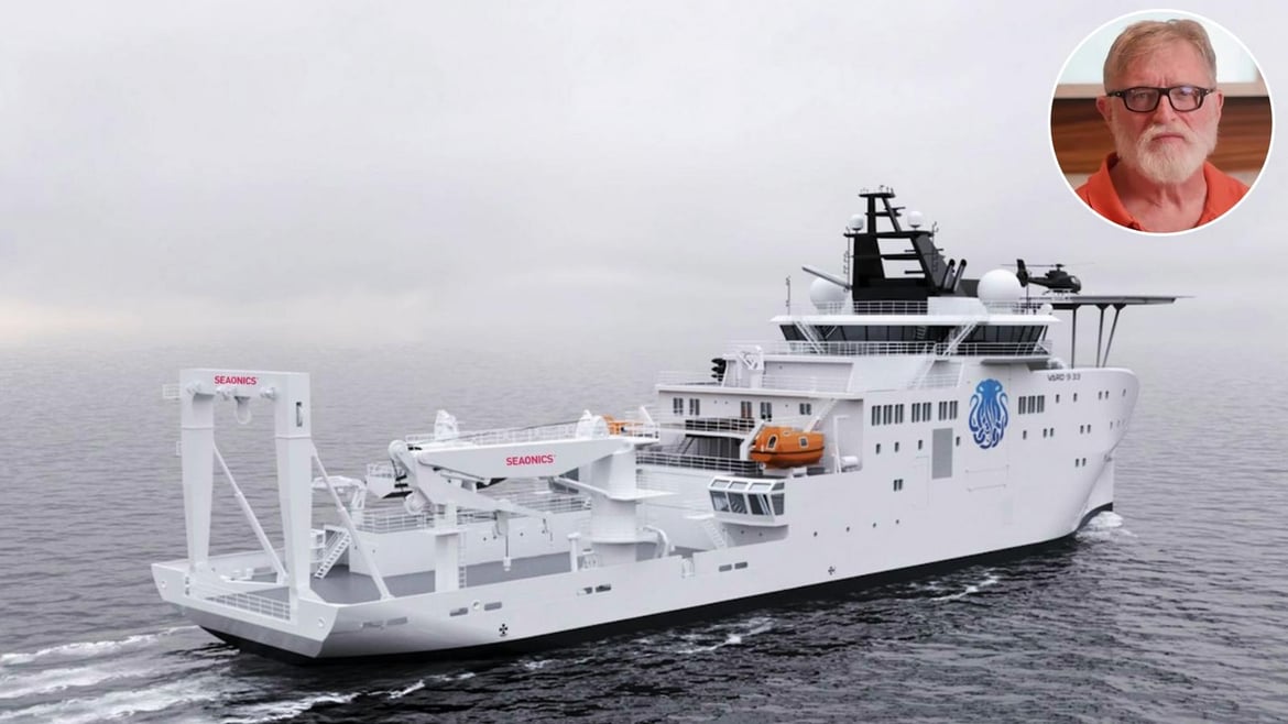
When a billionaire decides to build a 100-meter (about 328-foot) deep-ocean research vessel, the spotlight usually falls on the hull, the submersibles, and the headline budget. Yet the real story often sits in the hardware that actually puts steel and sensors into the water. That is where Seaonics enters the frame, as Gabe Newell pushes forward with what is poised to become the world’s most sophisticated research vessel.
The Vard shipyard
Last year, Seaonics announced it had signed a contract with Vard to deliver a complete research package for Inkfish’s $300 million RV6000.
The Norwegian maritime technology company, a specialist in mission-critical handling and lifting systems, is a subsidiary within the Vard ecosystem.
That detail matters.
The cranes, winches, and launch systems destined for RV6000 are not being sourced from a generic third party and retrofitted later.
They are being engineered in the same industrial family as the hull and systems integration, aligning structure, power, and control logic from the outset.
Seonics describes the contract as a flagship project that showcases high operability and reliability for demanding oceanographic missions.
It also subtly reinforces that RV6000 is joining a growing, purpose-built research fleet alongside RV Hydra and RV Dagon, positioning the vessel as the technological centerpiece of Gabe Newell’s expanding marine science ambitions rather than an isolated vanity project.
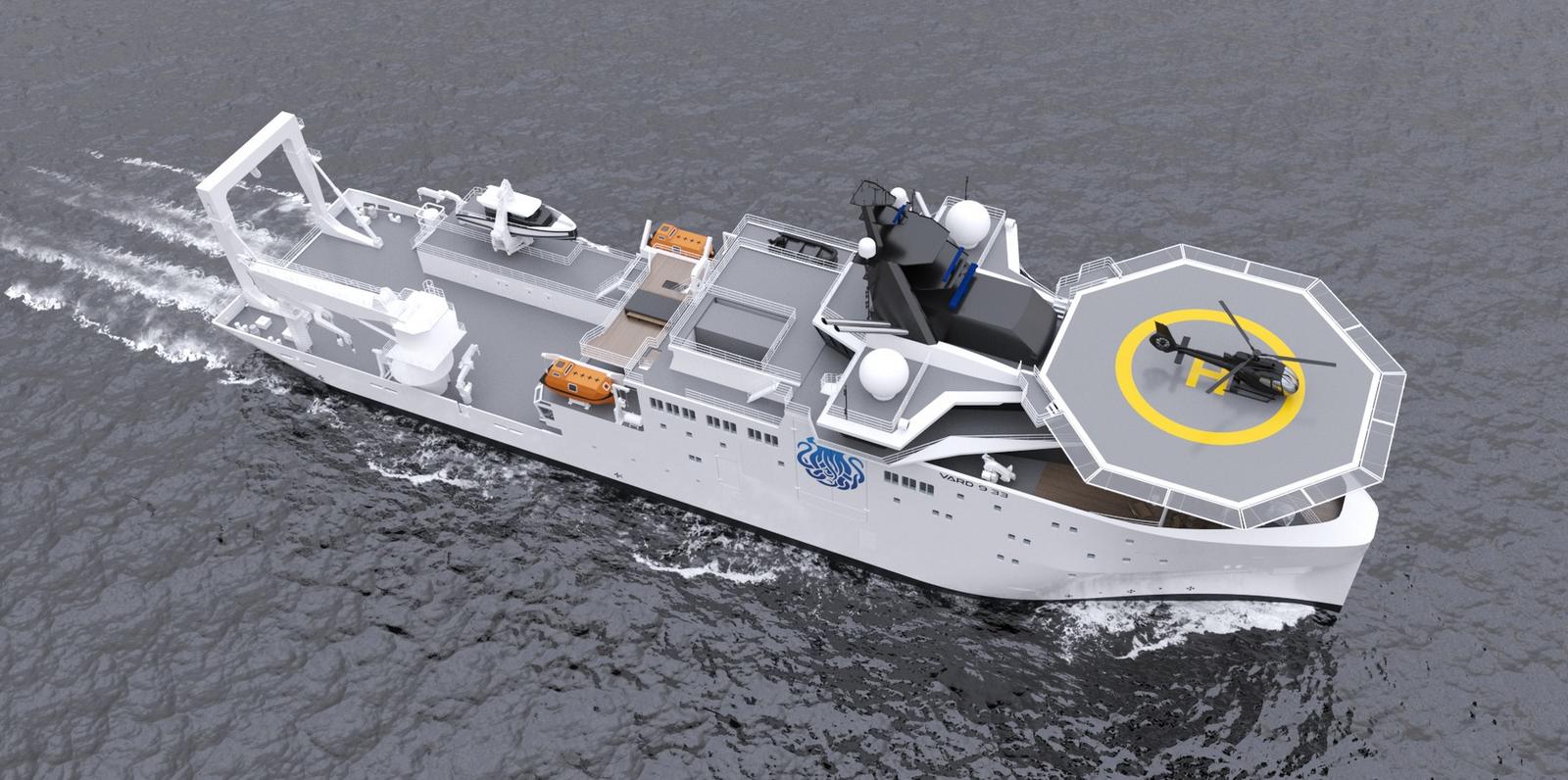
Also installed will be a LARS (Launch and Recovery System)
The package itself forms the mechanical backbone of the ship.
A large stern A-frame system will pivot out over the water, providing controlled launch and recovery of heavy subsea gear in the vessel’s wake, where turbulence can be better managed.
A dedicated scientific winch system will handle CTD casts, coring operations, towed arrays, and the long umbilicals required for deep deployments.
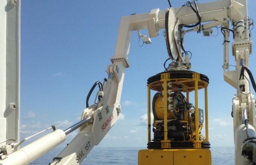
These winches are based on Seaonics’ electric and hybrid technologies, capable of regenerating electrical power back into the ship’s grid while paying out cable, reducing overall energy demand during intensive operations.
A Seaonics marine deck crane
A purpose-built Launch and Recovery System for ROV work will support Inkfish’s 6,000-meter-class remotely operated vehicles.
Designed with intelligent control, active heave compensation, and remote operation capability, the LARS manages the critical transition through the wave zone, where vessel motion can otherwise translate into damaging shock loads.
Completing the quartet is a multi-purpose offshore crane on the starboard side, specified with active heave compensation and configured for deep operations down to around 2,500 meters.
It will serve as the workhorse for heavier subsea packages and equipment that support both robotic and potentially crewed missions.
The underlying technology is as important as the hardware itself.
Active heave compensation systems sense the vessel’s vertical motion and automatically adjust cable length to keep the load as stable as possible relative to the seabed.
For a 6,000-meter ROV descending through rough surface conditions, that stability can mean the difference between a controlled deployment and a catastrophic failure.
Electric and hybrid drives further reduce noise and vibration, an advantage not only for crew comfort but also for sensitive acoustic mapping instruments that depend on a quiet platform.
Gabe Newell
All of this engineering converges on RV6000, the research flagship commissioned by Gabe Newell through Inkfish.
Built by Vard and scheduled for delivery in the second quarter of 2028, the vessel is designed for multi-month missions with up to 70 scientists and crew onboard.
With Seaonics providing the arms and muscles that will lower humanity’s tools into the abyss, RV6000 moves from concept to capability, edging closer to becoming one of the most advanced privately funded research ships ever launched.
NavimetriX just launched the ECMWF IFS 0.1° model. It is the global atmospheric model with the highest resolution available. It is often considered the best global model available. Veterans know it as CEP, ECMWF, the European model, or simply “high res.”
Until now, it was only accessible in GRIB format via Squid with the Racing subscription at €540/year, or PredictWind with the Pro subscription at $500/year.
It is included in the NavimetriX Premium subscription at no extra cost.
Resolution: 0.1° × 0.1° (9 km)
Parameters: wind at 10 m, gusts, sea-level pressure
Time step: hourly up to 24 hours, then 3-hour intervals up to 6 days, then 6-hour intervals up to 15 days
Runs: 00Z, 06Z, 12Z, and 18Z (4 runs per day)
Availability: approximately 8 hours after each run (08:00, 14:00, 20:00, 02:00 UTC)
In China, the study of geopolitics was long banned. Since Xi came to power, it has experienced a renaissance through maps. Nadège Rolland, a researcher specializing in Chinese strategy, has authored an in-depth study on the cartographic representations of the new empire.
The 2023 edition of the “standard” map of the borders of the People’s Republic of China, which includes the disputed land and maritime areas with India, Malaysia, the Philippines, Russia, Vietnam, and Taiwan, starkly highlighted the Chinese government’s tendency to instrumentalize the representation of space and its desire to shape reality rather than reflect it 1.
We recall similar precedents, such as the now-famous “nine-dash line” encompassing the South China Sea, which appeared as an attachment to its note verbale addressed to the UN in May 2009; its adoption in 2021 of the Land Boundary Law; and the recent renaming of villages in Xinjiang and along the borders with Russia and India.
These various examples link contemporary Chinese maps to the so-called “maps of national humiliation,” produced during the 1920s and 1930s, which depict the territories that once belonged to the Qing Empire as phantom limbs following an amputation. The abrupt transition from empire to nation-state, triggered by Western invasions in the 19th century, was in fact accompanied by a dismemberment of the Chinese “geo-body”—which current leaders intend to repair while simultaneously declaring their desire to wash away the centuries-old affront. 2
Thus, contemporary Chinese territorial claims result, at least in part, from the irreconcilable boundaries of the former imperial domain and the modern sovereign state.
« Carte de l’humiliation nationale chinoise » (1927). Source : William A. Callahan, “The cartography of national humiliation and the emergence of China’s geobody” Public Culture 21(1) 2009.
While the “national humiliation” maps speak volumes about China’s past wounds, the map created by geophysicist Hao Xiaoguang—made public in 2014 and adopted by the Central Military Commission in 2019—instead outlines a vision of China’s future and the place it hopes to occupy on the international stage.
Hao’s vertical projection places China, the Indian Ocean, and the Himalayan plateau at the center of a vast space bounded to the north and south by the poles, to the west by the African continent, and to the east by the Pacific and Oceania.
Contemporary Chinese territorial claims stem from the irreconcilable boundaries of the former imperial domain and the modern sovereign state. NADÈGE ROLLAND
The Atlantic Ocean and the American continent, split in two and compressed by the projection, are relegated to the edges of the map.
Projection de Hao Xiaoguang, 2014.
The decade Hao spent working on the creation of this new world map—which dethrones the East-West axis and eliminates the centrality of the transatlantic—coincided with a period of intense internal reflection during which Chinese strategic planners and academic experts set out to dissect the multiple dimensions of power.
It was during this same period that China collectively became aware of its meteoric rise, marked by uninterrupted double-digit growth accelerated by its integration into the international system and its entry into the World Trade Organization in 2001—and its ascension to the position of the world’s second-largest economy, overtaking Japan in 2011. At this rate, it would soon surpass the United States.
What kind of great power would it then become?
In an effort to provide answers to these questions, numerous internal research studies during this period focused on analyzing the concepts of maritime and naval power, the notion of soft power, and the historical cycles of the rise and decline of great powers, while also attempting to determine China’s geopolitical nature and define the “core interests” of the Chinese nation.
Developed within strategic circles, this line of thinking accompanied and supported the ruling bodies of the party-state, which, increasingly confident in the country’s upward trajectory, began to show the first signs of publicly asserting its identity as an emerging global power. Perhaps inspired by the study session on the rise of great powers in which all members of the Chinese Communist Party’s Political Bureau had participated a few months earlier, the Hu Jintao government launched the concept of “peaceful emergence” in late 2003, which was quickly replaced by that of “peaceful development”—Chinese propagandists having, upon reflection, deemed the term “emergence” too aggressive.
Then, in 2005, the General Secretary finally announced his desire to see the emergence of a “harmonious world,” thus setting forth the first outline of a truly global vision. In addition to adopting a rhetoric that blended power with global horizons, Hu Jintao also ordered the People’s Liberation Army (PLA) to accelerate the development of its projection capabilities far beyond the mere national perimeter, listing in late December 2003 “new historic missions” focused on defending China’s economic development and national maritime interests, including in space and cyberspace.
Officially banned in the People’s Republic until the late 1980s, the discipline of geopolitics has since regained influence in Chinese strategic thinking. NADÈGE ROLLAND
At the center and at the top of the world: maps to establish China’s geopolitical nature
Gradually coming to realize their nation’s growing strength, the Chinese elites nevertheless remained divided for some time yet on the course of action to take and the strategy to adopt.
Then, in 2005, the General Secretary finally announced his desire to see the emergence of a “harmonious world,” thus setting forth the first outline of a truly global vision. In addition to adopting a rhetoric that blended power with global horizons, Hu Jintao also ordered the People’s Liberation Army (PLA) to accelerate the development of its projection capabilities far beyond the mere national perimeter, listing in late December 2003 “new historic missions” focused on defending China’s economic development and national maritime interests, including in space and cyberspace.
Officially banned in the People’s Republic until the late 1980s, the discipline of geopolitics has since regained influence in Chinese strategic thinking. NADÈGE ROLLAND At the center and at the top of the world: maps to establish China’s geopolitical nature
Gradually coming to realize their nation’s growing strength, the Chinese elites nevertheless remained divided for some time yet on the course of action to take and the strategy to adopt.
While civilian intellectuals largely remained committed to the principle of strategic prudence and “keeping a low profile” articulated by Deng Xiaoping in the early 1990s, military circles adopted a more nationalist stance and advocated a maximalist vision of China’s role on the international stage. Following the 2008 financial crisis, several Chinese military officers notably campaigned publicly for China to become a dominant global power. Their work, inspired by an organicist and bellicose vision reminiscent of the geopolitics of Ratzel and Haushofer, described China’s need to acquire “living space,” maintain unimpeded access to natural resources, and the state’s necessary struggle for survival within an existing order considered fundamentally unjust 3.
Xi Jinping’s rise to power in the fall of 2012 marked the end of the debate and a noticeable alignment of the civilian and military spheres behind the goal of positioning China at the center of the world and at the top of the hierarchy of major powers. Evident in Hao Xiaoguang’s vertical map, this desire for a central position on the global stage has also become more apparent in China’s conduct of international affairs since Xi assumed political leadership of the Chinese Communist Party.
The internal deliberations on China’s (re)positioning at the center and at the top of the world that took place during the first decade of the 21st century were accompanied by a line of thinking that closely linked power and space. Officially banned in the People’s Republic until the late 1980s, the discipline of geopolitics has since regained influence over Chinese strategic thinking. Traces of this can be found, in particular, in studies on China’s interest in developing its control over maritime spaces and eventually becoming an “oceanic superpower,” or in works that define China as a “composite continental-maritime ” (陆海复合国家 luhai fuhe guojia) and seek to assess the geostrategic risks faced by such a hybrid power when it decides to develop its naval capabilities.
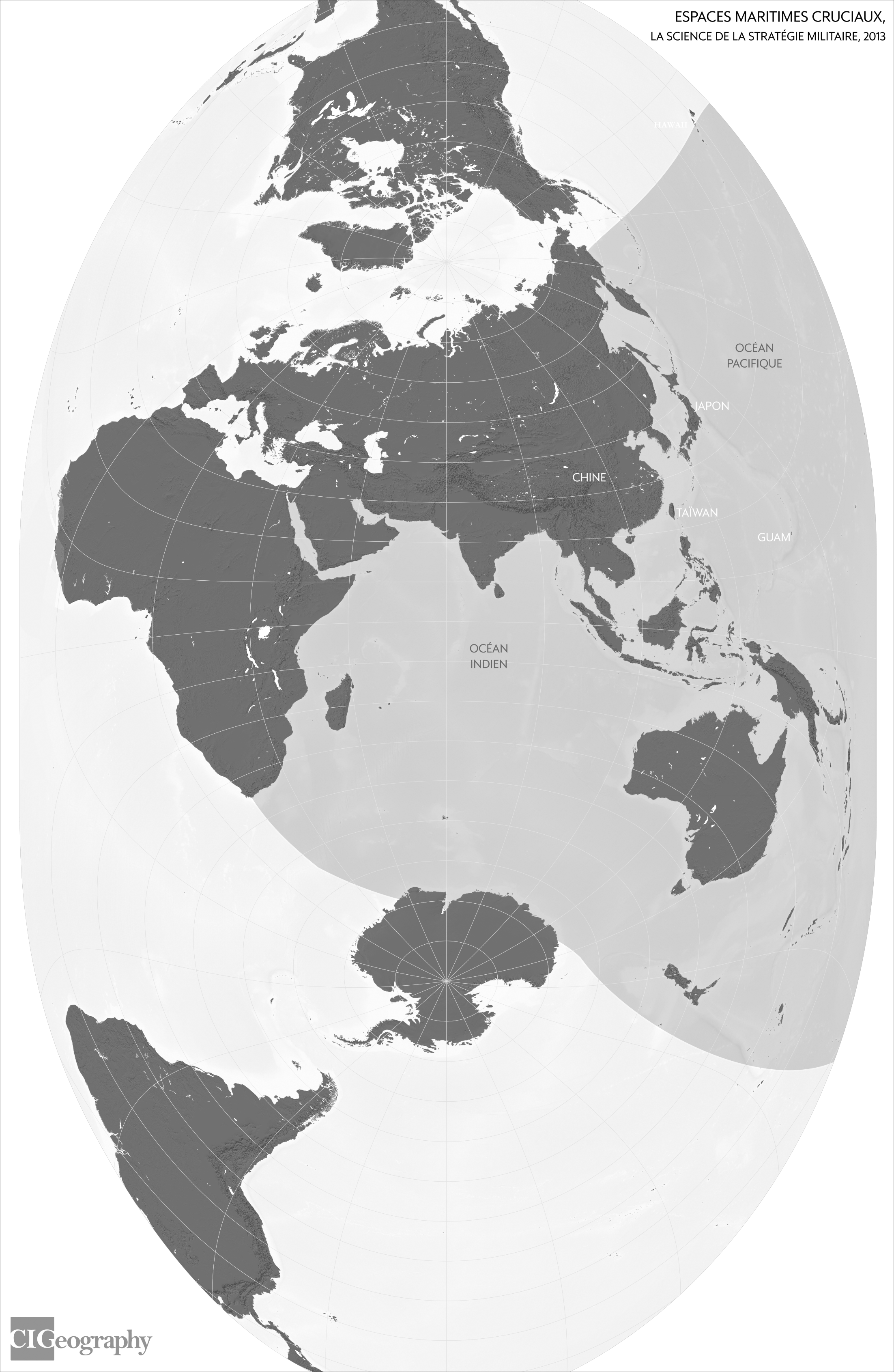
China’s strategic space according to the doctrinal work *The Science of Military Strategy* (2013). Map by Louis Martin-Vézian, CIGeography, 2024
Geographic representation of the “C-shaped encirclement.” Map by Louis Martin-Vézian, CIGeography, 2024
Geopolitical principles also serve as a framework for interpreting the logic behind U.S. grand strategy, from the first Cold War against the USSR to the second, which, according to Chinese experts, was already taking shape against Beijing following the Soviet collapse. This deterministic framework, which infers a desire on the part of the United States to contain any rival power as soon as it emerges in Eurasia, leads to the interpretation of any action coming from the West as hostile and leaves little room for conciliation or accommodation — resulting in a security dilemma that gestures of reassurance or appeasement can hardly resolve.
This geopolitical perspective also shapes a conception of space that is both expansive and contested. Expansion and contraction play out across a multidimensional terrain—land, sea, air, outer space, and cyberspace; tangible and intangible. Expansion beyond national borders is presented as the natural result of the state’s growing power, just as it is seen as necessary for its survival and sustainable prosperity. Consequently, space becomes a site of confrontation, as expansion must occur at the expense of territories under foreign sovereign jurisdiction or within de facto undivided global spaces dominated by advanced nations that deny the same privileges to “lagging countries.” 4
From this interplay between expansionist desire and external constraints arises the definition of Chinese strategic space (战略空间 zhanlüe kongjian), justified both for defensive reasons—the formation of a strategic depth zone enabling resistance to potential external aggression—and offensive reasons—the establishment of a sphere of influence beyond national borders to ensure the state’s survival.
The Imaginary Pincer Movement: The Fear of Encirclement as a Strategic Framework
At a time when Hu Jintao was describing China as an emerging power and promoting the vision of a harmonious world, his advisors were watching with concern a number of developments that they attributed to the United States’ desire to constrain the strategic space of its rivals.
The color revolutions in Georgia (November 2003), Ukraine (November 2004), and Kyrgyzstan (March 2005), the accession of seven former Warsaw Pact signatories to NATO (March 2004), and the decision at the Istanbul Summit to strengthen the Atlantic Alliance’s presence in Afghanistan, were, in their view, part of the same logic of ideological and military encirclement aimed at containing Russia’s western and southeastern flanks.
China’s strategic space, a collateral victim of these maneuvers given its geographical proximity to Russia, was, they believed, also the primary target.
From their perspective, while Western powers were striving to transform the Chinese political system through their “peaceful evolution” strategy, they were also methodically building a military encirclement in the shape of an inverted C, with Guam at its epicenter. The “pivot to Asia” policy adopted by the Obama administration in 2011, or the vision of a “free and open” Indo-Pacific region championed by the Trump and Biden administrations since 2017, were merely the most recent demonstrations of the U.S. determination—already affirmed in the 2001 Quadrennial Defense Review—to prevent any strategic competitor from gaining a foothold on the Eurasian continent.
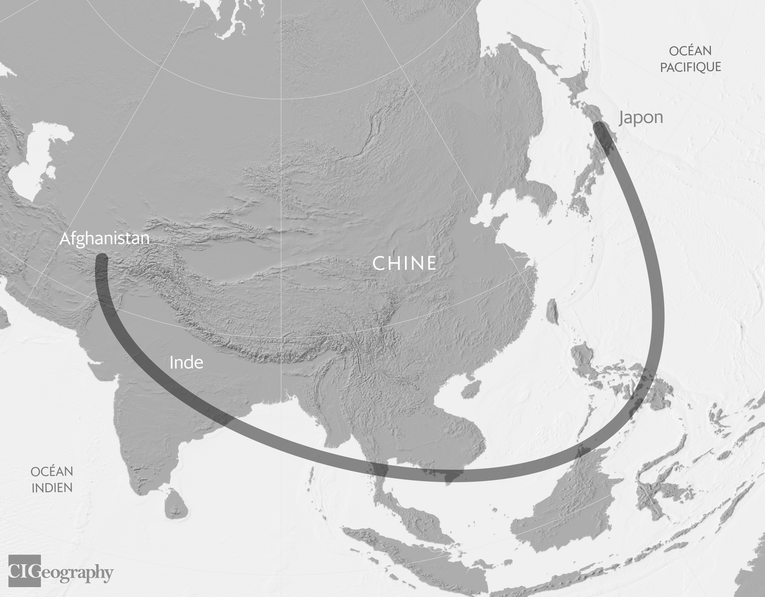
The fantasy of encirclement, depicted as the U.S. “pincer movement” around China. Map by Louis Martin-Vézian, CIGeography, 2024
The fortress complex and the portrayal of a Chinese strategic space under pressure on multiple fronts go hand in hand with an attempt to develop a framework for expansion justified by the need to break through enemy encirclement and define a strategic direction for the country in line with its material capabilities and national interests.
Mapping the Chinese strategic space reveals that contemporary China has never truly conceived of itself as a regional power, NADÈGE ROLLAND
The Heart Grows in the Peripheries: A Conceptual Grammar of Expansion
Developed over the decade mentioned above, three key concepts that are now part of this new grammar of expansion were eventually incorporated into the official canon beginning in 2013.
They are essential to understanding China’s grand strategy. The first is that of “new strategic frontiers” (战略新疆域 zhanlüe xin jiangyu), which includes the polar regions, outer space, and the seabed. As terra nullius untouched by human presence, these new frontiers are seen as offering China the opportunity to shape the governance rules governing them, thereby perhaps achieving a form of symbolic claim to these uninhabitable territories.
The second confirms key strategic directions: maritime expansion into the South Pacific and the Indian Ocean; the “Western Advance” (西进 xijin), which envisions continental expansion toward Central and South Asia and beyond, toward the Middle East (“Western Asia” in Chinese); and finally, the development of an outer belt encompassing Latin America, Africa, and Europe, in order to break through the U.S. encirclement focused on the Indo-Pacific. Finally, the third strategy centers on the concept of the “periphery” (周边 zhoubian), which introduces the idea of “distant neighbors”—that is, countries connected to China not by a shared border, but through their economic, security, and cultural/ideological ties with it. The “minor” periphery comprises the four subregions in which China’s neighbors are located (Northeast, Southeast, South, and Central Asia), while the “major” periphery includes the regions connected to each end of the minor periphery (the Middle East and Africa, as well as the South Pacific). China is, of course, the center of this “periphery,” which is visualized as a series of concentric circles.
From the Core to the Periphery: The Concentric Circles of China’s Strategic Space.
Maps by Louis Martin-Vézian, CIGeography, 2024
While the concept of the periphery was officially adopted by Chinese diplomacy as early as October 2013, the cardinal directions of China’s strategic space are reflected in the rollout of the so-called “New Silk Roads” initiative launched by Xi Jinping in the fall of 2013, which takes shape along two major axes—one maritime, the other continental—and encompasses all the countries of the so-called “Global South.”
How Xi Jinping Has Reinvigorated the Geostrategic Arena
Over the course of a decade, the geopolitical framework—initially purely theoretical—has given rise to the development of a geostrategy applied on a global scale.
Mapping China’s strategic space reveals that modern China has never truly viewed itself as a regional power, but instead developed a global vision at a very early stage, driven both by its expansionist ambitions and its fear of encirclement. The sketching of this mental map with gigantic contours coincided with a period of meteoric rise for the country. As China’s economic growth is now slowing, some Chinese strategic thinkers are now warning against the possibility of excessive expansion that would strain China’s capabilities and resources disproportionately.
This call for caution, however, does not seem to have been heeded by the General Secretary of the CCP, who continues to present the great rejuvenation of the Chinese nation as his primary goal by 2049 and to view the world as undergoing “upheavals the likes of which we have not seen in a century”—an official formulation that implies a shift in the global balance of power in China’s favor. How, in this context, can China fulfill its “manifest destiny,” at a time when, according to Xi Jinping, “Western countries, led by the United States, have launched a campaign of absolute containment, encirclement, and suppression against our country, posing serious and unprecedented challenges to our development”? A reduction of the boundaries of the mental map of China’s strategic space to the “minor periphery” does not appear to be on the agenda, given the Chinese government’s launch of four “global initiatives” (security, development, civilization, and governance). What is more likely to emerge is the maintenance of a global vision—now underpinned not only by the primacy of economic or military power but also by the development of political and ideological influence and a reshaping of international rules and norms aligned with the preferences of the Chinese leadership.
The intangible space would then become the true new frontier to be conquered in order to ensure the survival of the state and the preservation of China’s strategic space.
Sources :
Emmanuel Dubois de Prisque, “Cartography in China: From the ‘Chinese Dream’ to Geopolitical Reality,” Outre Terre 38(1), 2014.
William A. Callahan, “The Cartography of National Humiliation and the Emergence of China’s Geobody,” Public Culture 21(1), 2009.
Christopher Hughes, “Reclassifying Chinese Nationalism: The Geopolitik Turn,” Journal of Contemporary China 20(71), 2011.
Shou Xiaosong (ed.), Science of Military Strategy, Beijing, Military Science Press, 2013, p. 244.


 Photo taken on Aug.


 Model of Jiaolong submersible at the Five-Year Achievements Exhibition.
 Polymetallic nodules, such as those shown here, can occur on the ocean floor and are of interest for the critical minerals they contain.


 Chinese research vessel Xiang Yang Hong 06 is seen at Thilawa port in Yangon, Myanmar, Feb.
 Rosellid “mushroom” sponges on ferromanganese boulders mixed with smaller nodules upslope a North Atlantic Stepping Stones expedition in 2021.


.jpg)