Dive into the depths of the Taam ja’ Blue Hole (‘deep water’ in Mayan), located in Chetumal Bay, Mexico! Recent research findings expose the impressive nature of this karst structure, plunging to depths exceeding 420 meters below sea level, surpassing any other known blue hole in depth worldwide. Resembling a cenote, this captivating fully submerged structure features multiple layers of water, each with unique characteristics.
Notably, fluctuations in salinity suggest yet unexplored connections between Chetumal Bay and the Caribbean Sea.
Join us on this exciting underwater scientific expedition as we explore the enigmatic shapes of this natural wonder.
Discover the equipment utilized in these investigations, aimed at unraveling the secrets hidden within the blue hole system southeast of the Yucatan Peninsula.
From Hydro
Researchers have discovered the deepest sinkhole known on Earth, located underwater near the border of Mexico and Belize.
Researchers have discovered the deepest sinkhole known on Earth, located underwater near the border of Mexico and Belize.
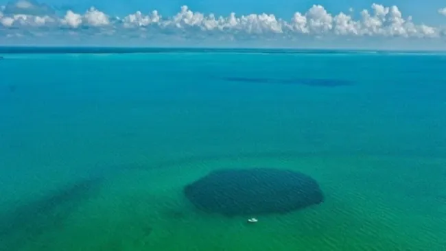
The Taam Ja' Blue Hole sits underwater in Chetumal Bay, Mexico.
When discovered, TJBH was believed to be only 30 meters deep in 2021, due to limitations in the echo-sounder technology.
When discovered, TJBH was believed to be only 30 meters deep in 2021, due to limitations in the echo-sounder technology.
However, in reality, it is deeper than the deepest blue holes on Earth.
(Image credit: Joan A. Sánchez-Sánchez)
Previously believed to be the second-deepest of its kind, the Taam Ja’ Blue Hole (TJBH) is now recognized as the deepest known blue hole, with its bottom still uncharted.
A recent paper published in the journal Frontiers in Marine Science suggests that the TJBH plunges to at least 420 metres below sea level.

Named ‘Taam Ja’’ in Yucatec Maya, which translates to ‘deep water’, the blue hole has proven to be a challenging depth to measure precisely for the research team.
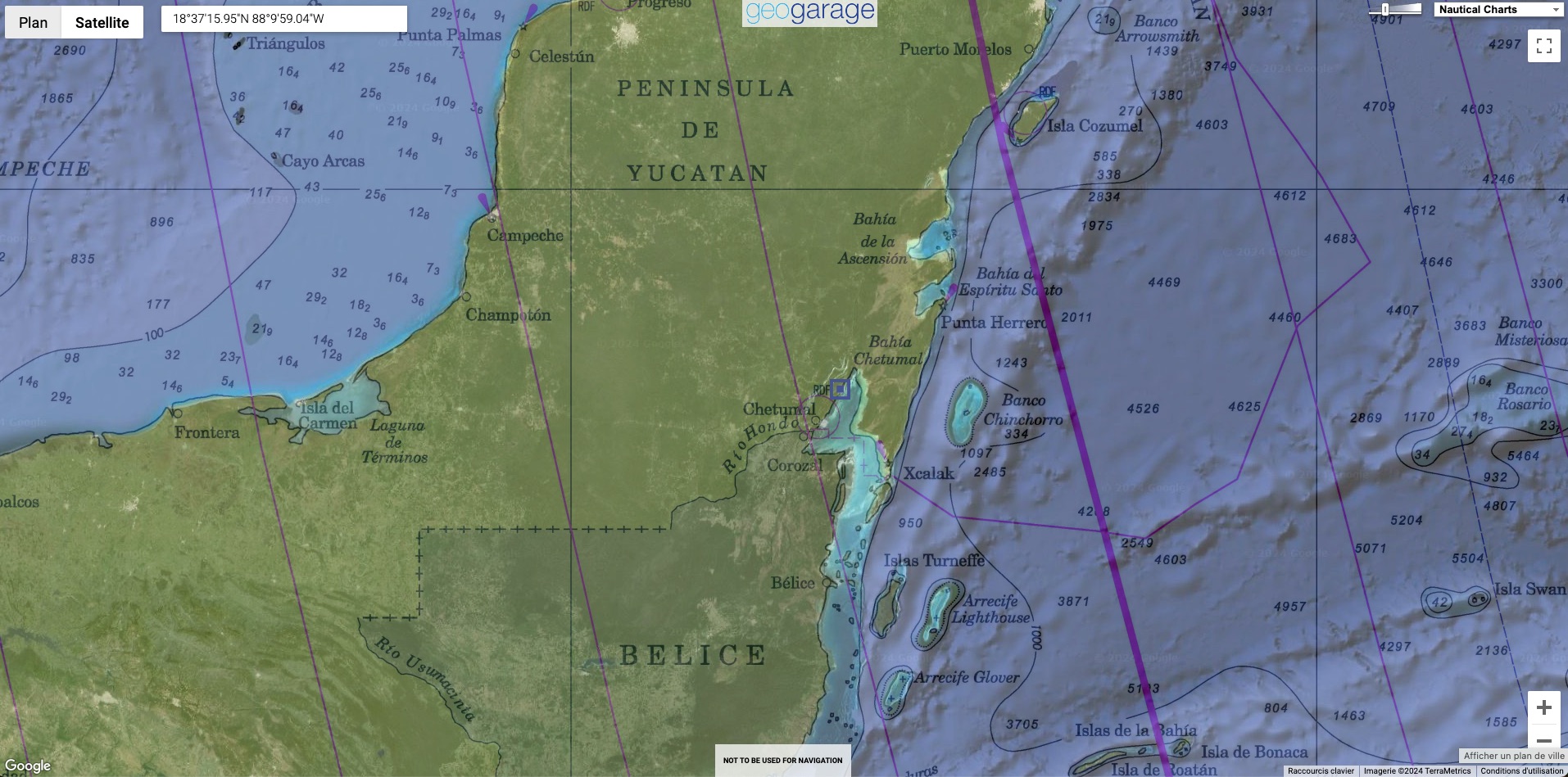
Scientists have been studying coastal karst formations in Chetumal Bay, Mexico, south-east of the Yucatan Peninsula, focusing on these remarkable structures known as blue holes.
One of these, the TJBH, was initially measured at approximately 274 metres deep using echosounder mapping, establishing it as the second-deepest blue hole in the world at the time.
However, the use of echosounders in complex environments such as blue holes presents challenges due to factors such as varying water density and cave shapes.
Initial attempts to explore the TJBH’s depth did not reach the bottom, necessitating further investigation.
Further exploring the blue hole
Recent measurements employing a CTD (conductivity, temperature, depth) profiler found depths exceeding 420 metres, confirming TJBH as the world’s deepest known blue hole.
The research also revealed different layers of water within the TJBH, indicating connections to other water bodies such as the Mesoamerican Barrier Reef System.

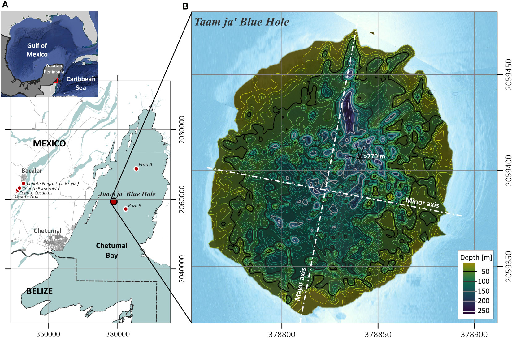
Location of the Taam ja’ Blue Hole
(TJBH) in Chetumal Bay, Mexico, is presented alongside the CC and CSW
data regions for further comparison of water temperature and salinity
conditions.
Regional fracture zones and geological faults in the Yucatán Peninsula are indicated (INEGI, 2002), along with the locations of documented blue holes within Chetumal Bay.
CB
data was measured at sampling stations positioned at cardinal positions
~500 m apart of the TJBH (TJBHN, TJBHS, TJBHE and TJBHW).
Images from scuba explorations of the TJBH at depths (B) 5.0 mbsl, (C) 20 mbsl, and (D) 30 mbsl are also presented.
As described in the Frontiers in Marine Science paper by Alcérreca-Huerta et al. (2023), new CTD profiles were conducted within the TJBH.
Using a SWiFT CTD profiler from Valeport, a UK-based manufacturer of oceanographic instrumentation, single profiles were taken at each campaign with simultaneous measurements of water pressure, temperature and conductivity throughout the water column.
Featuring survey-grade sensor technology, the SWiFT CTD profiler offers the convenience of Bluetooth wireless technology, a rechargeable battery and an integrated GNSS module for accurate profile geolocation.
The coordinates for the CTD profiles were 378830.7m E and 2059383.6m N (UTM 16Q), based on preliminary echosounding measurements indicating water depths exceeding 250 metres below sea level.
The vessel was anchored to prevent drifting caused by waves and currents.
In this specific location, the CTD instrument was lowered, utilizing approximately 500 metres of cable down to the bottom, adhering to the maximum depth supported by the instrument.
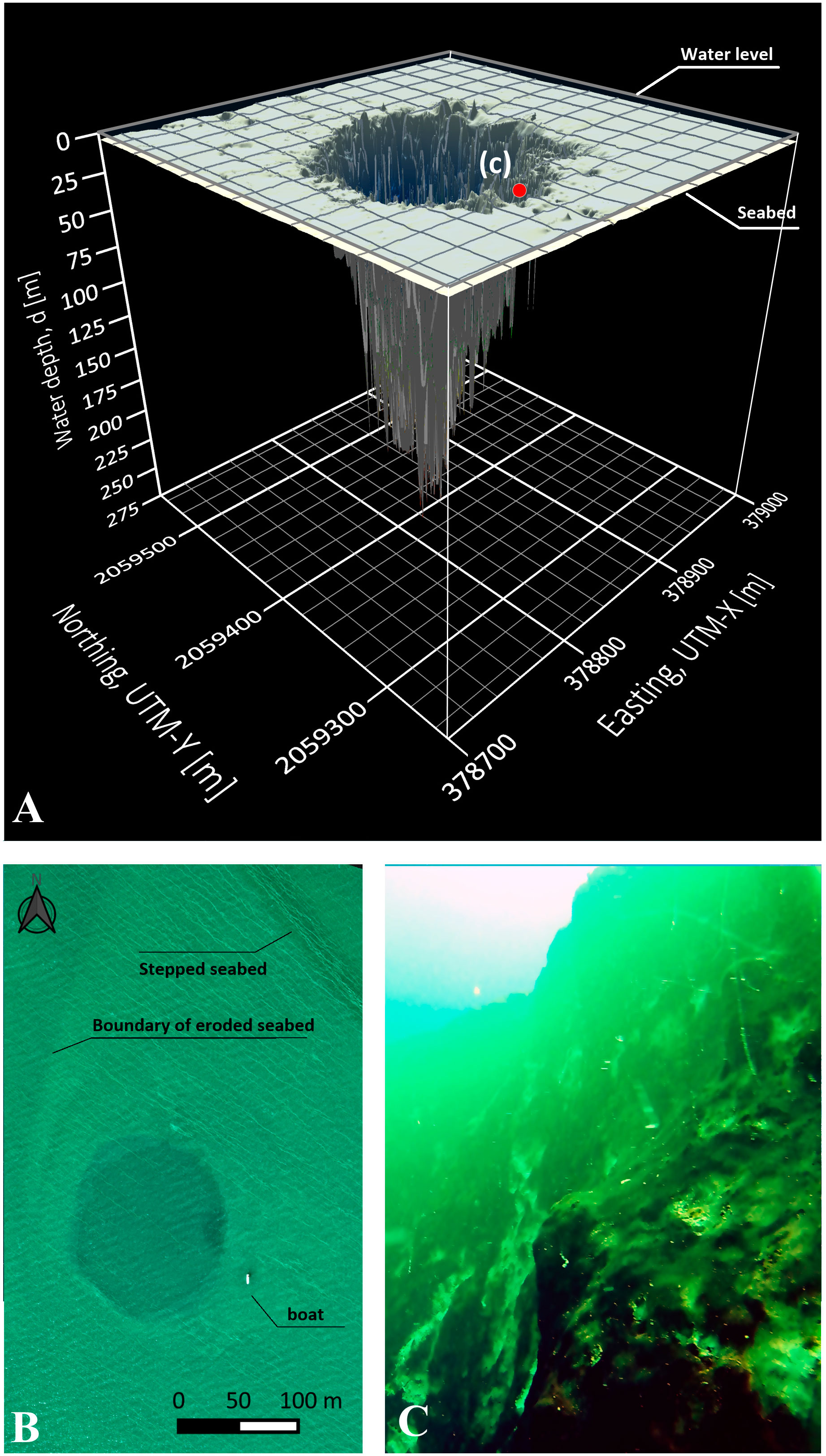
3D morphological map of the TJBH (UTM 16Q) starting at the seabed of Chetumal Bay (~5.0 mbsl) and descending to a depth of 274.4 m depth.
(B) Aerial drone image of the blue hole, seabed features surrounding the entrance of the blue hole and size comparison with a boat (8.5 m length).
(C) Subaquatic view of the mouth of the hole from 20 mbsl oriented along the southern wall (location c pointed out in panel A).
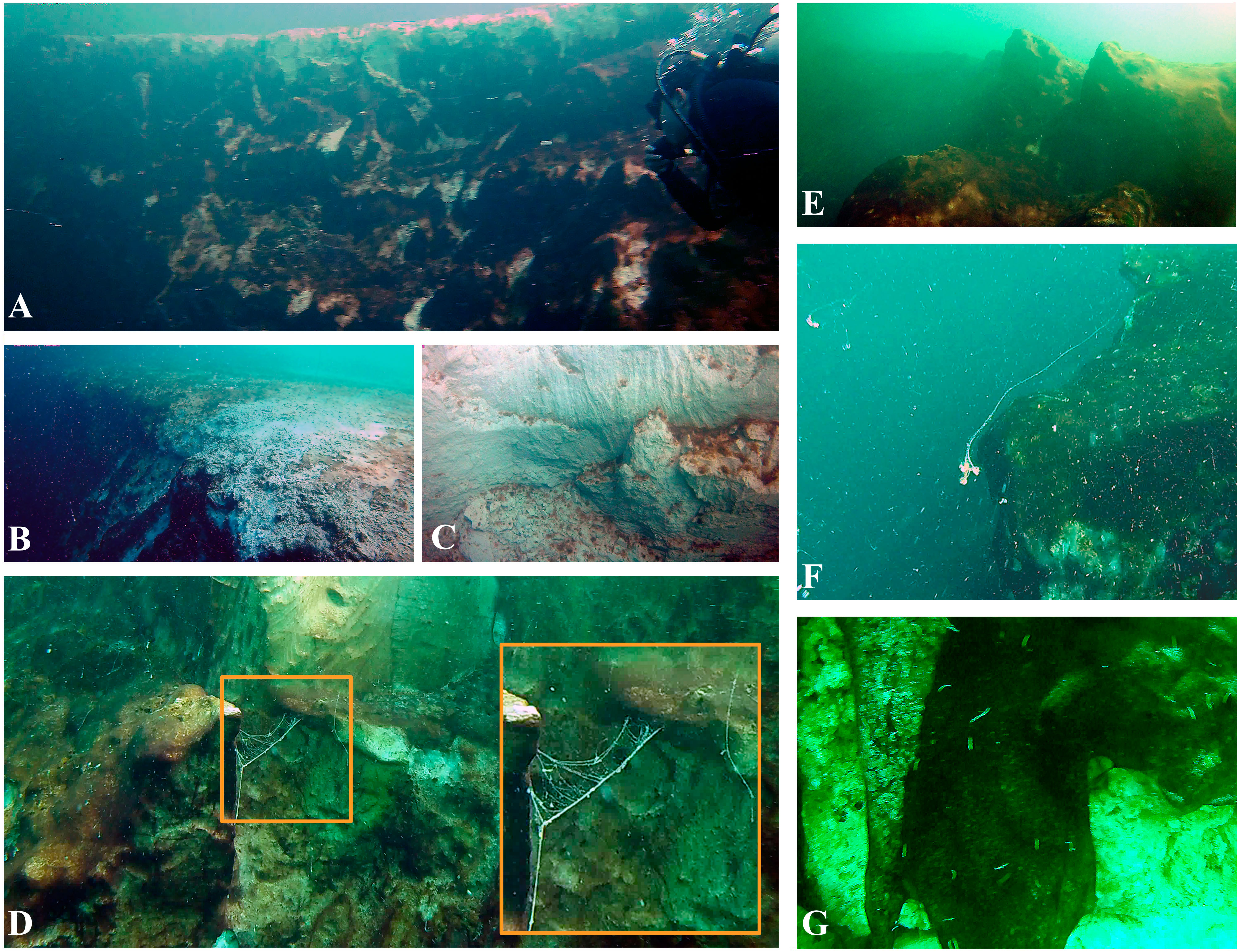
(A, B) Entrance border at the southern wall of the blue hole surrounded by a flat limestone platform, which is part of the Chetumal Bay seabed.
(C, D) Exposed white patches of limestone from rockslides are intercalated with biofilms and (E) limestone rocky ledges of 2-3 m.
(D, F) Detail of mucoid filaments floating in the waters of the blue hole and attached to its walls, and
(G) worms of ~0.01-0.02 m and biofilms covering exposed limestone over which dead barnacles were observed.
The research team now plans to further explore the TJBH using robots and unmanned submarines to map its depths accurately.
Advanced underwater navigation technologies will be used in conjunction with CTD profilers to provide a detailed three-dimensional spatial representation of the TJBH and its geomorphological features and water depths.
Links :
- First scientific documentation and records of the Taam ja' Blue Hole / Morphological characteristics and temporal variability of water in the Taam ja' Blue Hole
- Explorer Web : World’s Deepest Blue Hole Discovered
- LiveSciences : Deepest blue hole in the world discovered, with hidden caves and tunnels believed to be inside
- BBC : Scientists can't find bottom of deepest hole in ocean
- Phys : Taam Ja' Blue Hole in Mexico's Chetumal Bay found to be deepest in the world
- ZMEScience : Nobody knows what’s at the bottom of Taam Ja’, the world’s deepest blue hole
- GeoGarage blog : Giant 'Blue Hole' found in Great Barrier Reef by marine biologist / Expedition into Belize Blue Hole could unlock ancient ... / Researchers just discovered the world's deepest ... / Image of the week : Great Blue Hole in the Belize Barrier ...
No comments:
Post a Comment