Saturday, September 18, 2021

Image of the week : Surface ocean currents around Antarctica

Source:
@ECMWF ORAS5. Used power scaling to bring out the slower currents < 1m/s.

Friday, September 17, 2021

Humans will always have oxygen to breathe, but we can’t say the same for ocean life

The surface layer of the ocean is teeming with photosynthetic plankton.
Though they're invisible to the naked eye, they produce more oxygen than the largest redwoods.

From The Conversation by Jean-Pierre Gattuso, Carlos M. Duarte, Fortuna Joos & Laurent Bopp

There is nothing more fundamental to humans than the availability of oxygen.
We give little thought to the oxygen we need, we just breathe, but where does it come from?

To shed light on this, statements such as “the ocean provides 50% of the oxygen we breathe”, or its equivalent, “every second breath we breathe comes from the ocean”, have become common mantras to highlight human dependence on the ocean and the risk of lower oxygen supply due to climate change and environmental degradation.

These mantras are repeated by high-profile politicians, including US climate envoy John Kerry and French president Emmanuel Macron, international organisations such as Unesco and the European Commission, and even prominent reports from the IPCC and other reputable scientific institutions.

While they may be good fodder for speeches, these claims misrepresent where the oxygen we breathe actually comes from, and in doing so, mislead the public as to why we should step up our role as ocean custodians.

Where do we get our oxygen?

The Earth’s atmosphere has not always been as rich in oxygen as it is today.
The atmosphere is now made up of 21% oxygen, but it accounted for just 0.001% of today’s levels during the first 2 billion years of Earth’s history.

It is the advent of microscopic ocean bacteria and plants (phytoplankton) and, later, larger plants on land which caused the staggering increase of oxygen in our atmosphere.
This oxygen is derived from photosynthesis – the process by which plants turn carbon dioxide and water into organic matter and oxygen.
Oxygen has been relatively stable at a high level for the past 500 million years.
Today, roughly half of photosynthesis takes place in the ocean and half on land.

So yes, the ocean is responsible for about 50% of the oxygen produced on the planet.
But it’s not responsible for 50% of the air we humans breathe.
Most of the oxygen produced by the ocean is directly consumed by the microbes and animals that live there, or as plant and animal products fall to the seafloor.
In fact, the net production of oxygen in the ocean is close to 0.
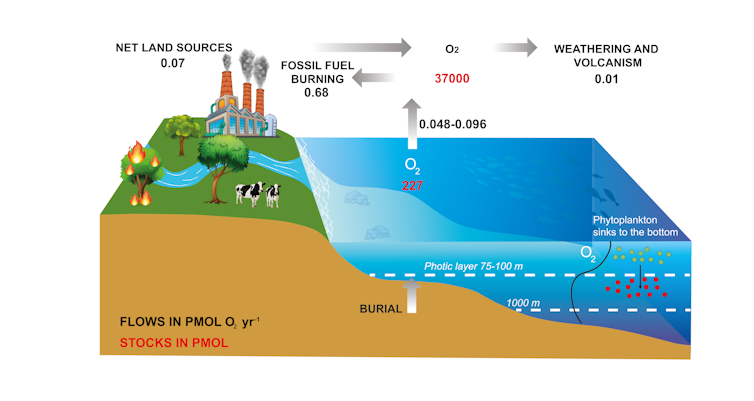
 
Oxygen produced by photosynthesis (i.e.net primary production) in the upper ocean is roughly consumed by respiration within the water column, except for a small excess production of 0.002 Pmol O2 per year which corresponds to burial in the ocean floor.
Redrawn from Grégoire et al., 2019, Fourni par l'auteur


A tiny fraction of the primary production, roughly 0.1%, escapes degradation and is stored as organic carbon in marine sediments – a process referred to as the biological carbon pump.
This organic carbon may eventually turn into fossil fuels such as coal, oil and gas.
The tiny amount of oxygen which had been generated to produce this carbon store can later be released to the atmosphere.
A similar process occurs on land too, with some carbon stored in soils.

Therefore, the oxygen we currently breathe comes from the slow accumulation of O₂ in the atmosphere supported by the burial of organic matter over very long time-scales – hundreds of millions of years – and not from the contemporary production by either the land or ocean biosphere.

Fossil fuels and the air we breathe


How about future trends of atmospheric oxygen? As early as 1970, the prominent geochemist Wally S Broecker recognised that if we were to burn all known fossil fuel reserves, we would use up less than 3% of our oxygen reservoir.

If we were to cut or burn all forests and oxidise all organic carbon stored in vegetation and top soils worldwide, it would only lead to a small depletion in atmospheric oxygen.
If photosynthesis in the ocean and on land stopped producing oxygen, we could continue breathing for millennia, though we would certainly have other problems.

The projected decline in atmospheric oxygen, even in the worst-case scenarios with massive fossil fuel burning and deforestation, will be very small relative to the very large atmospheric reservoir.
Models show that the content of oxygen in the atmosphere will experience a minute change over the next 100,000 years in response to fossil fuel use.
So while there are many things to worry about in our climate future, the availability of oxygen for air-breathing organisms (including humans) isn’t one of them.

Oxygen decline in the ocean

There are significant causes for concern regarding the content of oxygen in the ocean, however.
The ocean’s O₂ reservoir is vulnerable because it holds less than 1% of the oxygen stored in the atmosphere.
In particular, ocean regions with very low or absent oxygen, referred to as oxygen minimum zones, expand as the planet warms, making new regions inhabitable for breathing organisms like fish.

The open ocean lost 0.5 to 3.3% of its oxygen stock in the top 1000 metres from 1970-2010, and the volume of oxygen minimum zones has increased by 3-8%.

This oxygen loss is primarily due to increasing ocean stratification.
In this process, the mixing of the surface ocean, which becomes warmer and lighter, with the deeper and denser ocean layers is less efficient, restricting the penetration of oxygen.
The activity of enzymes, including those involved in respiration, also generally increases with temperature.
So, oxygen consumption by ocean creatures increases as the ocean warms.
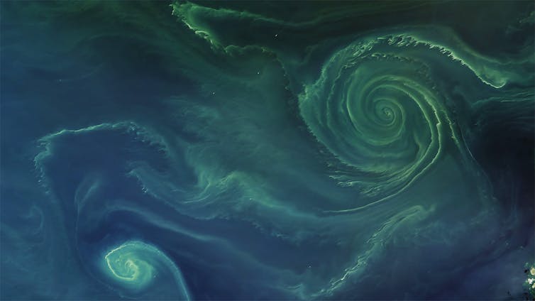
 
Most of the oxygen produced by the ocean is directly consumed by the microbes and animals that live there.
Sean Doran, CC BY-NC-ND


A recent study found that oxygen minimum zones in the open ocean have expanded by several million square kilometres and hundreds of coastal sites now have oxygen concentrations low enough to limit animal populations and alter the cycling of important nutrients.
The volume of low-oxygen areas is projected to grow by about 7% by 2100 under a scenario of high-CO₂ emissions.
Deoxygenation of this kind affects biodiversity and food webs; and negatively affects food security and livelihoods of the people who depend on it.

The facts


So where does this leave our mantra?

While it is incorrect to say that the ocean provides 50% of the oxygen we breathe, it is correct to say that, over geological time scales, the ocean has provided a large fraction of the oxygen we take in today.
It is also perfectly correct to say that the ocean is responsible for 50% of primary production on Earth, sustaining our food system.

And while we should not worry about the future supply of oxygen for humans to breathe in the future, we should worry about fish being increasingly displaced from expanding ocean areas that are depleted in oxygen.

Links :

Thursday, September 16, 2021

The ‘longest sediment avalanche ever measured’ tore up underwater seabed cables In West Africa

Congo Canyon with the GeoGarage platform (UKHO raster chart)

Satellite image of Congo Canyon in the Atlantic Ocean off the coast of Africa, where the largest sediment flow ever recorded occurred. Image: Wikimedia Commons
 
From Inertia by Alexandro Haro

On January 14, 2020, a swollen river full of sediment hit the Atlantic Ocean.
Some of that sediment started flowing down an underwater hill off the coast of West Africa.
Within hours, that flow had turned into what scientists believe is the “longest sediment avalanche ever measured.
It continued for two straight days, moving some 700 miles across the floor of the Atlantic, finally slowing to a halt on January 16.
Before it stopped, it was measured moving at speeds up to 26 feet per second.

source : Britannica

An international team of researchers reported that the avalanche started from the mouth of the Congo River and moved into the Congo Canyon, one of the largest submarine canyons in the world.
When all was said and done, the avalanche reached down to a depth of nearly three miles.

The massive flow broke two telecommunications cables that ran along the seabed: the SAT-3 (South Atlantic 3) and WACs (West Africa Cable System).
 
Mooring locations in the Congo Canyon. (A) Map of the Congo Canyon showing study area (rectangle), with bathymetric contours in meters. (B) Map showing the location of the two moorings deployed in 2013 (6, 57). (C) Map showing location of 2010 mooring (5). (D) Cross-canyon profile showing ADCP suspended 85 m above the canyon floor. Location of cross section indicated in (C).
source : ResearchGate

“We had a series of oceanographic moorings that were hit by the event, which broke them from their seafloor anchors so that they popped up to send us an email,” Durham University’s Professor Peter Talling told BBC News.
“This thing gradually got faster and faster. Because it erodes the seabed as it goes, it picks up sand and mud, which makes the flow denser and even quicker. So, it has this positive feedback where it can build and build and build.”

According to IFLScience, one of the reasons behind the enormous slide could be flooding. “December 2019 saw a major flood of the Congo river, something described as a one-in-50-years event,” Dr. Alfredo Carpineti explained
“In Kinshasa, the capital of the Democratic Republic of the Congo, the river was at its highest since 1963, with a discharge of 72 million liters (19 million gallons).”


How a turbidity current works. Image: NOAA/Wikipedia

That flooding hit the Congo estuary at the end of December, 2019.
Two weeks later, a turbidity current formed. A turbidity current is when a large amount of sediment increases the density of the water and it begins to flow downhill at a rapid rate.
Ten weeks after the first one formed, a second was created.
That happened to coincide with strong spring tides, and the team of researchers that looked into the event believe that may have been the spark that lit the proverbial dynamite.
 
Links :

Wednesday, September 15, 2021

BMT unveils highly autonomous warship technologies project


From Shephardmedia by Harry Lye

BMT Highly Autonomous Warship Technologies illustration. (Photo: BMT)
Design and engineering consultancy BMT has lifted the lid on its 'Highly Autonomous Warship Technologies' project, which is designed to help bridge the gap between current vessels and future lean-crewed autonomous warships.

BMT revealed its Highly Autonomous Warship Technology thought leadership programme at DSEI 2021 in London.

The programme aims to understand and enable philosophies behind future lean crewed warships enabled by autonomy.

While not a physical product, the project offers a view of how AI and intelligent systems can be integrated into the design of naval vessels and process ever-increasing quantities of data.

Jake Rigby, R&D lead for defence and security at BMT, said: 'It's not a concept design, but a thought leadership for a project about creating the vision of what a warship that is not completely uncrewed but has some very lean crewing onboard could look like in the future.'

Speaking to Shephard ahead of DSEI, he added: 'We're not saying that the future of naval warfare is completely unmanned; we're saying actually in this highly autonomous warship, you have a very small number of people that's enabled by autonomy, but you've still got some key functions onboard.'

The project looks ahead to a 2040 vision of a lean crewed warship designed in line with the UK government's upcoming 30-year shipbuilding strategy.

BMT wants to gain a sense of when certain enabling technologies will be matured and inserted into future vessels, producing a gradual pathway to more autonomous ships.

The vision of a highly autonomous vessel in 2040 does not necessarily mean an operationally deployed ship but rather one featuring a full range of mature autonomous capabilities.

Technical experts at BMT identified seven areas for the Highly Autonomous Warship Technology programme: navigation, warfare, recoverability, logistics and maintenance, platform systems, human factors and cyber security.

The thought leadership programme includes one whitepaper and seven individual technical papers.

As autonomous, lean-crewed ships increase over the next few decades, BMT anticipates a mix of vessels at sea operating different levels of autonomy.

Essential to the thought leadership work is promoting safety considerations around autonomous control and human factors. 
 

BMT Highly Autonomous Warship Technologies control room illustration. (Photo: BMT)

BMT chief engineer Ian Savage said: 'Over the next twenty years, BMT expects to see the increased adoption of offboard systems, coupled with higher levels of automation and high trust systems onboard naval vessels.

'However, human interaction will still be required to perform certain operational and decision-making functions due to ethical or operational complexity reasons. To support this, highly autonomous naval vessels will need to enable a small number of personnel to conduct operations and make key safety decisions while the vessel itself will largely operate autonomously with minimum operator interaction.'

Rigby told Shephard that another critical consideration of the work was the idea of a 'tipping point' in terms of developments on the road from traditionally crewed vessels to either fully autonomous or highly autonomous warships.

Rigby explained: 'To get to that point, you could incrementally increase autonomy in different systems. [In] The next class, you could make sure that all the pumps are operated autonomously, so you don't have to go around and manually check those every time. And then in the next class after that, you're bringing an extra level of autonomy to different features,'

'The kind of thing that we've been exploring is, is there a tipping point where you can't keep on doing those incremental changes as those changes on their own right, create such a big change in the overall platform design that you need a completely new vessel to embrace it.'

Asked which autonomous capabilities identified by BMT were the most mature, Rigby said they differ significantly depending on their purpose.

Using the example of recoverability, Rigby cited how firefighting systems were already commonplace in buildings on land but, while talked about, had not seen much integration in the maritime sector.

On the flipside, damage control also constitutes a part of a ships recoverability and is a capability that is hard to provide autonomously. Rigby said developing autonomous damage control solutions was one of the most complicated areas. He added it would be a struggle to establish a realistic capability in this area by 2040.
 

With its Highly Autonomous Warship Technologies programme, BMT wants to understand when certain enabling technologies will be matured and inserted into future vessels, producing a gradual pathway to more autonomous ships. (Photo: BMT)

Asked how BMT was taking the principles of the thought leadership programme into bids for potential future MoD work, Rigby said he could not discuss individual projects for commercial reasons.

However, he added that the company was not looking to turn the work into a design that could be bought immediately but instead utilising and providing a technological roadmap of developments.

Rigby said: 'The main core of the paper has a technology roadmap in it, which identifies across these seven development areas, what are the key enabling technologies that will enable you to have high autonomy in this area.

'What we're looking to do is looking at timelines then when things kick in when we are looking at these future programmes, future projects, we can look at that timeline and see this is looking to be built in this time period. Therefore, we are expecting these developments to be made at that point, and we would hope to see those aspects of autonomy integrated into the design.'

Work in the UK's shipbuilding pipeline includes the Fleet Solid Support Ship programme. BMT has bid for the work as part of a team alongside Infrastrata and Navantia.

Among other opportunities are programmes for up to five Type 32 frigates towards the end of the decade or early 2030s and up to six Multi-Role Support Ships (MRSS) designed to support littoral strike and maritime special operations, also in the 2030s.
 
Links :

Tuesday, September 14, 2021

Who needs GPS? Rower uses his SAS skills to cross Atlantic


Ian Rivers set off from New York on May 31 and arrived in the Isles of Scilly yesterday
Press Association


From TheTimes by Will Humphries

Army veteran who escaped kidnappers plots his course guided by the sun, stars and a compass

As an SAS veteran who escaped kidnappers in the Syrian desert, Ian Rivers is used to keeping a cool head in tough conditions.

When he found himself alone in the North Atlantic, more than 500 miles from the nearest land, neck-deep in the flooding cabin of his capsized rowing boat, he had to draw on all his reserves of courage and fortitude.

After coming through a force-10 storm with concussion, broken ribs, a battered boat and destroyed nautical charts, he still managed to navigate his way to the Isles of Scilly to become the first person to row across the Atlantic solo and unsupported, using only the sun and stars to guide him.


Rivers spent 21 years in the SAS and was captured during an ambush in 2012 while working as a private security adviser to an American news network
NOT KNOWN


Rivers, 55, from Hereford, landed in St Mary’s harbour after leaving New York on May 31 and rowing 3,100 nautical miles. He used only a sextant and a compass in Sentinel, his 27ft rowing boat, to chart his way across the featureless ocean.

“Surprisingly wobbly,” was his verdict after climbing on to the quayside after 85 days at sea. “I hadn’t anticipated this. It was a struggle getting up those steps. I can hardly stand up now.”

His decision to forgo satellite navigation systems was born out of his escape from Syrian kidnappers, when he had nothing but natural indicators to guide him to safety.

Rivers, who spent 21 years in the SAS, was captured during an ambush in December 2012 when he was working as a private security adviser to an American news network.

When he managed to escape his captors he relied on navigational clues, such as the way trees leant towards the sun and the growth of moss on rocks, to work out which way was north to enable him to head to safety in Turkey.

During his voyage he used his sextant to measure the angle between the sun and the horizon, which coupled with the time of day, was used to calculate his position on a nautical chart.


Ian Rivers capsized three times and suffered broken ribs after being caught in a storm
Press Association


“That was my only way of knowing where I was,” Rivers said. 
“That and my compass, but you pretty much know which direction to go from New York to the Isles of Scilly.”

During the trip he capsized on three occasions and during a force-10 storm on August 5 he was trapped upside down with the cabin filling with water, which he described as “brutal”.

“I knew the worst of the storm was going to come through at night,” he said. 
“I was asleep the first time I capsized that night and woke up on the roof of the cabin.
“I was checking what was going on outside when the next wave hit us. It was like going back into the 60s and 70s when there weren’t any seatbelts and you’re slammed into the side.
“It wasn’t a slow motion affair, one minute you’re the right way up and the next you’re not.”

Rivers found himself in pitch darkness, upside down and with water up to his neck.

“The rowing boat is designed to right itself and for 15 seconds I was wishing Sentinel would roll back over.”

For the next 40 minutes he was baling out the front cabin in readiness for the next onslaught.

Much of his kit and navigational charts were broken or destroyed and his emergency alarm system was ruined, meaning the vast container ships wouldn’t know if he was in their path.

The coastguard had to put out a 50-mile notice to shipping to stop them running him over.

The former special forces soldier’s decision to forgo satellite navigation systems was born out of his escape from Syrian kidnappers
PA

Asked whether he feared his voyage had ended, he said: “At the time I was working through the problem.”

After enduring a hellish 48 hours he managed to repair his boat’s broken steering system and began to row through the pain of his broken ribs.

Rivers has so far raised more than £85,000 of his £500,000 target in aid of the SAS Regimental Association’s Sentinels programme, a mental health initiative, and St Michael’s Hospice in Herefordshire.

He said the highlights of his journey were his encounters with the whales who would come alongside to inspect his boat bobbing on the waves.

After finishing the mammoth row, he has ruled out tackling the Pacific. 
“I’m completely done with ocean rowing,” he said. 
“This adventure was of such intensity that I have got my ocean rowing fix done.”

Monday, September 13, 2021

NYK tests AI system to automatically identify navigation hazards

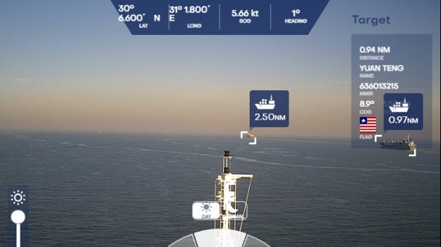
Cameras and AI identify navigation hazards that might be missed by the human eye (NYK)
 
From Maritime Executive  

Efforts are continuing to explore the use of automation, artificial intelligence, and image recognition to improve the navigation and safety of ship operations.
Earlier this year, Japan’s Mitsui O.S.K. Lines demonstrated its efforts are using augmented reality (AR) technology to enhance navigational awareness and now NYK announced that it has begun a trial on the system that can monitor the horizon to recognize dangerous objects that might be within a ship’s range.

NYK working with its strategic research and development subsidiary MTI Co. installed the Automatic Ship Target recognition System developed in Israel by Orca AI on one of NYK’s vessels.
The goal is to verify the detection capability and the contribution the system can make to the role of the lookout on a ship’s bridge.
Working with Orca, NYK also plans to improve the target detection algorithm through the use of data collection and machine learning on the Israeli company’s servers.
During the trial, they are also looking to enhance the recognition rate so that the system could be used to enhance efforts to develop autonomous shipping.
 
Orca’s AI navigation and collision avoidance system is engineered to help create a new lookout support system for vessels by providing improved visibility in difficult conditions, preventing human error, and helping crews make informed decisions.
 
While research has been ongoing on automatic identification by image analysis, according to NYK earlier systems were limited by the ability of cameras to receiving images both at day and night especially with ships exposed the natural elements including rain and wind.
Also, they said that no system could measure the distance from the captured image to the target with a certain degree of accuracy.

The new system NYK explained uses a camera unit that can shoot day and night to automatically recognize ships and targets and measure the distance to them.
Information obtained from navigational equipment, including vessel names, distance, and time when the ship is closest to the target, can be superimposed and displayed in an integrated manner to a tablet or touch-panel monitor display.


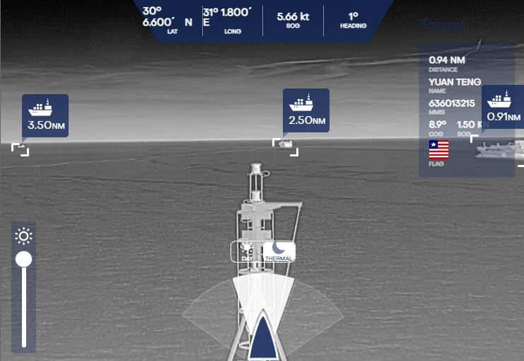
Using infrared cameras the system creates nighttime images (NYK)

Orca AI notes that nearly 4,000 maritime accidents occur annually and are caused they believe by low situational awareness in congested areas, lack of office visibility regarding misses and risk patterns, and insufficient data available for handling potential incidents.

The system is designed to automatically recognizing dangerous objects and other vessels that may be overlooked by the human eye, especially at night and in congested waters.
NYK is seeking to verify this capability noting that the system could be revolutionary in its capabilities to independently recognize small fishing boats and small markers that are not captured by radar and not equipped with AIS.
The system measures the distance to these targets and notifies the person on duty of collision danger.
 

The videos you are about to see were taken from real ships that sailed during the winter with Orca AI
 
The test vessel is equipped with three cameras and three infrared cameras to make nighttime imaging possible.
The system has an angle of view of 120 degrees.
With the video images and data also being relayed to Orca AI’s servers, NYK notes it is possible to monitor the movement of the ship from shore.

In addition, in joint research conducted by NYK and MTI with Orca AI, the system was also installed on domestic vessels to collect information on the Japanese coast, as well as fishing boats, fishing gear, and buoys peculiar to Japan.
This will be used in support of NYK’s efforts with autonomous shipping.

Links :

Sunday, September 12, 2021

Rolex Fastnet Race 2021 : an impressive spectacle

The 49th edition of Rolex Fastnet Race started from Cowes, England, on 8 August, with over 300 yachts setting off into the teeth of a strong westerly.
First held in 1925, the demanding offshore classic has a legendary status in sport. Organized by the Royal Ocean Racing Club, the race has been partnered by Rolex since 2001 and demands the very best in skill, determination and teamwork to succeed.
Divided into seven starting groups, the fleet crossed the Royal Yacht Squadron line and headed west down The Solent, before entering the English Channel.
Competitors are a mix of professional and Corinthians, experienced and newcomers, young and old. With the race finishing in Cherbourg, France for the very first time, the crews face a new twist to the near 100-year-old challenge.