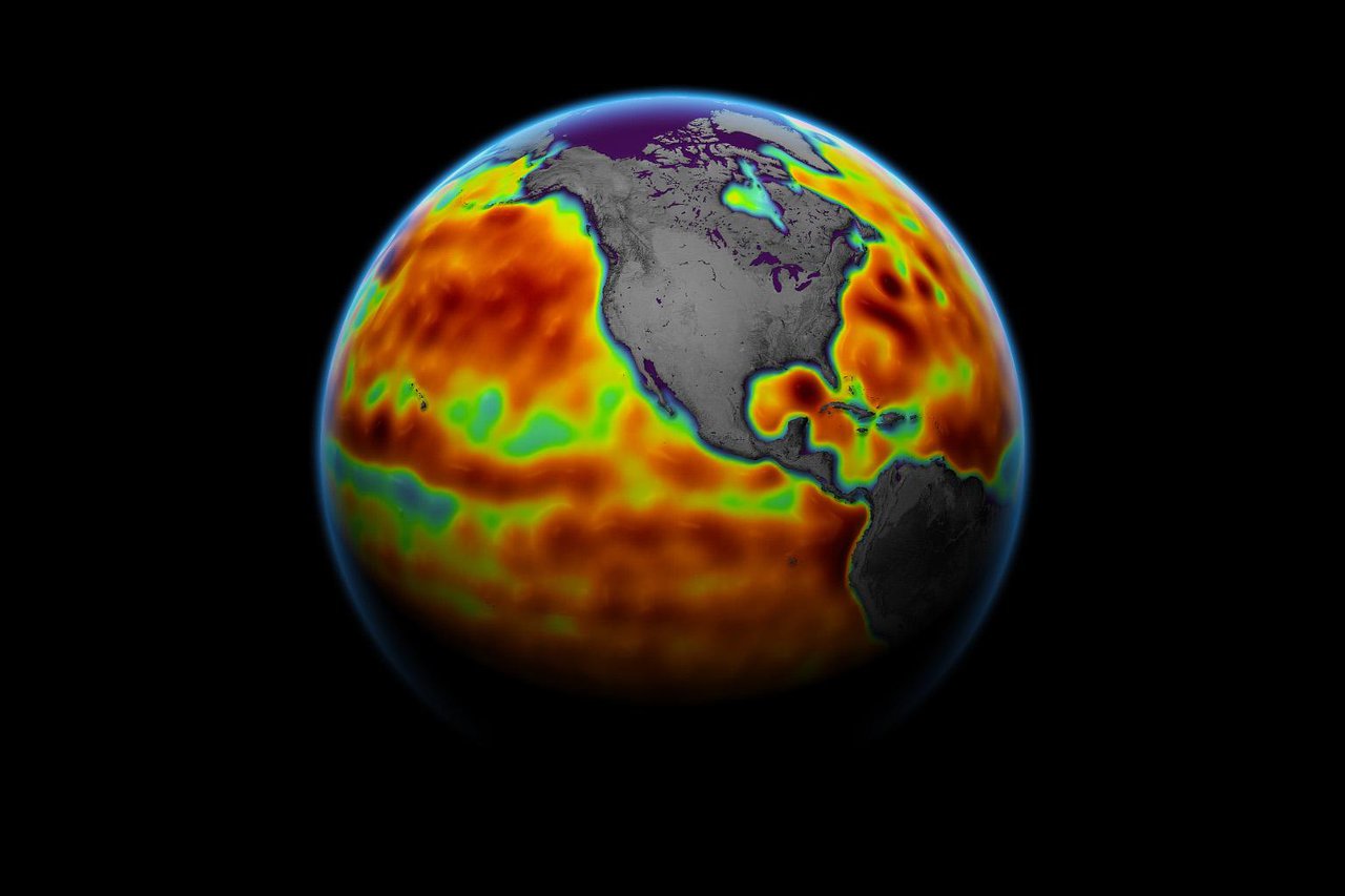
This map shows sea level measured by the Sentinel-6 Michael Freilich satellite from June 5-15. Red areas are regions where sea level is higher than normal, and blue areas indicate areas where it's lower than normal.
Credit: NASA Earth Observatory
From Meteorological Tech. Int by Helen Norman
Sentinel-6 Michael Freilich, a US-European collaboration to measure sea surface height and other key ocean features, such as ocean surface windspeed and wave height, released its first science measurements to users on June 22.
After six months of check-out and calibration in orbit, the Sentinel-6 Michael Freilich satellite, which launched from Vandenberg Air Force Base in California on November 21, 2020, has made two sea surface height data streams available to the public.
One of the sea surface height data streams is accurate to 2.3in (5.8cm) and will be available within hours of when the instruments on board Sentinel-6 Michael Freilich collect it.
A second stream of data, accurate to 1.4in (3.5cm), will be released two days after collection.
According to NASA, the difference in when the products become available balances accuracy with delivery timeliness for tasks like forecasting the weather and helping to monitor the formation of hurricanes.
According to NASA, the difference in when the products become available balances accuracy with delivery timeliness for tasks like forecasting the weather and helping to monitor the formation of hurricanes.
More data sets, which will be accurate to about 1.2in (2.9cm), are slated for distribution later this year and are intended for research activities and climate science including tracking global mean sea level rise.
The satellite collects measurements for about 90% of the world’s oceans.
The satellite collects measurements for about 90% of the world’s oceans.
It is one of two satellites that compose the Copernicus Sentinel-6/Jason-CS (Continuity of Service) mission.
The joint U.S.-European Sentinel-6 Michael Freilich is the next in a line of Earth-observing satellites that will collect the most accurate data yet on sea level and how it changes over time.
With millimeter-scale precision, data from this mission will allow scientists to precisely measure sea surface height and gauge how quickly our oceans are rising.
The Sentinel-6 Michael Freilich satellite is part of the Sentinel-6/Jason-CS mission, a collaboration among NASA, ESA, EUMETSAT, and NOAA
The second satellite, Sentinel-6B, is slated for launch in 2025.
Together, they are the latest in a series of spacecraft starting with TOPEX/Poseidon in 1992 and continuing with the Jason series of satellites that have been gathering precise ocean height measurements for nearly 30 years.
Shortly after launch, Sentinel-6 Michael Freilich moved into position, trailing the current reference sea level satellite Jason-3 by 30 seconds.
Shortly after launch, Sentinel-6 Michael Freilich moved into position, trailing the current reference sea level satellite Jason-3 by 30 seconds.
Scientists and engineers then spent time cross-calibrating the data collected by both satellites to ensure the continuity of measurements between the two.
Once they are assured of the data quality, Sentinel-6 Michael Freilich will then become the primary sea level satellite.
“It’s a relief knowing that the satellite is working and that the data looks good,” said Josh Willis, project scientist at NASA’s Jet Propulsion Laboratory (JPL) in Southern California.
“It’s a relief knowing that the satellite is working and that the data looks good,” said Josh Willis, project scientist at NASA’s Jet Propulsion Laboratory (JPL) in Southern California.
“Several months from now, Sentinel-6 Michael Freilich will take over for its predecessor, Jason-3, and this data release is the first step in that process.”
Sentinel-6/Jason-CS is being jointly developed by the European Space Agency (ESA), EUMETSAT, NASA and NOAA, with funding support from the European Commission and technical support from France’s National Centre for Space Studies.
Sentinel-6/Jason-CS is being jointly developed by the European Space Agency (ESA), EUMETSAT, NASA and NOAA, with funding support from the European Commission and technical support from France’s National Centre for Space Studies.
JPL is contributing three science instruments for each Sentinel-6 satellite: the Advanced Microwave Radiometer, the Global Navigation Satellite System – Radio Occultation, and the Laser Retroreflector Array.
Links :
- NASA : Sentinel-6 Michael Freilich Sea Surface Height / New Ocean Data Flowing In
- GeoGarage blog : New Earth mission will track rising oceans into 2030 / Copernicus Sentinel-6 measuring sea levels using radar altimetry / Jason ocean height mission blasts off / Copernicus Sentinel-3 offers safer navigation at sea / Sentinel's first map of sea-surface 'hills and valleys'
No comments:
Post a Comment