Saturday, March 9, 2019
The Tangaroa Expedition (The Kon-Tiki Expedition) 2012 Documentary
Friday, March 8, 2019
Maiden review – raging seas and sexist squalls
From The Guardian by Peter Bradshaw
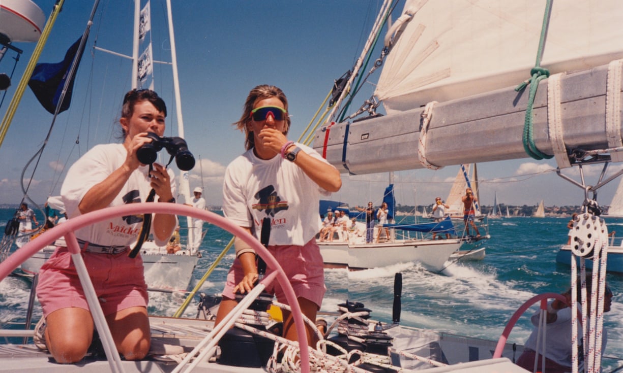
Tracy Edwards is the British sailor who made history in 1989 by skippering the first all-female crew in the Whitbread Round the World yacht race.
This film tells her story and those of her crew members, as they faced sexist squalls from male competitors, who as greying interviewees don’t look best pleased even now to be talking about when and how Tracy beat them.
There was also the press.
The Guardian’s Bob Fisher comes in for some criticism.
Edwards showed a staggering amount of leadership and energy on dry land, as well as at sea, assembling her crew and persuading the King of Jordan to provide vital sponsorship.
The boat was coyly called Maiden, and Alex Holmes’s film also shows how it punningly bore the banner “Maiden Great Britain”.
Their success was also a matter of patriotic pride.
Holmes recreates their adventure, using a lot of home movie footage of her childhood and early life – this appears to be the real thing, although sometimes I wondered if faux Super 8 reconstruction was being used – and also the TV coverage from 1989, with much toe-curling Partridgean commentary from Frank Bough and Fred Dinenage.
At one stage in the race, Edwards cunningly manipulated the paparazzi by getting the entire crew to wear glamorous swimming costumes on deck: they each look surreally like Princess Diana aboard Dodi Fayed’s yacht – but maybe that is simply the era.
There is something that the film doesn’t address as clearly it could have done.
In 1989, Edwards was asked if she was a feminist and she said no – and that she hated the word. It’s probably clear enough what she meant: she just wanted an equal shot at yachting success, just as the then prime minister Margaret Thatcher once wanted an equal shot at political success.
But, given that the present-day Edwards is interviewed at length, Holmes could perhaps have given her another chance to consider that question.
At all events, it pays due homage to Edwards as a courageous pioneer.
Links :
- CNN : Tracy Edwards: 'Maiden was either met with antipathy or aggression'
- DailyMail : Tracy Edwards' bid to save boat that carried her round the world on historic voyage after it is found rotting on an island in the Indian Ocean
- Vanity Fair : “Sailing Was About Freedom”: The Gripping True Story of the Maiden
Thursday, March 7, 2019
Fun fact: GPS uses 10 bits to store the week. That means it runs out... oh heck – April 6, 2019
From The Register by Shaun Nichols
Nav gadgets will be Gah, Properly Screwed if you don't or can't update firmware
Older satnavs and such devices won't be able to use America's Global Positioning System properly after April 6 unless they've been suitably updated or designed to handle a looming epoch rollover.
GPS signals from satellites include a timestamp, needed in part to calculate one's location, that stores the week number using ten binary bits.
That means the week number can have 210 or 1,024 integer values, counting from zero to 1,023 in this case.
Every 1,024 weeks, or roughly every 20 years, the counter rolls over from 1,023 to zero.

The first Saturday in April will mark the end of the 1,024th week, after which the counter (WN = Week Number) will spill over from 1,023 to zero.
The last time the week number overflowed like this was in 1999, nearly two decades on from the first epoch in January 1980.
You can see where this is going.
If devices in use today are not designed or patched to handle this latest rollover, they will revert to an earlier year after that 1,024th week in April, causing attempts to calculate position to potentially fail.
System and navigation data could even be corrupted, we're warned.
"GPS devices with a poorly implemented GPS Time-to-UTC conversion algorithm may provide incorrect UTC following a week number rollover," US Homeland Security explained in its write-up (PDF) of the issue this week.
"Additionally, some GPS devices that calculate the week number value from a device-specific date rather than the start of the current GPS Time Epoch may provide incorrect UTC at some other device-specific date."
As the Reg reader who tipped us off to the shortcoming noted, this could be a significant headache for data centers that use GPS timing for synchronization.
"Decent vendors should have patches. But who has been thinking about this?" our tipster told us.
"This could be a low-key Y2K style bug all over again, but with companies doing less preparation."
Fortunately, devices on sale right now should be prepared for this rollover and handle it gracefully.
Uncle Sam's GPS nerve-center GPS.gov says (PDF) receivers that follow the ICD-200/IS-GPS-200 specification should be able to deal with the week number overflow.
This basically means newer receivers built after, say, 2010 should be fine, provided they follow the specs and notice the rollover.
About 20 years later, on August 21, 1999, the first Week Number Rollover
About 20 years later, on April 6, 2019, the next Week Number Rollover
If it works as normal: brilliant, it's not affected.
Consider yourself forewarned.
GPS.gov also notes that the new CNAV and MNAV message formats will use a 13-bit week number to solve the epoch migraine right up until the planet becomes uninhabitable via climate change or we all blow ourselves up.
Information from Furuno
For impacted GPS, a simple cold start (after resetting the almanacs/ephemerides) may solve the problem as it can permanently crash the GPS.
Note from Furuno : The date specified above is the date in which week number rollover occurs in our products listed above, and the date is independent from the one announced by the US Department of Homeland Security, namely, the 6th of April 2019, which is the date when GPS week number rollover occurs in the GPS as a system per se.
The difference stems from different initial dates of counting week between GPS system and the GPS chipset used in our products.
For devices unprepared for the counter overflow, a firmware upgrade will be necessary to keep the things working properly.
GPS.gov recommends those unsure about their readiness for the turnover, particularly enterprises, should consult the manufacturer of their equipment to make sure they have the proper updates in place.
Links :
- The Next Web : GPS satellites have a little-known ‘Millennium Bug’ problem of their own
- Orolia : The GPS 2019 Week Rollover - What You Need to Know
- Spirent : The GPS Week Number Rollover problem
- XYHT : GPS Week Rollover – Don’t Panic, but...
- The Sync channel blog (2015) : Simulating GPS Week Rollover with the Tria GPS
- UNB : The GPS End-of-Week rollover
- Redit : GPS Date Error as of GPS Week 1000
- DHS published guidelines
- GPS simulators, such as LabSat 3, can be set up to test for issues arising from the GPS Week Rollover event.
- AppStore : GPS Time Converter
- The Register : Brit boffins build 'quantum compass'... say goodbye to those old GPS gizmos, possibly
Wednesday, March 6, 2019
Citizen scientists to help map the reef
From James Cook University by Robin Beaman
James Cook University is calling for volunteers to help map the seafloor around the Great Barrier Reef to better protect the natural icon.
JCU marine geologist Dr Robin Beaman said the Royal Australian Navy does great work mapping the main shipping channels and hazards to navigation such as coral reefs, but there are still many areas that need to be mapped.
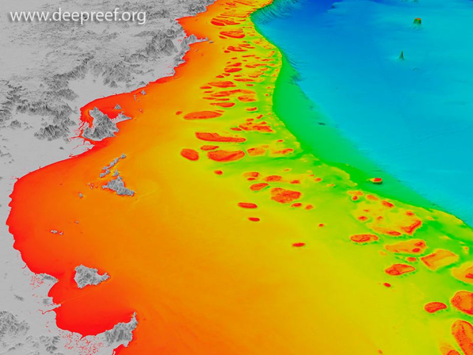
“Around 40% of the vast Great Barrier Reef shelf has been mapped with digital depth soundings using modern equipment, but there are some remote areas lacking any digital depth data,” he said.
Dr Beaman said there was an untapped resource that could be used to help fill the gap.
“Many vessels on the Reef use relatively sophisticated echo sounders, combined with GPS to measure the depth of water and conduct safe navigation. They give a good picture of the seafloor, but the problem is the data are not logged – it just appears in the moment and then is lost,” he said.
In 2018, together with underwater-film specialists Biopixel and their expedition vessel ARGO, the JCU team tested a SmartLog USB data logger, developed by TeamSurv in the UK.
Depth and GPS position data are downloaded through the SmartLog direct to a USB stick.
The Great Barrier Reef Foundation has provided $10,000 to the group to install loggers onto volunteer vessels.
“The SmartLog innovation will enable us to put many more sets of ‘eyes’ in the water to give scientists an accurate picture of the Reef right now and to help map areas of the Great Barrier Reef that we know very little about,” Great Barrier Reef Foundation Managing Director Anna Marsden said.
“It’s a unique opportunity for citizen scientists to easily capture and deliver valuable data to Reef scientists that can be used to inform restoration and adaptation efforts on the Reef.
“Ultimately the Reef will benefit from these types of innovations and the Great Barrier Reef Foundation, with support from our corporate partners, is pleased to be able to help elevate this project to the next level,” she said.
“We have partnered with the Great Barrier Reef Foundation to establish a pool of SmartLog USB data loggers in Cairns. The Citizens of the Great Barrier Reef are also involved, which gives people a role in contributing valuable citizen science data to improve a dataset that helps the Reef,” said Dr Beaman.
He said the group is mainly looking for expedition-style vessels that may travel multiple days to remote parts of the Reef, and that also have GPS navigation and echo sounder systems onboard.
“It’s a simple process to install the SmartLog and the ongoing maintenance just involves collection of the depth data off the USB stick,” he said.
Dr Beaman said the aim is to use the new depth data to improve the accuracy of the 3D depth model of the Great Barrier Reef.
“The shape of the underwater landscape, with its shallow and deeper reefs, pinnacles, holes and channels, influences the path of seawater carrying cooling waters, nutrients and sediment through the reef matrix.
“Detailed knowledge of the seafloor depth is critical for understanding the distribution of seabed habitats, to provide data for coastal inundation forecasting, flood plume modelling and crown-of-thorns starfish control efforts,” he said.
Dr Beaman said the 3D depth data will be also shared with the International Hydrographic Organization’s Data Centre for Digital Bathymetry and the Australian Hydrographic Office.
Volunteers can apply to be part of the project here
Links :
- Hakai Mag : Citizen Science Comes of Age
- Reef Life survey
- Spatial source : High resolution bathymetry data trove released
- GPS world : TCarta to map seafloor around remote Pacific island nation
- GeoGarage blog : Undersea maps reveal Great Barrier Reef in unparalleled detail / This fleet of underwater robots will help citizen ... / Why saving our blue planet may lie in the hands of citizen scientists / NOAA announces launch of crowdsourced ... / Diving enthusiasts could be used to measure ocean ... / Smartboard turns any surfer into an amateur ocean ... / Robot revolution: new generation of cheap drones to ... / Crowdsourcing ocean navigation data / The oceans are in the Cloud / Unlocking the Ocean : smart ocean planning using ... / Beyond charting : nautical information for the 21st ... / Beta test of crowdsourced bathymetry holds promise ... / Beyond charting : nautical information for the 21st ... / Ocean floor to be mapped by 2030 ?
Tuesday, March 5, 2019
Heatwaves sweeping oceans 'like wildfires', scientists reveal
Source: Nature Climate Change | by The New York Times
From The Guardian by Damian Carrington
Extreme temperatures destroy kelp, seagrass and corals – with alarming impacts for humanity
The number of heatwaves affecting the planet’s oceans has increased sharply, scientists have revealed, killing swathes of sea-life like “wildfires that take out huge areas of forest”.
The damage caused in these hotspots is also harmful for humanity, which relies on the oceans for oxygen, food, storm protection and the removal of climate-warming carbon dioxide the atmosphere, they say.
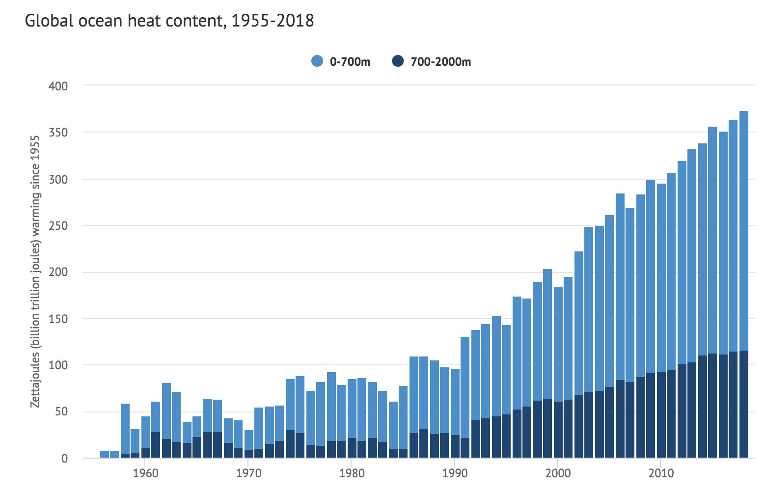
Global warming is gradually increasing the average temperature of the oceans, but the new research is the first systematic global analysis of ocean heatwaves, when temperatures reach extremes for five days or more.
The research found heatwaves are becoming more frequent, prolonged and severe, with the number of heatwave days tripling in the last couple of years studied.
In the longer term, the number of heatwave days jumped by more than 50% in the 30 years to 2016, compared with the period of 1925 to 1954.
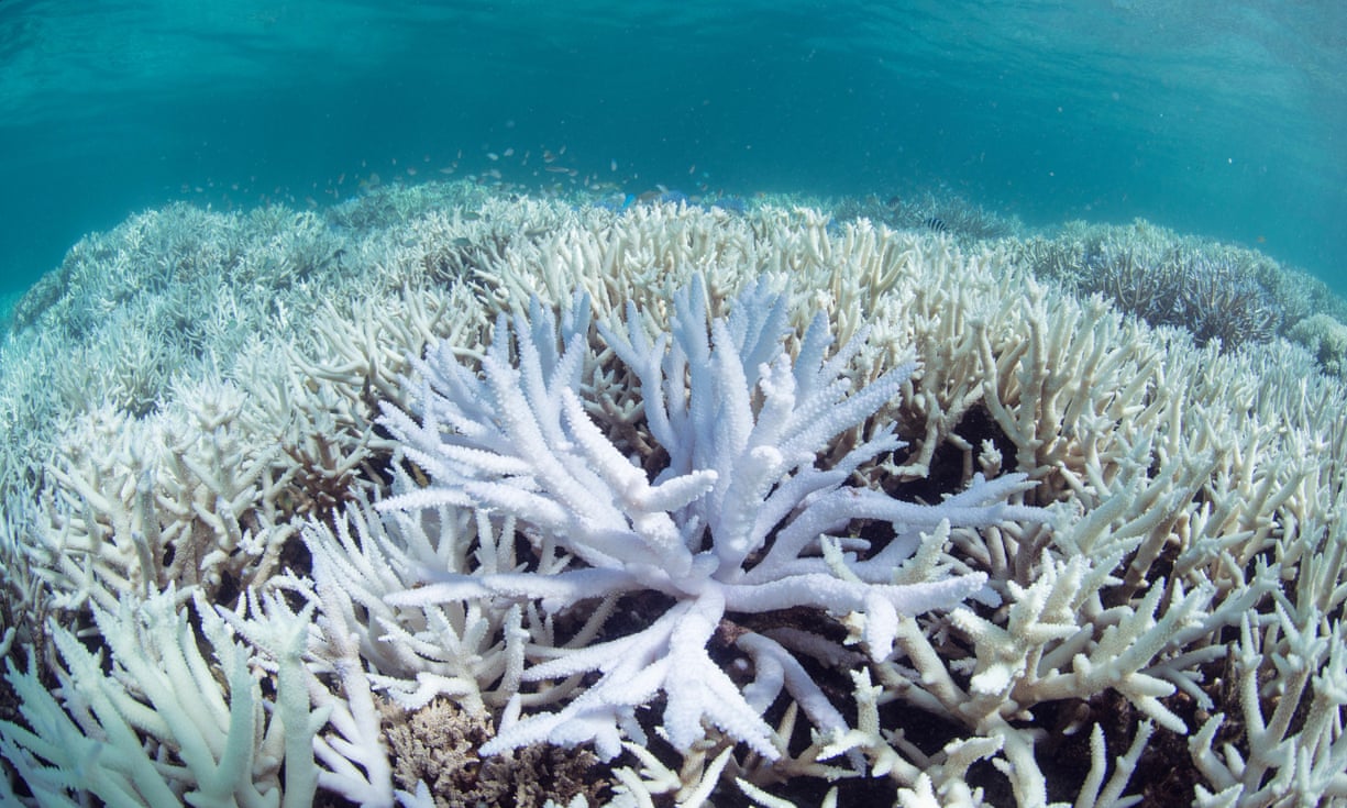
As heatwaves have increased, kelp forests, seagrass meadows and coral reefs have been lost.
These foundation species are critical to life in the ocean.
They provide shelter and food to many others, but have been hit on coasts from California to Australia to Spain.
“You have heatwave-induced wildfires that take out huge areas of forest, but this is happening underwater as well,” said Dan Smale at the Marine Biological Association in Plymouth, UK, who led the research published in Nature Climate Change.
“You see the kelp and seagrasses dying in front of you.
Within weeks or months they are just gone, along hundreds of kilometres of coastline.”
As well as quantifying the increase in heatwaves, the team analysed 116 research papers on eight well-studied marine heatwaves, such as the record-breaking “Ningaloo Niño” that hit Australia in 2011 and the hot “blob” that persisted in the north-east Pacific from 2013 to 2016.
“They have adverse impacts on a wide range of organisms, from plankton to invertebrates, to fish, mammals and seabirds,” Smale said.
The scientists compared the areas where heatwaves have increased most with those areas harbouring rich biodiversity or species already near their temperature limit and those where additional stresses, such as pollution or overfishing, already occur.
This revealed hotspots of harm from the north-east Atlantic to the Caribbean to the western Pacific.
“A lot of ocean systems are being battered by multiple stresses,” Smale said.
The natural ocean cycle of El Niño is a key factor in pushing up temperatures in some parts of the ocean and the effect of global warming on the phenomenon remains uncertain, but the gradual overall heating of the oceans means heatwaves are worse when they strike.
“The starting temperature is much higher, so the absolute temperatures [in a heatwave] are that much higher and more stressful,” said Smale.
Some marine wildlife is mobile and could in theory swim to cooler waters, but ocean heatwaves often strike large areas more rapidly than fish move, he said.
The researchers said ocean heatwaves can have “major socioeconomic and political ramifications”, such as in the north-west Atlantic in 2012, when lobster stocks were dramatically affected, creating tensions across the US-Canada border.
“This [research] makes clear that heatwaves are hitting the ocean all over the world … The ocean, in effect, is spiking a fever,” said Prof Malin Pinsky, at Rutgers University, US, and not part of the team.
“These events are likely to become more extreme and more common in the future unless we can reduce greenhouse gas emissions.”
Dr Éva Plagányi at the Commonwealth Scientific and Industrial Research Organisation (CSIRO) in Australia also likened ocean heatwaves to wildfires.
“Frequent big hits can have long-lasting effects,” she said.
“This study shows that record-breaking events are becoming the new normal.”
ScienceMag : Improved estimates of ocean heat content from 1960 to 2015
The damage global warming is causing to the oceans has also been shown in a series of other scientific papers published in the last week.
Ocean warming has cut sustainable fish catches by 15% to 35% in five regions, including the North Sea and the East China Sea, and 4% globally, according to work published by Pinsky and colleagues.
“We were stunned to find that fisheries around the world have already responded to ocean warming,” he said.
Another study showed that achieving the 2C climate change target set out in the Paris agreement would protect almost 10m tonnes of fish catches each year, worth tens of billions of dollars.
Separate work by Plagányi’s team showed that climate change will reverse the recovery of whales in the Southern Ocean by damaging the krill on which they feed.
“Models predict concerning declines, and even local extinctions by 2100, for Pacific populations of blue and fin whales, and Atlantic and Indian Ocean fin and humpback whales,” they said.
“In the space of one week, scientific publications have underscored that unless we take evasive action, our future oceans will have fewer fish, fewer whales and frequent dramatic shifts in ecological structure will occur, with concerning implications for humans who depend on the ocean,” said Plagányi.
Links :
- The Guardian : Our oceans broke heat records in 2018 and the consequences are catastrophic
- National Geographic : Ocean heat waves are killing underwater life, threatening biodiversity
- LiveScience : Could Earth's Oceans Ever Boil Away?
- NYTimes : Ocean Heat Waves Are Threatening Marine Life / Ocean Warming Is Accelerating Faster Than Thought, New Research Finds
- The Conversation : Suffering in the heat: the rise in marine heatwaves is harming ocean species
- ScienceNews : Oceans that are warming due to climate change yield fewer fish
- PSMag : The ocean gets heat waves too, and they are threatening marine ecosystems
- CNN : What warmer oceans mean for the planet
- Univ. California : Warm seas scatter fish
Monday, March 4, 2019
British nautical maps from century ago help B.C. researchers chart kelp beds
From The Canadian Press by Hina Alam
A serendipitous meeting between a professor and a colleague last year led to a treasure trove of historical maps indicating kelp bed locations off British Columbia's coast, helping experts understand the changes in the ocean's rainforests.
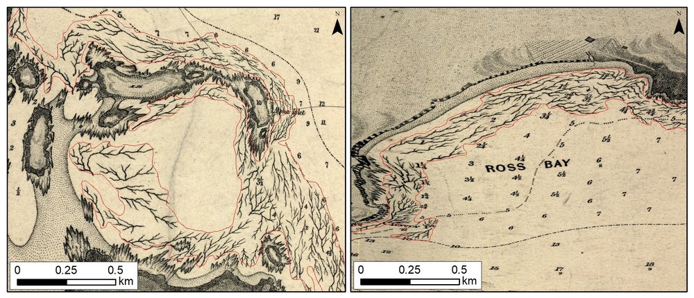
University of Victoria geography Prof. Maycira Costa saw the squiggly lines on the yellowed, hand-drawn map in a picture frame above her colleague's desk.
The wall art was from 1903 and Costa said her co-worker had found it amongst a pile of old maps in someone's office.
"I started to look at the details and then I looked at the area that I know of kelp distribution because we are working there with the modern satellite," she said.
"And I looked at that and said, 'this is kelp distribution.' "
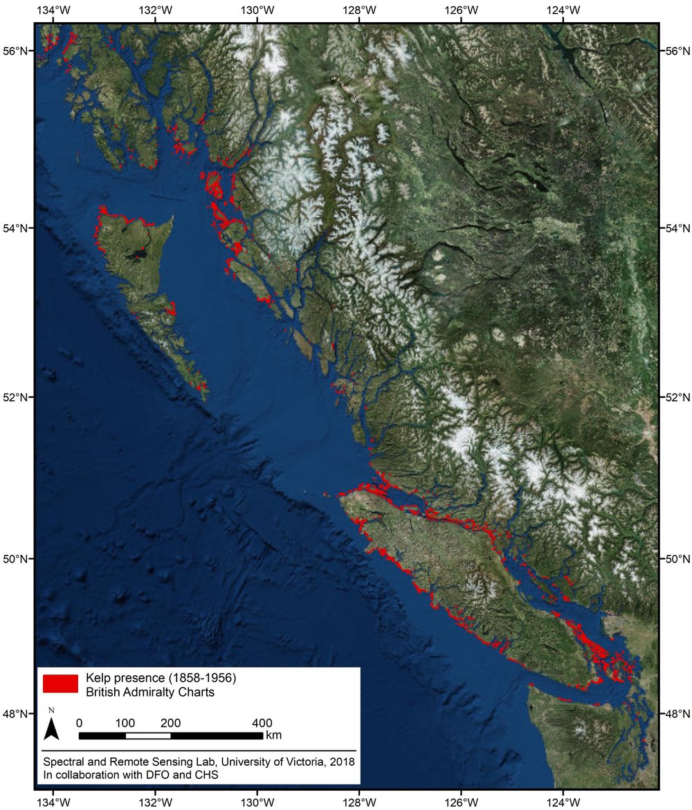
Using those British admiralty charts from 1858 to 1956, Costa and her research team have now created the first historical digital map of B.C.'s coastal kelp forests.
They'll use the maps to further investigate the loss of the kelp beds in research supported by Fisheries and Oceans Canada, Canadian Hydrographic Service and the Pacific Salmon Foundation, she said.
"Kelp was considered a navigational hazard so the British carefully annotated all kelp forests on their charts," Costa said.
"And the historical charts increase our understanding of kelp distribution over time."
The kelp forests are known to be an important habitat for several species along the B.C. coast.
Herring use the kelp beds as a deposit for their eggs, crabs, starfish and juvenile salmon also live in the forests, she said.
Kelp also works as a physical barrier to reduce wave action and cut coastal erosion.
"Kelp are the rainforests of the ocean. And they uptake a lot of carbon from the atmosphere of the ocean," she said.
The province has two types of kelp forests, bull and giant.
They grow from shallow areas to depths of about 20 to 25 metres, Costa said.
One of the growing concerns for kelp is warmer water temperatures but it's unclear if that equates to loss of the forests.
"That's the golden question, right?"
Kelp beds are also vulnerable to coastal pollution and increased turbidity from shoreline development, she said.
Communities monitoring the kelp beds along the B.C. coast have indicated loss, and now with the help of the British maps the team will work to compare the ocean forests, she said.
They'll compare the historical maps with the satellite images from 2002 until 2017, she said.
"A lot of environmental conditions play a role in how successful kelp beds are in specific year. Some areas in the United States documented loss of kelp beds especially when the ocean gets warmer," Costa said.
The next step is to study kelp beds along the entire B.C. coast to better understand how much was lost, she said.
"We now know where they existed about 100 years ago. So what happened recently?"
Links
- The Sqamish Chief : More than 100 years later, naval charts reveal B.C. kelp beds
- SookeNewsMirror : 1858 Naval maps combined with satellite data helps researchers map kelp bed health
- UVIC : Spatial temporal distribution of Nereocyctis Luetkeana (Bull Kelp) and use by juvenile salmonids in the Salish Sea
- Hakai : Mapping Kelp from Space
- GeoGarage blog :The coral reef loss data hidden in old navigational charts
