From ManilaTimes by Rigoberto D. Tiglao
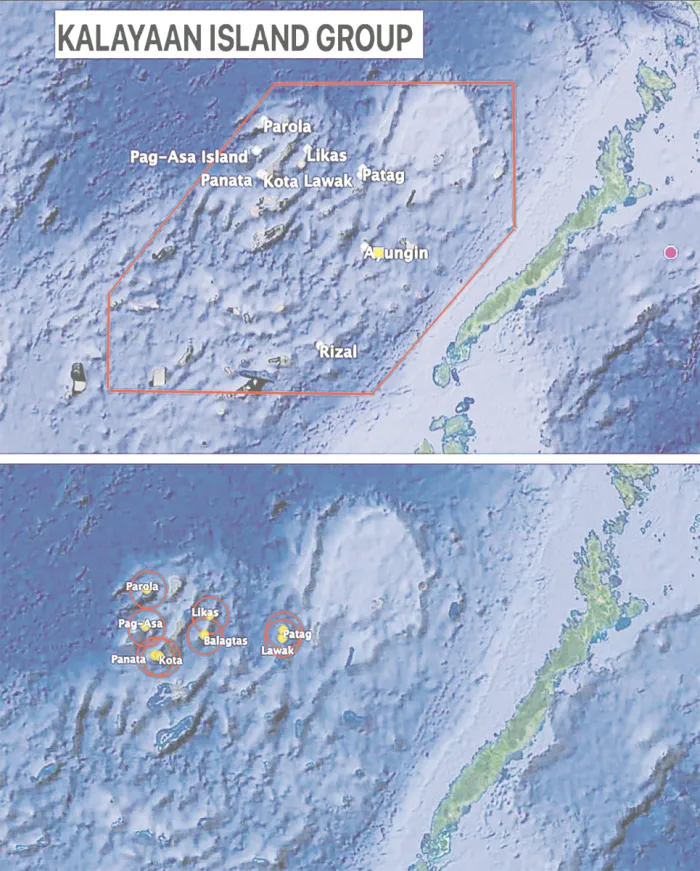
If a new map complies with the 2016 arbitration decision, we lose the KIG’s (hexagon in red) 53,00 sq km and have only 14,000 sq km of the islands’ area and their 12 nautical-mile (red circles) territorial sea.
Last of two parts
BLAME it on the 2016 arbitral ruling on the Aquino III government’s suit against China, made by an ad hoc panel based on the United Nations Convention on the Law of the Sea (Unclos).
The ruling, which President Ferdinand Marcos Jr. and the Foreign Affairs department have swooned over in ignorance as a victory of the international rule of law, was in reality so disastrous for our interests.
First, the suit provoked China, as soon as the suit was filed in 2012, to build artificial islands on its seven reefs in the Spratlys, despite its unprecedented, unbelievable cost of at least $30 billion, rivaling in cost the superpower’s biggest infrastructure, the Three Gorges Dam.
Second, if the Philippines complies with the arbitral ruling, it will drastically reduce our sovereign territory and maritime areas in the Spratlys so much so that any current administration would likely put off such a task.
The ruling indeed declared China’s nine-dashed line encompassing a huge part of the South China Sea — which it had never claimed marks its territory — as violating the Unclos.
But it also declared illegal the six solid lines forming the hexagon that the strongman Marcos decreed in 1978 as marking our sovereign territory (including all the maritime features and waters there), which he called the Kalayaan Island Group (KIG).
Under the arbitral ruling, we’re left with only the nine islands and rocks we have occupied since the early 1970s. Including their territorial waters (12 nautical miles seaward), these consist of 14,000 square kilometers, or just 26 percent of the 53,000 sq km of the KIG box under Presidential Decree 1596 of
What president would be willing to be accused of losing such a huge territory, which will be so conspicuous in a new map that complies with the arbitral ruling? Better for his politics to shelve this task of having an updated map of the Republic.
The arbitral decision also ruled that “none of the Spratly Islands is entitled to an exclusive economic zone (EEZ)” but at most to a territorial sea of 12 nautical miles.
PH only
The big, big problem for us, which emphasizes the utter stupidity of the Aquino III regime that filed the suit, is that it is only the Philippines which agreed to be bound by the tribunal’s decision.

Indeed, as an arbitration ruling, it would be just as irrational to claim it binds China, which refused to participate in the process, as well as other countries, as to argue that the Unclos interpretation cited in the arbitration ruling that bound Bangladesh and India on the maritime boundary in the Bay of Bengal also binds
To respond to a Philippine move in the future to make official the new arbitration-based map by depositing it at the United Nations, China and Vietnam will declare their EEZs of 200 nautical miles in the features they occupy in the Spratlys (7 for the former, 21 for the latter), claiming they are not bound by the Philippines v. China arbitral ruling.
The result would be 28 overlapping EEZs, with the Philippines’ tiny territorial seas all in the middle of Chinese and Vietnamese EEZs.
Three would even hit or go past the Palawan shorelines.
This would mean that minutes after the Philippine Navy or Coast Guard vessels would have left their ports in Palawan to visit our islands in the Kalayaan Island Group, the People’s Liberation Army would be interdicting them, claiming they are entering the Chinese EEZ without the required permissions. People would condemn the president who issued the new map.
We would have a third big problem if an official map is issued that complies with the arbitral ruling and with Republic Act (RA) 9522 of 2009, or our old baselines law.
Scarborough
Under this law, Bajo de Masinloc, also known as Scarborough Shoal, is defined as part of Philippine sovereignty as a “regime of islands,” defined by Unclos as an assemblage of islands close to each other over which a state claims sovereignty, regardless of distance from a country’s mainland.
Baselines under Unclos are points in a state’s land territory, from which is measured its territorial sea (12 nautical miles seaward) and EEZ (200 nautical miles).
China deposited its baselines document in December 2024 with the UN, a step toward having international recognition of its sovereignty claim over the shoal.
Only the Philippines formally protested China’s move.
However, its crucial blunder is that to this day, it has not declared its baselines for Scarborough, therefore it has not deposited such a document with the UN, which should have sought international backing for its claim.
The pattern of China’s actions in the South China Sea dispute is that it always undertakes its move after a provocation, or its interpretation that its sovereignty is being challenged in actual action.
Scarborough’s theoretical (i.e., still undeclared by China) 12-nautical-mile territorial sea (red,small circle) and the 200-nautical-mile EEZ.
Huanyan Dao
In September 2025, China declared Huanyan Dao a national nature reserve, ostensibly for coral reef protection.

This move is widely seen as a strategic power play to assert control, which it certainly is.
However, the move fell short of a Chinese project to make it into an artificial island complete with facilities that its navy and air force could use, as it did in the nine reefs in the Spratlys that it has occupied since the 1970s.
- ChinaMil : Philippines' claim on Huangyan Dao completely untenable
- People.cn : Things to know about Huangyan Dao national nature reserve
- ChinaDaily : The Philippines' South China Sea claims based on fabricated evidence
- GeoGarage blog : The Murillo hoax
No comments:
Post a Comment