Saturday, April 13, 2019

Nautical chart of the Port of Alexandria, Egypt

This is a rare French nautical chart or map of Alexandria, Egypt dating to 1867 (updated to 1882). Prepared by the French Depot des Cartes et Plans de la Marine, this map offers extraordinary detail both inland and at sea.
In the harbor there are countless depth soundings in meters, sailing notations, and references to shoals, lights, and navigational points.
Inland there is a wealth of information regarding the city proper, important buildings, topography, gardens, streets, palaces, walled fortifications, and surrounding villages.
Detailed textual sailing instructions in the lower right quadrant. 
original source : Geographicus

2019 (UKHO map)

Friday, April 12, 2019

Canada CHS layer update in the GeoGarage platform

 61 nautical raster charts updated & 1 new chart added

Sea anemones are eating the plastic microfibers that your laundry is releasing into the oceans

New research shines the spotlight on a new plastic pollution menace -- microfibers.
By 2050, the World Economic Forum predicts that the amount of plastic in the oceans will outweigh ALL the fish.
When you hear “plastic” pollution, you might picture six-pack rings wrapped around seagulls or beaches littered with plastic bottles.
But now, researchers are discovering a new menace -- microfibers.
They’re tiny strands of synthetic fibers.

 From Forbes by Priya Shukla

Approximately 60% of the clothing we wear consists of synthetic fibers made from plastic including acrylic, nylon, and polyester.
These ubiquitous fibers are used in everything from moisture-wicking athletic pants to insulated winter coats.
While convenient, thousands of these plastic microscopic fibers ("microfibers") - which are too small to be caught by a dryer lint trap - are often shed when the clothes are washed, causing them to end up in our waterways and add to plastic pollution in the oceans.

"Microfibers are a sub-category of microplastics that originate from items like clothes, carpets, furniture, fishing line and fishing nets, and cigarette butts, " says Nicholas Mallos, director of Ocean Conservancy’s Trash Free Seas® program, "They are essentially any synthetic fiber that is less than 5 millimeters in size."

Because nearly 1 million of these fibers are released when polyester fleece is washed, outdoor clothing brand Patagonia has committed to researching microplastic pollution in the ocean.
And, a new study shows that sea anemones - which are close relatives of corals - are taking up these microfibers.

"[Because] the shape of microfibers differ from other types of microplastic the effects ...
[on] marine organisms may also be different,"says Dr. Manoela Romanó de Orte, a postdoctoral researcher at the Carnegie Institution for Science and lead author of this study, "We will only be able to understand these differences if we perform studies with microfibers separately from microplastics."

Fluorescent plastic microfibers that have been ingested by a bleached sea anemone, Aiptasia pallida.
Dr. Romanó de Orte

Like corals, when anemones become stressed from unusually warm temperatures, they can also become bleached, lose their coloration, and evict the microscopic algae they harbor that provide them with nutrients.
In this study, researchers fed bleached and healthy anemones nylon, polyester, and polypropylene microfibers alone and intermixed with brine shrimp.

According to Dr. Romanó de Orte, "Since plastic pollution is not happening alone, but together with other threats such as global climate change, studying the interaction between these two stresses is important to understand the real-world challenges that coral reefs face."

Dr. Romanó de Orte

When combined with brine shrimp, 80% of bleached and healthy anemones ingested all of the different microfibers.
However, once the microfibers were ingested, healthy anemones were able to eject the microfibers from their bodies more quickly than their bleached counterparts.
This suggests that warming oceans may reduce anemones' or corals' abilities to expel microfibers from their bodies.

"We know that filters on washing machines are highly effective (>80%) at preventing fibers from leaking into the wastewater stream and ultimately the marine environment," says Mallos, "We still need to find ways to divert and capture microfibers outside of the laundry cycle, at the production phase ... and we should also work to make materials that shed less."

Links :

Thursday, April 11, 2019

This is what a planet-wide network of ocean sanctuaries could look like

Current protected area of world's oceans

Future marine sanctuaries?
Projected protection zones in world's oceans by 2030
see Interactive map
Images: Greenpeace

From World Economic Forum
 
What comes to mind when you think of the high seas?
Pirates, whales, giant squid and great white sharks?

Long the subject of stories and myths, life in the oceans beyond territorial waters is far from picture perfect.
Under threat from climate change, acidification, overfishing, pollution and deep-sea mining, the area is now a focus for international scientists, who want to limit exploitation with ocean sanctuaries.

“Extraordinary losses of seabirds, turtles, sharks and marine mammals reveal a broken governance system,” said Professor Callum Roberts, a marine conservation biologist at the University of York.
“Protected areas could be rolled out across international waters to create a net of protection that will help save species from extinction and help them survive in our fast-changing world.”

The researchers broke down the global oceans – which cover almost half the planet – and mapped the distribution of 458 different conservation features, including wildlife and habitats.
They considered hundreds of scenarios for what a planet-wide network of ocean sanctuaries could look like, before putting together a plan for at least 30% to become ocean sanctuaries.


The resulting report, titled 30×30: A Blueprint For Ocean Protection, is a collaboration between the University of York, the University of Oxford and Greenpeace.
It comes as the United Nations prepares to vote on an international legally binding instrument for the conservation and sustainable use of marine biological diversity of areas beyond national jurisdiction.

It matters, not only for the protection and preservation of our ecosystems, but also because marine life captures carbon at the surface of the high seas and stores it deep below, a mechanism that if lost would result in our atmosphere containing 50% more carbon dioxide.

At this year’s World Economic Forum Annual Meeting in Davos, the Friends of Ocean Action brought together entrepreneurs, innovators and scientists to discuss high-impact, large-scale solutions that could make the seas healthier.

Work like this, and the 30% plan, could help safeguard the future.
“What’s so exciting about this research is that it shows that it is entirely possible to design and create a robust, planet-wide network of ocean sanctuaries,” said Dr Sandra Schoettner from Greenpeace’s Protect the Oceans campaign.
“These wouldn’t just be lines drawn on a map, but a coherent, interconnected chain of protection encompassing wildlife hotspots, migration corridors and critical ecosystems.”


Links :

A surprising surge at Vavilov Ice Cap

Video compiled by Whyjay Zheng using LANDSAT imagery by NASA/USGS

From NASA by Adam Voilan

Glaciologists generally classify glaciers into two major types.
In temperate areas, where summers are relatively warm and plenty of snow falls, warm-based glaciers dominate.
This type slides easily, often slipping a few kilometers each year because water lubricates the ground and the base of the glacier.
In contrast, cold-based glaciers dominate in polar deserts—the cold, high-latitude areas that receive little snow or rain.
This type of ice generally stays fixed in place, rarely moving more than a few meters per year.
When a cold-based glacier in the Russian High Arctic began sliding at a breakneck pace in 2013, University of Colorado Boulder glaciologist Michael Willis was mystified.

After moving quite slowly for decades, the outlet glacier of Vavilov Ice Cap began sliding dozens of times faster than is typical.
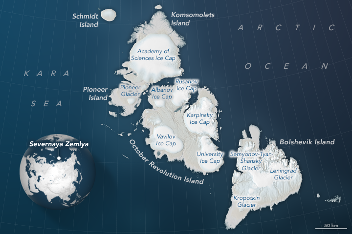
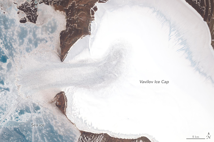
The ice moved fast enough for the fan-shaped edge of the glacier to protrude from an ice cap on October Revolution Island and spread widely across the Kara Sea.
“The fact that an apparently stable, cold-based glacier suddenly went from moving 20 meters per year to 20 meters per day was extremely unusual, perhaps unprecedented,” said Willis.
“The numbers here are simply nuts.
Before this happened, as far as I knew, cold-based glaciers simply didn’t do that...couldn’t do that.”


Landsat satellites have been collecting imagery of the glacier for decades.
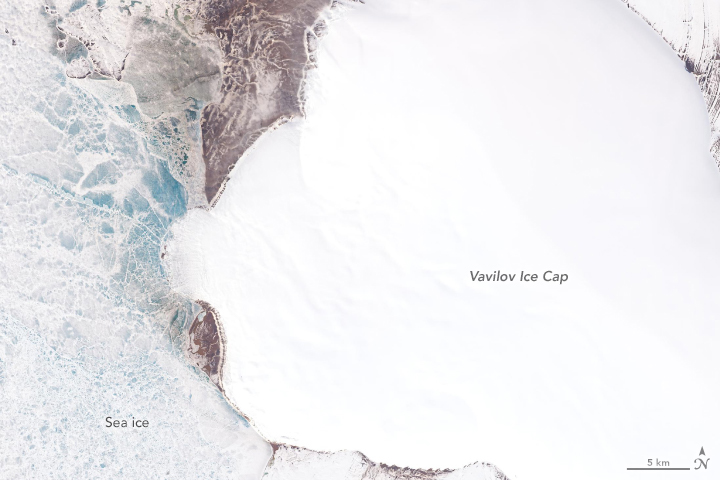
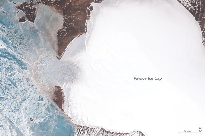
A time-lapse video, which begins with imagery acquired in 1985, showed the terminus creeping forward between 2000 and 2013, but at a modest pace—just enough for a tongue of ice to begin pushing into the Kara Sea.
After 2013, the glacier sprang forward, accelerating rapidly.
By 2018, the glacier’s ice shelf (where the tongue stretches over the water) had more than doubled.
Meanwhile on land, the ice had thinned noticeably, particularly around the edges.
(Note that in the images above, the blue areas in the Kara Sea are sea ice, not glacial ice.)
Willis and his colleagues are still piecing together what triggered such a dramatic surge.
They suspect that marine sediments immediately offshore are unusually slippery, perhaps containing clay.
Also, water must have somehow found its way under the land-based part of the glacier, reducing friction and priming the ice to slide.

July 1, 2013

June 18, 2015

June 24, 2018
NASA Earth Observatory images by Lauren Dauphin and Joshua Stevens, using Landsat data from the U.S. Geological Survey and topographic information from the ArcticDEM Project at the Polar Geospatial Center, University of Minnesota.

Observations from several satellites suggests that the northern and southern edges of the glacial tongue are grounded on the sea bottom, while the middle is probably floating, another factor that has made it easier for ice to push forward at a rapid rate.
The sudden surge raises questions about the future of Vavilov Ice Cap.
Though the glacier’s pace slowed somewhat in 2018, it has sped up again in 2019.
“If this continues, we could be witnessing the demise of this ice cap,” said Willis.
“Already, Vavilov has thinned enough that snow has stopped accumulating on its upper reaches, and it is a small ice cap in the first place.”
Hundreds of cold-based glaciers line the coasts of Greenland, Antarctica, and islands in the high Arctic.
Together they cover hundreds of thousands of square kilometers of land.
The events at Vavilov suggest that these glaciers may be less stable and resilient and more capable of collapsing and affecting sea level.
“This event has forced us to rethink how cold-based glaciers work,” Willis said.
“It may be that they can respond more quickly to warming climate or changes at their bases than we have thought.”

Links :

Monday, April 8, 2019

China’s claims on the South China Sea are a warning to Europe

Chinese warships in the South China Sea. Beijing's claims of 'historical rights' to vast territorial waters run contrary to the UN Convention on the Law of the Sea
© AFP

From Financial Times by Yasunori Nakayama

While the European Commission is wrestling over China’s efforts to draw European countries into joining its Belt and Road Initiative, a similar set of issues deserve attention on the other side of the world.
President Xi Jinping secured deals involving several ports in Italy during an official visit last month, giving China a key maritime and transcontinental gateway into Europe.
Meanwhile, China has been conducting legal warfare to consolidate its excessive claims to vast sections of the South China Sea, one of the world’s busiest waterways.
China’s latest investments in Trieste, on the northern Adriatic Sea, and Genoa, Italy’s biggest seaport, add to a growing network of seaports and maritime trade routes that include stakes in the Greek port of Piraeus, run by Chinese shipping giant Cosco.
In Israel, China is building two ports.
It has opened its first naval base overseas in Djibouti in the Horn of Africa, strategically situated in sea lanes between Asia-Europe trade routes.
A few deals here, a few deals there, and it’s often so low key that many fail to grab attention.
It’s only when the dots are joined that the wider picture emerges.
In the case of China’s ambition to become a global naval superpower, there are important political and security implications for Europe and the US.
The creeping expansion of China’s presence in the South China Sea should provide a sobering lesson for Europe.
For decades, there have been overlapping claims to the islands, reefs and underwater shoals of the South China Sea involving China, Vietnam, the Philippines, Taiwan, Malaysia and Brunei.
China claims more than 80 per cent of the sea, which is home to over 200 specks of land and vast gas and oil reserves, arguing that it has “historic rights” over the area under customary international law.
It insists that these rights supersede the rights enjoyed by other coastal countries under the United Nations Convention on the Law of the Sea (Unclos).

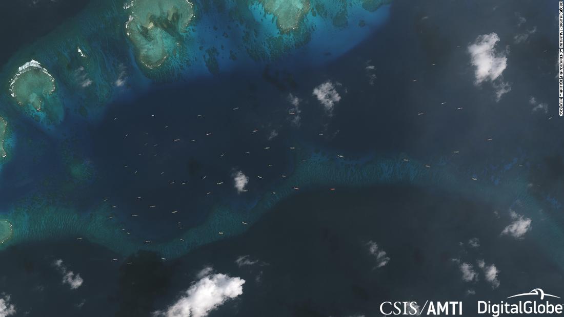
 A satellite photo from December 20, 2018, showing the fleet of Chinese ships in the area around Thitu Island.
see : AMTI's island tracker

In 2016, the South China Sea Arbitration ruled that the nine-dash line — a geographical marker China invoked to assert its claims — was contrary to the Unclos.
This, however, has not dimmed China’s ambitions.
Since then, Beijing has constructed military installations on artificial islands it has created in disputed waters, populating them with advanced surface-to-air missiles and airfields that can support bombers.
As of last week, since the start of this year, some 200 Chinese ships, believed to be part of China’s sea militia, have been spotted near the Philippine-occupied Thitu Island, fuelling further tensions.
We should pay close attention to China’s practice of declaring straight baselines around outlying archipelagos.
In 1996, it declared that it was adopting straight baselines around the outer islands of the Paracel Islands chain.
It has continued to claim these rights, despite the arbitration panel’s decision that it was not entitled to do so, chiefly because China is not recognised by the Unclos as an archipelagic state.
Nonetheless, the recent publication of The South China Sea Arbitration Awards: A Critical Study by the Chinese Society of International Law has raised the stakes further, by arguing that “the regime of continental states’ outlying archipelagos is not addressed by the convention [on the law of the sea]”.
By this line of thinking, the study seeks to claim that “customary” international law instead allows continental states to draw and claim straight baselines to offshore archipelagos.
This claim has significant implications for the Spratly Islands.
Named after the British whaling captain who sighted them in 1843, the Spratlys are one of the major archipelagos in the South China Sea, scattered over a wide area.
If China declared straight baselines around the Spratly Islands, vast sections of the South China Sea would become Chinese internal waters, and China would be able to restrict the navigation of foreign vessels.

A third of the world’s shipping — trillions of dollars worth of international trade — passes through the South China Sea, so restricting the right of free passage would have a significant effect on global commerce.
In fact, the Chinese Society of International Law study suggests that China may try to enforce a rule that freedom of navigation could be based on the “self-restraint or custom” of coastal states.

 source : Lowy Institute

The dispute has drawn the attention of the Trump administration.
The US Navy has stepped up freedom of navigation operations in the region, challenging China’s claims in the sea.
Britain also has shown its willingness to commit itself to protecting high seas freedom in the South China Sea: on February 11, Gavin Williamson, the UK defence secretary, said it would deploy its new flagship carrier, the HMS Queen Elizabeth, to the South China Sea.
Beijing continues to assert that it adheres to the Unclos and respects the rule of law at sea.
However, there are reasons to doubt whether this is the case.
In a conference in Kyoto in March, Paul Reichler, chief counsel for the Philippines in the South China Sea case, noted that “from Japan’s perspective, but it would be a perspective that I share, China has adopted some extremely self-serving and almost implausible interpretations of Unclos”. Established rules and structures of the international maritime system are increasingly under threat.
During a symposium in London in February, Professor Atsuko Kanehara of Sophia University, Tokyo, noted that the way in which international law regarding historic rights is applied would be critical in maintaining the validity of the Unclos.
Chinese claims to rights based on a broad spectrum of customary international law run the risk of severely impairing the international maritime legal order.
As we seek ways to address all attempts to alter the status quo by force, upholding the rule of law on maritime affairs is a crucial first step.

Links :