
Illustration of the Nina, Pinta and Santa Maria, the fleet of Christopher Columbus.
Bettmann/Getty Images
Bettmann/Getty Images
From Time by David Abulafia author of The Boundless Sea: A Human History of the Oceans
(with additional content from WP by Max Fisher)
One of humanity’s greatest achievements has been mastering routes across the world’s oceans.
Communities separated by thousands of miles have been brought into contact and religious ideas have spread across the waters, while artistic creativity has been spurred on by the experience of seeing the products of different civilizations.
Customs have been decisively altered by the movement of ships across the oceans.
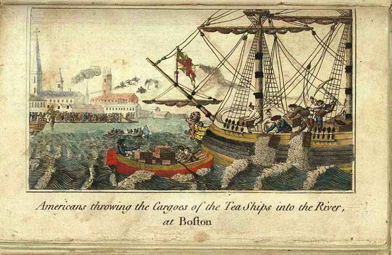
No one drank tea in medieval Europe, but once contact had been made with the tea-drinking Chinese, tea became the obsession of millions of people from Sweden to the United States — tea is part of the founding history of the United States, as the Boston Tea Party reveals.
We tend to think that the opening of the oceans was the work of the great explorers, especially the 15th century pioneers who edged their way through uncharted waters to southern Africa, the Indian Ocean and the spice lands of the Indies.
These were sailors such as Christopher Columbus, who chanced upon unsuspected lands that blocked the expected sea route from Europe to China and Japan.
But while these men did give the Age of Discovery its name, they didn’t start the exploration of the world’s oceans — and there were also scores of merchants who followed in their wake, taking full advantage of new knowledge about the open ocean to develop trade links across the world that were the precursors of modern globalization.
These were the people who really mastered the oceans and brought the continents into contact.

Already around 2500 BC, merchants were setting out from what is now Iraq, the seat of the ancient Sumerian civilization, carrying silver ingots to India, which was the seat of another even more mysterious civilization, that of the Indus Valley.
En route, they acquired copper from Oman and brought precious objects such as carnelian and lapis lazuli from India.
Accumulating and re-investing profits, they were the first capitalists.
The Indian Ocean became one of the great channels of trade between nations.
Greek merchants from Egypt exploited the monsoon winds to ensure a swift passage to south India.
The Chinese emperors tended to discourage uncontrolled trade, though prohibitions often did more to provoke traders into finding ways around the rules.
Early compasses were used for feng shui, not navigation.
But in the 12th century AD, when the coasts of China were open to the world, Hangzhou was at the peak of its prosperity.
Later, Marco Polo would bear witness to this vigorous commercial life, with its use of paper money and its links to Java and beyond.
And in the open Pacific, hundreds of scattered islands from Hawaii to Easter Island were settled over many centuries — the Polynesians only reached New Zealand around AD 1300.
Even without written records, the Polynesians transmitted exact knowledge of how to sail these apparently boundless waters from generation to generation.
By 1500 AD, the Portuguese had begun to show interest in what the Atlantic might offer.
That interest had resulted in the settlement of uninhabited islands including Madeira, which began to export phenomenal quantities of sugar.
Portugal also founded the slave trade, bringing captives from West Africa to Europe and later to the Americas without consideration for their humanity

When Spain and Portugal dominated the world
This map shows the Spanish and Portuguese empires at their height.
They didn't hold all of this territory concurrently, but they were most powerful from 1580 to 1640, when they were politically unified.
Portugal would later pick up more territory in Africa, not shown on the map.
We often forget that Spain controlled big parts of Europe, in Italy and the Netherlands.
In the Middle Ages, Spain and Portugal were so powerful that they signed a set of treaties literally dividing up the globe between them.
They became so rich so quickly that their trade with the Ottoman Empire, perhaps the other great imperial power of the time, filled the Ottoman economy with more gold than it could handle and plunged it economy into an inflationary crisis so severe that the empire never fully recovered.
They still depended on the resources and supply lines of the inhabitants of the lands they visited, even as they created routes across the entire globe that brought Chinese porcelain and silk from Manila through Mexico to Havana and then on to Spain, or through Macao and then on past southern Africa all the way to Europe.
A symbol of these global links was the porcelain produced in China bearing the words E PLURIBUS UNUM made specially for the American market.

Major shipping routes in the colonial era
This map shows British, Dutch and Spanish shipping routes from 1750 to 1800.
It's been created from newly digitized logbooks of European ships during this period.
(Unfortunately, the French data is not shown.)
These lines are the contours of empire and of European colonialism, yes, but they're also the first intimations of the global trade and transportation system that are still with us today.
This was the flattening of the world, for better and for worse.
source : CLIWOC , image James Cheshire
source : CLIWOC , image James Cheshire
Since then, the oceans have only continued to tie the world together — most dramatically when new routes were literally carved out, with the building of the Suez Canal in the 19th century and the opening of the Panama Canal in 1914.
The first goods to pass through the Panama Canal consisted of a cargo of tinned pineapples from Hawaii.
The Pacific and the Atlantic were more closely tied together than ever before.

Americans have mostly come around to accept that, despite what our grade school teachers may have told us, Europeans did not "discover" America; the original arrivals had done that 15,000 years earlier.
But Europeans did discover lots of land that had never been before seen by human eyes.
You can, embedded in this map, see successive waves of European exploration: first the Portuguese, then the Spanish, then the British and much later the Americans.
The map's creator, the always-insightful Bill Rankin, writes, "this map particularly underscores the maritime expertise of Pacific Islanders.
Unlike the islands of the Atlantic and Indian Oceans, nearly all of the Pacific was settled by the 14th century."
In the 21st century, however, new factors have changed entirely the way goods are carried across the seas, even though over 90% of world trade is carried on ships.
Containerization means that goods can be loaded in Chicago and unloaded in Warsaw without having to be unloaded at ports.
The great port cities of the world have been replaced by automated docks full of gantries and cranes.
Container ships carry many thousands of containers.

Map lets you visualize shipping traffic around the world
Interactive data visualization illustrates the incredible number of ships criss-crossing the world's oceans at any given time
Interactive data visualization illustrates the incredible number of ships criss-crossing the world's oceans at any given time
source : shipmap.org
And yet, through trade and cultural exchange, the seas continue to connect even the most distant lands.
Links :
- GeoGarage blog : The great explorers of Islam / A 500-year-old map used by Columbus ... /A map that may have led Columbus to ... / Colombus and the Piri Reis map of 1513 / The Genoese brothers who disappeared ... / Venetian navigators : the voyages of the Zen ... / How 16th-century European mapmakers ... / Were Portuguese explorers the first ...
Big Think : Columbus was neither the first nor the nicest. But his voyage was the most important
ReplyDelete