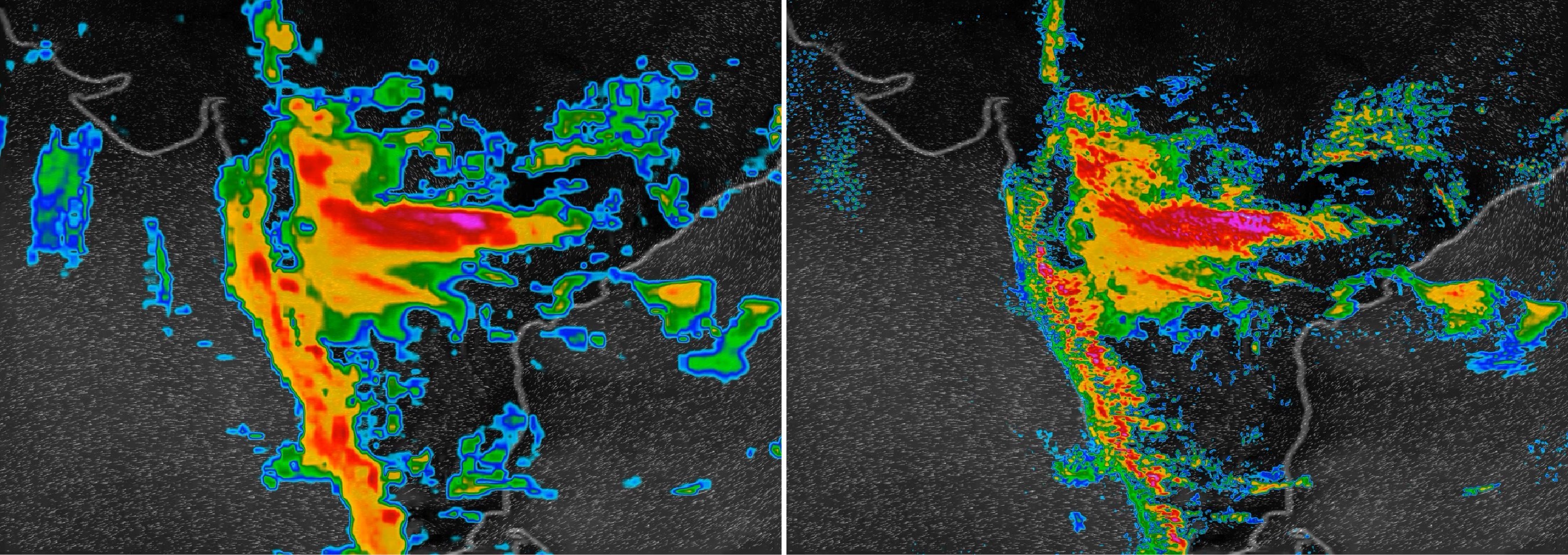
An August 2018 monsoon in India, shown at left by the best current weather model that operates at 13-kilometer resolution.
At right, the new IBM Global High-Resolution Atmospheric Forecasting System (GRAF) operates at 3-km resolution and updates 6 to 12 times more often.
Credit: IBM
From PRnewswireNew global weather forecasting system can crowdsource data from millions of previously untapped sources and will provide accurate, rapidly updated local forecasts worldwide
IBM and its subsidiary The Weather Company today unveiled a powerful new global weather forecasting system that will provide the most accurate local weather forecasts ever seen worldwide.
The new IBM Global High-Resolution Atmospheric Forecasting System (GRAF) will be the first hourly-updating commercial weather system that is able to predict something as small as thunderstorms globally.

Compared to existing models, it will provide a nearly 200% improvement in forecasting resolution for much of the globe (from 12 to 3 sq km).
It will be available later this year.
GRAF uses advanced IBM POWER9-based supercomputers, crowdsourced data from millions of sensors worldwide, and in-flight data to create more localized, more accurate views of weather globally.

Ginny Rometteti talks about the new weather forecasting system
IBM Chairman and CEO Ginni Rometty announced GRAF at CES 2019 in Las Vegas.
"Today, weather forecasts around the world are not created equal, so we are changing that," said Cameron Clayton, general manager of Watson Media and Weather for IBM.
"Weather influences what people do day-to-day and is arguably the most important external swing factor in business performance.
As extreme weather becomes more common, our new weather system will ensure every person and organization around the world has access to more accurate, more finely-tuned weather forecasts."
Simulation of Hurricane Katrina at 3km resolution
A regional climate model simulation of Hurricane Katrina at 3 km resolution, part of a study published in Nature by Berkeley Lab researchers Christina Patricola and Michael Wehner.
A regional climate model simulation of Hurricane Katrina at 3 km resolution, part of a study published in Nature by Berkeley Lab researchers Christina Patricola and Michael Wehner.
The study found that climate change intensified the amount of rainfall in recent hurricanes such as Katrina, Irma, and Maria by 5 to 10 percent.
This material is based upon work supported by the U.S. Department of Energy, Office of Science.
This material is based upon work supported by the U.S. Department of Energy, Office of Science.
This research used resources of the National Energy Research Scientific Computing Center (NERSC), a DOE Office of Science User Facility.
Today, outside of the United States, Japan and a handful of other countries primarily in Western Europe, the rest of the world has to settle for less accurate forecasts for predictions that cover 12- to 15-kilometer swaths of land — too wide to capture many weather phenomena.
And, traditionally, leading weather models update less frequently, only every 6 to 12 hours.
In contrast, GRAF will provide 3-kilometer resolution that updates hourly, delivering reliable predictions for the day ahead.
The new system will be the first to draw on untapped data such as sensor readings from aircrafts, overcoming the lack of specialized weather equipment in many parts of the world.
It will also give people the opportunity to contribute to helping improve weather forecasts globally, as it will be able to make use of pressure sensor readings sent from barometers found within smartphones if people opt-in to sharing that information.
The Weather Company will assure it conforms to the relevant operating system terms of use.
Additionally, hundreds of thousands of weather stations, many run by amateur weather enthusiasts, can also contribute data to the model.
While the resulting volume of data would be too much for most supercomputers, this powerful new model analyzes data using IBM POWER9 technology, which is behind the U.S. Department of Energy's Summit and Sierra, the world's most powerful supercomputers.
The Global Ocean in the DOE Energy Exascale Earth System Model (E3SM)
Climate research at the U.S. Department of Energy (DOE) includes the development of ocean, sea-ice, atmosphere, land-vegetation and land-ice models.
Climate research at the U.S. Department of Energy (DOE) includes the development of ocean, sea-ice, atmosphere, land-vegetation and land-ice models.
The ability to run high-resolution global simulations efficiently on the world’s largest computers is a priority for the DOE.
This movie shows simulations from the variable-resolution ocean model, the Model for Prediction Across Scales (MPAS-Ocean), which is developed at Los Alamos National Laboratory. MPAS-Ocean is a component of the DOE’s newly released Energy, Exascale, Earth System Model (E3SM). Applications of E3SM include the simulation of 20th-century and future climate scenarios, as well as special configurations where model resolution is enhanced in regions of particular interest, like coastal areas, the Arctic, or below Antarctic ice shelves.
Predictions from the new system will be made available globally later in 2019, helping airlines to better minimize disruption from turbulence; insurers to better prepare for storm recovery operations; utility companies to better position repair crews for outages; farmers to better anticipate and prepare for dramatic shifts in weather and more.Individuals and communities will be able to better plan for weather.
Anyone with The Weather Channel app, weather.com, Weather Underground app, wunderground.com and any business that uses IBM offerings from The Weather Company – will be able to use these forecasts.
The global weather from 20 October – 4 November 2012,
simulated by a cloud-resolving weather prediction model (NCAR)
In addition to IBM's unique R&D investments, this advancement in global weather forecasting is made possible by The Weather Company's open-source collaboration with the National Center for Atmospheric Research (NCAR).
GRAF incorporates the latest-generation global weather model – the Model for Prediction Across Scales, or MPAS – which was developed by NCAR with the Los Alamos National Laboratory.
Links :
- BBC : CES 2019: IBM's hourly weather reports will cover entire Earth
- IBM blog : IBM systems power weather
- The Verge : The Weather Channel app unlawfully obtained user location data, says prosecutor
- CNET : Weather Channel app accused of deceptively amassing user location data
- Motherboard : Stop using third-party weather apps
- Fortune : L.A. Sues IBM's Weather Company over 'Deceptive' Weather Channel App
- Time : IBM Wants to Use Your Data to Create Hyper-Accurate Weather Forecasts
- ZDnet : IBM aims to use crowdsourced sensor data to improve local weather forecasting globally
- WP : Hundreds of scientists to miss world’s largest weather conference because of federal shutdown
- Development of a global high-resolution marine dynamic environmental forecasting system
- Business Wire : Earth Networks Announces Major Update to Sferic Maps Weather Alerting & Visualization Platform
- The Weather Channel video : Sneak Peek of the NEW Android App from The Weather Channel
No comments:
Post a Comment