The first images from Sentinel-5P.
Although it will be a few months before the satellite is ready for service, these first results are expected to show just how this new Copernicus mission is set to be a game changer for monitoring air quality.
With air pollution putting the health of millions of people at risk, it is important to understand exactly what is in the air so that accurate forecasts can be issued, and, ultimately, appropriate mitigation policies put in place.
(ESA)
(ESA)
From BBC by Jonathan Amos & David Shukman
The new EU satellite tasked with tracking dirty air has demonstrated how it will become a powerful tool to monitor emissions from shipping.
Sentinel-5P was launched in October last year and this week completed its in-orbit commissioning phase.
But already it is clear the satellite's data will be transformative.
This latest image reveals the trail of nitrogen dioxide left in the air as ships move in and out of the Mediterranean Sea.
The "highway" that the vessels use to navigate the Strait of Gibraltar is easily discerned by S5P's Tropomi instrument.
"You really see a straight line because all these ships follow approximately the same route," explained Pepijn Veefkind, Tropomi's principal investigator from the Dutch met office (KNMI).
"In this case, we also looked into how many big ships there are in the region [at the time], and there's really not that many - around 20 or so, we estimate - but each one is putting out a lot of NO₂."
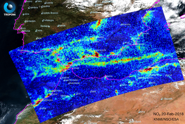
Shipping lane: The Tropomi instrument detects a suite of gases including nitrogen dioxide
Nitrogen dioxide is a product of the combustion of fuels, in this instance from the burning of marine diesel.
But it is also possible to see in the picture the emissions hanging over major urban areas on land that come from cars, trucks and a number of industrial activities.
NO₂ will be a major contributor to the poorer air quality people living in those areas experience.
First images of climate satellite Tropomi: a bird's-eye view of the world's hotspots of nitrogen dioxide (NO2) emissions.
The images were all taken in one day.
Sentinel-5P is the next big step because of its greater sensitivity and sharper view of the atmosphere.
"Shipping lanes are something we've seen on previous missions but only after we've averaged a lot of data; so, over a month or a year. But with Tropomi we see these shipping lanes with a single image," Dr Veefkind told BBC News.
"The resolution we got from our previous instruments was about 20km by 20km. Now, we've gone down to 7km by 3.5km, and we are thinking of going to even smaller pixels."
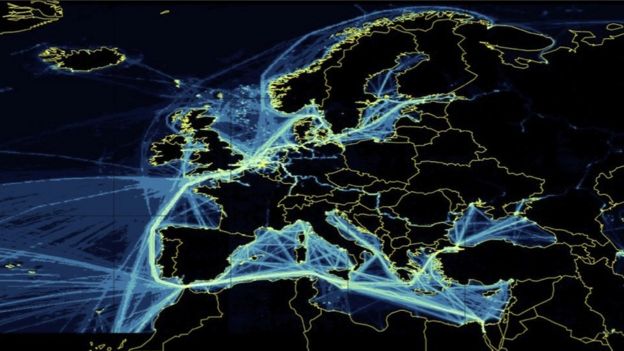
"Bottom up" accounting: Estimate of CO2 emissions from ships in 2016
Eyes in the sky
Far beyond the horizon, steaming through the remote High Seas, the great fleets of global shipping have for years been too distant to be observed.
Only in port can anyone catch sight of the plumes of dark smoke rising from the vessels' engines.
But added together, the greenhouse gases from the world's 50,000 ships make this industry the world's sixth largest emitter, and most of it is unseen.
This has long fuelled suspicions among environmental campaigners.
Exempt from the Kyoto Protocol and then the Paris Agreement, shipping acquired a reputation as a sector that dodged its responsibilities on climate change.
That's why the landmark deal earlier this month for a cut in emissions of 50% by 2050 received so much attention.
But it also raised a host of questions about policing: who would keep watch, and how?
Europe's Sentinel programme is part of the answer.
Suddenly, at just the right time, the world's shipping lanes are in full view.
S5P's availability is timely.
The shipping sector has just signalled its intention to make big reductions in its emissions over the next 30 years, in particular of the greenhouse gas carbon dioxide.

Early comparison between CAMS current operational products (left) and first Sentinel-5P data products (right).
The snapshots presented here show the carbon monoxide distribution (average mixing ratio, in ppb), an important atmospheric pollutant and tracer of combustion sources, on two consecutive days. (Credit: CAMS data from ECMWF, Sentinel-5P data courtesy of SRON/NSO/ESA [Borsdorff, Landgraff et al., Geophys. Res. Let., 2018])
see Copernicus
At the moment, those emissions are calculated in a "bottom-up" fashion.
By knowing the size of the global fleet, where it moves, the ships' specifications and how much fuel they are likely consuming - it is possible to estimate how much CO₂, or indeed NO₂, is being pumped into the atmosphere from exhausts.
But this all involves quite a few assumptions, and so the models need to be audited by some top-down analysis as well - which is where satellites come in.
S5P-Tropomi does not see CO₂, although its NO₂ observations can act as a tracer in the sense that wherever nitrogen dioxide turns up on shipping lanes, there will be CO₂ present, too.
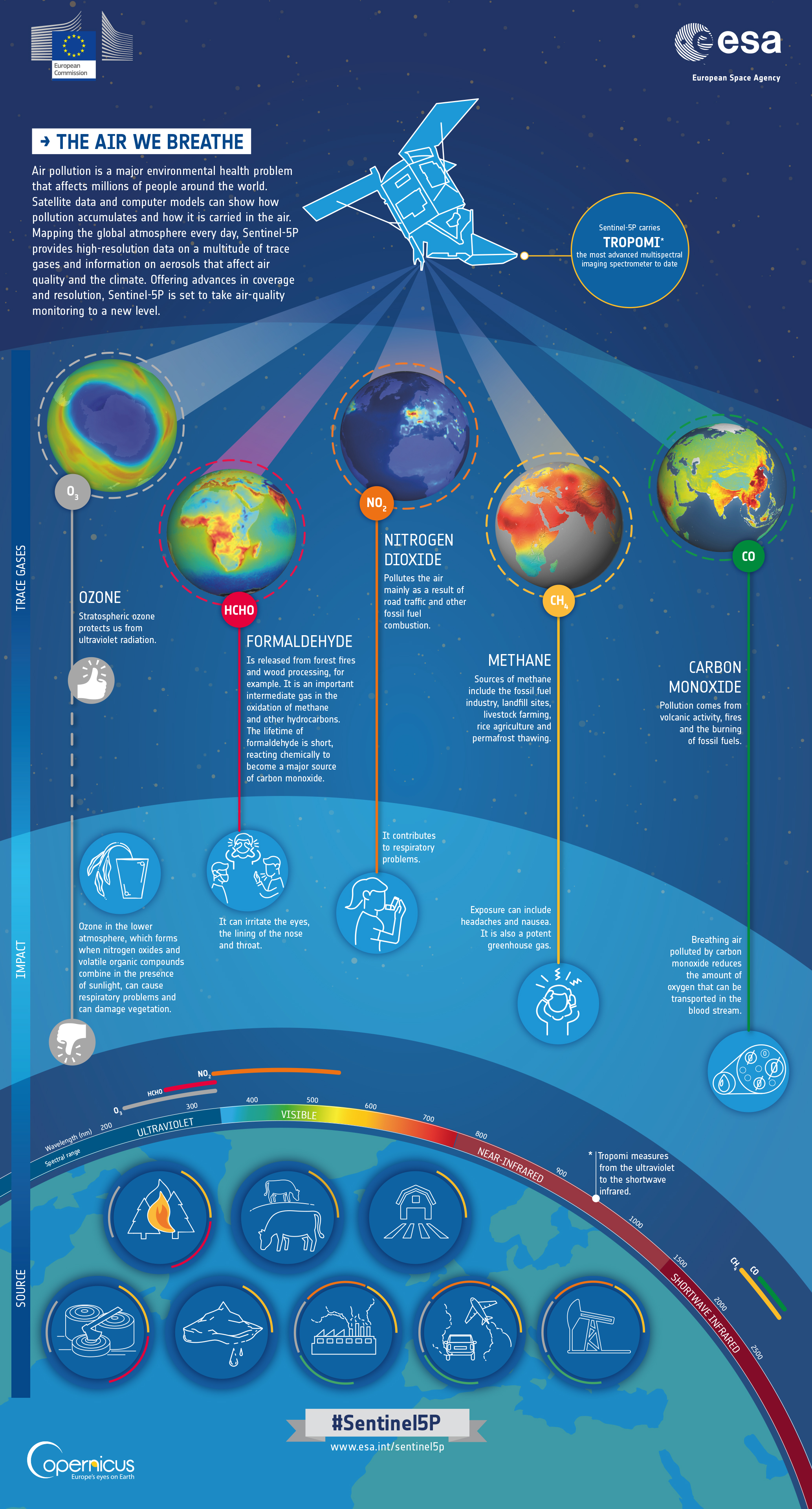
Sentinel5P infographic (ESA)
But the best solution would be a dedicated carbon-monitoring satellite.
This is why the EU has asked its technical agent on space matters, the European Space Agency, to design a Sentinel specific to the task.
Dubbed Sentinel 7 by many people, because that is the next available number in the series, this future mission should fly in the 2020s.
The aim is to be able track CO₂ down through the atmosphere on a scale of around 3km by 3km, but over a wide area.
That would make Sentinel 7 a forceful partner for Sentinel 5.
Links :
No comments:
Post a Comment