 A 3-D image of the Diamantina
Escarpment on the seafloor of the Indian Ocean.The search for Malaysia
Airlines Flight 370 has helped create maps revealing the ocean floor’s
topological complexity.
A 3-D image of the Diamantina
Escarpment on the seafloor of the Indian Ocean.The search for Malaysia
Airlines Flight 370 has helped create maps revealing the ocean floor’s
topological complexity.
Credit
Kim Picard and Jonah Sullivan
From NYTimes by Nicholas St Fleur
On March 8, 2014, Malaysia Airlines Flight 370
vanished with 239 passengers and crew aboard as it crossed the Indian
Ocean, triggering a large-scale search for its remains that lasted nearly three years.

South West of Australia with the GeoGarage (AHS chart)
As a byproduct of the tragedy, scientists have gained access to more
than 100,000 square miles of seafloor mapped at a level of detail that
provides a rare look at the ocean’s geological processes.
“It’s an incredible trove of data,” said Millard F. Coffin,
a marine geophysicist from the Institute for Marine and Antarctic
Studies at the University of Tasmania in Australia.
“I’ve been working
in this part of the Indian Ocean for 30-plus years and over many voyages
in the eastern Indian Ocean I’ve never seen this level of resolution.”
Dr. Coffin worked with a group of about 10 scientists from Geoscience Australia,
the national geosciences agency in Australia, to analyze data from the
search.
They were given access to high-resolution sonar information
collected on ships, and data obtained by remotely operated vehicles and
autonomous underwater drones.
The information was provided by the Australian Transport Safety Bureau, which led the search.
“When
we look at these data, we’re constantly keeping in mind that we
wouldn’t have this data if it weren’t for a terrible tragedy,” Dr.
Coffin said.
He and his colleagues published a summary of their findings
on Wednesday in the journal EOS.
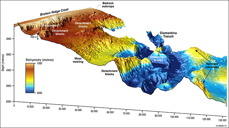
A 3-D model of the Broken Ridge along the Diamantina Escarpment.
Credit
Geoscience Australia
Previous
satellite data provided scientists with information about the Indian
Ocean at a resolution of about five square kilometers, or about two
square miles.
With the instruments from the search ships, they have
collected information at a resolution of meters, and in some locations
they have used remote operating vehicles and underwater autonomous
vehicles to gain detail on the scale of centimeters.
The
search has helped create three-dimensional maps of the ocean floor that
reveal its topological complexity and will allow researchers to further
investigate unique features like the oceanic plateau called Broken Ridge, and its southern-flank Diamantina Escarpment.
The Flight 370 search also provided information about tectonic and volcanic activity, Dr. Coffin said.
The
team plans to release more detailed looks into its findings later in
the year, and the full data set from the search will be made available
in the middle of the year.
Walter H.F. Smith,
a geophysicist with the National Oceanic and Atmospheric
Administration, said the hunt for the lost jetliner highlighted how
little we know about the oceans.
In a paper that was also published
Wednesday in the journal EOS, he and his colleagues explained how common unmapped areas of ocean are.

Satellite-derived gravity field (gray) [Sandwell et al., 2014]
and multibeam echo sounder (color) data were used to produce these maps
of the MH370 search area in the southeast Indian Ocean.
The relief
models are shown in Sun-illuminated (shaded relief) mode.
The inset map
shows the MH370 search area that was mapped with multibeam echo sounding
(shown in red).
This map highlights the Southeast Indian Ridge (SEIR)
and the Kerguelen Plateau, and it includes estimated spreading rates of
the SEIR [Argus et al., 2011], lines delineating regions of approximately equal age (isochrons [Muller et al., 2008]), and interpretations of SEIR segments (I–VII [Small et al.,
1999]).
Other abbreviations are AAD, Australian-Antarctic Discordance;
CIR, Central Indian Ridge; RTJ, Rodriguez Triple Junction; SWIR,
Southwest Indian Ridge; WA, Western Australia.
The larger map shows
details of the ocean depth mapping effort using multibeam echo sounder
bathymetry data. Locations of Deep Sea Drilling Project (Leg 26) and
Ocean Drilling Program (Legs 121 and 183) Sites 255, 752 to 755, 1141,
and 1142 are also indicated, as are the locations of Figures 2, 3, and
4.
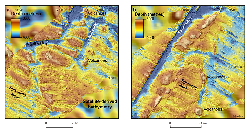
Multibeam echo sounder bathymetry map of two regions of the ocean floor
around the Geelvinck Fracture Zone in the Australian-Antarctic Basin
south of Broken Ridge (see above for locations).
The fracture zone
offsets the SEIR by about 310 kilometers.
The
right-lateral transform fault motion (a person standing on one side of
the fault would see the opposite side displaced to the right) that
created this fracture zone was mostly horizontal.
Note the fracture zone
fault valleys, mid-ocean ridge spreading fabric, and isolated
volcanoes.
“There
are all kinds of things you can’t do if you don’t know the shape of the
ocean bottom, or don’t know it properly,” Dr. Smith said.
The
consequences of not knowing, he said, can hinder how experts predict
tsunamis, understand ocean currents, make climate forecasts, study
marine life and search for missing planes.
Previous studies
have suggested that only 8 percent of the world’s oceans have been
mapped, meaning that a ship measured an area’s depth and recorded it in a
scientific database.
Before Flight 370’s disappearance, only 5 percent
of the southeast Indian Ocean had been mapped, Dr. Smith said.
The differences in resolution between multibeam and satellite-derived
bathymetry data for the northern flank of Broken Ridge are apparent
here.
Numerous mass wasting features are evident, including slides and
debris flows (delineated by their head scarps) that crosscut and run out
as debris fans into the large semicircular depression
To
figure out how often people fly over unmapped parts of the world’s
oceans,
Dr. Smith and his colleagues compared data on mapped and
unmapped segments of the world’s ocean segments with a database of commercial airline routes.
They found that about 60 percent of all commercial flights that cross
over the ocean travel over waters with unmeasured depths.
The
longest contiguous route over unmapped ocean was from Kennedy
International Airport in New York to Chongqing Jiangbei International
Airport in China, a journey over more than 1,200 nautical miles of
unmapped ocean.
“I
wanted people to realize that it’s not just Malaysia Airlines straying
into the southeast Indian Ocean where it shouldn’t have been,” he said.
“Even when your aircraft is exactly where it’s supposed to be, it might
be over unknown ocean.”
Links :
- GeoGarage blog : The search for MH370 is over: what we learnt and where ..
Hydro : Increased Resolution Bathymetry in the Southeast Indian Ocean
ReplyDeleteAtlasObscura : Explore the Seafloor With Data Collected During the Search for MH370
ReplyDelete