Saturday, January 24, 2015

Sea bites - Battle against the sea


The line between bravery and fear for a bite out of the sea.
The wind roars.
The sea crashes against the cliff.
Two meters of rock, that is the strip of water and oxygen where the goose barnacle grows.
Two meters where the sea shows no mercy, and beats with millenary strength.
A line of waves and foam where Serxo and his comrades fight for a bite out of the sea.
A line between bravery and fear.
Between recklessness and common sense.
Two meters without margin of error.
That is where the barnacles live. Where Serxo lives.
'Sea bites' is the battle against the sea from some warriors that don't consider themselves heroes.

Friday, January 23, 2015

The oceans are warming so fast, they keep breaking scientists' charts

 2014 continues long-term global warming
 The year 2014 now ranks as the warmest on record since 1880,
according to an analysis by NASA scientists.
This video shows a time series of five-year global temperature averages, mapped from 1880 to 2014, as estimated by scientists at NASA’s Goddard Institute for Space Studies (GISS) in New York.
While scientists expect temperatures to fluctuate from year to year, the average temperature of the planet as a whole has warmed by about 1.4 degrees Fahrenheit (0.8 degrees Celsius) since 1880.
This trend is largely driven by increasing human emissions of carbon dioxide and other greenhouse gases into the atmosphere.
The GISS analysis incorporates temperature measurements from 6,300 weather stations around the world, ship- and buoy-based ocean temperature readings and data from Antarctic research stations.
These measurements are plugged into an algorithm that then estimates average global temperature.

From The Guardian by John Abraham

NOAA once again has to rescale its ocean heat chart to capture 2014 ocean warming

Wow, was this a bad year for those who deny the reality and the significance of human-induced climate change.
Of course, there were the recent flurry of reports that 2014 surface temperatures had hit their hottest values ever recorded.
The 2014 record was first called on this blog in December and the final results were reported as well, here.
All of this happened in a year that the denialists told us would not be very hot.

Analysis by NOAA shows that in 2014, the combined land and ocean surface temperature was 1.24°F (0.69°C) above the 20th century average, making the year the warmest since records began in 1880.
The ocean alone was record warm, while the land alone was fourth warmest.
Five months set new records for warmth: May, June, August, September, and December. October tied for record warmest.
The 20 warmest years in the historical record have all occurred in the past 20 years.
Except for 1998, the 10 warmest years on record have occurred since 2002.
This animation shows Earth’s surface temperature from 1880-2014 compared to the 20th-Century Average.
The maps and graph are based on the MLOST data from the NOAA National Climatic Data Center.

But those denialists are having a tough time now as they look around the planet for ANY evidence that climate change is not happening.
The problem is, they’ve been striking out.
And just recently, perhaps the most important bit of information came out about 2014 – how much the Earth actually warmed.
What we find is that the warming is so great, NOAA literally has to remake its graphs.

Let me explain this a bit.
We tend to focus on the global temperature average which is the average of air temperatures near the ground (or at the sea surface).
This past year, global air temperatures were record-breaking.
But that isn’t the same as global warming.
Global warming is properly viewed as the amount of heat contained within the Earth’s energy system. So, air temperatures may go up and down on any given year as energy moves to or from the air (primarily from the ocean).
What we really want to know is, did the Earth’s energy go up or down?

The trick to answering this question is to measure the change in energy of the oceans.
A thorough review of ocean heat measurement methods is found here; we paid the requisite fee to make the paper open access.
Anyone can download and read it.

So what do the new data show?
Well, it turns out that the energy stored within the ocean (which is 90% or more of the total “global warming” heat), increased significantly.
A plot from NOAA is shown above.
You can see that the last data point (the red curve), is, literally off the chart.

 Ocean heat content data to a depth of 2,000 meters, from NOAA.

The folks at NOAA do a great job updating this graph every three months or so.
We can now say that the 2014 Earth had more heat (thermal energy) than any year ever recorded by humans.
We can also say that the folks at NOAA will likely have to rescale their graph to capture the new numbers
The NOAA site is updated by Dr. Tim Boyer and can be found here.

If people want to read a review of ocean heating that is written for a general audience, I suggest our recent peer-reviewed paper which can be found here.

So when we look back on 2014 and the records that fell, it gives us some pause about the so-called pause (hat-tip to Dr. Greg Laden for that phrase).
Some people tried to tell us global warming had “paused”, that it ended in 1998, or that the past 15 years or so had not seen a change in the energy of the Earth.
This ocean warming data is the clearest nail in that coffin.
There never was a pause to global warming, there never was a halt, and the folks that tried to tell you there was were, well, I’ll let you decide.
For me, the facts speak for themselves.

Links :
  • NASA : NASA, NOAA find 2014 warmest year in modern record

Thursday, January 22, 2015

Catapult and Pew Charitable Trusts launch pioneering technology to help end illegal fishing

Project Eyes on the Seas: Pioneering Technology to Help End Illegal Fishing The Pew Charitable Trusts launched groundbreaking technology that will help authorities monitor,detect, and respond to illicit fishing activity across the world’s oceans.
Project Eyes on the Seas, as the system is known, furthers a long-term effort by Pew to dramatically reduce illegal or "pirate" fishing.

From Satellite Applications Catapult

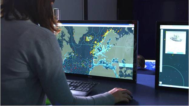
The Satellite Applications Catapult, an independent technology and innovation company, and The Pew Charitable Trusts, today launched their ground-breaking near real-time technology that will help authorities monitor, detect and respond to illegal fishing activity across the world’s oceans.

The live satellite monitoring system, Project Eyes on the Seas, has been developed by the Catapult for Pew and will initially be launched in the waters of Chile, Palau, and the UK Overseas Territories.
It is the latest significant stage in a long-term effort by Pew to dramatically reduce illegal or “pirate” fishing around the world, which is valued at $23.5bn annually.

Live satellite monitoring system
The Virtual Watch Room will initially cover the waters surrounding Easter Island, a Chilean special territory; the Pacific island nation of Palau; and Pitcairn Island, a British overseas territory in the South Pacific. 

Using multiple sources of live satellite tracking data, the system analyses the data and links it to information about a ship’s ownership, history and country of registration, providing a dossier of up-to-the-minute data that can alert officials to suspicious vessel movements.

 S-AIS data from ExactEarth, partner of Catapult

Stuart Martin, CEO of the Satellite Applications Catapult, said: “Satellite data is playing a key role in helping to put an end to illegal fishing. Through the tenacity of The Pew Charitable Trusts and the innovation and technological advancements developed by the Catapult and industry players, protecting our seas, the ecosystem and the livelihood of many villages can now become a reality, rather than an idealistic goal. The Catapult is delighted to be able to play a part in this.”

Project Eyes on the Seas will launch initially with a ‘Virtual Watch Room’ monitoring the waters surrounding Easter Island, a Chilean special territory; the Pacific island nation of Palau.
Over the next three years, the plan is to grow the system’s capability and scope as more countries, regional fisheries management organisations, and seafood retail groups commit to using it to ensure that only legally caught seafood is taken from the ocean and reaches consumers’ plates.

The Satellite Applications Catapult has partnered with the non-governmental organisation Pew Charitable Trusts and satellite data services company exactEarth Europe to capture and analyse satellite shipping data, and merge it with data from coastguards and local fishermen around the world to pinpoint the location of suspect vessels.
The result will be a powerful, nimble programme that will allow illegal fishers to be detected, tracked and prosecuted.

Joshua Reichert, Executive Vice President of The Pew Charitable Trusts, explained: “Project Eyes on the Seas is designed to transform the current very expensive and patchy system of information gathering and enforcement into a global system for identifying and tracking illegal fishing vessels that is far more cost effective. This system will enable authorities to share information on those vessels operating outside of the law, build a comprehensive case against them, track them into port or within reach of enforcement vessels, and take action against them.”

 Virtual Watch Room

The Virtual Watch Room is intended to pay immediate dividends in remote ocean areas where Governments are considering establishing marine reserves to safeguard some of the planet’s last remaining near-pristine marine habitats.

 Using the Virtual Watch Room to identify suspicious activities 
courtesy of Pew Trusts
  • The application is designed to hold and cross-reference vast amounts of data so that when fused, the results can help identify suspicious vessel activity in an efficient and cost-effective way.
  • The information includes multiple sources of satellite data, vessel and other specialist databases, international fishing and marine reserve boundaries, and oceanic data such as depth and temperature.
  • The system can activate the most appropriate surveillance method to see vessels that are not transmitting their positions.
  • Automatic alerts are triggered when the computer, using specially designed algorithms, detects:
  • Patterns of vessel movements or speeds typical of fishing.
  • When a vessel has stopped signaling its position.
  • Two vessels in close proximity, a possible sign of transshipment of fish or other goods.
  • When a vessel crosses a virtual geofence to enter a marine reserve or other area of restricted use.
  • Alerts are investigated by trained analysts.
  • Analysts notify relevant government enforcement of highly suspicious activity and transfer a data package of supporting evidence.
  • Governments proceed with enforcement action or other appropriate response.
As the system develops into the next phase, new data sources will be integrated to add emerging technologies and respond to evolving needs.
Among the potential sources are additional satellite imagery, various types of optical imagery, imagery from unmanned aerial vehicles, crowd-sourced photographs and sightings, electronic signals such as radar on ships, and possibly radio broadcasts.

Over the next three years, the plan is for Project Eyes on the Seas to grow in capability and scope as more countries, regional fisheries management organizations, and seafood retail groups commit to using it to guarantee that only legally caught seafood is taken from the ocean and reaches consumers’ plates.

Links :

Wednesday, January 21, 2015

U.S. cities lag in race against rising seas

Sea level rise planning tool - New York City (ESRI)

From Scientific American by Brittany Patterson

In December, residents in Marin, a county in the northern part of the San Francisco Bay Area nestled across from the Golden Gate Bridge, woke up to find that some of their roadways, docks and parking lots were underwater.
Unlike in past years, when the king tides—unusually high tides that occur when the sun and moon are closer to the Earth—were accompanied by stormy weather, residents this year were faced with just some minor flooding.

But more and more, parts of California are seeing an increase in such flooding, said Gary Griggs, director of the Institute of Marine Sciences at the University of California, Santa Cruz.
Griggs is among the scientists who sat on a legislative committee to examine how rising sea levels will affect the California economy.
He said in the last four years California has shifted from thinking about rising sea levels as a "black box" toward putting money where the science is.
"A number of communities realize they're losing land," he said, adding that in some ways "nuisance" flooding might be to thank for continuing to keep the rising sea levels conversation open.
"Those events are raising the visibility and making it more immediate," he said. "In some ways, it's a good thing."
In just a few decades, most U.S. coastal regions are likely to experience at least 30 days of nuisance flooding every year.
Washington, D.C.; Annapolis, Md.; and Wilmington, N.C., are already in trouble.
By 2020, seven more cities, including Baltimore and Atlantic City, N.J., can add themselves to the list.
And within the next 35 years, most cities along all coasts will be dealing with routine flooding.

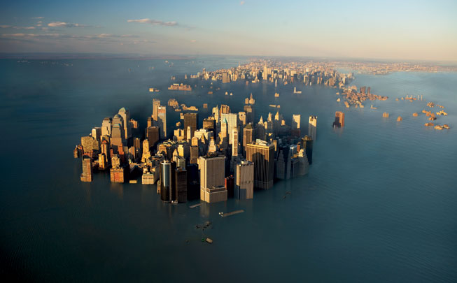
 Flooded NY

An ominous message from the 'future'

The term "nuisance flooding," which is not as glib as it sounds, basically means municipalities can expect to see more water in the streets and low-lying areas and can expect not only inconvenience but modest damage thanks to rising sea levels spurred by climate change.
This is one message from a study released in December in the journal Earth's Future by two oceanographers at the National Oceanic and Atmospheric Administration who took tidal data from cities with a continuous 50-year measurement and added local sea-level rise projections to show what the future would look like.

The results: Sea-level rise has not only accelerated, from 1.7 millimeters a year in the last century to 3.2 mm a year in the last two decades, but flooding events that were once extreme are expected to become much more likely.

William Sweet, one of the authors, said the idea behind developing the "tipping point" measurement was to bring some immediacy to the impacts of sea-level rise.
"Much of the discussion around sea-level rise is around main sea-level rise, 2 feet by 2100, for example," he said.
"That problem is understood to be in the future, but we wanted to use projections to show when the impacts of sea-level rise become frequent enough that they will actually spur action."
Some cities, such as New York, are bolstering their shorelines in response to extreme events, such as Superstorm Sandy.
But with more than half the U.S. population living within 50 miles of the coast, many areas are just at the beginning stages of preparing to deal with rising sea levels and the increased flooding they bring.

"Climate change is particularly tricky," said Alexander Aylett, a professor at the National Institute of Scientific Research in Montreal and author of a Massachusetts Institute of Technology report, "Urban Climate Change Governance Survey," that examined to what extent cities around the world are trying to tackle climate change.
"Governments are used to dealing with problems that are somebody else's business," he said.
"The people who build your roads don't regulate what happens on top of them or how we build next to them, but climate change is everywhere, all the time, all at once."

 Annapolis, Maryland, pictured here in 2012, is one of three major East Coast urban areas already being faced with nuisance flooding in excess of 30 days per year.
(Credit: Amy McGovern)

Washington, D.C., begins to stir

Sweet and co-author and fellow NOAA oceanographer Joseph Park's data showed the nation's capital was one of the locations already experiencing 30 or more days of flooding a year.
More than that, in just 15 years, Washington is expected to see flooding more than 6 feet above the local high tide line—a level topped just once in the last 70 years.
To put that in perspective, $4.6 billion in property value, and 1,400 people in 400 homes, sit on this area, according to a report released in September by the nonprofit Climate Central, which used NOAA and other data sets for these projections.

D.C. has multiple plans at various stages, but the process to address climate change began in earnest in 2008 when localities adopted the "Washington Capitol Regional Climate Change Report," which set short-, medium- and long-term goals, such as reducing greenhouse gas emissions and making buildings more energy efficient.
For example, a short-term goal of reducing regional greenhouse gas emissions by 10 percent under business-as-usual terms by 2012 is still being evaluated, but the first few areas measured seem to have met their targets, said Stephen Walz, director of the Department of Environmental Programs for the Metropolitan Washington Council of Governments.

Implementing adaptation measures, especially to address sea-level rise, is ongoing.
Reports of future flooding at the National Mall have prompted the relocation of certain collections to higher ground, and parts of the Metro system have been rebuilt with higher curbs to circumvent flooding, Walz said.
As for nuisance flooding, Walz said more water on the streets has prompted an acknowledgement that changing conditions need to be accounted for when plans for a region are being made.
"When you size a culvert now, you're going to have to size it bigger to carry more water," he said, as an example. "So engineers and architects are going to have to make changes to that."

 The calculator tool generates curves of relative sea level change (RSLC) projected through the year 2100 for coastal U.S. locations (above: Atlantic City, NJ)

A few cities awaken in Md.

For Kate Skaggs, nuisance flooding has been anything but, at least when it comes to pushing for more action on sea-level rise in Maryland.
"It's helped us to communicate sea-level rise in a much more concrete way, instead of just an abstract idea of sea-level rise," she said.
Skaggs works with the CoastSmart Communities grant program, a NOAA-funded initiative that provides grants to local governments in Maryland's coastal zone to better prepare for rising sea levels and other coastal hazards.
Seventy percent of Maryland's residents live in the 16 counties within the coastal zone.
Climate change has been on the agenda in Maryland for more than 15 years, prompted by concerns over land erosion.

In 1998, Zoe Johnson, program manager for climate change policy at the Maryland Department of Natural Resources, drafted a sea-level rise strategy.
It was adopted two years later, and the state has been working to implement it since.
Both Skaggs and Johnson agree that, over the years, collaboration between agencies has increased and state-level policies have solidified Maryland's approach to climate change.
"We've transitioned from building plans to implementing actual projects," Skaggs said.
Flooding has catalyzed some action in certain communities such as Annapolis, Johnson said.
"We had funded two years of looking into the vulnerability of sea-level rise there, but it wasn't until there was more and more chronic flooding and number of days that they had to close streets during a boat show in downtown where then the city had to deal with the question of 'How do we deal with this?'" she said.
Many places have implemented government policies such as requiring increased amounts of freeboard, or the distance between where water would fall and where the building begins, but Johnson notes bigger projects are going to call for a much larger capital investment.

 Picture of Seaside Heights, NJ after Hurricane Sandy

Thinking about mitigation, maybe

One field of thought is to mitigate the ongoing effects of changing climate by reducing greenhouse gas emissions and building more energy-efficient buildings.
The second way we can deal with the effects of climate change is to adapt.
Build higher walls, move to higher ground.
Klaus Jacob, a Columbia University research scientist who has been a consultant for the New York Metropolitan Transit Authority, argues that a lack of political willpower stems from not only the slow rise of sea levels, but the sheer amount of money it will take to meet the challenge.
His estimate is well over a trillion dollars this century.
"If we don't do anything, it's multiple trillions of dollars," he added.

Part of the challenge is that the United States is far behind the rest of the world.
Globally, Aylett's survey of 350 cities found that 73 percent are considering climate change mitigation and adaptation, while 58 percent of American cities said the same.
Forty-one percent of American cities said they were only thinking about mitigation, almost double the global average.
Aylett said the reasons the United States lags are threefold.
First, his survey found that the majority of cities, although they are dealing with climate change, had not yet figured out how to make it a part of their economy.
Second, North American cities report they are the most understaffed when it comes to climate change planning, often reporting they have staffs of one person.
Third, the United States hasn't transitioned from using all the data that have been collected about the vulnerabilities facing cities into taking action.
With mitigation, a city tallies emissions, sets a level to decrease them by and gets to work. Aylett said it's only very recently that we've gotten to the same place for adaptation.
"We now have a lot of potential to do a lot," he said.
"Potential only goes so far."

 Severe coastal erosion, California.
Photograph: © SAF

A planning budget is born in Calif.

Rising sea levels first came to the attention of Democratic California Assemblyman Rich Gordon before he joined state government.
Gordon's constituents when he was a San Mateo county supervisor found themselves with the Pacific Ocean on one side and the San Francisco Bay on the other.
When he arrived four years ago to the Legislature, he realized his concern about rising sea levels wasn't on anyone else's radar.

Gordon put together a select committee on sea-level rise and the economy, which researched and held hearings on what local communities throughout California were doing.
"We found there were planning efforts going on across the state," he said. "Not everywhere and oftentimes not in a well-coordinated matter, but people were thinking about it."
In September, Gov. Jerry Brown (D) signed into a law a bill that creates an online database where private and public entities in California can share sea-level rise plans.
And most surprisingly, what began as a request for a mere budget line to get sea-level rise on the books grew into a 2014-15 state budget allocation of $2.5 million.
Gordon said that money is just planning dollars at this point and not sufficient to do much in terms of adaptation or mitigation, but he hopes it will give the state a better idea of the financial burden preparing for sea-level rise will be.
As for the king tides and other more frequent flooding, Gordon said it's a wake-up call.
"There are certain places where we're going to need to invest sooner rather than later," he said.
"Our state agencies are communicating with each other, but we need to get local communities involved."

Links :
  • The Guardian : Almost 7,000 UK properties to be sacrificed to rising seas
  • DailyMail :  Thousands of UK homes to be lost as rising seas erode the coastline - and there is no compensation available for property owners
  • Washington Post : The rate of sea-level rise is ‘far worse than previously thought,’ study says

Tuesday, January 20, 2015

Mystery of the phantom islands solved: Lands that disappeared on ancient maps are revealed as mistakes, mirages and myths

The Zeno map of 1558 showing Frisland – a phantom island in the North Atlantic

From The DailyMail by Victoria Woollaston

  • Phantom islands are lands that appeared on maps before being removed
  • This includes islands which were spotted once but never seen again
  • While others were parts of existing lands and later renamed
  • In some cases it’s believed these phantom islands were mirages
  • The Emerald Island phantom also remained until as late as 1987
Today it’s easy to explore foreign lands and oceans simply by using Google Maps, but centuries ago, when these worlds were first discovered, people had no choice but to rely on the tales of explorers.
As these adventurers sailed uncharted seas and plotted what they saw, it was taken on face value that the lands they described existed.
Maps featuring these mysterious, and at times imaginary, places were copied and recreated for centuries - and in the case of the non-existent Emerald Island in the South Pacific, featured in atlases as late as 1987.

What is a phantom island ?

Centuries ago when the first explorers were traveling the world, people back home had to rely on the accuracy of their sightings.
As these explorers sailed the seas and plotted what they saw, it was taken on face value that these islands existed.
However, despite appearing on maps for decades, some of these spotted islands were never seen again, while others were renamed.
This phenomenon became known as the 'phantom island'.
Some were geographical errors, some were islands that were later reclassified or re-identified, while and some were mysterious land masses that people claimed to have visited but others couldn’t find.

 This map shows the location of phantom islands that appears on maps from the early 16th century, but later disappeared or were renamed


In the 1820s, British explorers on a ship called the Emerald reported sightings of an island south of the Macquarie Island, between New Zealand and Antarctica.

In the 1820s, British explorers on a ship called Emerald reported sightings of an island south of the Macquarie Island, between New Zealand and Antarctica, pictured bottom left.
However expeditions in 1840 and 1909 found no trace of it.
Despite this, the Emerald Island appeared on maps until 1987
This map shows where reports claimed the mysterious Emerald Island was located.
It is thought that the sightings were Fata Morganas, or mirages, similar to those seen in the desert, but are spotted in polar regions

Captain William Elliot and his crew wrote that the landmass, later called Emerald Island after the ship he was sailing on, was small and mountainous.
However, explorers from the U.S. who tried to locate the mysterious isle in 1840 found no trace of it.
The island was later spotted by a captain visiting Port Chalmers in New Zealand some 50 years after this expedition, yet a follow-up search by Captain John King Davis in 1909, on board the ship Nimrod, again found nothing.
 1912 German map showing Emerald Island south of Macquarie Island

Despite this, the Emerald Island featured on maps and in atlases until at least 1987, although it was gradually removed from many during that time.
In trying to explain these mysterious sightings, historians thought that Elliot and his crew may have seen what is called a Fata Morgana, or a mirage, similar to those seen in the desert but are spotted in polar regions.


Similarly, the Isle of Demons, was a mysterious mass of land off the coast of Newfoundland that first appeared on maps during the 16th century, before disappearing by the mid-17th century.

Legend has it that a woman called Marguerite de La Rocque was sailing to New France in Canada, now known as Quebec, and became pregnant to a sailor in 1542.
She was abandoned on the so-called Isle of Demons as punishment, to live with the devils and wild beasts that inhabited the area.
Two years later she was rescued by fishermen and taken to France, where the story became popular folklore and was even mentioned in poems by the late 19th century poet George Martin.
It is thought the island that de La Rocque was marooned on was part of Quirpon Island in the Labrador Sea, off the coast of Canada.

The Isle of Demons, was a mysterious mass of land off the coast of Newfoundland that first appeared on maps during the 16th century, pictured here in 1543, before disappearing by the mid 17th century
The story of the Isle of Demons became popular folklore and was mentioned in poems by the late 19th century poet George Martin.
It is thought the island was part of Quirpon Island in the Labrador Sea, pictured, off the coast of Canada

The Isle of Demons first appeared in 1508 and was often confused with the island of Satanazes, which means devils in Portuguese, located in the Atlantic Ocean.
According to portolan charts, or navigational maps, from 1424, Satanazes was shown to the west of Portugal, and north of another phantom island called Antillia.
It was shown with the inscription ‘Ista ixolla dixemo satanazes’ which means ‘This is the island called of the devils’.
This island was never formerly identified, but along with Antillia, many historians believe the two islands to be the coasts of North and South America.
More specifically, Satanazes may have been Florida, while Antillia may be what early explorers called modern-day Cuba, although this has never been verified.


The legend of Antillia is believed to have originated during the Muslim conquest of Hispania in 714.
Christian bishops, looking to flee the peninsula, were said to have sailed until they landed on an island known then as Antilha.

According to reports, the Isle of Demons was often confused with the island of Satanazes.
Charts from 1424 show Satanazes to the west of Portugal, right, near another phantom island called Antillia, left.
Many historians believe the two islands to be the coasts of North and South America

It first appeared on maps and nautical charts from 1424 until the 15th century, although after 1492 when the region was more accurately charted, the island was removed from many maps.

Frisland 

Frisland was a phantom island that appeared on maps of the North Atlantic for almost 100 years between the mid-1500s to 1660s.
It appeared on a 1558 map as an island to the south of Iceland and continued to feature on the maps of famous cartographers Maggiolo, Mercator and Jodocus Hodius through the 16th century.
It was left off some of the early maps of Europe in the 17th century, but reappeared in 1630 off the east coast of Labrador.
However, by 1652, it no longer featured on the world map and was never recorded again.
Historians have claimed Frisland was part of Iceland, and later Greenland, or may have even been the Faroe Islands.
However, explorers in the mid-18th century who were responsible for mapping the waters where Frisland was thought to be, claimed the island was in fact Fair Isle, an island found between Shetland and Orkney Islands off the coast of Scotland.

Frisland was a phantom island that appeared on maps of the North Atlantic for between the mid-1500s and 1660s.
It appeared on a 1558 map, pictured, as an island to the south of Iceland and continued to feature on the maps of famous cartographers Maggiolo, Mercator and Jodocus Hodius through the 16th century
Historians have claimed Frisland was part of Iceland, and later Greenland, or may have even been the Faroe Islands.


In a similar region to Frisland, explorers reported sightings of an island that later became known as Thule.
The island was first referred to by Greek geographer Strabo.
In his reports of the ancient world called the Geographica, which Strabo was said to have begun as early as 20 BC, he recalls an account fellow Greek geographer Pytheas made of Thule in the 4th century BC.

Phantom islands are islands that appeared on maps before disappearing.
Among these is Thule, pictured here on the 1539 Carta Marina as Tile.
The island was first referred to by Greek geographer Strabo in reports taken from the 4th century BC. It was later identified as Greenland

Pytheas’ eye-witness account described the inhabitants of Thule as having ‘fertile land’ in which they grew fruit, crops, grain and honey.
Yet, the area lacked sunshine and floors were often ruined by rain.
They were also believed to paint themselves blue and ride on chariots, according to Roman poems.
Thule was always shown on maps, based on Strabo’s accounts, in the far north of the globe, yet the exact location varied from Norway to Orkney, Shetland and Scandinavia.
During the Renaissance period, the island was also identified as Iceland and Greenland.
More recently a municipality in northern Greenland once called Thule was renamed Avannaa. 

Links :

Monday, January 19, 2015

Asian piracy soars amid global decline

The Maritime Threat Picture globally monitors maritime incidents, casualties and threats to shipping; enabling companies to respond quickly to current incidents that may impact immediately 
- courtesy of GreyPage (click for dynamic viewing) -

  • Piracy, armed attacks on ships in Asia at highest since 2006
  • Armed guards not a solution to attacks -security expert
  • ReCAAP proposing extension of navy, coast guard patrols

From Reuters by Keith Wallis
Asia accounted for three-quarters of global maritime piracy last year after a surge in tanker hijackings helped to fuel a 22 percent jump in armed robbery and pirate attacks on ships in the region.

Total incidents per region in 2014, IMB Piracy Report Centre
see 2015 incidents

There were 183 actual and attempted piracy and robbery of ships in Asian waters last year, against 150 in 2013, a intergovernmental anti-piracy group told shipping industry and law enforcement personnel on Wednesday.
This put Asia's share of the total at 75 percent, after the International Maritime Bureau (IMB) released its global report for 2014 showing there were 245 actual and attempted acts of piracy worldwide last year.

In 2013, piracy in Asia accounted for less than 60 percent of the total.
However, attacks in Asia are mainly low level theft compared with kidnappings and more violent hijackings off West Africa and Somalia.


The number of attacks in Asia last year is the highest since 2006, when the Regional Cooperation Agreement on Combating Piracy and Armed Robbery against Ships in Asia (ReCAAP), a co-ordinating body with 20 government members, started compiling incident reports.

The rise in Asian piracy last year was due to the surge in tanker hijackings and better reporting by ship owners, ReCAAP deputy director Nicholas Teo told Reuters.
"There is no hiding the fact the 22 percent increase is significant and worrying," said Tim Wilkins, Asia regional manager for international tanker owners group, Intertanko.

Malacca Straight passage

While 114 attacks reported by ReCAAP were thefts from ships, mainly at ports and anchorages, the danger to crews should not be ignored, he said.
"The threat of violence is still reasonably significant," Wilkins told Reuters.
An engineer died after being shot by pirates who seized a tanker near Singapore in December, one of 15 tanker hijacking in Asia last year.
In addition, 12 tankers in Asian waters had their gasoil cargoes siphoned and stolen last year.


Putting armed guards onboard ships passing through the Malacca Strait and nearby waters - where many of the attacks occur - was not a solution and could increase the danger to sailors, a maritime security expert said.

"Using armed guards against hijackings, cargo thefts and shipboard robbery incidents around Singapore could result in an escalation in the level of violence used by the perpetrators," said Mark Thomas, Asia Pacific business development manager at maritime security consultancy Dryad Maritime in Singapore.
ReCAAP is proposing an extension of naval and coast guard patrols from the Malacca Strait into the South China Sea to help combat tanker hijackings and piracy incidents, Teo said.

Links :