Offshore, the seas glow with the light of hundreds of fishing boats lining up along invisible borders. (NASA Earth Observatory and NOAA National Geophysical Data Center)
From Scientific American by Steven D. Miller
A new Earth-viewing satellite sensor that can observe both natural and artificial sources of visible light at night is providing a treasure trove of high-quality information for scientists, meteorologists, firefighters and city planners.
The Day Night Band (DNB) sensor is so sensitive it can measure the glow of a single streetlamp from its vantage point 800 kilometers above.
With moonlight, the DNB can observe clouds, snow and sea ice in almost as much precision as conventional daytime observations.
Even on moonless nights the sensor can detect high-altitude pressure waves that modulate the atmosphere’s own faint glow.

Ship tracks in the East Pacific Ocean, and valley fog in British Columbia
source : CIMSS blog
I have presented several major applications of this new technology in “Night Watch” in the May 2015 Scientific American.
A few additional capabilities that emphasize human factors are highlighted here, which further demonstrate how the DNB is helping research and operational communities by land and sea.
(Details about the DNB—part of the Visible Infrared Imaging Radiometer Suite flying on the Suomi National Polar-Orbiting Partnership satellite—can be found at http://www.mdpi.com/2072-4292/5/12/6717).
Overall, the DNB is helping us realize that nighttime is nowhere near as dark as we might have thought—and that we no longer need to be “in the dark” when it comes to operating in the nocturnal environment.

Credit: NASA Earth Observatory (Squid boat satellite image).
Boats on Horizon photo is courtesy of Wikimedia Commons
But it can also provide poignant commentary on the current state of human divisions.
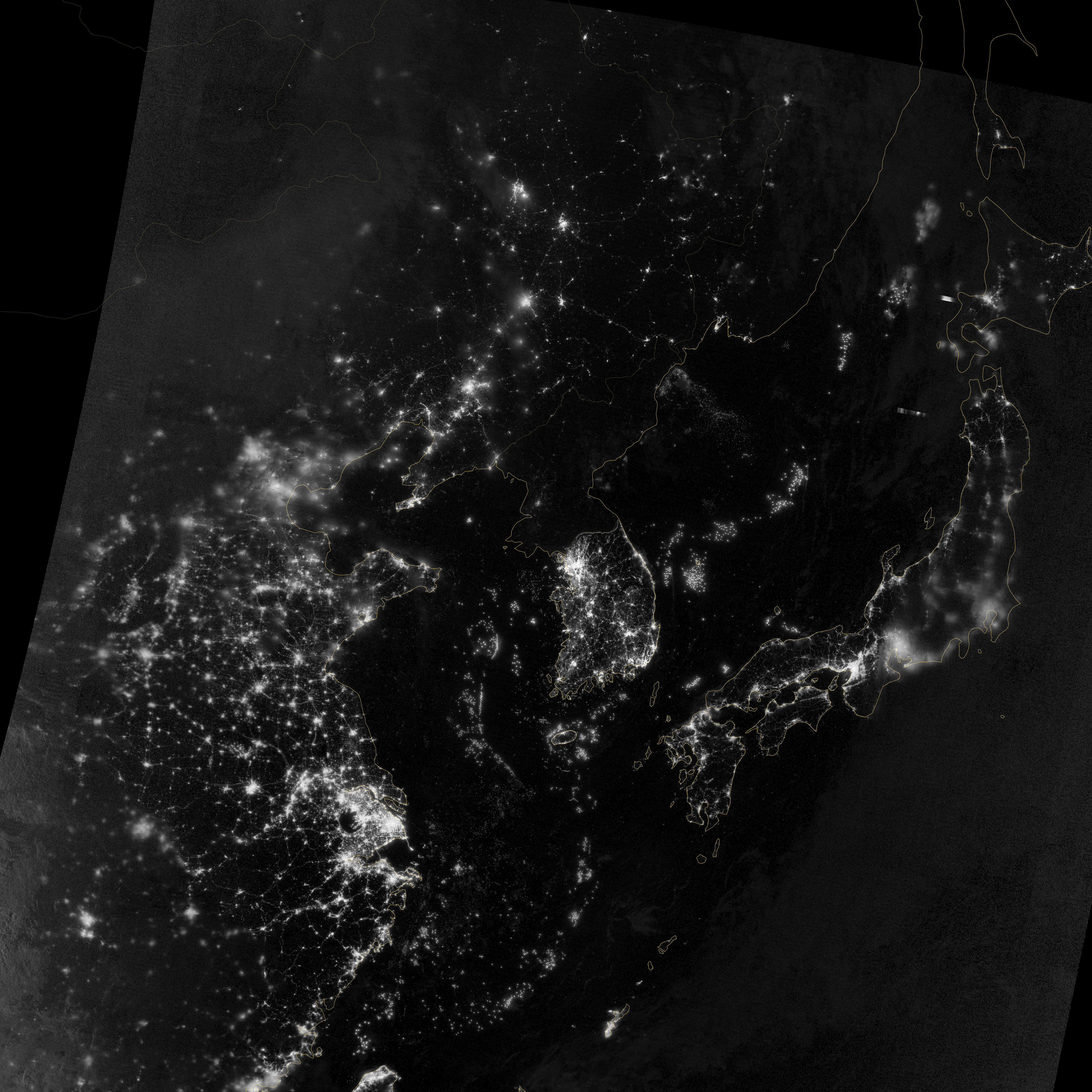
Sharp changes in regional lighting often delineate areas of poverty and economic prosperity, which is perhaps nowhere more prominently displayed than in the juxtaposition of mostly dark North Korea and well-lit South Korea (center of left-hand image).
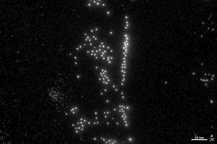
Squid boat fleets sometimes remind us of our divisions as well.
The DNB can detect individual boats, each appearing as a point of light against the dark ocean water. The vessels use high-powered lamps to attract squid to the surface, like moths to a flame (right).
The boats typically cluster in groups that follow schools of fishes from one night to the next. Sometimes the orientations of the clusters they form are tied in a benign way to natural features such as sea-surface boundaries that help form productive waters.
But in the Yellow Sea and East China Sea regions we can see that these boats often abut political boundaries that define zones of shared (provisional) and exclusive fishing rights for China, Korea and Japan.
According to local people, there are two possible reasons for these unusual alignments: One has to do with boats of another country attempting to get as close as possible to waters having more squid.
But another is purely political—the density of ships along these borders effectively blocks access to the “shared” waters, and could be a passive display of force related to territorial disputes among the surrounding nations.
It is a cold war of sorts but also a wet one, as coast guard ships use water cannon to ward off fishing vessels. Agencies in South Korea, Japan and Thailand as well as Peru, Argentina and Britain are now regularly requesting Day Night Band data to see if boats are fishing illegally.
Ship trails, not contrails

Credit: Images by Steven D. Miller
In less contested waters we see interesting effects of the maritime community at night as well.
We are all familiar with how the exhaust from jetliners alters the atmosphere, forming clouds called contrails—those thin, white streaks across the sky.
Recent research has shown that contrails can be significant enough to suppress sunlight hitting the ground below.
The exhaust of ships is associated with similar effects; the effluent modifies the marine boundary layer—clouds in the very low atmosphere.
The DNB readily detects these “ship trails” at night.
The left-hand image shows how effluents alter cloud microphysics off the coast of Baja, Calif.
The particles of smoke act as focal points for water condensation, leading to a great number of additional small cloud droplets, forming tracks that appear from above and resemble aircraft contrails.
The details of these tracks can be seen in the right-hand image; a trace of the ship’s path is formed. The bright point of light at the head of each track is a ship’s lights when the satellite flew over and captured the image.
The ability to observe these changes in clouds is more than an interesting commentary on ships passing in the night.
Like contrails, the ship trails have some important ramifications for climate.
Clouds reduce sunlight reaching the surface during the day and hold in surface heat at night.
Changes in the properties of clouds triggered by air pollution can alter Earth’s heat budget; even minor changes to clouds can yield a significant impact.
Links :
- NASA : Out of the Blue and Into the Black :New Views of the Earth at Night / Ship Tracks
- GeoGarage blog : Ship tracks off North America
- VIIRS boat detections (VIIRS can detect individual lighted fishing boats at sea)
No comments:
Post a Comment