Publisher : Geological Survey of Ireland (GSI)
Explore Ireland's territorial seabed and shipwrecks.
The high resolution underwater terrain data has been mapped to 100 meter resolution
From Independant.ie
For the first time in almost 60 years the exact measurements of the country's territorial waters, including part of the disputed Rockall Bank, are being taken from 50 specially selected points.

Rockall
Operation Baseline will help chart more accurate maritime maps and be used to cement claims to the continental shelf up to 350 miles from shore.
Over the last few weeks the Air Corps winched geographers on to some of the most inaccessible headlands and islands on our shores to mark co-ordinates first given to the United Nations in 1959.

source : GSI / Marine Institute
A Department of Foreign Affairs official said the new measurements will accurately record Ireland's shores and seas down to centimeters .
"The new coordinates will be used to update electronic maritime charts and the project will also allow the outer limits of the State's maritime zones to be determined with much greater accuracy," she said.
"More accurate mapping is important for a range of matters including exploration, licensing and law enforcement."
As part of the operation, an Ordnance Survey Ireland (OSi) team used GPS to pinpoint the 50 locations and permanently marked them with brass plates.
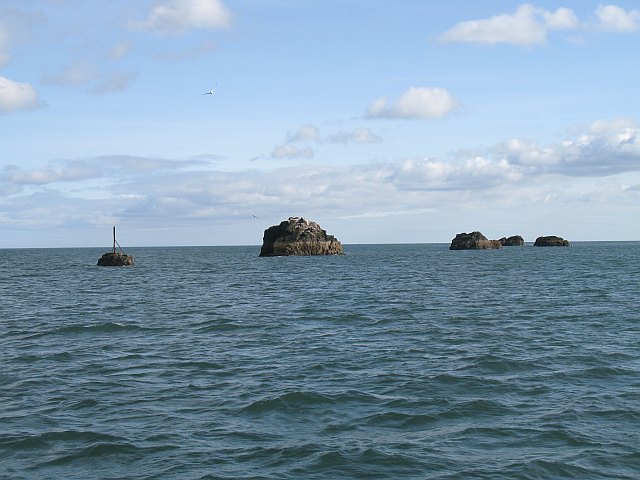
Scart Rock Skarv is the Norwegian word for cormorant.
Scarf and Scart are common place names and refer to rocks and skerries popular with cormorants. The rocks lie just off the entrance to Dunbar Harbour.
The most northerly is Scart Rocks off Malin Head, with the western extremities including an unnamed rock beside Black Rock lighthouse off Mayo and the Great Foze Rock off the Blasket Islands in Kerry.
Along the south coast Bream Point on Cape Clear in Cork and Carnsore Point in Wexford are on the limits.
Andy McGill, Operation Baseline co-ordinator with the OSi, said the job could not have been done without Air Corps pilots and winchmen and the Navy on standby.
"Basically it is redefining the territorial limits," he said.
"But it was extremely exhilarating. We had guys out there for 10-12 hours and it would take another six hours for them to calm down once they were back in - the adrenaline really gets going. You are working in an extremely hazardous environment.
"We didn't expect to get access to all the points but the guys in the Air Corps and Navy made it so easy."

Nautical map for Ireland with the Marine GeoGarage (UKHO)
Ireland has a 12 mile territorial sea, a 200 mile exclusive economic zone before any additional claims are made to the continental shelf including the Rockall Bank.
The Geological Survey of Ireland (GSI) says potential territorial waters stretch to 898,442km sq - an area bigger than the oil rich North Sea.
But claims to Rockall - the pudding shaped remnants of an extinct volcano in North Atlantic and the inspiration for a rebel song - are virtually pointless under international law.
Ireland has never attempted to seize the rock but it has made claims for some of the potentially oil rich sea bed around it up to 500 nautical miles from shore and known as Hatton-Rockall.
The claim has been agreed with the UK but is rejected by the Faroe Islands.
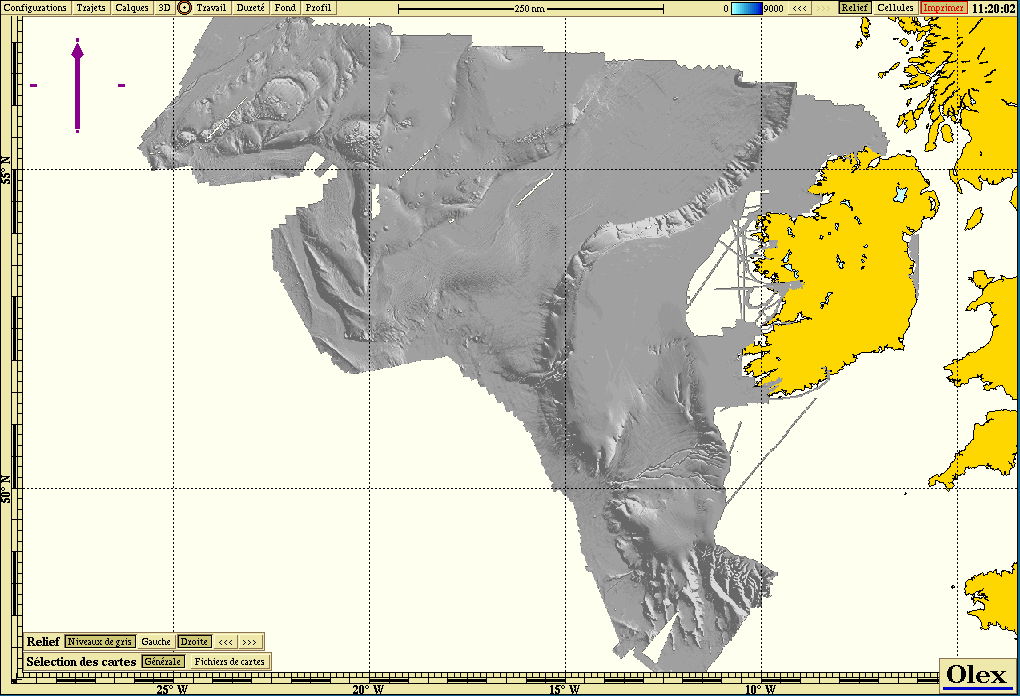
Bathymetric multibeam data from GSI in Olex software
Ireland has successfully claimed an extra 39,000 km sq of seabed off the west coast beside the Porcupine Bank and a second claim for a swathe of the Celtic Sea and Bay of Biscay is being negotiated with France, Spain and the UK.
Another 15 points will be marked as part of Operation Baseline in separate weather dependent missions over the next few weeks.
Links :
- IrishExaminer : Ireland gets back on rocky road to Rockall riches
- The Guardian : Who owns Rckall ? A history of legal and diplomatic wrangles
- GeoGarage blog : Rockall reveals what lies beneath
- Mida : the Marine Irish digital atlas
RTE news : 600 year-old map of Ireland to be auctionned
ReplyDelete