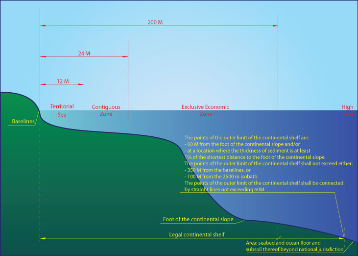
The term "continental shelf" is used by geologists generally to mean that part of the continental margin which is between the shoreline and the shelf break or, where there is no noticeable slope, between the shoreline and the point where the depth of the superjacent water is approximately between 100 and 200 metres.
However, this term is used in article 76 as a juridical term.
According to the Convention, the continental shelf of a coastal State comprises the submerged prolongation of the land territory of the coastal State - the seabed and subsoil of the submarine areas that extend beyond its territorial sea to the outer edge of the continental margin, or to a distance of 200 nautical miles where the outer edge of the continental margin does not extend up to that distance.
The continental margin consists of the seabed and subsoil of the shelf, the slope and the rise.
It does not include the deep ocean floor with its oceanic ridges or the subsoil thereof .
From AmericanPress
How much of the Gulf of Mexico is under United States control?
When and how did this happen?
The United States has a say in what happens in 700,000 or so square kilometers of the gulf — roughly the water north of a line drawn from the mouth of the Rio Grande to the Straits of Florida.
The U.S. government has full sovereignty over its territorial waters, which extend 12 nautical miles from a baseline measurement, which is defined in the United Nations Convention on the Law of the Sea as “the low-water line along the coast as marked on large-scale charts officially recognized by the coastal State.”
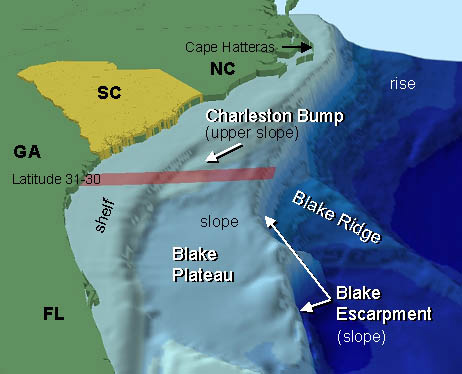
Southeastern United States continental shelf
The official charts, maintained by the National Oceanic and Atmospheric Administration, identify the baseline as the “mean lower low-water line,” or MLLW.
The baseline is set by the U.S. Baseline Committee, which is headed by the U.S. State Department.
(see determination of the National Baseline)

(see determination of the National Baseline)
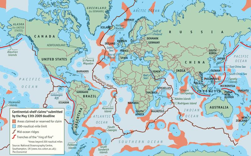
Continental shelf claims (2009)
The sovereignty in territorial seas extends to the airspace above the water and to the seabed beneath it.
In territorial waters, all nations’ vessels, including warships, have the right of “innocent passage” — i.e., presenting no threat to peace and security — but are subject to the sovereign nation’s laws.
Additionally, the U.N. convention — a treaty the U.S. adheres to but hasn’t ratified — recognizes coastal nations’ right to exercise some control over a “contiguous zone,” which abuts the territorial waters and extends an additional 12 nautical miles seaward.
In the contiguous zone, the U.S. may prevent and punish “infringement of its customs, fiscal, immigration or sanitary laws and regulations within its territory or territorial sea,” according to the treaty.

The territorial seas claim, which includes the waters around Guam, Puerto Rico and the U.S. Virgin Islands, was made by presidential proclamation in 1988.
The contiguous zone was established by presidential proclamation in 1999.


EEZ & ECS (Extended Continental Shelf)
The U.N. Law of the Sea Convention also grants coastal nations the right to set up an exclusive economic zone, which the United States established by presidential proclamation in 1983.
The EEZ extends 188 nautical miles from the seaward boundary of the territorial waters — or 200 nautical miles from the baseline — and includes the contiguous zone.
“Within the Exclusive Economic Zone,” the proclamation reads, “the United States has ... sovereign rights for the purpose of exploring, exploiting, conserving and managing natural resources, both living and non-living, of the seabed and subsoil and superjacent waters and with regard to other activities for the economic exploitation and exploration of the zone, such as production of energy from the water, currents and winds.”
“Within the Exclusive Economic Zone,” the proclamation reads, “the United States has ... sovereign rights for the purpose of exploring, exploiting, conserving and managing natural resources, both living and non-living, of the seabed and subsoil and superjacent waters and with regard to other activities for the economic exploitation and exploration of the zone, such as production of energy from the water, currents and winds.”
It also asserts the U.S. government’s “jurisdiction with regard to the establishment and use of artificial islands, and installations and structures having economic purposes, and the protection and preservation of the marine environment.”
The U.N. treaty allows coastal nations to have jurisdiction over “marine scientific research” in an EEZ, but the presidential proclamation makes no claim to it.
Links :
- UN : Commission on the Limits of the Continental Shelf (CLCS)
- NOAA : US maritime limits & boundaries (view in Google Earth)
- NOAA : digital maritime zones and national baseline (Meredith Westington presentation)
No comments:
Post a Comment