
click on the image for hi-resolution (with zoom)
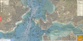
Rade de Lorient, Brittany, France
(hi-resolution Pléiades 1B image extracts : port / Citadelle Vauban)
Dockyard port city at the mouth of the river Blavet and Scorff.
 >>> geolocalization with the Marine GeoGarage <<<
Rade de Lorient, Brittany, France
(hi-resolution Pléiades 1B image extracts : port / Citadelle Vauban)
Dockyard port city at the mouth of the river Blavet and Scorff.

On 2 December 2012, a Soyuz rocket launched the Pléiades 1B very-high-resolution optical satellite built by Astrium for the French space agency CNES from the Guiana Space Centre in French Guiana, less than a year after orbiting Pléiades 1A.
Pléiades 1B was released from the launch vehicle at 02.57 GMT/UTnear its final 694 km orbit.
Pléiades 1B was released from the launch vehicle at 02.57 GMT/UTnear its final 694 km orbit.
The satellite will be phased 180° with Pléiades 1A on the same orbit to form a true constellation offering daily revisits to any point on the globe.
This daily revisit capability brings added value to users of satellite data products around the world. Being able to generate imagery anywhere in the world every day is vital for quick-response applications.
This daily revisit capability brings added value to users of satellite data products around the world. Being able to generate imagery anywhere in the world every day is vital for quick-response applications.
With the Pléiades constellation, conflict and crisis zones or natural disaster areas will be viewable within hours to aid planning of relief and rescue operations.
Daily revisits also allow close monitoring of work progress on civil engineering projects, mining activities and industrial or military operations.
Daily revisits also allow close monitoring of work progress on civil engineering projects, mining activities and industrial or military operations.
And by bringing users twice as much imagery, the Pléiades satellites are ideal for mapping large areas at high resolution, as images are acquired twice as fast to increase the chances of obtaining cloud-free views.
The Pléiades constellation offers users products at a resolution of 50 cm with an imaging swath of 20 km, the widest in its category.
The Pléiades constellation offers users products at a resolution of 50 cm with an imaging swath of 20 km, the widest in its category.
No comments:
Post a Comment