From Maritime Cyprus
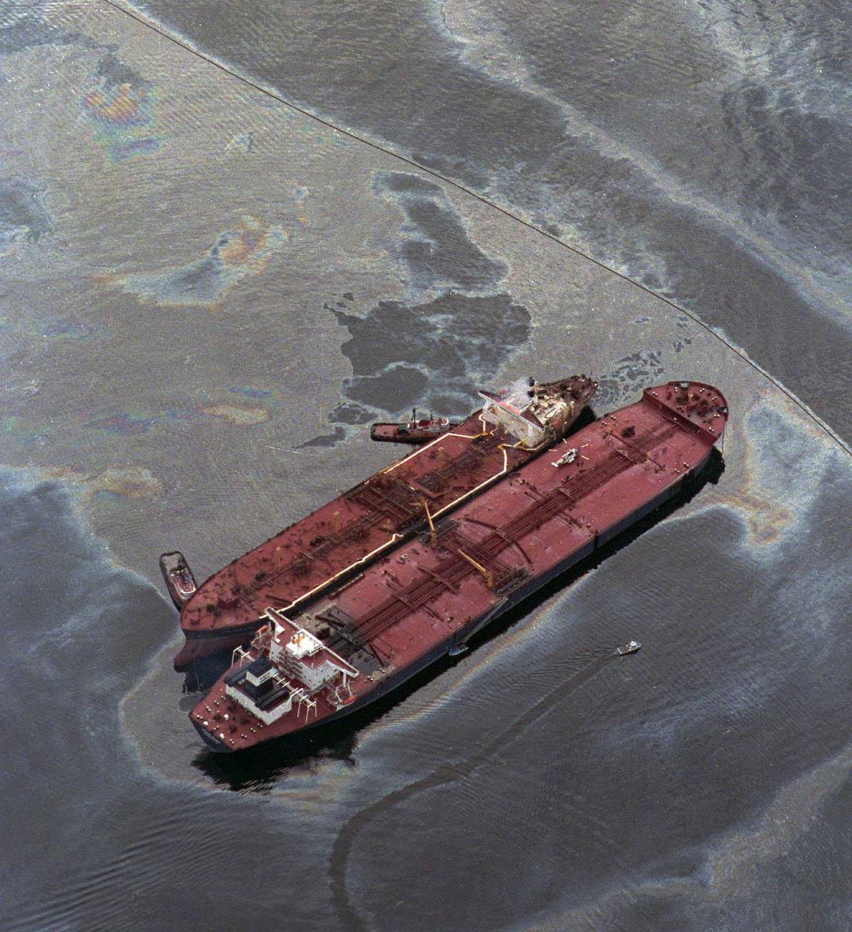
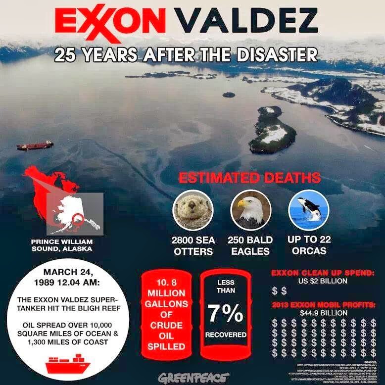
On 24 March 1989, the single-hull tanker EXXON VALDEZ was departing the Port of Valdez, Alaska with a full load of North Slope crude oil (approximately 1.26 million barrels) destined for Long Beach when it grounded on Bligh Reef in Prince William Sound.

EXXON VALDEZ grounded on Bligh Reef in Prince William Sound, Alaska, on 24th March 1989, releasing ~37,000 tonnes of Alaska North Slope crude oil.
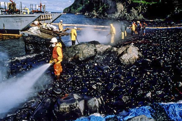
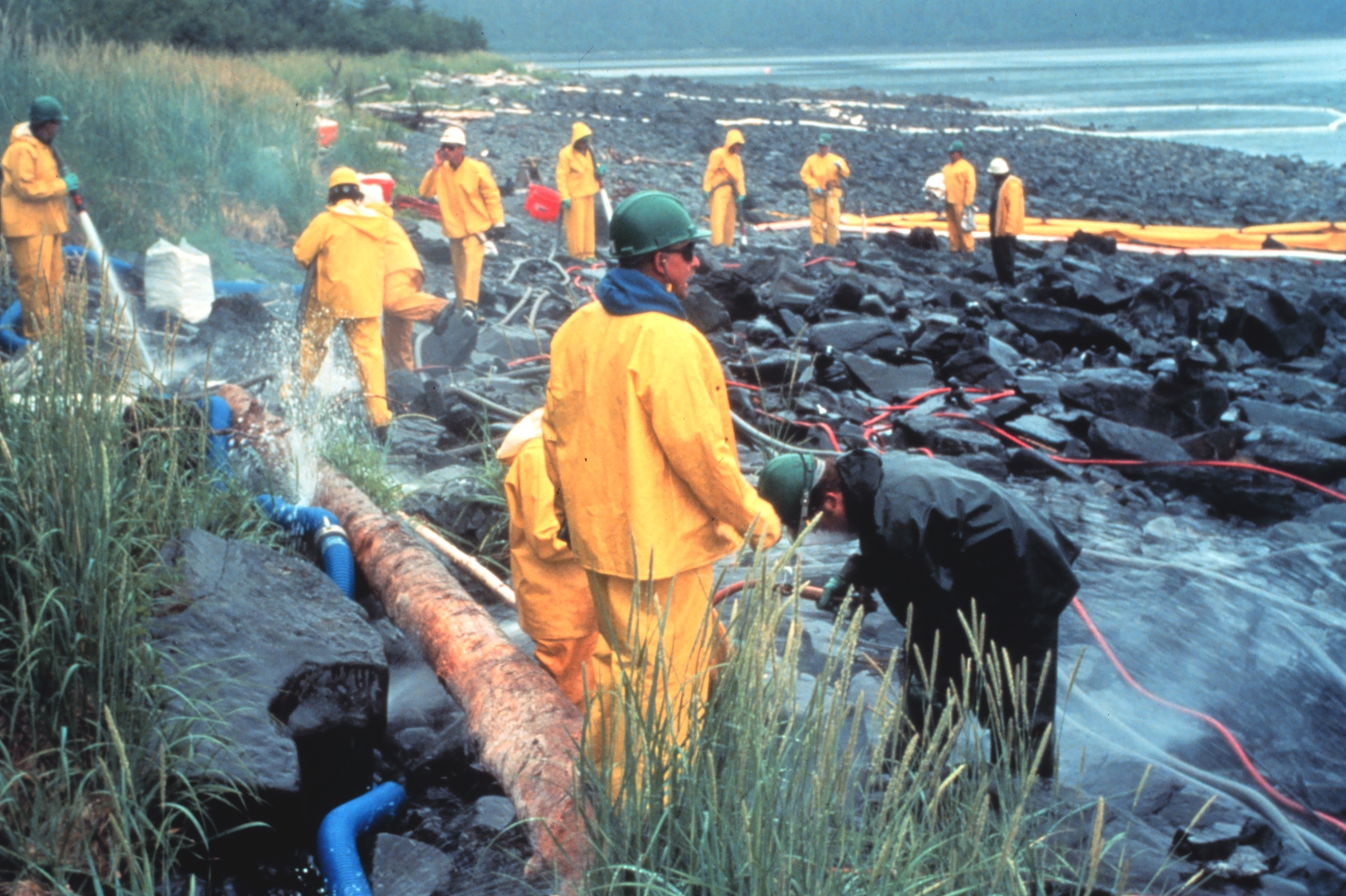
Despite the utilisation of significant numbers of personnel, vessels, boom, skimmers and other resources, the oil spread widely to affect a variety of shores to varying degrees over an estimated 1800Km in Prince William Sound and along Alaska’s south coast as far west as Kodiak Island.
The response was the most expensive ever for a ship-source oil spill, with over 10,000 workers employed at the height of the clean-up operations, many of them in shoreline clean-up, often in remote areas.

The resulting oil spill, while not the largest in US history, was clearly the most important and most expensive ship-source spill.
It engendered much litigation.
It engendered much litigation.
In 1989, a tanker ran aground off the coast of Alaska, causing one of the worst oil spills in United States history.
Nearly 25 years later, the lessons of the Exxon Valdez continue to resonate.
Storyline:
One of the worst oil spills in U.S. territory begins when the supertanker Exxon Valdez, owned and operated by the Exxon Corporation, runs aground on a reef in Prince William Sound in southern Alaska.
An estimated 1.26 million barrels (37,000 tonnes) of oil eventually spilled into the water.
Attempts to contain the massive spill were unsuccessful, and wind and currents spread the oil more than 100 miles from its source, eventually polluting more than 700 miles of coastline.
Hundreds of thousands of birds and animals were adversely affected by the environmental disaster.
It was later revealed that Joseph Hazelwood, the captain of the Valdez, was drinking at the time of the accident and allowed an uncertified officer to steer the massive vessel.
In March 1990, Hazelwood was convicted of misdemeanor negligence, fined $50,000, and ordered to perform 1,000 hours of community service.
In July 1992, an Alaska court overturned Hazelwood’s conviction, citing a federal statute that grants freedom from prosecution to those who report an oil spill.
Exxon spent ~US$2.1 billion in clean-up costs and pleaded guilty to violations of the Clean Water Act, the Refuse Act, and the Migratory Bird Treaty Act.
Exxon itself was condemned by the National Transportation Safety Board and in early 1991 agreed under pressure from environmental groups to pay a fine of $100 million and provide $1 billion over a 10-year period for the cost of the cleanup.
However, later in the year, both Alaska and Exxon rejected the agreement, and in October 1991 the oil giant settled the matter by paying $25 million, less than 4 percent of the cleanup aid promised by Exxon earlier that year.
A civil action by the United States and the State of Alaska for environmental damage ended with payments of ~US$900 million toward restoring natural resources.
A further US$303 million was paid in voluntary settlements to commercial fishermen for lost income due to fish stock damages, to Alaska Natives for lost harvest foods, to seafood processors and employees and to other organisations for lost income, as well as to private landowners for damage to their land as a result of the oil.
With additional fines and damages ~US$4 billion was paid as a consequence of the spill.
A part of this amount was recovered from various insurance companies, including from the vessel’s P&I Club under TOVALOP and from cargo owners through CRISTAL.
The Exxon Valdez oil spill occurred in Prince William Sound, Alaska, on March 24, 1989, when Exxon Valdez, an oil tanker bound for Long Beach, California, struck Prince William Sound's Bligh Reef at 12:04 a.m.[1] local time and spilled 260,000 to 750,000 barrels (41,000 to 119,000 m3) of crude oil[2][3] over the next few days.
It is considered to be one of the most devastating human-caused environmental disasters.[4]
The Valdez spill was the largest ever in US waters until the 2010 Deepwater Horizon oil spill, in terms of volume released.[5]
However, Prince William Sound's remote location, accessible only by helicopter, plane, or boat, made government and industry response efforts difficult and severely taxed existing plans for response.
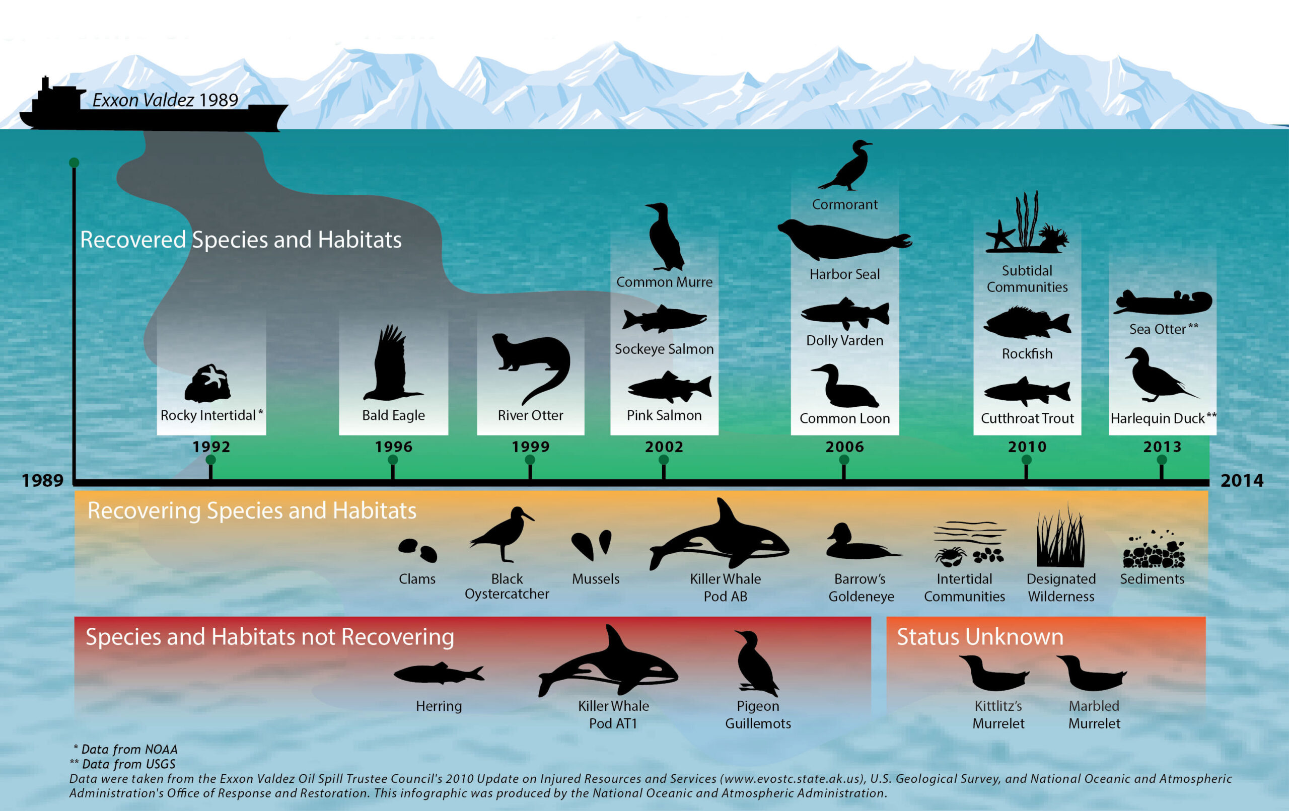
The region is a habitat for salmon, sea otters, seals and seabirds.
The oil, originally extracted at the Prudhoe Bay oil field, eventually covered 1,300 miles (2,100 km) of coastline,[6] and 11,000 square miles (28,000 km2) of ocean.[7]
Exxon's CEO, Lawrence Rawl, shaped the company's response.[8]
According to official reports, the ship was carrying approximately 55 million US gallons (210,000 m3) of oil, of which about 10.1 to 11 million US gallons (240,000 to 260,000 bbl; 38,000 to 42,000 m3) were spilled into the Prince William Sound.[9][10]
A figure of 11 million US gallons (260,000 bbl; 42,000 m3) was a commonly accepted estimate of the spill's volume and has been used by the State of Alaska's Exxon Valdez Oil Spill Trustee Council,[6] the National Oceanic and Atmospheric Administration and environmental groups such as Greenpeace and the Sierra Club.
[5][11][12] Some groups, such as Defenders of Wildlife, dispute the official estimates, maintaining that the volume of the spill, which was calculated by subtracting the volume of material removed from the vessel's tanks after the spill from the volume of the original cargo, has been underreported.[13]
Alternative calculations, based on the assumption that the official reports underestimated how much seawater had been forced into the damaged tanks, placed the total at 25 to 32 million US gallons (600,000 to 760,000 bbl; 95,000 to 121,000 m3).[2]
From: Big Oil: In the Wake of the Exxon Valdez - Natural World - BBC
Following the grounding, Alaska Governor Jay Hammond authorised the creation of the Alaska Oil Spill Commission in 1989 to examine the causes of the spill and issue recommendations on potential policy changes.
Fifty of these recommendations formed the basis for the Oil Pollution Act bill introduced into the legislative process in March 1989 by congressman Walter B. Jones, Sr.
The bill was signed by President Bush on 18th August 1990, officially enacting the Oil Pollution Act of 1990 (OPA 90), which mandated double hulls for new tankers, response plans, and a number of other remedial measures.
OPA 90 also significantly changed the liability and compensation scheme for oil spills in US waters.
The amount of oil entering waters of the United States from ships drastically decreased following implementation of OPA 90.


.jpg)


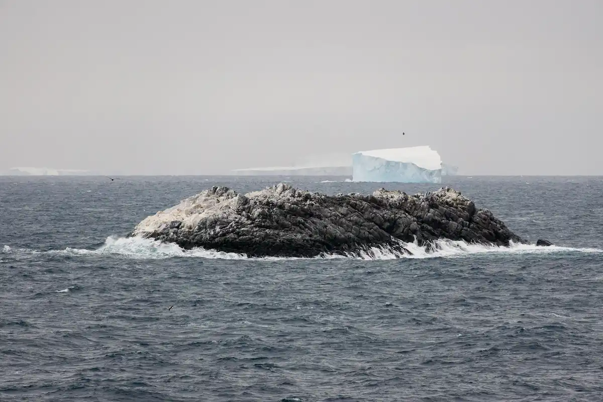 Another view of the new island.
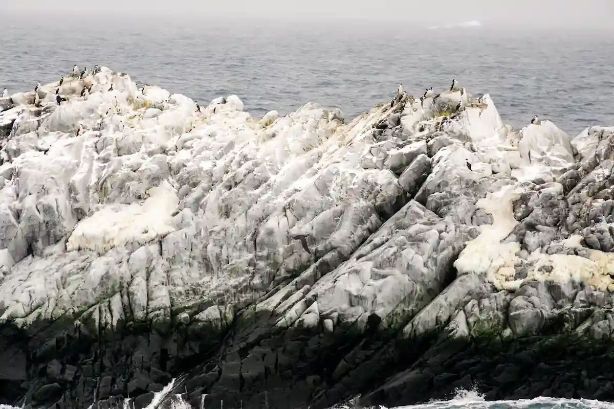 Detail view of the new island and its “inhabitants”.


