The United States successfully claimed an additional one million square kilometers beneath the ocean, expanding its Extended Continental Shelf (ECS) boundaries.
Yes, it’s like America just bought a new basement, one that is almost 60% the size of Alaska.
Mead Treadwell, former lieutenant governor of Alaska and chair of the U.S. Arctic Research Commission, helps us understand the situation.
It’s not quite the purchase of Alaska, but the new area of land and subsurface resources under the land controlled by the United States is two Californias larger,” Treadwell explained.
The Extended Continental Shelf (ECS)
Picture the ocean like a multi-story building that starts at a country’s shoreline. International law gives coastal states clear rights out to 200 nautical miles.
That is the “main floor” of this hypothetical building.
The Extended Continental Shelf (ECS) is what comes next.
It covers the seabed and the rocks beneath it beyond that 200-nautical mile line.
This part of our hypothetical is more like the building’s underground levels than extra living space.
A country doesn’t gain new rights to the water column in that area, but it can claim rights to the resources in the seabed and subsoil if it can show the seafloor is a natural continuation of its land territory.
Under the rules, a coastal state can set the outer edge of its continental shelf as far as 350 nautical miles from its baseline.
In some cases, it can go 100 nautical miles beyond the 2,500-meter isobath, which is a line that traces where the ocean is 2,500 meters deep, but only if the science supports it.
Legality of ECS claims
UNCLOS Article 76 provides the playbook for drawing the continental shelf beyond 200 nautical miles. It explains what evidence counts, how to use geology and seafloor shape to justify an outer limit, and which constraints cap how far the line can go.
The Commission on the Limits of the Continental Shelf (CLCS) acts as the technical referee.
It reviews a coastal state’s submission and checks whether the methods and data meet the standards.
The commission includes specialists in fields like geology, hydrography, and oceanography, because these claims rise or fall on the science.
Claiming an Extended Continental Shelf
A state can’t just point at a map and declare victory.
It has to build a case, document it, and defend it with evidence that holds up under expert scrutiny.
Coastal states start by collecting data through seafloor surveys.
They use tools like seismic profiling, sediment sampling, and detailed bathymetric mapping to show what the seabed looks like and how it connects to the country’s landmass.
After that, they assemble a formal submission.
This package typically includes charts, maps, coordinates, and technical reports that explain the data, the methodology, and the proposed outer limits.
Then the CLCS reviews the submission in depth.
The commission tests the scientific reasoning and may ask questions or request clarifications.
It ultimately issues recommendations.
Those recommendations don’t automatically settle political disputes, but they carry real authority because they reflect a thorough, expert-driven evaluation of the evidence.
Twenty years of hard work
The U.S. began its quest for an ECS back in 2003.
This effort, which required teamwork between the U.S. State Department, the National Oceanic and Atmospheric Administration (NOAA), and the U.S. Geological Survey (USGS), was no easy task.
It took them twenty years and involved a massive data collection initiative, but it paid off, big time.
On December 19, 2023, the State Department announced new geographical coordinates of the U.S. ECS, adding massive chunks of territory in the Atlantic, Arctic, Pacific, and more.
The United States and UNCLOS
How might the U.S. attempt to use these rules to further expand the reach of U.S. territory under the Trump administration?
The relationship between the United States and the United Nations Convention on the Law of the Sea (UNCLOS) is complicated, to say the least.
While UNCLOS is often referred to as the “Constitution for the Oceans,” governing everything from maritime boundaries to resource rights and environmental standards, the U.S. has never actually ratified the treaty, even though it played a significant role in drafting it back in the 1970s and 1980s.
There are worries about issues like sovereignty, naval operations, and financial commitments that have created some major roadblocks.
Some senators fear that joining the treaty would mean giving up U.S. rights to the International Seabed Authority and could restrict access for U.S. companies to underwater resources.
On the flip side, military leaders, especially from the U.S. Navy, are all for ratification, arguing that it would help the U.S. tackle excessive maritime claims by other countries and secure navigational freedoms.
Supporters of ratifying UNCLOS believe that joining would boost U.S. influence in shaping global maritime rules and give legal certainty for U.S. claims, especially regarding the Extended Continental Shelf (ECS).
Even though the U.S. isn’t a formal party, it already follows many of the convention’s rules, using its provisions to back up territorial claims and assert navigation rights in international waters, like the South China Sea.
Science of exploration
This ambitious venture required a scientific odyssey of epic proportions.
The areas encompassed in this claim include the Arctic, the east coast Atlantic, the Bering Sea, the west coast Pacific, the Mariana Islands, and two regions in the Gulf of Mexico.
Brian Van Pay, Project Director for the State Department, explained further, saying, “Forty missions at sea, going to areas that we’ve never explored before, finding entire seamounts we didn’t even know existed.”
Scientists spent the equivalent of over three years charting new territory; using sonar mapping, geological sampling, and sediment layer analysis.
The outcome, as Van Pay notes, was a submission that aligns with the 1982 United Nations Convention on the Law of the Sea (UNCLOS) — the legal framework for this claim.
Importance of UNCLOS and ECS
The implications of this move are multifold.
For starters, the U.S. now has the right to control and potentially exploit resources like oil, gas, and minerals in the expanded territory.
However, it doesn’t mean they can suddenly start fishing further off the coast or start patrolling the new water regions.
It’s more like the U.S. government won the mineral rights to some underwater property.
The claim has been shaped carefully to avoid stepping on the toes of other nations, particularly Russia. But there might be a bit of an overlap with Canada, which may call for future diplomacy.
The biggest one of these, as mentioned above, is the lack of a formal ratification of UNCLOS by the U.S. Senate.
This gap could potentially limit the international legal weight of the claim.
Moreover, the claim’s validity is dependent on the robustness of the science backing it.
According to Treadwell, “If somebody came back and said, ‘Your science is bad,’ I think the United States would listen. But I don’t think science is bad. I think we’ve had very good science.”
Managing the Extended Continental Shelf
There’s more at stake than just economic gain.
The move also widens the U.S.’s jurisdiction to enforce environmental regulations effectively and protect fragile marine ecosystems from unchecked exploitation.
However, balancing these ecological responsibilities with economic interests will prove to be a tricky task.
But, hey, isn’t that part of the thrill?
As over 75 countries have already defined their ECS boundaries, it’s clear that the world is entering a new era of ocean governance.
So, will this new territory lead to a scramble for resources, or will it enhance cooperation in managing and protecting the world’s oceans? Let’s not get ahead of ourselves.
For now, America has made a bold move, and the rest of the world is watching.
One thing is for sure, though: how we navigate these waters will affect not only our economy but also the health of our oceans, the climate, and our future.
A fishing boat navigates around icebergs that broke off from the Jakobshavn Glacier and are floating in Disko Bay on March 10, 2025, in Ilulissat, Greenland. Joe Raedle | Getty Images News | Getty Images
President Trump has said repeatedly that he wants the United States to control Greenland, refusing to take military action off the table and declaring that he will make the semi-autonomous Danish territory part of the U.S. "one way or the other."
Mr. Trump says the U.S. needs to control the vast, largely frozen island that sits mostly inside the Arctic Circle for security reasons, accusing China and Russia of trying to take it over instead.
Greenland's own democratically elected leaders have rejected any U.S. takeover, with the island's government calling it something they "cannot accept under any circumstance."
But the physical location of the island on the map — and the sea ice melting around its borders — is also of vital importance.
New routes around the globe
Melting Arctic sea ice has created more opportunity to use northern shipping routes — allowing logistics companies to save millions of dollars in fuel by taking much shorter paths between Asia and Western Europe and the United States.
Northern routes were long only passable in warmer months.
CBS News
There are a couple primary routes through the Arctic becoming more viable, the Northern Sea Route (NSR), which follows Russia's roughly 15,000-mile northern border.
That path doesn't bring ships too close to Greenland, and Russia and China have agreed to develop the route together, and have been making greater use of it in recent years.
A Russian commercial vessel, aided by an icebreaker, first traversed the NSR in the winter in February 2021, proving it was possible.
The other route, called the Northwest Passage, comes much closer to Greenland's coastal waters and is more likely the path the Trump administration is concerned with.
The other, longstanding way to get goods from ports in Russia or the manufacturing powerhouses of East Asia is to go south. But that course, through Egypt's Suez Canal, is about 3,000 miles longer.
According to the Arctic Institute, compared to the Suez Canal route, the Northern Sea Route can save shippers as much as 50% in costs, considering fuel and other expenses, by reducing the distance from Japan to Europe, for instance, to only about 10 days compared to the roughly 22 it would take to sail around the southern tip of Africa and then through the Suez Canal.
A 2024 analysis by the Middlebury Institute of International Studiesalso said the northern route would shave about 10 days of a similar journey from Shanghai, China, to Rotterdam in the Netherlands.
As sea temperatures continue warming and winter ice cover shrinks, shipping traffic via the north is likely to increase, so control over that passage — and the long Greenlandic coastline that it skirts — will be of greater importance.
The U.S. National Oceanic and Atmospheric Administration shared graphs in 2022 predicting the new routes that would become available to regular tankers around Greenland over the coming decades.
Graphics shared by the U.S. National Oceanic and Atmospheric Administration in 2022 show the sea routes through the Arctic that are expected to become viable to regular vessels (in blue) and polar-class vessels (in red) around Greenland over the coming decades.
NOAA
NOAA's modeling shows a dramatic increase in viable journeys for both polar-class vessels fortified to forge through sea ice, and normal open water-faring ships.
The agency even predicts that by 2059, it will likely be possible for a polar-class vessel to sail the most direct route, right across the North Pole, as the formation of sea ice reduces further.
The UK’s Maritime & Coastguard Agency is reporting a busy night and efforts on Friday, January 9, to track containers after a severe winter storm crossed the region around the English Channel overnight. Warnings were posted for shipping as containers went overboard near the Isle of Wight.
Looking Back on Storm Goretti 🌀: Record Winds, Snow, and Disruption
Storm Goretti, the first named storm of the 2026 European storm season, swept across the UK and parts of Western Europe on 8–9 January. What made Goretti remarkable wasn’t a single extreme factor, but a… pic.twitter.com/SrRGcy7NLH
In meteorological terms, the storm became what is known as a bomb cyclone, where the storm rapidly intensifies.
It, however, left local areas surprised by the ferocity.
There were reports of wind gusts of 73 mph at Needles on the western side of the Isle of Wight.
At Portland, the winds were measured at approximately 65 mph, while in parts of Devon and Cornwall the winds reached 99 mph.
There were widespread reports of flooding, with the Portland Beach Road closed for hours due to high waves, while parts of the region reported sleet and even snow.
Elsewhere, 22 mm of rain was recorded in the Channel Islands.
The storm grew in intensity in the evening, peaking around 2300 local time.
The winds and waves, however, continued much of the night.
It was around the peak of the storm that the MCA reported it received a call about containers going overboard.
Around 2310, it was informed that an unnamed ship had lost 17 containers near Nab Tower and the Isle of Wight.
While the first report was being processed, a second vessel reported it had lost seven containers about 16 nautical miles south of St. Catherine’s Point.
The MCA said it had fixed-wing aircraft searching on Friday for a total of 24 containers believed to be in the water.
Ships were being warned of the danger.
The MCA was working with the shipping companies to determine the contents of the boxes.
Some reports said the first lot was believed to be reefers.
The second lot was thought to be empties, and the MCA said there was a good chance that some of the boxes sank in the high seas.
It emphasized that it is the responsibility of the shipping companies to locate and retrieve the overboard containers.
These losses come just a month after another reefer vessel lost 16 containers in the same general area. Boxes washed ashore and on the beaches, and inland, people were finding bananas.
At last account, 13 of the 16 containers were located, and the others were thought to have sunk in the waterway.
The MCA launched an investigation, noting that one concern was improperly secured containers, or it said that crews sometimes started to remove restraints in anticipation of reaching port to speed the handling.
While the search was continuing for the overboard containers, the weather was also impacting other shipping operations.
Hovertravel to the Isle of Wight was entirely canceled. DFDS was warning of disruptions and delays due to winds and waves for its cross-channel service between Dover and France.
For the eighth year in a row, the world’s oceans absorbed a
record-breaking amount of heat in 2025. It was equivalent to the energy
it would take to boil 2 billion Olympic swimming pools.
SINCE 2018, A group of researchers from around the world have crunched the numbers on how much heat the world’s oceans are absorbing each year. In 2025, their measurements broke records once again, making this the eighth year in a row that the world’s oceans have absorbed more heat than the years before.
The study, which was published Friday in the journal Advances in Atmospheric Science, found that the world’s oceans absorbed an additional 23 zettajoules’ worth of heat in 2025, the most in any year since modern measurements began in the 1960s. That’s significantly higher than the 16 additional zettajoules they absorbed in 2024. The research comes from a team of more than 50 scientists across the United States, Europe, and China.
A joule is a common way to measure energy. A single joule is a relatively small unit of measurement—it’s about enough to power a tiny lightbulb for a second, or slightly heat a gram of water. But a zettajoule is one sextillion joules; numerically, the 23 zettajoules the oceans absorbed this year can be written out as 23,000,000,000,000,000,000,000. John Abraham, a professor of thermal science at the University of St. Thomas and one of the authors on the paper, says that he sometimes has trouble putting this number into contexts laypeople understand. Abraham offers up a couple options. His favorite is comparing the energy stored in the ocean to the energy of atomic bombs: The 2025 warming, he says, is the energetic equivalent to 12 Hiroshima bombs exploding in the ocean. (Some other calculations he’s done include equating this number to the energy it would take to boil 2 billion Olympic swimming pools, or more than 200 times the electrical use of everyone on the planet.)
“Last year was a bonkers, crazy warming year—that's the technical term,” Abraham joked to me. “The peer-reviewed scientific term is ‘bonkers’.”
The world’s oceans are its largest heat sink, absorbing more than 90 percent of the excess warming that is trapped in the atmosphere. While some of the excess heat warms the ocean’s surface, it also slowly travels further down into deeper parts of the ocean, aided by circulation and currents.
Global temperature calculations—like the ones used to determine the hottest years on record—usually only capture measurements taken at the ocean’s surface. (The study finds that overall sea surface temperatures in 2025 were slightly lower than they were in 2024, which is on record as the hottest year since modern records began. Some meteorological phenomena, like El Niño events, can also raise sea surface temperatures in certain regions, which can cause the overall ocean to absorb slightly less heat in a given year. This helps to explain why there was such a big jump in added ocean heat content between 2025, which developed a weak La Niña at the end of the year, and 2024, which came at the end of a strong El Niño year.) While sea surface temperatures have risen since the industrial revolution, thanks to our use of fossil fuels, these measurements don’t provide a full picture of how climate change is affecting the oceans.
“If the whole world was covered by a shallow ocean that was only a couple feet deep, it would warm up more or less at the same speed as the land,” says Zeke Hausfather, a research scientist at Berkeley Earth and a coauthor of the study. “But because so much of that heat is going down in the deep ocean, we see generally slower warming of sea surface temperatures [than those on land].”
Surface temperatures, Hausfather says, are what most directly impact human societies: They have direct effects on weather patterns and most of the ocean life we interact with. But the amount of heat stored in deeper parts of the ocean is a key metric for understanding how climate change is affecting the planet.
“Ocean heat content is in many ways the most reliable thermostat of the planet,” he says. “That’s where all the heat is going—and that's the reason why almost every year we set a new record for ocean heat content, because there's so much heat being absorbed by the ocean.”
The estimates of ocean heating in the paper were created using a mix of mathematical models of ocean warming as well as reams of data on ocean temperatures collected from sites around the world. Humans have been tracking ocean temperatures for a long time; Benjamin Franklin recorded sea temperatures during his transatlantic voyages. In the 1870s, the HMS Challenger expedition—which is largely credited with inventing modern oceanography—took measurements at deeper depths. But regularly measuring temperatures substantially below the surface is a relatively new phenomenon. The study’s earliest data goes back to the 1960s, when some navies began taking measurements of deeper ocean temperatures.
A key tool that revolutionized our understanding of deeper ocean temperatures is the international network of Argo floats, with more than 3,500 robotic buoys that were first deployed in the early 2000s to collect data on oceans around the world. In addition to the Argo floats, the study pulls data from a variety of other sources, including data measured from buoys, ship hulls, satellites—and animals. (“We actually put instruments on mammals that swim under ice, and so we can measure temperatures while they swim,” Abraham says. “They can take measurements where our robots can't go.”)
The study also uses algorithmic models trained on particular sets of ocean data.
“It's really quite impressive that they get such consistent results using multiple datasets,” says Raphael Kudela, a professor of ocean science at UC Santa Cruz who was not involved in the study. Kudela says that studies like these help to hammer home just how much climate change is altering the planet.
“What people often don't grasp is that it's taken 100 years to get the oceans that warm at depth,” he says. “Even if we stopped using fossil fuels today, it's going to take hundreds of years for that to circulate through the ocean. We're going to pay this cost for a very, very long time, because we've already put the heat in the ocean.”
An exclusive economic zone mapped using autonomous systems
The Cayman Islands recently became the first nation to map its entire exclusive economic zone (EEZ) using autonomous systems, marking a significant moment for modern hydrography. Led by Saildrone in collaboration with the UK Hydrographic Office, the mission charted more than 90,000 square kilometres of seabed, from coastal shallows to depths of 7,000 metres. The results highlight new opportunities for the Cayman Islands’ blue economy while demonstrating how uncrewed surface vehicles can deliver large-scale, high-quality data safely and efficiently. In this interview, Brian Connon of Saildrone reflects on the project’s challenges, achievements and wider implications for the region and the industry as a whole.
The Cayman Islands mission used Saildrone’s new production Surveyor, a 20-metre uncrewed surface vehicle equipped with radar, cameras, AIS and machine-learning systems for situational awareness. Its 13-metre wing sail enables wind-powered propulsion, cutting the vessel’s operational carbon footprint by more than 97% compared to traditional survey ships. According to Brian Connon, the integration of Starlink significantly enhanced the mission: “Starlink, particularly seeing how much it improved our ability to bring data ashore in near real time, allowed us to process information and verify data quality much faster.”
Connon saw that Starlink transformed how the team handled data at sea. With the upgraded link, files were automatically named, grouped and transmitted from the vehicle to Saildrone’s Amazon Cloud environment, where automated processing routines immediately began assessing data quality. Another major enhancement was the EM 304 MKII sonar, which extended the vehicle’s mapping capability to depths of 7,000 metres. Although similar to earlier models, the new system offered significantly greater range, and Saildrone’s partner Kongsberg played a crucial role in helping the team unlock its full potential. The mission also benefited from improvements to the sound velocity profiler (SVP) developed with AML Oceanographic; upgrades to the inductively charged system and a shift from Bluetooth to Wi-Fi provided a stronger, more reliable connection.
Navigating Sargassum and hurricanes
The Caribbean’s 2024 Sargassum bloom was unprecedented, repeatedly clogging the profiler as it returned to the vehicle and posing a constant threat to the Surveyor’s operations. “We would try to pull up our SVP, and it would be covered with seaweed and unable to seat properly in its receptacle, so it couldn’t charge,” Connon recalls. “We had to come up with a very creative way of dealing with that, which was a mechanical chopper of the seaweed.”
Beyond Sargassum, the mission coincided with an active hurricane season, forcing the team to develop evasion strategies. “If possible, we tried to stay on survey but in a different area of the EEZ, and that worked a couple of times,” Connon says. “Our pilots were really good at looking ahead and determining the impacts from the hurricanes and manoeuvring the vehicle out of harm’s way if needed.”
Visualization with the GeoGarage platform (NOAA nautical raster charts)
Merged bathymetric dataset around the Cayman Islands displayed over a GEBCO background.
The Surveyor’s wind-propelled design and high-efficiency diesel generator allowed it to endure long-duration missions without refuelling, a significant advantage in remote areas such as the Cayman Islands’ EEZ. “We learned our true operating parameters, our specific swath widths in the depths we were in. Towards the end, we brought another vehicle in so we could have two working and that allowed us to do a comparison too.”
Maritime safety and economic planning
The high-resolution bathymetric data collected by Saildrone is a cornerstone for the Cayman Islands’ blue economy. “The UKHO is processing all this data, and it is their intent to update all of the nautical charts around the Cayman Islands,” Connon explains. “They flew a bathymetric Lidar there in 2018-2020, but the Cayman Islands drop off very quickly so the Lidar doesn’t get very far offshore.”
Connon notes that the new collected data reaches far beyond its immediate use for updated nautical charts. With a complete high-resolution dataset now available, the Cayman Islands can start assessing underwater features in far greater detail, from identifying new fishing grounds to locating coral formations or planning future subsea cable routes. This baseline information effectively unlocks the full potential of the islands’ blue economy. It allows decision makers to examine where new resources might be found, what areas require protection and whether there are archaeological sites worth investigating – all supported by a clearer and more comprehensive understanding of the seafloor.
The mission, which is philanthropically funded by the London & Amsterdam Trust Company Limited, aims to leave a lasting legacy for the Cayman Islands. “I know they’re excited about it as well,” Connon notes.
The Saildrone Surveyor, a 20-metre USV, supports long-duration ocean missions and delivers deep-ocean bathymetric measurements.
From raw data to global contributions
The raw bathymetric, backscatter and ocean profile data are now in the hands of the UKHO. Connon: “What we’ve been doing all along is providing them with datasets, and they’re downloading and putting it into their normal workflow. They’ve been very happy with us on that.” He elaborates on the processing timeline: “It’ll probably be sometime next year before all of that data is fully validated and processed by them. We did have to wait a little in the shallow areas because the tide gauges they had installed for their surveys were taken out by a hurricane. Luckily, the Cayman Islands had put in a storm surge gauge in Georgetown that we could reference and use for the tidal information we needed.”
The mission’s success has broader implications for small island nations. Connon regards this as a very good example of how small island developing states can get their EEZ mapped. While not all states have access to philanthropic funding, it does show what can be done and provides a goal for other nations.
Refining autonomous technology
The Cayman Islands mission was a proving ground for Saildrone’s Surveyor vehicles. “It was a long project that gave us an opportunity to identify challenges or issues and the time to fix them while we were surveying,” Connon notes. “Did that work? Yes, it did. It was really about learning our own capabilities and limitations with respect to these vehicles. It proves that these USVs can do this work. You don’t need an expensive ship to go out there with a lot of people on board.” He adds: “What I would love to see is someone with a ship and an AUV or an ROV looking at our data and saying: ‘Hey, look at that, that’s a pretty interesting feature. We should go investigate that further.’”
“We’re essentially doing a kind of reconnaissance, an exploratory survey from the surface,” Connon explains. “We did the same thing for NOAA in the Aleutian Islands – they brought their ship in afterwards and deployed ROVs to the sites they’d identified in our data. What we’re really showing is that the robots can take on the mapping and the crewed vessels can focus on the detailed follow-up.”
Bathymetric data collected by the Saildrone Surveyor USV over the 60 Mile Bank, Cayman Islands. Technology, sovereignty, stewardship
As autonomous systems take on a larger role in ocean mapping, they bring not only technical benefits but also questions about data ownership and responsible use. During the Cayman Islands mission, Brian Connon returned several times to the principle that national sovereignty must remain central. “The data we collect belongs to the Cayman Government,” he says. “It’s up to them to decide how they’re going to distribute that. Autonomous systems can help and provide all the information, but it should belong to that country. That’s the path we’re on, and most of the autonomous companies I know operate in a similar way.”
That position shapes how Saildrone advises its partners. Connon describes the balance between contributing to global initiatives and safeguarding strategic interests. “We’re encouraging them to share that with Seabed 2030,” he notes. “However, this may be at a resolution that’s good for Seabed 2030, but not the full resolution because that is something that is valuable to the nation.”
Evolving role of hydrographers
Looking ahead, Connon sees autonomy, AI and machine learning reshaping the workflow of hydrography. The trajectory is clear to him: “The goal is to have autonomous systems collecting data and either processing it on the edge, on the vehicle itself, or sending it into a cloud where an AI/ML system is processing that data.”
Yet technological progress also prompts questions about the profession itself. Connon acknowledges these concerns with a familiar example. “I get this question a lot: ‘Is the hydrographer going to be out of work?’ And I think the answer really is no, because we’re going to be designing control and monitoring systems that allow a person to monitor more than one vehicle.”
He underscores that expertise remains essential, regardless of how much automation enters the workflow. “The fundamental education and training that a hydrographer has still applies. We still have to understand how that data is being acquired. AI and machine learning will be great on the data, but if the data being collected isn’t collected properly, if you’re not taking into account all those things, it doesn’t matter.”
He expects the way hydrographers are trained to shift, with greater emphasis on data handling and smarter approaches to collection. At the moment, autonomous systems are not formally included in IHO Category B programmes unless an institution chooses to add them, but: “I believe that will change. In the future, some hydrographers may carry out meaningful work without ever stepping aboard a vessel – an idea that may raise eyebrows among traditionalists yet could open the door for people who are unable to go to sea but still want to contribute. It’s going to be a change,” he says, “but a positive one.”
That shift will require new approaches to professional development. “I think it is going to be a change. We’re looking at things like microcredentials that you can offer as a continuing education credit to a hydrographer on various things – whether it’s the sonars, USVs or using Lidar.”
80m-gridded bathymetry of the 12 Mile Bank, shown alongside a depth profile across the feature.
Conclusion
The Cayman Islands mission stands as a significant marker in the evolution of autonomous hydrography, showing how USVs can operate in demanding conditions while delivering consistent, high-quality results. For small island nations as well as coastal communities, these systems offer a practical way to map and manage marine environments at a scale that was previously out of reach.
Brian Connon views the mission as a defining moment for autonomous ocean mapping. Operating in Sargassum-choked, hurricane-exposed waters highlighted the maturity and resilience of the technology. “This mission shows what only autonomous surface vehicles can achieve today: mapping at a level of detail and endurance that was previously unattainable, even in some of the world’s most challenging waters. It points to what’s now possible for nations looking to understand and manage their ocean spaces.”
Looking ahead, Connon believes that advanced technology and human judgement will increasingly reinforce one another. “The ocean is unforgiving, yet the mission’s success demonstrates how technology and human expertise can collaborate to explore and protect our oceans.” Autonomous systems, he adds, will play a central role in mapping EEZs: “They’re not just the future – they’re the present.”


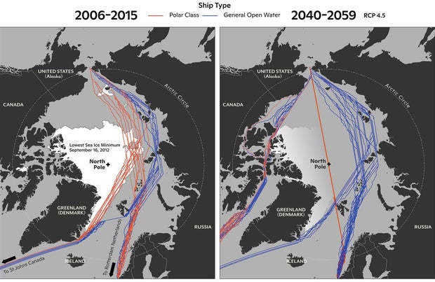 Graphics shared by the U.S. National Oceanic and Atmospheric Administration in 2022 show the sea routes through the Arctic that are expected to become viable to regular vessels (in blue) and polar-class vessels (in red) around Greenland over the coming decades.
 Shipping near the Isle of Wight and elsewhere in the English Channel was impacted by a severe winter storm (European Space Agency file photo)
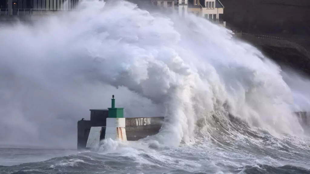


 Merged bathymetric dataset around the Cayman Islands displayed over a GEBCO background.
 Bathymetric data collected by the Saildrone Surveyor USV over the 60 Mile Bank, Cayman Islands.
 80m-gridded bathymetry of the 12 Mile Bank, shown alongside a depth profile across the feature.