The date line, it's somewhat of a border, but who is in charge of it?
Johnny Harris explains the International Date Line
and discovers that Google Maps has incorrectly delineated the boundary.
GeoGarage Time Zone API : for maritime areas
and discovers that Google Maps has incorrectly delineated the boundary.
From Sovereign limits by Tim Montenyohl
Not long ago, our Director of GIS was working on a project in the Pacific when he started complaining about the geometric lines commonly used to divide up island nations.
You’ve definitely seen them if you’ve ever looked at the Pacific, or called up an International Date Line map.
But where do those lines come from?
But where do those lines come from?
Kevin wanted to know—and so did I.
Suspecting the lines may be sourced from time zones, I peeked at a time zone map and realized something: pretty much every existing map of the International Date Line is wrong.
Suspecting the lines may be sourced from time zones, I peeked at a time zone map and realized something: pretty much every existing map of the International Date Line is wrong.
To be clear, the International Date Line is made up, with no true established standard.
It’s still however standardized enough that Natural Earth has a shapefile of it, which seems to match every other version one can find.
Existing maps of the International Date Line are accurate in terms of dividing land up into proper time zones, but it completely ignores maritime sovereignty.

From Wikipedia, so it must be true
Sovereignty is the driving force behind time zones, and therefore the International Date Line.
If American Samoa decides it wants to switch from observing UTC–11 to observing UTC+13, that would redefine the International Date Line (it would also basically abolish a whole day for them).
But American Samoa isn’t going to specify a different time zone for their maritime space.
(As a sovereign nation they could, but for what purpose?)
When a nation adheres to a specific time zone, it’s pretty safe to assume that it also applies to its maritime space.
So I came up with a thought experiment: What if we redefined the International Date Line using maritime sovereignty?
Rethinking the Map
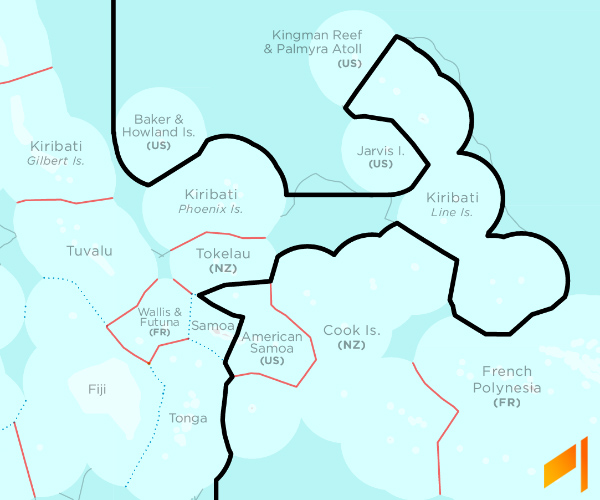
This wasn’t as clear-cut as I thought it would be. There’s a little problem with Kiribati. As a nation, it’s clumped into three groups; Gilbert Islands, Phoenix Islands, and Line Islands.
The Line Islands are basically a time zone enclave, being well within the Western hemisphere, but observing a very Easternly UTC+14.
(Kiribati is actually the only country that observes the UTC+14 time zone.)
It makes sense, however, that the island nation as a whole would want to be on the same day.
The existing International Date Line has a somewhat awkward bridge between the Phoenix Islands and the Line Islands.
The existing International Date Line has a somewhat awkward bridge between the Phoenix Islands and the Line Islands.
I redrew the Date Line using maritime boundaries and Exclusive Economic Zones (EEZs), and maintained that awkward bridge.
The Date Line’s awkward bridge, now with more detail!
I can’t call this experiment over after drawing this sovereignty-based map. See those gray hairlines in the above image?
Those are Extended Continental Shelf (ECS) submissions.
These are created unilaterally, so it’s questionable how much weight should be given to them.
The problem with my new International Date Line is that the Awkward Bridge goes right across the ECS claim of Cook Islands, which is on the other side of the International Date Line from Kiribati. Alternatively, I can make an International Date Line map that recognizes ECS submissions, but that means redirecting the bridge.

Including ECS submissions, Awkward Bridge is… still awkward
This map gives full weight to countries’ ECS submissions (remember, they’re questionable).
Regardless of validity, those submissions should probably be on the same side of the International Date Line as the submitting nation.
So Awkward Bridge now reaches over Jarvis Island as opposed to running below it. But does Awkward Bridge even need to exist?
If it didn’t, the Line Islands would truly be a Date Line enclave, which I’d like to point out, is also an awkward situation.

“Existing” International Date Line vs. my 2 new versions
Where Is the Line, really?
I realized a fair amount from going through this exercise.
While the Prime Meridian feels sacrosanct, the International Date Line isn’t a meridian; it’s pretty arbitrary.
Present convention is to ignore maritime sovereignty, for the sake of clean, angular lines on a map. That’s likely due to the fact that time zones, as a concept, pre-date the notion of maritime sovereignty as defined by UNCLOS.
As lines change, maps need updating. Looks like time zones and the International Date Line need new maps.
No comments:
Post a Comment