from Raremaps
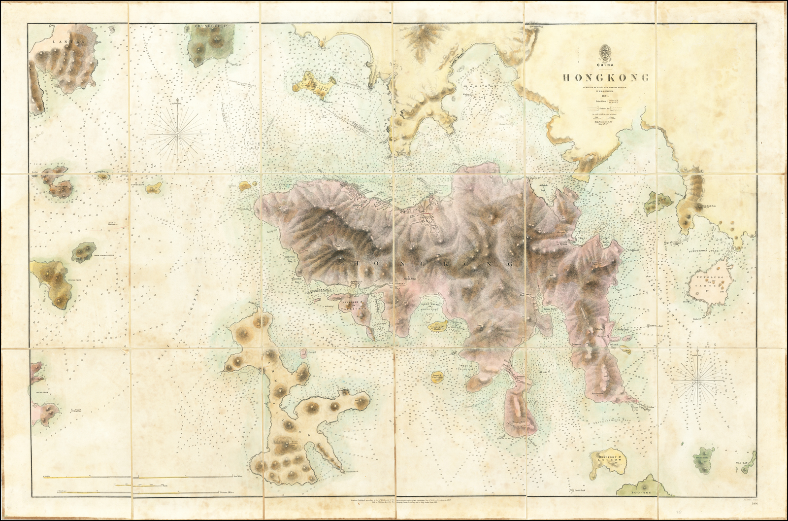
Early edition of the first printed map of Hong Kong, first published in 1843 by the British Admiralty Chart of Hong Kong, based upon the surveys of Sir Edward Belcher.
Belcher's survey is the first large format map or sea chart of Hong Kong.
On January 26, 1841, Edward Belcher and his men were the first of the British fleet to land on Possession Point at the north shore of Hong Kong for the British Crown.
He subsequently made the first British survey of Hong Kong harbor.
While the map is dated 1841, the first state of the map was not published until May 1843.
In comparing the map to the 1846 state, we note changes in the following areas:
Naming and improved coastline for Taihowan Bay and Sandy Bay
Staunton's Valley named and improved
Settlements in Victoria Bay are nearly doubled
Settlement shown in Happy Valley
Taitoo Id. is now Taitoo or Junk Island
Adrich Bay, Sywan Bay and Little Sywan Bay are named with better detail along the coastline.
Shicko and Tootewan are shown.
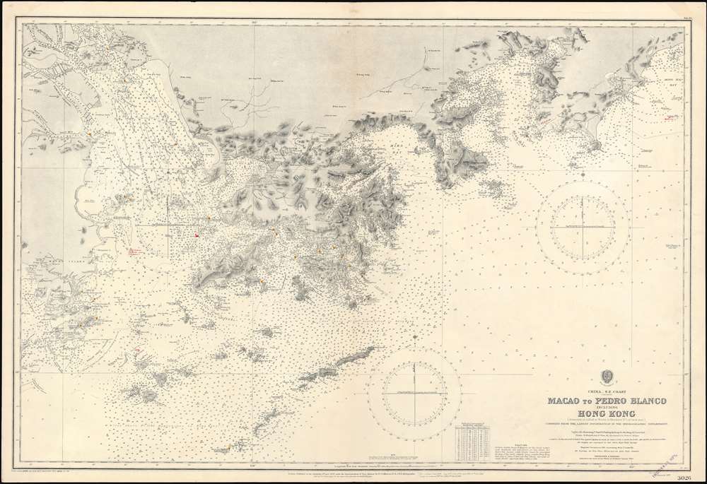
1929 (dated) 27.5 x 40.5 in (69.85 x 102.87 cm) 1 : 186000
A rare 1929 British Admiralty nautical chart or maritime map of Hong Kong and vicinity. Centered on Hong Kong, the map includes Kowloon and the New Territories, it extends west as far as Macao, and east to Hong Hai Bay.
The chart exhibits manuscript updates in a practiced hand.
Census and Publication HistoryThis chart was first published in 1899, with the present example being updated to 1929.
In the 1960s, the U.S. Navy issued a similar chart of the same title.
The map appears in the OCLC in an 1899 and a 1960 edition, but no institutional holdings are identified.
We have been able to trace no other examples of the present edition and no verifiable examples of earlier editions.

surveyed by Captn. Sir Edward Belcher in H.M.S. Sulphur 1841
Hydrographic Office of the Admiralty
An iconic chart of the utmost importance, this is the 1890 issue of Edward Belcher’s survey of Hong Kong and vicinity.
This was the first British survey of Hong Kong and played a significant role in Great Britain’s acquisition of the Crown Colony.
The chart covers all of Hong Kong Island as well as the Kowloon Peninsula and, either in part of full, the adjacent islands of Lan Tao, Peng Chau, Hei Ling Chau, Lamma, Sheung Sze Mun, Po Toi, and Tung Lung Chau.
It offers impressive detail to the level of individual buildings, especially in the vicinity of Victoria, Central, and on the Kowloon Peninsula.
The chart also features innumerable soundings in fathoms, the locations of rocks and other hazards, and other aids to navigation.
An inset map of Fotaumun Pass or Tathong Channel appears in the upper right quadrant.
The chart was the product of surveys overseen by Edward Belcher (1799-1877), a British naval officer, scientist, explorer, and marine surveyor active in the middle part of the 19th century.
Belcher surveyed Hong Kong Island and Harbour after landing the bombing and surveying vessel H.M.S. Sulphur on Possession Point on January, 26, 1841.
Coming at the height of the First Opium War (1839–42), Belcher’s was the first force to land on and take possession of Hong Kong for the British Crown.
He may have been unaware of the long term significance of his conquest, but he was certainly a keen enough observer to recognize the island’s strategic significance and commercial potential.
As such, his impressive chart, first published in 1843 and updated many times thereafter, set the standard upon which most subsequent nautical charts of Hong Kong were based well into the 20th century.
Indeed, I find in OCLC (#905910153) an example printed in 1960!
The chart was intended for hard use at sea, and all early editions are consequently rare.
This example of the chart was owned by the Thomas Reese Anderson, a native of the ship-building town of Sackville, New Brunswick and captain of the 1438-ton Albania of the Taylor Brother’s fleet.
It was by far the best and most up-to-date depiction of the region available, and Anderson would have obtained it in advance of an 1891 charter voyage from New York to Yokahama.
Following the voyage he retired from sailing and became a man of means in his hometown of Sackville, New Brunswick.
He invested in various businesses including a railroad line, which ultimately led to his death in 1918 after being struck by a shunting train engine in 1918.

Hong Kong island with the GeoGarage platform (NGA raster chart)
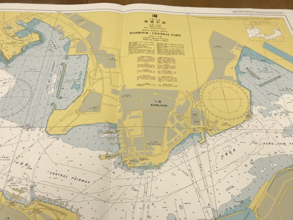
The HKHO produces 12 nautical charts for different parts of the Hong Kong waters.
The picture shows a nautical chart of the central part of the harbour.
Links :
- GeoGarage blog : Collector’s 400 years of China maps and nautical charts up for sale – there’s not a nine-dash line to be seen
No comments:
Post a Comment