Photo: Hu Xujie
From Global Times by Deng Xiaoci
Navigation, positioning network reduces China’s reliance on GPS
"Ten, nine, eight…three, two, one. Launch."
The calm voice of 01 Commander Yin Xiangyuan in the Liangshan mountain valley in Southwest China's Sichuan Province was soon overwhelmed by the thunderous boom of the rocket launch on Tuesday.
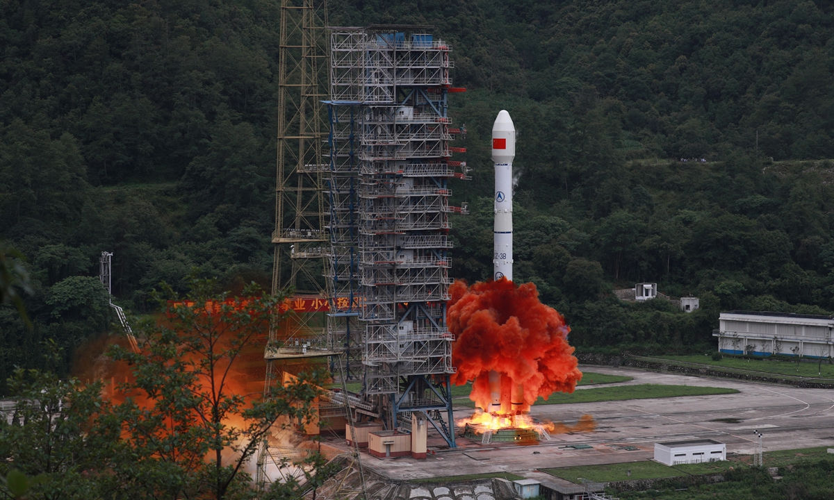
Carrying the last satellite of China's domestically developed BeiDou Navigation Satellite System, or BDS, the Long March-3B launch vehicle blasted off from the Xichang Satellite Launch Center Tuesday morning.
After being in flight for around half an hour, the spacecraft, the third geostationary Earth orbit (GEO) satellite and 30th of the third-generation series of the BeiDou system, or BDS-3, successfully entered its planned orbit, marking the completion of the global geolocation network, which is also China's largest space-based system and one of the four global navigation networks.
The three others are the US' GPS, Russia's GLONASS and the European Galileo.
The launch of the final satellite of China's indigenous BeiDou system was previously scheduled for June 16, but was delayed after technical problems were found with the Long March-3B rocket in pre-launch tests.
Space launches have always been full of challenges, and sometimes faced high risks of failure.
The postponement of the final BeiDou launch and resumption after resolving the problems once again shows that Chinese space scientists uphold the scientific spirit, allowing zero errors at any stage of the mission, insiders said.

Photo: Courtesy of CALT
World-class performance
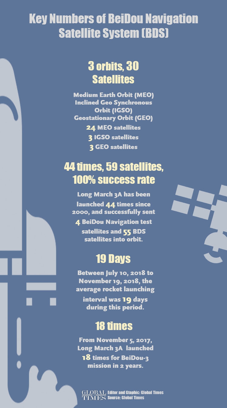
The latest GEO satellite is the 55th BDS system, and will work with other members of the network, allowing global users to access high-accuracy navigation, positioning and timing, as well as communication services.
Compared to previous generation series, the constellation of BDS-3 with an array of 30 satellites on three different orbit planes - three at the GEO, three at the inclined geosynchronous orbits, and 24 at the medium Earth orbit--have a higher bandwidth, enabling enhanced communication capability and carrying more accurate and stable atomic clocks to improve the precision of timing and navigation services, according to the project contractor, China Academy of Space Technology, under the state owned space giant China Aerospace Science and Technology Corporation (CASC).
The BDS-3 also possesses better messaging capabilities, increasing its unique short message service capacity from 120 Chinese characters to 1,200 per message, and the higher communication bandwidth also expands the number of users from 500,000 to 5 million.
BDS-3 is also capable of providing precise point positioning services (PPP) with a decimeter-level dynamic accuracy and centimeter-level static accuracy--meaning, it can support applications such as auto-pilot for vehicles and precision docking of ships.
Yang Changfeng, the chief architect of the BDS, told the Global Times on Monday that China's BDS is compatible with the US' GPS, Russia's GLONASS and Europe's Galileo, and users worldwide can freely choose from the four systems with the best signal from the global navigation satellite systems with over 100 satellites.
The chief architect said the BDS has satellites on three orbit planes in the Asia-Pacific region, which makes it more capable of resisting disturbances from occlusion, even in such environments with multi-layer surfaces in urban areas and in forests.
Users in low latitude areas in the Asia-Pacific region can enjoy non-stop navigation services from the BDS under these circumstances, and the accuracy of the BDS service is just as good as that of the US' GPS, and of world-class quality globally, Yang noted.
Yang also told media on Tuesday that the completion of the BDS-3 constellation marks a step forward in China's advance to space power.
The mission will complete the BDS-3 system, which, according to Wu Di, a scholar at the satellite positioning technology center of Wuhan University in Central China's Hubei Province, will further enhance the quality of services of the system for global users, with more satellites above every corner around the world, which will bring stronger signals.
The China Satellite Navigation Office on Tuesday said much of the world have started using the BDS.
The office told the Global Times in a Tuesday statement that the United Nation Office for Outer Space Affairs sent a special video to extend congratulations for the successful launch, and also spoke highly of the BeiDou system's contribution to the world's social and economic development.
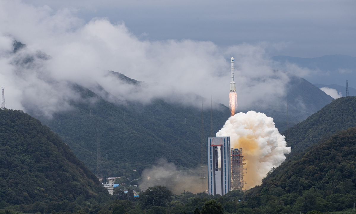
Carrying the last satellite of China's domestically developed BeiDou Navigation Satellite System, or BDS, the Long March-3B launch vehicle blasts off from the Xichang Satellite Launch Center on Tuesday morning.
Photo: VCG
Key strategic assets
People's Daily on Tuesday released a special video to illustrate why China has chosen to develop such an indigenous system when the US GPS is already in place and corners most of the civilian market.
The answer it offered was that while Chinese users have been benefiting from the GPS, the US system is not ours, and the video pointed out that GPS signals were developed by the US Air Force in the 1970s.
And owning our own indigenous navigation satellite system is the best way to resist being controlled by others.
"The manipulation of the US signals would paralyze any weapons solely relying on the GPS, which would lead to unbearable outcomes," the video stressed.
The US GPS and Russia's GLONASS were primarily designed for military use with civilian use as a by-product, Song Zhongping, a military expert and TV commentator, told the Global Times on Tuesday.
In military conflicts, having such key strategic assets would make a huge difference, Song noted.
For example, the high accuracy BDS navigation could guide the launch of missiles, and combatants could use the precision timing service BDS offers to effectively coordinate, the military expert said.
Infographic: GT
Infographic: GT
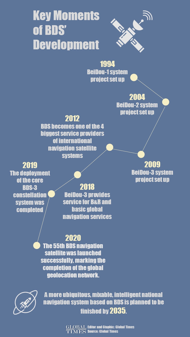
Hard work of generations
China began researching and developing the country's indigenous satellite system in 1994 to reduce its reliance on foreign networks, especially under the complicated external environment.
The first BeiDou satellite entered orbit in 2000, and started providing positioning, navigation, timing and messaging services to users in China and in the Asia-Pacific region in December 2012.
The BDS system started providing global services at the end of 2018, when construction of the BDS-3 primary system was completed.
BeiDou has been supporting dozens of businesses and public sectors in China, ranging from transportation and agriculture to electric power transmission and fisheries, and hundreds of millions of BeiDou-enabled terminal devices have been sold and are in use.
In the field of transportation, BDS has been widely used in monitoring and managing priority transportation, highway infrastructure safety, port scheduling, and real-time high-precision positioning.
By the end of 2019, in Chinese mainland, more than 6.5 million road operating vehicles, 40,000 postal and express delivery vehicles, 80,000 buses in 36 central cities, 3,200 inland navigation facilities, and 2,900 marine navigation facilities have adopted BDS, forming the world's largest dynamic monitoring system for road operating vehicles.
More than 70,000 fisheries and law-enforcement vessels have installed BeiDou terminals and more than 10,000 people have been rescued, thanks to the BeiDou application.
Time reference for public security networks has been synchronized based on the BDS timing services.
BDS has played an important role in ensuring security at major events, such as the Asia-Pacific Economic Cooperation (APEC) Meeting and the G20 Summit.
In the field of smart phones, mainstream chip manufacturers both at home and abroad have introduced integrated chips compatible with BDS.
By the third quarter of 2019, more than 400 smartphone models sold in China supported positioning functions, of which about 300 models supported BDS.
The scale of navigation satellite positioning and the navigation industry in China reached 345 billion yuan ($48.6 billion) by 2019, up 14.4 percent from the previous year, according to an annual industry report.
Cao Chong, a Beijing-based senior expert on the satellite navigation industry, told the Global Times the industry scale is expected to exceed 400 billion by the end of 2020.
Cao said the next step to further promote the BDS system in the market at home and abroad lies in the research and development of terminal capabilities, which should keep up with the enhanced power of BDS-3.
"There are huge market potentials."
The Tuesday mission marked the 44th BeiDou satellite-launching flight for the Long March-3A rocket series since October 31, 2000, of which the Long March-3B rocket belongs to.
The rockets have sent 59 BeiDou satellites, including four experimental ones, into orbit, with a 100 percent success rate.
As the BDS system continues to develop, the Long March-3A rocket series has also started to use three-mode receptors compatible with the BDS, GPS and GLONASS networks, Jiang Jie, the chief engineer of the rocket series, with the China Academy of Launch Vehicle, also under the CASC, told the Global Times.
As the three modes all complement each other, they work together to improve the orbiting accuracy of rockets and reduce the consumption of propellants, Jiang noted.
Links :
- The Guardian : China launches final satellite in Beidou navigation system to rival GPS
- BBC : BeiDou: China launches final satellite in challenge to GPS
- DailyMail : China completes its GPS-rivalling global navigation system Beidou six months ahead of schedule with the launch of the final satellite in its £7billion constellation
- National Defense : Viewpoint : Answering the Call for Greater GPS Resiliency
- Maritime Executive : Study: More than satnav is needed for safe navigation
- GeoGarage blog : China switches on BeiDou Compass 'BDS ...
No comments:
Post a Comment