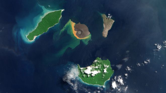
There are about 40 volcanoes worldwide thought capable of doing what Anak Krakatau (centre island) did
image : Copenicus data 2019
From BBC by Jonathan Amos
Shattered remnants from the volcano that generated a devastating tsunami in Indonesia a year ago have been pictured on the seafloor for the first time.
Scientists used sonar equipment to image the giant chunks of rock that slid into the ocean when one side of Anak Krakatau collapsed.
Some of these blocks are 70-90m high.
Their plunge into the water produced tall waves that tore across the shorelines of Java and Sumatra on 22 December 2018.
Over 400 people around the Sunda Strait died in the nighttime disaster, and thousands more were injured and/or displaced.
Dave Tappin recalls the event and describes the blocks of rock on the seabed
Researchers have been trying to reconstruct what happened ever since. But all their studies to date have been based on what can be seen above the water.
Prof Dave Tappin and colleagues realised they had to investigate the island volcano's missing mass - now under the ocean's surface - or they would never truly get a full description of Anak Krakatau's failure.
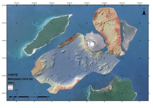
A multibeam echosounder was brought in to map the seabed.
Updated: This simulation shows how the volcano's flank slipped into the water
"Early models of the collapse were based on satellite imagery that only looked at the subaerial parts of the volcano," the British Geological Survey scientist told BBC News.
"Our bathymetry is imaging at 200m water depths and we are seeing triangular-shaped blocks, which are basically coherent and they formed, before the collapse, the southwestern flank of Anak Krakatau."
The debris field runs out to 2,000m from the volcano.
A seismic survey also conducted by the team shows how this material is layered on top of older deposits.
Crucially, the underwater imaging has allowed Prof Tappin's team to revise its estimate for the volume of rock involved in the flank failure.
And it's smaller than previously thought.
Calculations based on above-water measurements of what was left of the once 335m-high volcano had suggested a figure of 0.27 cubic km.
The new assessment now points to 0.19 cubic km sliding into the ocean, almost 200 million cubic metres.
Stephan Grilli: New simulations reproduce the damage observed on nearby islands
This smaller volume might have presented something of a problem for tsunami modellers.
Their original simulations of how the waves generated in the collapse moved across the Sunda Strait had already proved a good match for what had been observed at tide gauges and from what was known of the extent of damage along nearby coasts.
Now, the models are having to be re-run but with a smaller input.
The simulations still work, however - and with good reason.
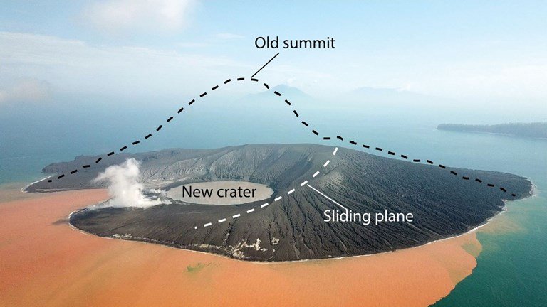
Prof Tappin's team has also discovered that the failure plane on the volcano - the angle of slope along which the rock mass slid - was shallower than earlier assumptions.
Whereas it was once thought the failure plane cut down steeply into the basin created when the old volcano on the site blew its top in 1883, it's now obvious the collapse slope entered the water much nearer the surface.
This simulation, based on the new data, shows how the tsunami moved outwards
"We've already redone the near-field modelling with a finer resolution based on the new bathymetry and the results are about the same, despite having a smaller volume of rock," explained tsunami expert Prof Stephan Grilli from the University of Rhode Island.
"The shallower slide occurs almost like a ski jump, maintaining the collapse material closer to the surface and making it more tsunamigenic than a steeper failure, which would have brought the sediment down deeper, much quicker."
Profs Tappin and Grilli were speaking here in San Francisco at the American Geophysical Union's annual Fall Meeting.
This is the first chance they've had to present their findings to the wider scientific community.
Also speaking was Prof Hermann Fritz from the Georgia Institute of Technology.
He reviewed the damage on nearby shores, describing from on-the-ground studies how high the tsunami waves must have been and how far inland they reached.
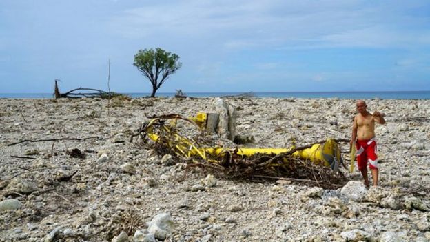
On the islands in the immediate vicinity of Anak Krakatau, trees up to 80m above the normal sea surface were torn from their roots.
Ujung Kulon National Park is due southwest of Anak Krakatau, some 50km away
Much of the wave energy took a path away from the volcano in the same direction of the collapse - to the southwest. This resulted in 10m-high waves laying waste to a corner of Ujung Kulon National Park on Panaitan Island - a distance of 50km from Anak Krakatau.
"Local residents were very fortunate that the collapse was in the southwest direction, in the direction where few people were living - towards the national park," said Prof Fritz.
"Had the collapse direction been different, the outcome could have been very different as well in terms of tsunami heights on populated areas."
Lessons learned from Anak Krakatau are being used to assess the hazards at other volcanoes. There are about 40 other locations around the world where flank collapse into surrounding water is considered a danger.
Anak Krakatau the child of Krakatau, will grow into an island by 1930 with the GeoGarage platform (NGA nautical raster chart)
The map shows the area covered by the bathymetric survey, to the southwest and northeast of Anak Krakatau
Links :


No comments:
Post a Comment