
From the June 19, 1944, issue of TIME. (TIME Magazine)
From Wilts&GloustershireStandard by Brendan McFadden
ON June 6, 1944, Operation Neptune marked the beginning of the invasion of German occupied Europe by the Allied Forces under the command of General Dwight D. Eisenhower.
The Second World War invasion on the Normandy coast of France became commonly known as D-Day, and was the largest amphibious assault ever executed, involving five army divisions supported by over 7,000 ships and 11,000 aircraft.

It is a little known fact that American regiment, the 654th Engineer Topographic Battalion, which was based in Tetbury (UK), had a key role in the success of the invasion, which was a major turning point of the war.
The Second World War invasion on the Normandy coast of France became commonly known as D-Day, and was the largest amphibious assault ever executed, involving five army divisions supported by over 7,000 ships and 11,000 aircraft.

Plans for D-Day were underway months in advance.
It is a little known fact that American regiment, the 654th Engineer Topographic Battalion, which was based in Tetbury (UK), had a key role in the success of the invasion, which was a major turning point of the war.
As part of a top secret project, the Tetbury-based troops devised a 3D map of Omaha Beach which became a vitally important tool used to capture the beach and move inland.
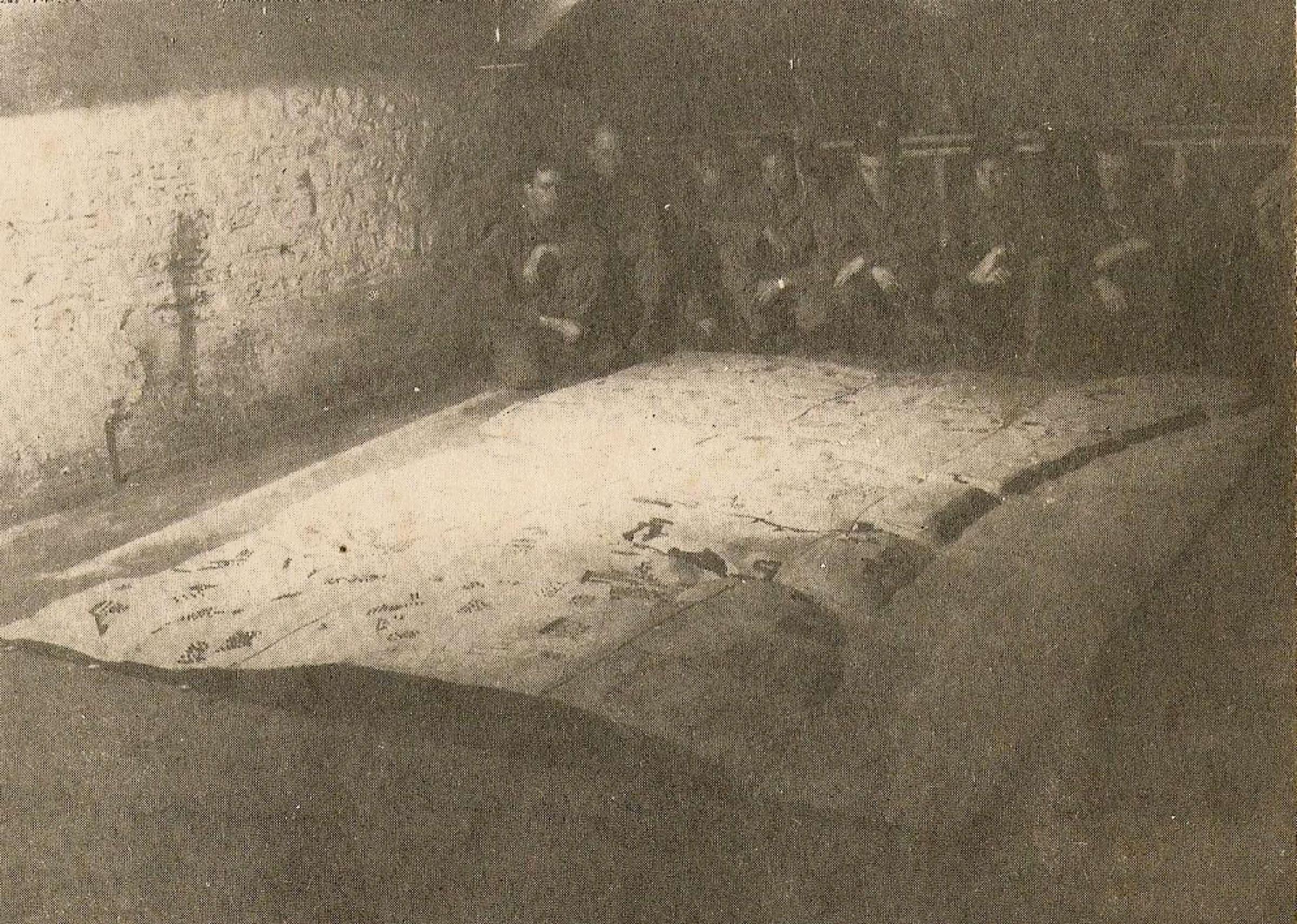
Troops with the 3D map of Omaha beach which they made at the Old Malthouse in Tetbury
Tetbury historian, Merlin Fraser has researched the work of the 300-man regiment, uncovering how they produced eight million ordinance maps, which helped American troops plot their route to Germany following D-Day.

Omaha beach detailed
(other : Utah beach)
Merlin is documenting his findings in a book called the Americans in Tetbury and together with Tetbury Town Council he has worked to install a plaque in the town to commemorate both the 70th anniversary of D-Day and the GI’s work in the town.
“In the grand scheme of all things historical what happened in the small Cotswold market town of Tetbury during the six months prior to those landings paled into obscurity overshadowed by the true horrors of war and what happened on those beaches that day,” Merlin said.
“The American soldiers stationed here were not front line troops and they were not part of that first day, however the work they did was of vital importance to the preparation, planning and execution of both Operation Neptune and Overlord.
“In a nutshell I guess you could say that these troops were part of the ‘Back Room Boys’ of Military Intelligence.”

The plaque, in the north-east corner of the Chipping car park, will look towards the old Malt House, where the 3D model of Omaha was created.
“The American soldiers stationed here were not front line troops and they were not part of that first day, however the work they did was of vital importance to the preparation, planning and execution of both Operation Neptune and Overlord.
“In a nutshell I guess you could say that these troops were part of the ‘Back Room Boys’ of Military Intelligence.”
Wilts and Gloucestershire Standard: Soldiers from the battalion assemble maps
in a trailer in Berlin as part of the American’s march to Germany
in a trailer in Berlin as part of the American’s march to Germany
The plaque, in the north-east corner of the Chipping car park, will look towards the old Malt House, where the 3D model of Omaha was created.
It is being unveiled on Friday, June 6 at 11am by Tetbury mayor Sandra Ball.


Aerial photo shows troops landing on D-Day at Sword Beach, France on June 6, 1944.
(British Ministry of Defense)
The battalion was split into three sections.
Company A, was based in and around the town, including the Old Malt House and was responsible for turning aerial reconnaissance into maps.
Company B was based at nearby Chavenage House and printed the maps.
Company B was based at nearby Chavenage House and printed the maps.
Headquarters and the battalion’s officers were also based there.

In total, 75,215 British and Canadian troops and 57,500 US troops stormed the beaches on D-Day. with 23,400 landing from air by parachute or glider.


After the Normandy Beaches success, the 654th Battalion followed the army across Europe, taking their survey, mapping and printing skills with them.

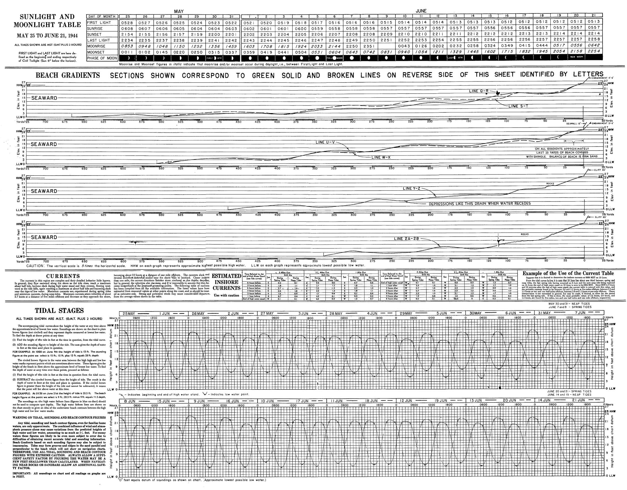
Left : weather maps for 1,2,3 June 1944 at 1300GMT
Right : weather maps for 4 June 1300 GMT and 6 June 0600 GMT
(History of meteorology, James Fleming)
Chris Tubbs Deputy Chief Forecasters at the Met Office UK uses original weather charts for the day of the invasion, Tuesday the 6th of June.
He shows how there were brisk, north westerly winds coming across the country.
However some shelter from the wind and waves was provided in the Channel, enabling the allied, invasion troops to land successfully in Normandy.
In total, 75,215 British and Canadian troops and 57,500 US troops stormed the beaches on D-Day. with 23,400 landing from air by parachute or glider.
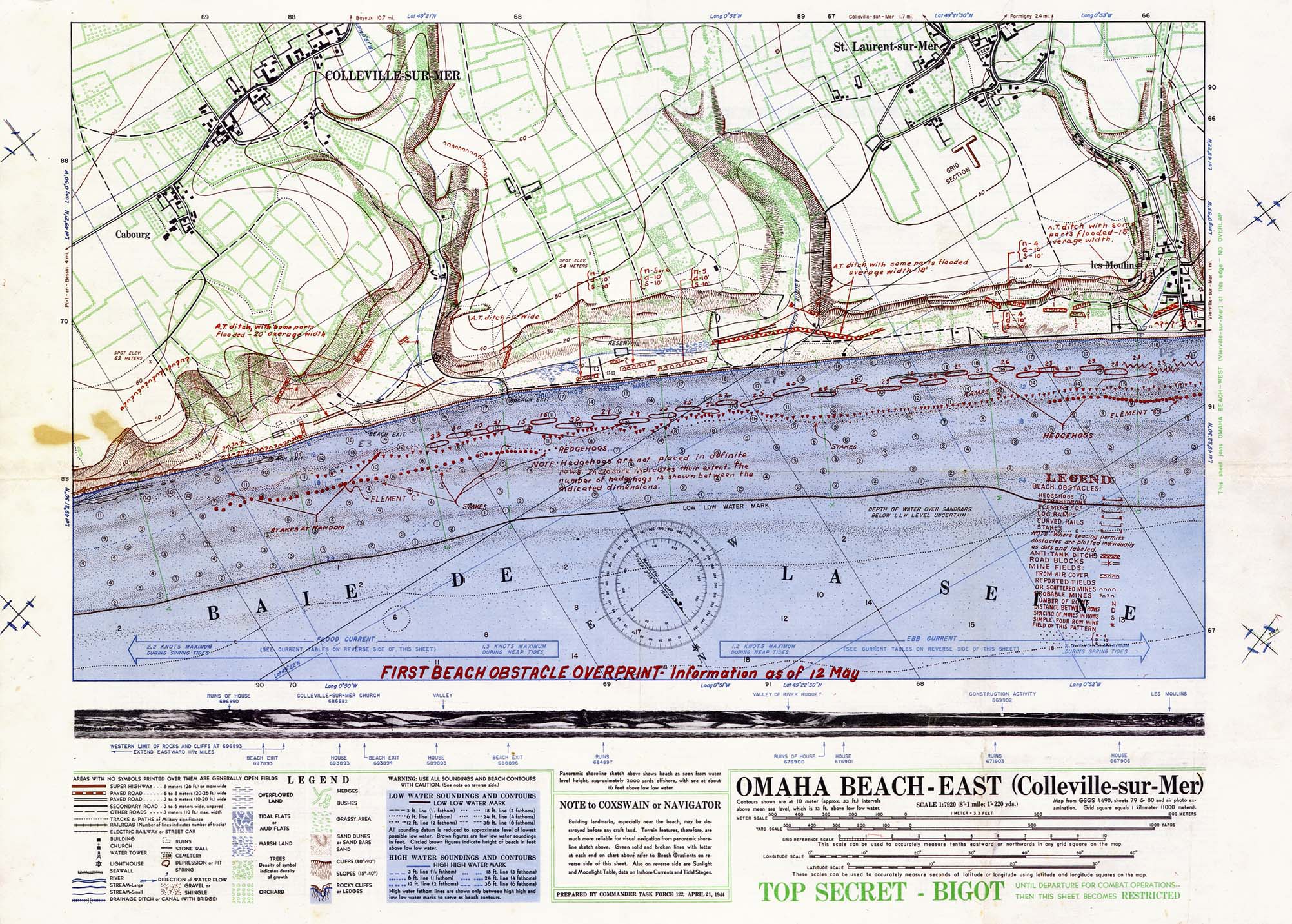

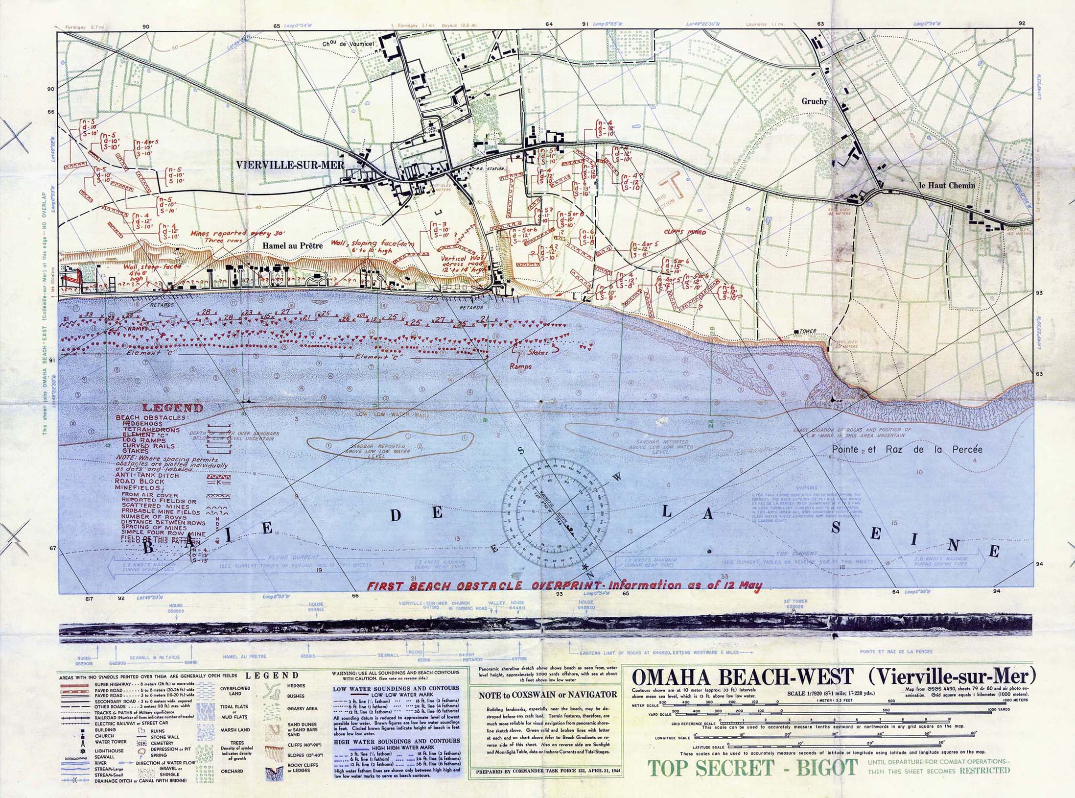
Prepared by the Commander Task Force 122, April 21, 1944.
"Map from GSGS 4490 Sheets 79 and 80 and air photo examination. Grid square equals 1 kilometer (1000 meters)."
Original scale 1:7,920.
"TOP SECRET - BIGOT Until Departure for Combat Operations -- Then This Sheet Becomes RESTRICTED".

'Approaches to Arromanches les Bains'. A chart produced by the UK Hydrographic Department in July 1944 showing the layout of the harbour and soundings collected by HM Motor Launch 1001, the inshore survey vessel assigned to Mulberry B.

A photo mosaic from August 1944 showing an overview of Mulberry B as it was when in service.
(UKHO)
(UKHO)
Merlin explained: “Omaha was the kick-off point but the maps were basically used for any theatre as they advanced." They resurveyed the area as they were advancing.”
Links :
- Gigapan : D-Day map used by the allied forces to plan and execute the D-Day landings.
- AppStore : D-day Hour by Hour
- DailyMail : 'Port Winston' Mulberry harbour built off Normandy after D-Day is uncovered on the seabed 69 years later
- CCOM UNH : High-Resolution Multibeam Sonar as a Tool for Archaeological Investigations: An Example from the D-Day Beaches of Normandy
- UKHO : The Mulberry Harbours
- Dassault Systems : D-Day Landings in 3D Virtual Reality
No comments:
Post a Comment