
Second Thomas Shoal ‘could be the next flashpoint’
The shoal, alternately known as Ayungin (Filipino), Second Thomas (English), or Ren’ai Jiao (named 'Jen-ai Chiao' on the above NGA map) in Chinese, is located 105 nautical miles from the nearest island of the Philippines, Palawan (9°44 N / 115°52' E)
source : NGA chart #93046 Mantangule island to Eran Bay (1:250,000)
>>> geolocalization with the Marine GeoGarage <<<
From Reuters
A wrecked navy transport ship perched on a remote coral reef could be the next flashpoint in the South China Sea, where China and five other claimants bitterly dispute territory.
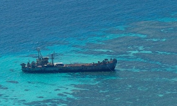
Photo of Filipino wrecked warship (BRP Sierra Madre)
stuck in Ayungin Shoal serves as an outpost for the Philippine Navy
at 25 miles from Mischief Reef occupied by the Chinese.
stuck in Ayungin Shoal serves as an outpost for the Philippine Navy
at 25 miles from Mischief Reef occupied by the Chinese.
-taken by a Chinese helicopter-
The Philippine government is accusing China of encroachment after three Chinese ships, including a naval frigate, converged just 5 nautical miles from an old transport ship that the Philippines deliberately ran aground on a reef in 1999 to mark its territory.
Philippine officials say they fear the Chinese ships will block supplies to about a dozen Filipino marines stationed in abject conditions on the rusting ship, raising tensions over one of Asia's biggest security issues.
The area, known as Second Thomas Shoal, is a strategic gateway to Reed Bank, believed to be rich in oil and natural gas.

Second Thomas shoal (center) with Mischief reef (NW of the island)
source : wikimapia
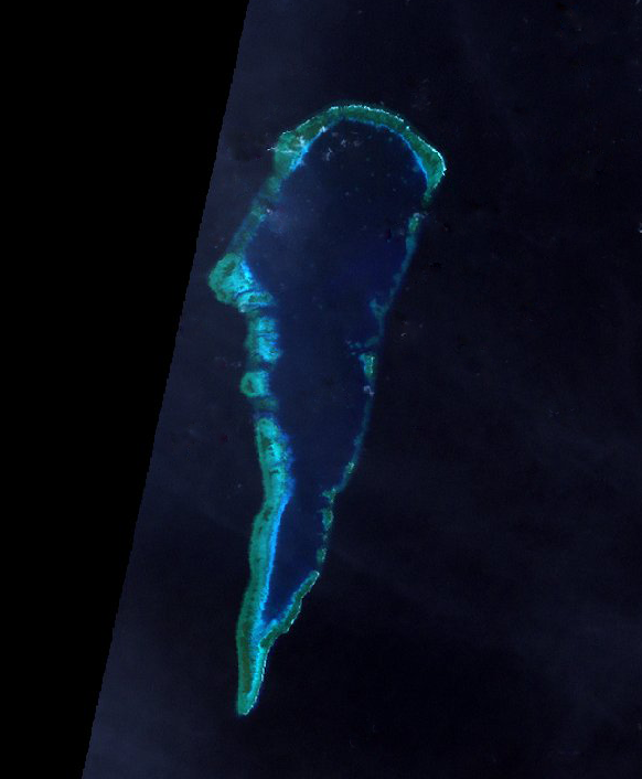
Second Thomas Shoal is an atoll of Spratly Islands.
source NASA : Landsat 7 Path 118 Row 53
(retouched picture, cropped and cleared clouds)
In 2010, Manila awarded an Anglo-Filipino consortium a license to explore for gas on Reed Bank but drilling stalled last year due to the presence of Chinese ships.

Manila says Reed Bank, about 80 nautical miles west of Palawan island at the southwestern end of the Philippine archipelago, is within the country's 200-nautical mile exclusive economic zone.
Beijing says it is part of the Spratlys, a group of 250 uninhabitable islets spread over 165,000 square miles, claimed entirely by China, Taiwan and Vietnam and in part by Malaysia, Brunei and the Philippines.
"China should pull out of the area because under international law, they do not have the right to be there," said Raul Hernandez, a spokesman for the Philippine Department of Foreign Affairs, noting the area's proximity to Palawan, the country's largest province.
He said the Chinese ships were a "provocation and illegal presence".
Chinese Foreign Ministry spokesman Hong Lei said on Tuesday the Second Thomas Shoal was part of the Spratly Islands, over which China had "indisputable sovereignty".
"It is beyond reproach for Chinese boats to carry out patrols in these waters," Hong said, adding China called on all parties to "refrain from taking actions that complicate the situation".
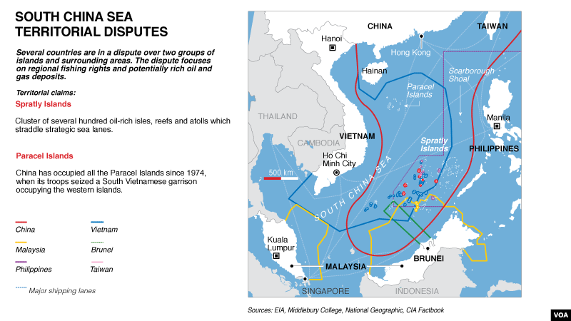
The tension illustrates how a decades-old territorial squabble over the South China Sea is entering a more contentious chapter as claimant nations spread deeper into disputed waters in search of energy supplies, while building up navies and alliances with other nations.
Second Thomas Shoal is one of several possible flashpoints in the South China Sea that could force the United States to intervene in defense of its Southeast Asian allies.
The tension comes just before U.S. Defense Secretary Chuck Hagel meets his Asia-Pacific counterparts at the so-called Shangri-La Dialogue in Singapore at the weekend.
The South China Sea is on the agenda of the regional security forum.
"Clear and present danger"
Philippine authorities say the three Chinese ships arrived in Second Thomas Shoal on or around May 8, escorting a fleet of 30 fishing boats.
Two days later, the Philippines formally lodged a protest with China over the vessels.
As of Tuesday, two Chinese marine surveillance ships remained in the area, Philippine navy spokesman Colonel Edgardo Arevalo said.
The fishing boats and the frigate had left, he said.
"The presence of those ships is a clear and present danger," said another senior Philippine navy officer, who declined to be identified as he is not authorized to speak to the media.
He said the Philippines believed China was trying to pressure it to leave the shoal.
"We don't want to wake up one day with fresh structures sitting near our navy ship there. We have to bite the bullet and strengthen our position there or risk losing the territory."
The wrecked U.S.-built ship, the BRP Sierra Madre, is among Asia's loneliest military outposts.
The ship was launched in World War Two, saw action in Okinawa and was used again in the Vietnam War.
It was transferred to the Philippine government in 1976 under a military assistance program.
Soldiers are equipped with a small generator for cooking.
Radios are battery-powered and supplies are delivered by boat.
"They want us out of the area," another Philippine navy officer said of China.

The island of Kalayaan, which means “Freedom” in Filipino,
that was created in 1978 mainly to assert the Philippines’ claim to the disputed territory
in the Spratlys, a chain of islets in the South China Sea.
(AFP/Kayalaan Municipal Office)
>>> geolocalization with the Marine GeoGarage <<<
 Island of Kalayaan named Zhongye Dao or Thitu island
on NGA chart 93044 -Yongshu Jiao to Yongdeng Ansha (South China)-

on NGA chart 93044 -Yongshu Jiao to Yongdeng Ansha (South China)-
The Association of South East Asian Nations (ASEAN), a 10-nation grouping that includes the Philippines, has been talking to China about a binding code of conduct to ease tension.
But China says it will negotiate "when the time is ripe".
ASEAN foreign ministers are due to meet in Thailand in August to forge a position on the code of conduct before meeting Chinese officials in late August or early September in Beijing.

A newly-constructed radar dome on Chinese-controlled Subi Reef,
in the disputed Spratly islands region.
China says it has sovereign rights over nearly all of the South China Sea,
even waters far away from its main landmass
and approaching the coasts of Southeast Asian countries.
(AFP)

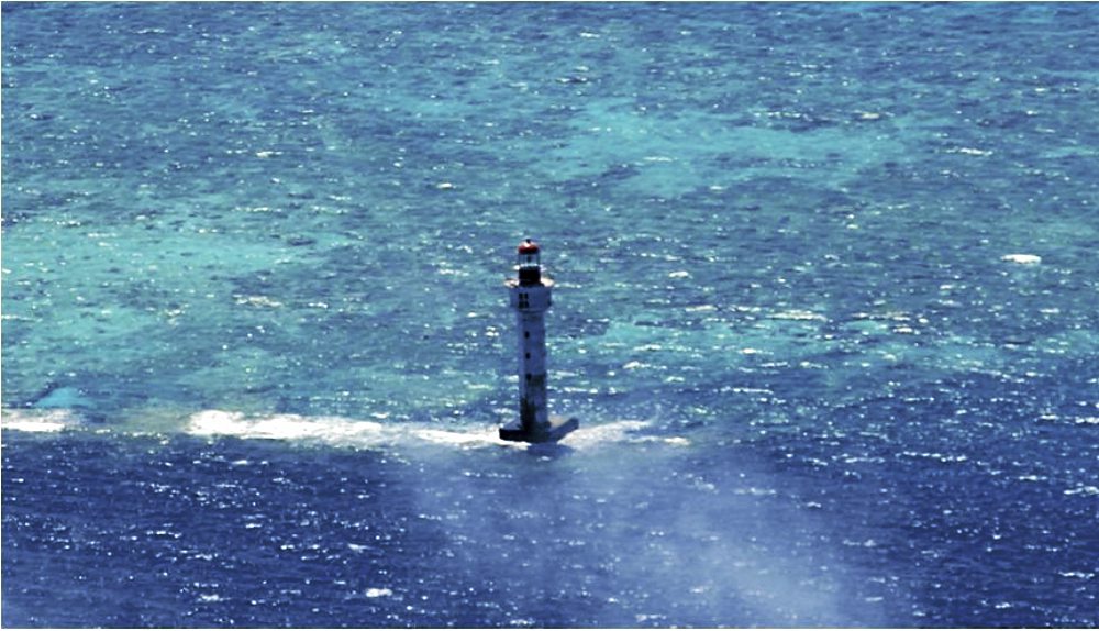
China’s lighthouse located southwest of Subi Reef seen by the Philippine Navy
Under international law, a lighthouse is a recognized base point from where a state can measure its maritime regimes,
including territorial sea (12 nautical miles from the baseline), contiguous zone (24 nm), economic exclusive zone (200 nm), continental shelf (200 nm) and extended continental shelf (350nm).
>>> geolocalization with the Marine GeoGarage <<<
The easternmost territory held by China is Mischief Reef, about 65 km (40 miles) northwest of Second Thomas Shoal.
China occupied it in 1995.
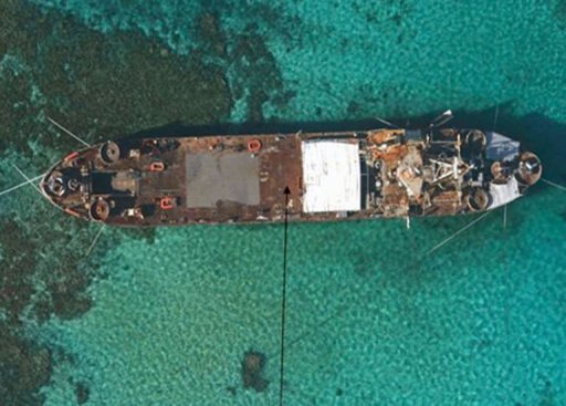
An aerial view of BRP Sierra Madre (LT-57), a 100-metre ship
(Philippine Government)
The Philippines occupied Second Thomas Reef with the BRP Sierra Madre in 1999, preventing China moving further east.
In March, Malaysia protested against the incursion of four Chinese ships in James Shoal, about 80 km (50 miles) off Sarawak on Borneo island.
Chinese sailors fired guns in the air during the visit to the shoal.
Last month, a Chinese maritime surveillance ship returned to James Shoal to leave behind steel markers to assert its claim.
Risk of miscalculation
Zha Daojiong, an international relations professor at Beijing's Peking University, said China was serious about asserting its claims in the South China Sea and it was important the region did not misunderstand this.
"There is now a quiet agreement among different Chinese voices that sometimes you have to act as well as issuing statements," he said.
China would, however, never completely close the door on possible co-operation.
Ian Storey, a scholar at Singapore's Institute of South East Asian Studies, said tension at Second Thomas Shoal could prove more dangerous than last year's stand-off at unoccupied Scarborough Shoal, given the presence of Filipino troops.
"It is hard to imagine China using force to gain full control over Second Thomas, but some kind of blockade to drive out the Philippines' troops would have to be a possibility," Storey said.
"There is a real chance of escalation or miscalculation."
Links :
Interaksyon : Securing the Shoals - What must be done ?
ReplyDeleteNYTimes :A Game of Shark and Minnow
ReplyDelete